[ Archive ]
| CIMSS-NOAA Weekly Report [ Archive ] |
CIMSS AND ASPB WEEKLY HIGHLIGHTS FOR THE WEEK ENDING MARCH 26, 2021
PRODUCTS AND APPLICATIONS:
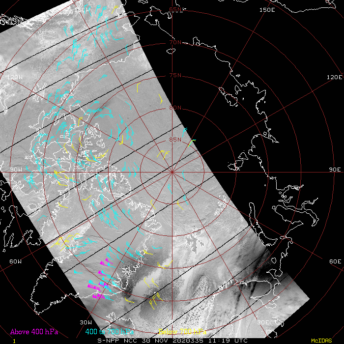
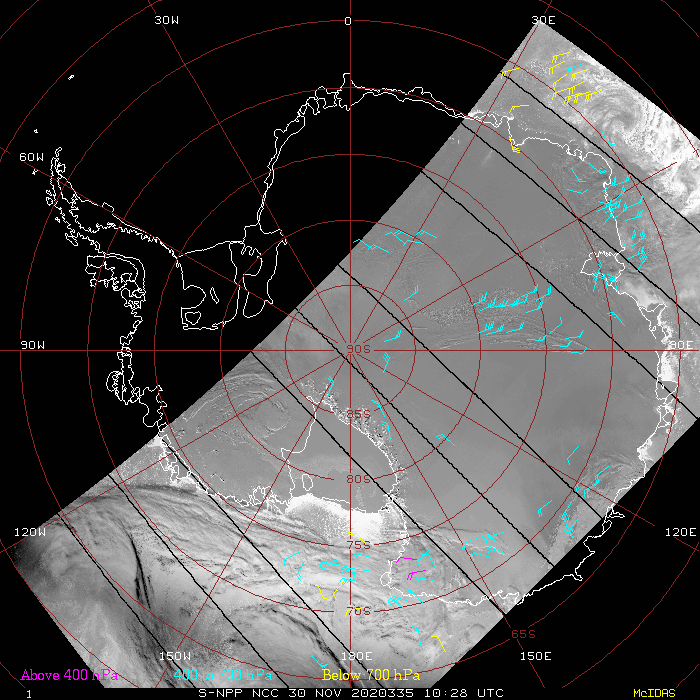
Generation of Polar Winds from VIIRS Day/Night Band Images: The polar winds team at the Cooperative Institute for Meteorological Satellite Studies (CIMSS) did an initial test of the heritage winds algorithm as applied to the Visible Infrared Imaging Radiometer Suite (VIIRS) Day/Night Band (DNB) imagery. Since the dynamic range of the DNB radiances varies by many orders of magnitude depending on solar or lunar illumination, the Near Constant Contrast (NCC) product was employed. NCC provides time-coherent, pseudo-reflectance images for tracking features. As a demonstration, winds were derived from one triplet of orbits using data from the Suomi National Polar-orbiting Partnership (NPP) satellite over each pole on 30 November 2020. The figure figure below depicts the derived-wind coverage over the Arctic at 1300 UTC, which is lunar illuminated in late November; winds over sunlit Antarctica at 1210 UTC are shown in the second figure. The vector heights are calculated using co-located VIIRS infrared brightness temperatures and are color-coded in the figures. Routine generation of the NCC winds is being implemented to test the algorithm in the varying lunar and solar lighting, or lack thereof, and for validation by comparing to other polar winds products. (D. Santek, CIMSS, 608-263-7410, J. Key, E/RA2, 608-263-2605, jeff.key@noaa.gov, D. Stettner, CIMSS, 608-262-8850)
 (Click image to enlarge)
Figure: VIIRS NCC polar winds in the Arctic from Suomi NPP on 30 November 2020 at 1300 UTC, color coded by height: Yellow (below 700 hPa), cyan (400 to 700 hPa), magenta (above 400 hPa).
 (Click image to enlarge)
Figure: VIIRS NCC polar winds in the Antarctic from Suomi NPP on 30 November 2020 at 1210 UTC, color coded by height: Yellow (below 700 hPa), cyan (400 to 700 hPa), magenta (above 400 hPa).
AWARDS AND RECOGNITION:
PUBLICATIONS:
Paper Published on Record-Low Cloud Temperaratures Associated With a Tropical Deep Convective Event: A paper titled "Record‐Low Cloud Temperatures Associated With a Tropical Deep Convective Event" was published in Geophysical Research Letters (https://agupubs.onlinelibrary.wiley.com/doi/10.1029/2020GL092261). Scott Bachmeier (Cooperative Institute for Meteorological Satellite Studies, CIMSS) is a co-author. The paper documents thunderstorm overshoots in the tropical West Pacific on December 29, 2018 that resulted in the Visible Infrared Imaging Radiometer Suite (VIIRS) aboard NOAA‐20 measuring a temperature of 161.96K (−111.2°C), potentially the coldest on record. (S. Bachmeier, CIMSS).
WORKSHOPS, CONFERENCES, AND MEETINGS:
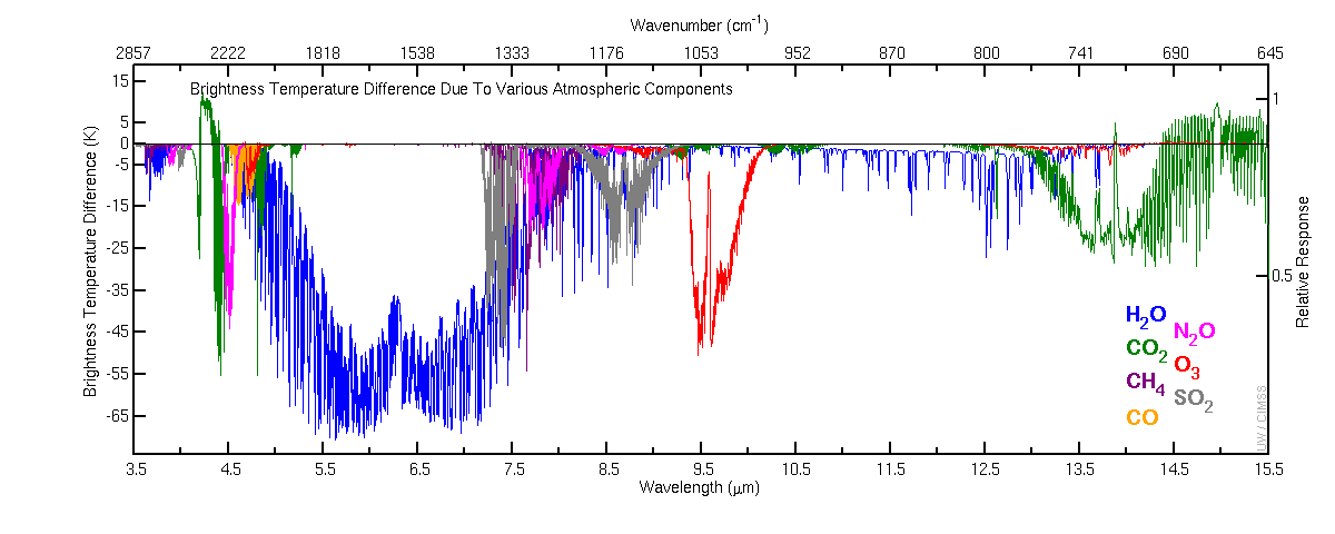
CIMSS scientists Brief NESDIS and NWS on shortwave water vapor bands: Scientists from the Cooperative Institute for Meteorological Satellite Studies (CIMSS) at the University of Wisconsin-Madison provided a briefing on initial results from a shortwave water vapor study for the next-generation Geostationary Extended Observations (GeoXO) Imager (GXI), which, among other potential improvements, could have two new bands (one for sensing low-level, boundary-layer, water vapor and another with higher spatial resolution to improve our ability to find turbulence). The briefing was provided to GOES-R Scientist Dan Lindsey and Senior Scientist for Geostationary Earth Observations Andy Heidinger on March 11, 2021 and then separately to National Weather Service personnel, including from the Office of Observations, Jordan Gerth, Brian Gockel, and James Yoe on March 19. This briefing (slides available upon request) highlighted the methodologies and early results studying shortwave water vapor bands and the potential utility of these bands for future geostationary observations. (M. Gunshor, matg@ssec.wisc.edu, CIMSS, T. Schmit, E/RA2, 608-263-0291, tim.j.schmit@noaa.gov, T. L’Ecuyer (CIMSS), N. Gordillo (CIMSS), A. Merrelli (CIMSS), & N. Miller (CIMSS).
 (Click image to enlarge)
Figure: This spectral plot indicates the impacts (in brightness temperature difference) of 7 gases of interest as measured in the US Standard Atmosphere (1976) spectrum, caused by removing these atmospheric components individually in a forward model (colored lines) along with the spectral response functions (SRFs, black curves) of the ten GOES-16 Advanced Baseline Imager (ABI) infrared bands. Scientists are studying whether a shortwave water vapor band around 5.6μm could help better detect turbulence if spatial resolution is improved to nominally 1 km and if we could sense lower level moisture, without interference from other absorbing gasses, around 5.1μm.
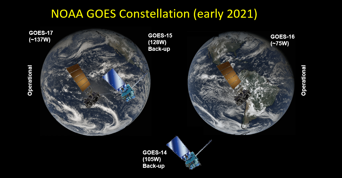
GOES Presentation to Taiwanese Students: On March 22, 2021, Tim Schmit (remotely) gave an invited presentation in the Meteorological & Environmental Remote Sensing Virtual Online Seminar series, which is hosted by the National Central University in Taiwan. The history of Geostationary Operational Environmental Satellite (GOES), the current status and a glimpse into the future were covered. The presentation is available upon request. (T. Schmit, E/RA2, 608-263-0291)
 (Click image to enlarge)
Figure: A snapshot of the current U.S. Geostationary Operational Environmental Satellite (GOES) constellation.
TRAINING AND EDUCATION:
VISIT Training on TROWALs for the Glasgow Forecast Office (WFO GGW): Scott Lindstrom from the Cooperative Institute for Meteorological Satellite Studies (CIMSS) presented a Virtual Institute for Satellite Integration Training (VISIT) module on Troughs of Warm Air Aloft (TROWAL) to forecasters at the Glasgow, MT, forecast office (WFO GGW). This training was augmented with imagery/analyses from the strong Front Range storm of 14 March 2021, and the training was recorded for forecasters who could not attend. (Scott Lindstrom, CIMSS, 608 263 4425)
MEDIA AND OUTREACH:
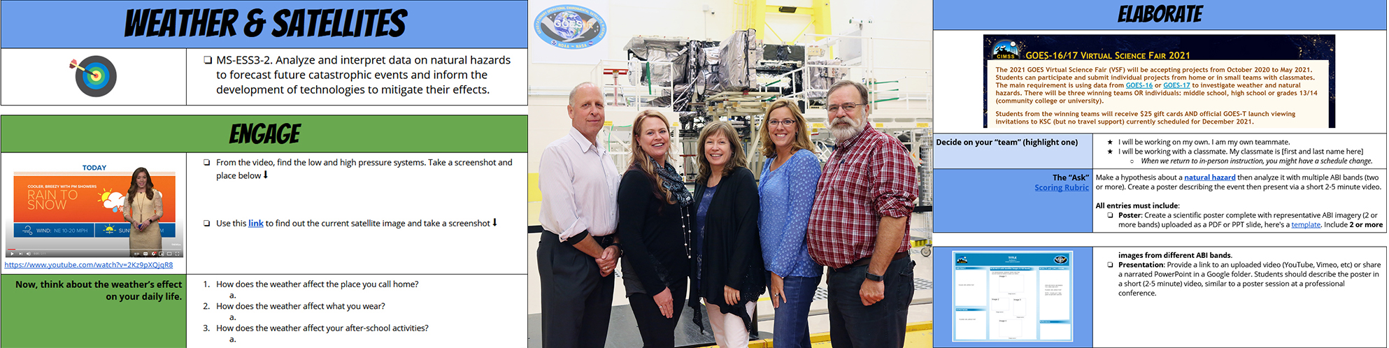
Colorado Educators promote Satellite Data and the GOES Virtual Science Fair: Teachers from Jefferson County, Colorado (Team JeffCO) independently developed and shared a complete learning module on weather and satellites that promotes student engagement with GOES data and the GOES 16/17 Virtual Science Fair. The teachers joined the GOES-R Education Proving Ground at NOAA CIMSS (Cooperative Institute for Meteorological Satellite Studies) in 2017 when they attended the GOES-S Teacher Workshop at Lockheed Martin (http://cimss.ssec.wisc.edu/education/goesr/GOES-S.html). The new lesson plan has been posted to CIMSS social media channels and added as a resource to the GOES-R Education Proving Ground web page. (M. Mooney, CIMSS, margaret.mooney@ssec.wisc.edu)
 (Click image to enlarge)
Figure: Colorado Educators and GOES-S (center) flanked by screenshots of their new lesson plan.
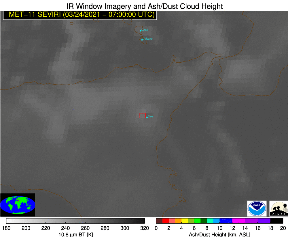
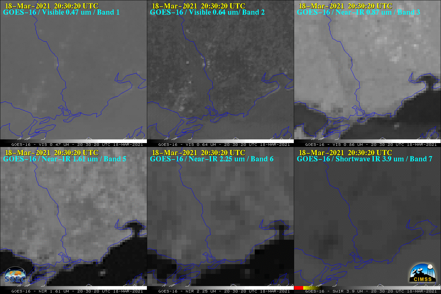
SSEC and CIMSS Scientists in the News: Scientists at the University of Wisconsin-Madison (UW) Space Science and Engineering Center (SSEC) and the Cooperative Institute for Meteorological Satellite Studies (CIMSS) provide expert interviews, imagery and case studies to promote science. This week: 1) CIMSS Satellite Blog contributors Scott Bachmeier and Scott Lindstrom published case studies on "Satellite signature of the Falcon 9 re-entry" (Mar. 26), "Severe weather across the Deep South and Mid-South" (Mar. 25), "Eruption of Mount Etna" (Mar. 24), "Stratus and fog along the US East Coast" (Mar. 23),"Creating and Displaying gridded GLM fields using data from NOAA CLASS" (Mar. 23), "Turbulence detection near Alaska" (Mar. 22), and "Surface low off the coast of Florida" (Mar. 21). Read more: https://cimss.ssec.wisc.edu/satellite-blog/. (J. Phillips, SSEC, 608-262-8164, S. Bachmeier, CIMSS, S. Lindstrom, CIMSS)
 (Click image to enlarge)
Figure: Meteosat-11 ash height retrievals from the NOAA/CIMSS Volcanic Cloud Monitoring site showed the eruption of Mount Etna in Sicily, Italy on Mar. 24.2021 and the associated ash cloud that rose to 7-8 km. Read more: https://cimss.ssec.wisc.edu/satellite-blog/archives/40382. Credit: CIMSS, NOAA, EUMETSAT.
 (Click image to enlarge)
Figure: NASA conducted a SLS rocket Green Run Test at Stennis Space Center in southern Mississippi on Mar. 18, 2021. Signatures of the resulting condensation cloud were evident in GOES-16 ABI spectral bands as well as a dark shadow cast by the cloud. Read more: https://cimss.ssec.wisc.edu/satellite-blog/archives/40321. Credit: CIMSS.
OTHER:
| Archived Weeklies Page | Submit a report item |