[ Archive ]
| CIMSS-NOAA Weekly Report [ Archive ] |
CIMSS AND ASPB WEEKLY HIGHLIGHTS FOR THE WEEK ENDING MAY 7, 2021
PRODUCTS AND APPLICATIONS:
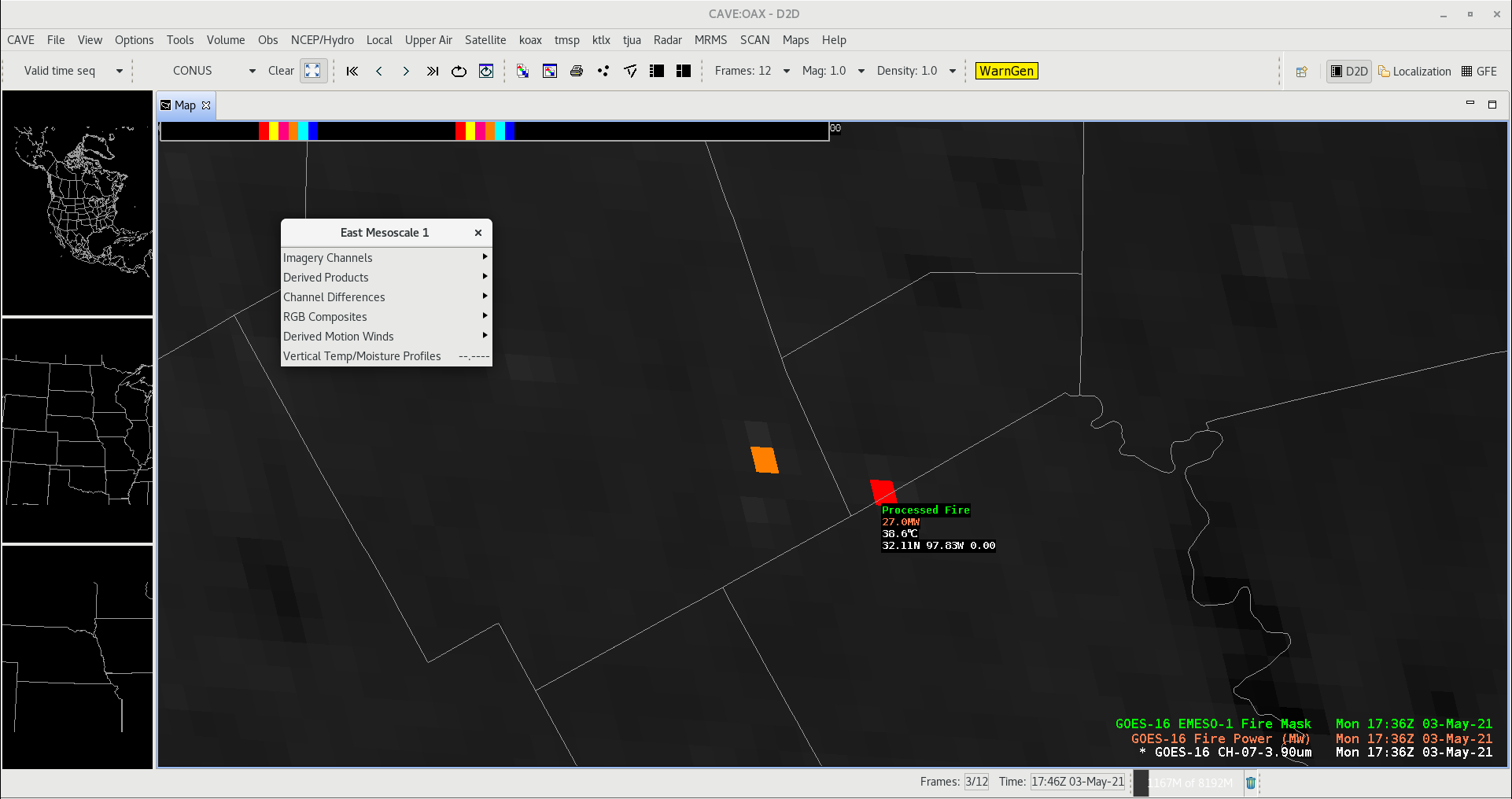
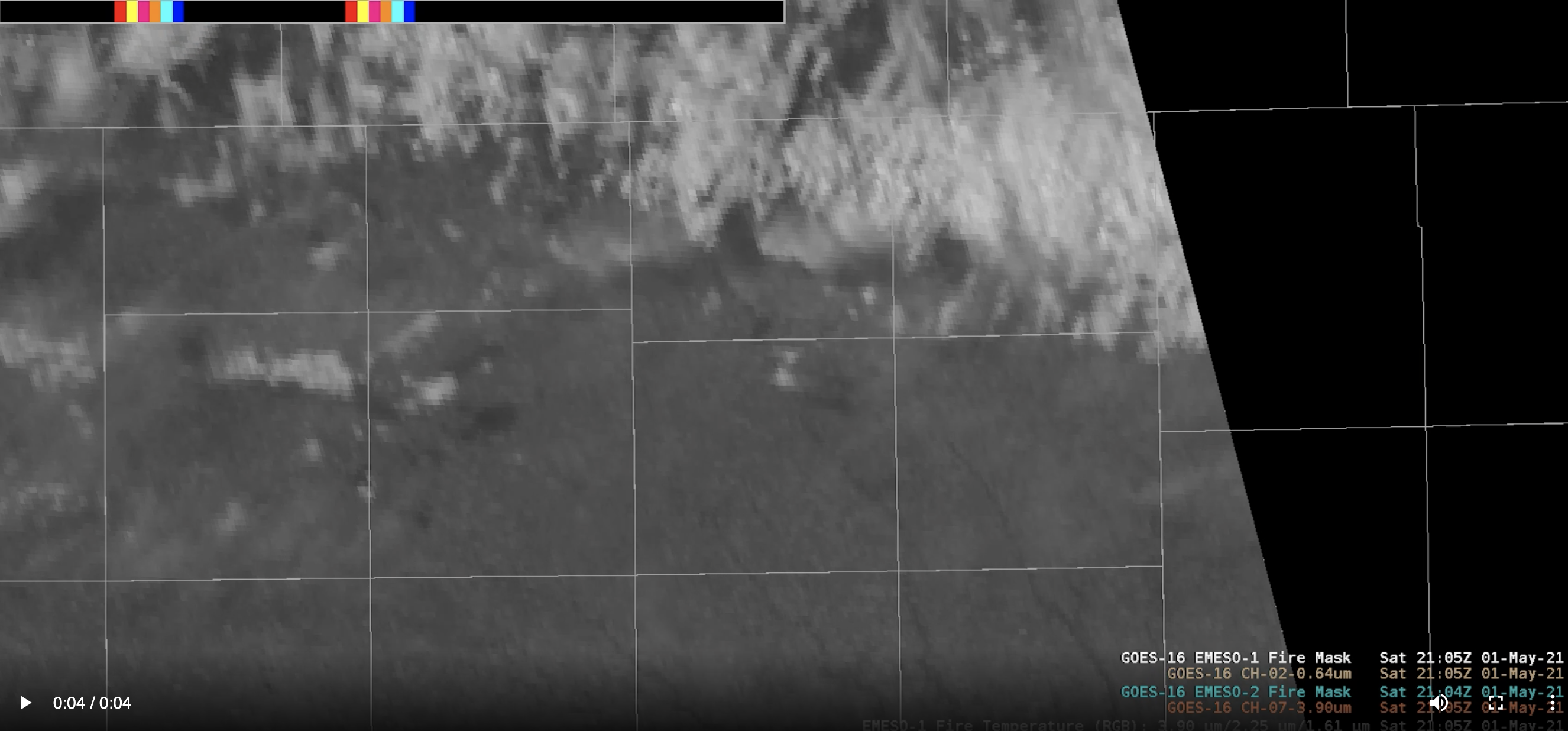
GOES-16/-17 Fire Algorithm Running on Mesoscale Scans: In response to requests from National Weather Service forecasters (NWS) and other users, the Fire Detection and Characterization Algorithm (FDCA) is now being produced for the Geostationary Operational Environmental Satellite (GOES)-16 and -17 Mesoscale domain sectors, providing the FDCA products, fire radiative power (FRP), size, temperature, and metadata mask, to NWS Offices at one minute temporal resolution. The associated software and configuration updates will begin rolling out to NWS offices in late May/early June 2021. Lee Byerle (NOAA Affiliate, GOES-R Program Office) demonstrated the FDC Mesoscale product for Chris Schmidt and Scott Lindstrom of the Cooperative Institute for Meteorological Satellite Studies (CIMSS) in the cloud implementation of the Advanced Weather Interactive Processing System (AWIPS). The figure below is a screen capture from AWIPS on the cloud showing a fire in Texas on May 3, 2021 and the associated readout provided by AWIPS. The loop below shows the AWIPS display of FDC Mesoscale data over Eastern Iowa on May 1, 2021, a day with a high risk of fire spread in Iowa. A large fire is seen developing and fading out over the course of a few minutes, and there is an associated smoke plume seen after the fire has been detected. The increased temporal resolution of the Mesoscale FDC data gives users an earlier notification of a developing fire, in this case even before a smoke plume was visible, and can give them greater confidence in the detection due to the repeated detections over time. Combining the FDC product with visible data helps the users identify false positives, such as due to small water clouds and solar farms. (C. Schmidt, CIMSS, 608-262-7973, S. Lindstrom, CIMSS)
 (Click image to enlarge)
Figure: AWIPS screenshot of the Fire Detection and Characterization Algorithm (FDCA) product showing a fire over Texas. An upcoming update will allow NWS offices to visualize the FDCA mask product for the first time, as well as provide access to FDCA data processed for the Mesoscale domain sector scans.
 (Click image to enlarge)
Figure: AWIPS loop (click for animation) of Fire Detection and Characterization Algorithm (FDCA) Mesoscale products over Eastern Iowa on May 1, 2021. A dry and windy day, there were a high risk of fire spread, and as this loop demonstrates the FDCA product detecting the fire before the smoke plume was visible.
AWARDS AND RECOGNITION:
PUBLICATIONS:
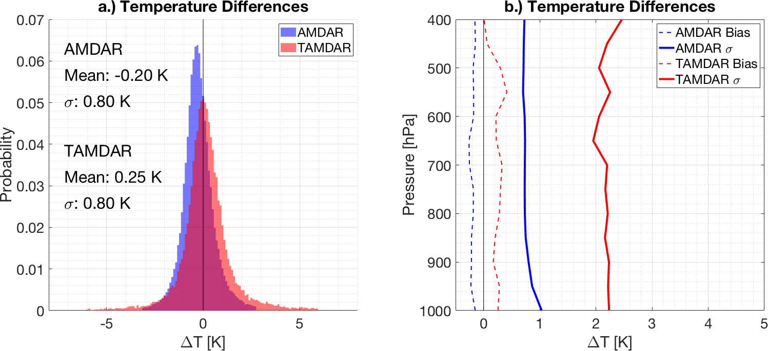
Aircraft-Based Observations Paper Accepted for Publication: Recent work at the Cooperative Institute for Meteorological Satellite Studies (CIMSS) has focused on validating two separate aircraft-based observation systems: the Aircraft Meteorological Data Relay (AMDAR) and the Tropospheric Airborne Meteorological Data Reporting (TAMDAR). AMDAR is a partnership between the World Meteorological Organization (WMO) and various major airlines while TAMDAR is a private sector data provider that contracts with smaller airlines to host their equipment. Certain AMDAR observations are augmented with the Water vapor Sensing System-II (WVSS-II) to measure atmospheric moisture. In general, it was found that AMDAR observations outperform TAMDAR observations for all assessed variables (temperature, relative humidity, specific humidity, wind) at all heights when compared to radiosondes, with both smaller mean differences and smaller uncertainties. Full details have been published in a paper recently accepted to the Journal of Atmospheric and Oceanic Technology, which is now available in early online release to subscribers at https://doi.org/10.1175/JTECH-D-20-0182.1. (T. Wagner, CIMSS, 608-890-1980; R. Petersen, CIMSS, 608-263-4030).
 (Click image to enlarge)
Figure: a) Histogram of aircraft-minus-radiosonde differences for both AMDAR (blue) and TAMDAR (red) in 0.1 K bins. b) Vertical profile of the mean (dashed) and standard deviation (solid) for the AMDAR (blue) and TAMDAR (red) temperature differences. Data are aggregated into 50 hPa bins.
WORKSHOPS, CONFERENCES, AND MEETINGS:
TRAINING AND EDUCATION:
Satellite training at the National Weather Service office in Columbia SC: Scott Lindstrom from the Cooperative Institute for Meteorological Satellite Studies (CIMSS) presented a one-hour live (but remote) training to new forecasters at the National Weather Service forecast office in Columbia, SC (WFO CAE). This was done at the request of the Science and Operations Officer (SOO) at that office, Frank Alsheimer. The training included information on parallax and on the 16 channels on the GOES-16 Advanced Baseline Imager (ABI), and how individual bands, band differences, and Red-Green-Blue (RGB) composites can be used with and without GOES-16 Level 2 derived products to aid in a forecaster’s daily tasks. The training was recorded for forecasters who were unable to attend. (S. Lindstrom, CIMSS, 608 263 4425)
MEDIA AND OUTREACH:
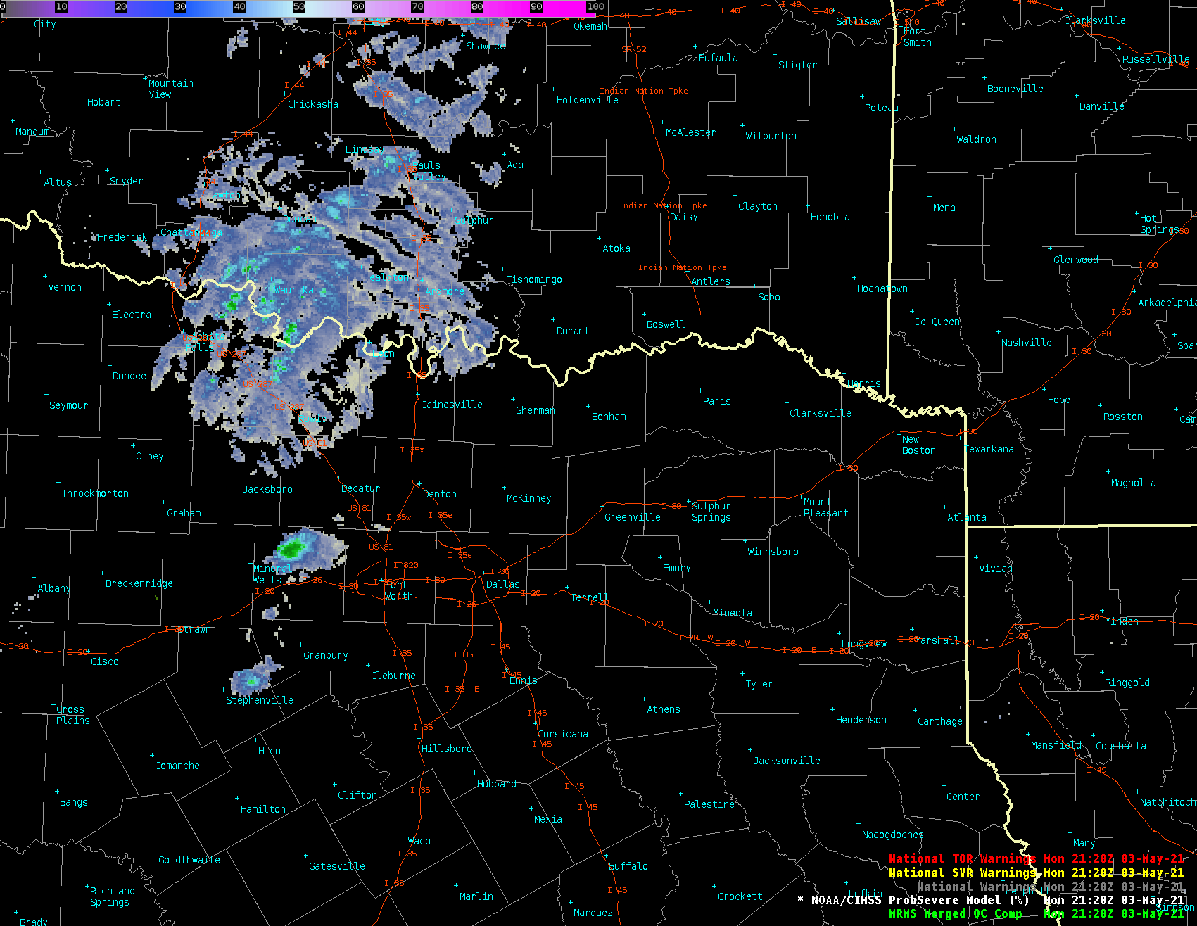
SSEC and CIMSS Scientists in the News: Scientists at the University of Wisconsin-Madison (UW) Space Science and Engineering Center (SSEC) and the Cooperative Institute for Meteorological Satellite Studies (CIMSS) provide expert interviews, imagery and case studies to promote science. This week: 1) NCEI scientist Jim Kossin was interviewed for an upcoming special on hurricanes and climate change that will air on NBC-TV in Fort Lauderdale, FL. He was also interviewed by John Schwartz of the New York Times for a forthcoming story on hurricanes and climate change. 2) NOAA ASPB scientist Mike Pavolonis was interviewed for an EoS story on the Volcanic Cloud Analysis Toolkit (VOLCAT) that detects and tracks volcanic ash clouds in order to mitigate ash-related aviation hazards. VOLCAT was developed in collaboration with CIMSS researchers. Read more: https://eos.org/articles/eyeing-explosive-ash-clouds-from-above-and-below. 3) CIMSS Satellite Blog contributors Scott Bachmeier and John Cintineo published case studies on "Blowing dust across Mongolia and China" (May 6), "Severe weather across much of the Southeast US" (May 4), "ProbSevere products over the Southern Plains" (May 3), and "Blowing dust behind the outflow of a severe thunderstorm in Colorado" (May 2). Read more: https://cimss.ssec.wisc.edu/satellite-blog/. (J. Phillips, SSEC, 608-262-8164, J. Kossin, NCEI, M. Pavolonis, E/RA2, 608-263-9597, S. Bachmeier, CIMSS, J. Cintineo, CIMSS)
 (Click image to enlarge)
Figure: Himawari-8 images showing multiple dust plumes that originated in Mongolia and were transported across northeastern China on May 4-6, 2021. Read more: https://cimss.ssec.wisc.edu/satellite-blog/archives/40860. Credit: CIMSS, JMA.
 (Click image to enlarge)
Figure: ProbSevere v3 contours (colored, around storms), MRMS MergedReflectivity, and NWS severe weather warnings (yellow and red boxes) for storms over the Southern Plains on May 3, 2021. The second outer contour around some storms is colored by the probability of tornado. Read more: https://cimss.ssec.wisc.edu/satellite-blog/archives/40827. Credit: CIMSS, NOAA.
OTHER:
| Archived Weeklies Page | Submit a report item |