[ Archive ]
| CIMSS-NOAA Weekly Report [ Archive ] |
CIMSS AND ASPB WEEKLY HIGHLIGHTS FOR THE WEEK ENDING MAY 28, 2021
PRODUCTS AND APPLICATIONS:
VIIRS Sees A-76 Iceberg Break-off and Partial Breakup: The JPSS Visible Infrared Imaging Radiometer Suite (VIIRS) provided a clear view of the A-76 iceberg that broke off the Ronne Ice Shelf in West Antarctica in early May. A-76, named by the US National Ice Center (NIC), is one of the largest icebergs to break off from Antarctica in the recent past and currently the largest in the world. This finger-shaped block of ice is considerably larger than Rhode Island, and larger than the Spanish island of Majorca. While A-76 is very large, it is only about one-third the size of the biggest iceberg in recorded history. That record belongs to an iceberg named B-15, which calved off the Ross Ice Shelf 21 years ago. A-76 is not thought to be a direct result of climate change. Calving of ice shelves is a natural process, part of the hydrological cycle. For more information and an animation of VIIRS imagery, visit https://bit.ly/2RRToJ4. (J. Key, E/RA2, 608-263-2605, jeff.key@noaa.gov)
 (Click image to enlarge)
Figure: The Antarctic iceberg A-76 as viewed by the VIIRS I5 band. Image courtesy of CIRA.
AWARDS AND RECOGNITION:
PUBLICATIONS:
Manuscript on geostationary hyperspectral infrared sounder channel selection published: A manuscript titled "Geostationary Hyperspectral Infrared Sounder Channel Selection for Capturing Fast-Changing Atmospheric Information" has been published in IEEE Transactions on Geoscience and Remote Sensing (https://ieeexplore.ieee.org/document/9438955). In this study, an adjusted algorithm is proposed for geostationary hyperspectral infrared sounder channel selection, which is ideal for data assimilation application. Compared with the conventional algorithm (information entropy iterative method), the adjusted algorithm is able to select the channels for monitoring atmospheric temporal variation while retaining the information content from the conventional method. The one-dimensional variational (1Dvar) retrieval experiment also verifies the superiority of this adjusted algorithm; it indicates that using the channel selected by the adjusted algorithm could enhance the water vapor profile retrieval accuracy, especially for the lower and middle troposphere atmosphere. CIMSS co-author is Jun Li (the corresponding author). (Jun Li, CIMSS, Jun.Li@ssec.wisc.edu)
WORKSHOPS, CONFERENCES, AND MEETINGS:
Master's Student Thesis on Machine Learning and GOES Artifacts: On May 13, 2021, Ronald O. Adomako, NOAA Center for Earth System Sciences and Remote Sensing Technologies (CESSRST), presented results on his thesis titled "Geostationary Operational Environmental Satellite] GOES-R Supervised Machine Learning and Anomalies". The Master's thesis was completed on May 24. This work was part of a NERTO (NOAA Experiential Research & Training Opportunities) internship. It also included generating some histograms and Empirical Cumulative Distribution Functions of GOES-16 and GOES-17 brightness temperatures in the overlap region (http://cimss.ssec.wisc.edu/goes-r/abi-/band_statistics_imagery.html). Historically these internships could only be held at official federal facilities, but due to COVID-19, the internship was held virtually. (R. Adomako, NOAA-CESSRST; T. Schmit, E/RA2, 608-263-0291)
.png) (Click image to enlarge)
(Click image to enlarge)
Figure: Distribution panels for GOES-16/17 comparison: GOES-16 histogram (top left), GOES-17 histogram (top right), empirical cumulative distribution function (lower left), and GOES-17 transform vs GOES-16 plot (lower right). Note this is a day/time/band (Feb 1, 2021, 13:10 UTC, ABI band 8) where the GOES-17 brightness temperatures were highly affected by the Loop Heat Pipe issue.
Participation in the UFS Land Modeling Workshop: Jason Otkin participated in a virtual workshop that brought together modeling and data assimilation experts to discuss development priorities to enhance the ability of the Unified Forecast System (UFS) to model the land surface. Otkin was a facilitator for a breakout session discussing the verification of land surface forecasts at subseasonal-to-seasonal (S2S) time scales. (J. Otkin, CIMSS, 608-265-2476)
TRAINING AND EDUCATION:
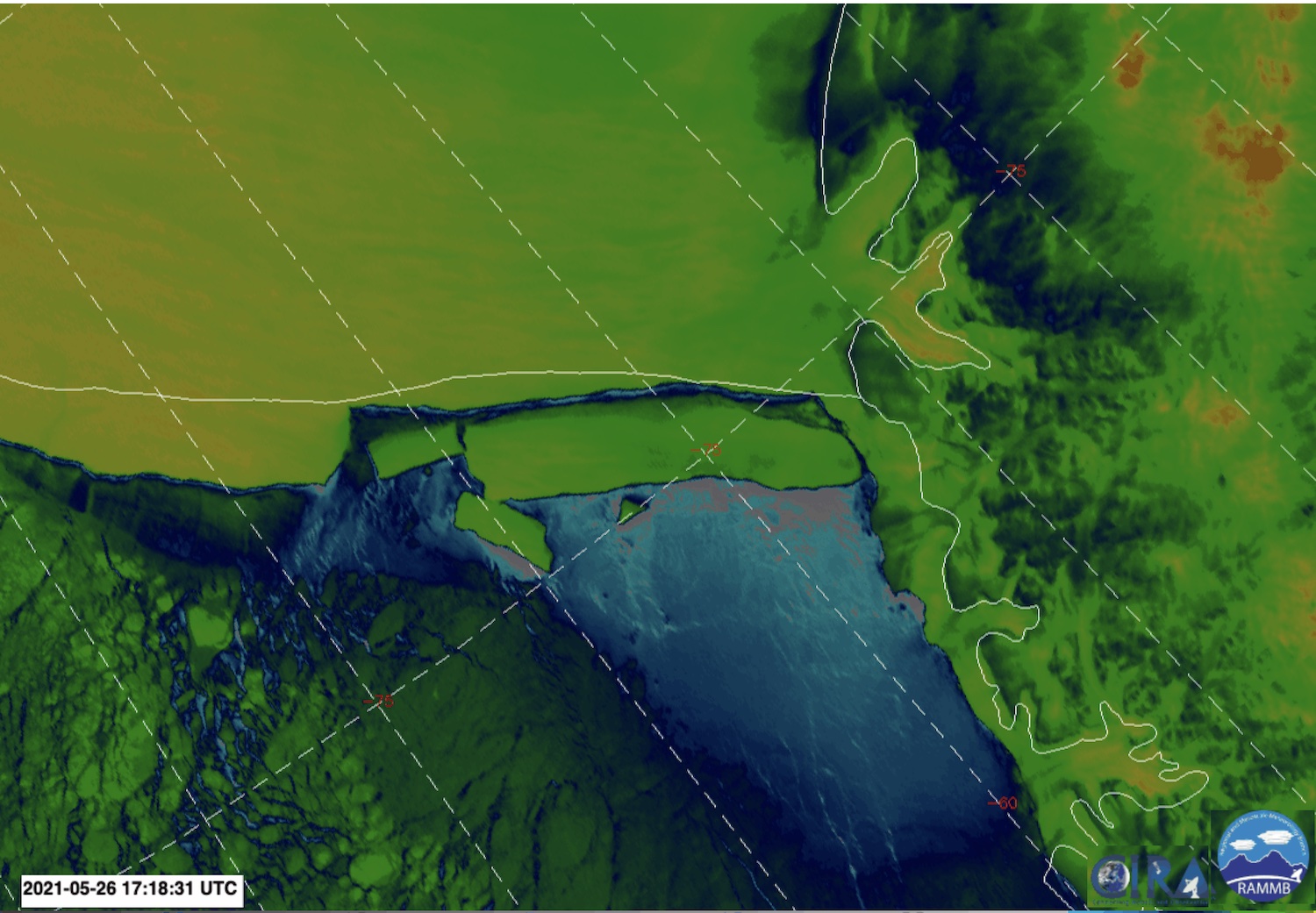
CIMSS Training at WFO Sullivan: Scott Lindstrom from the Cooperative Institute for Meteorological Satellite Studies (CIMSS), gave a training session on GOES-16 ABI Satellite information to forecasters at the Sullivan, WI, National Weather Service office (WFO MKX). This remotely-delivered training served as a reminder about various aspects of GOES-16 Satellite imagery and was developed at the request of the office’s Science and Operations Officer (SOO). Subjects included parallax, individual ABI bands, and different Red/Green/Blue (RGB) composite products that can be used to monitor glaciation (or, in some cases, substitute in for radar), alert for fires, or evaluate model initialization. The hour-long training was recorded and uploaded to YouTube for use by forecasters who could not attend. (S. Lindstrom, CIMSS, 608 263 4425)
 (Click image to enlarge)
Figure: Word Cloud from CIMSS Training to WFO MKX.
MEDIA AND OUTREACH:
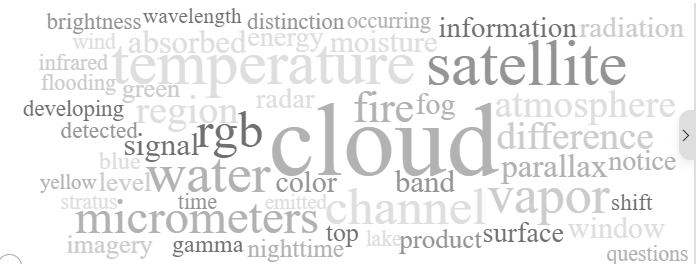
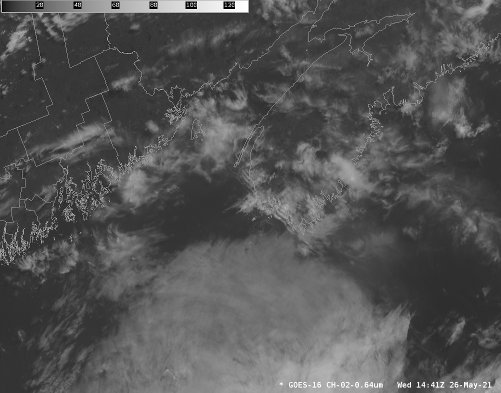
SSEC and CIMSS Scientists in the News: Scientists at the University of Wisconsin-Madison (UW) Space Science and Engineering Center (SSEC) and the Cooperative Institute for Meteorological Satellite Studies (CIMSS) provide expert interviews, imagery and case studies to promote science. This week: 1) The CIMSS Tropical Cyclones Group, led by Chris Velden, contributed to Climate Central's 2021 Hurricane Season Preview with an updated graphic showing strongest tropical cyclones since 1979. Read more: https://medialibrary.climatecentral.org/resources/2021-hurricane-season-preview. 2) CIMSS Satellite Blog contributors Scott Bachmeier and Scott Lindstrom published case studies on "Subtropical storm in the South Pacific" (May 27), "Standing waves upstream of Nova Scotia" (May 26), "SAR winds with convection over Lake Superior" (May 25), "Blowing dust in the Upper Midwest " (May 24, 25), "Tropical Invest 90L becomes Subtropical Storm Ana in the Atlantic" (May 21-22). Read more: https://cimss.ssec.wisc.edu/satellite-blog/. (J. Phillips, SSEC, 608-262-8164, C. Velden, CIMSS, S. Bachmeier, CIMSS, S. Lindstrom, CIMSS)
 (Click image to enlarge)
Figure: Graphic showing strongest tropical cyclones since 1979 based on Advanced Dvorak Technique. Read more: https://medialibrary.climatecentral.org/resources/2021-hurricane-season-preview. Credit: C. Velden, CIMSS and CIMSS Tropical Cyclones Group.
 (Click image to enlarge)
Figure: GOES-16 visible imagery showing the development of standing waves upwind of southwestern Nova Scotia on May 26, 2021. Read more in the CIMSS Satellite Blog post: https://cimss.ssec.wisc.edu/satellite-blog/archives/40957. Credit: CIMSS.
OTHER:
| Archived Weeklies Page | Submit a report item |