[ Archive ]
| CIMSS-NOAA Weekly Report [ Archive ] |
CIMSS AND ASPB WEEKLY HIGHLIGHTS FOR THE WEEK ENDING JUNE 18, 2021
PRODUCTS AND APPLICATIONS:
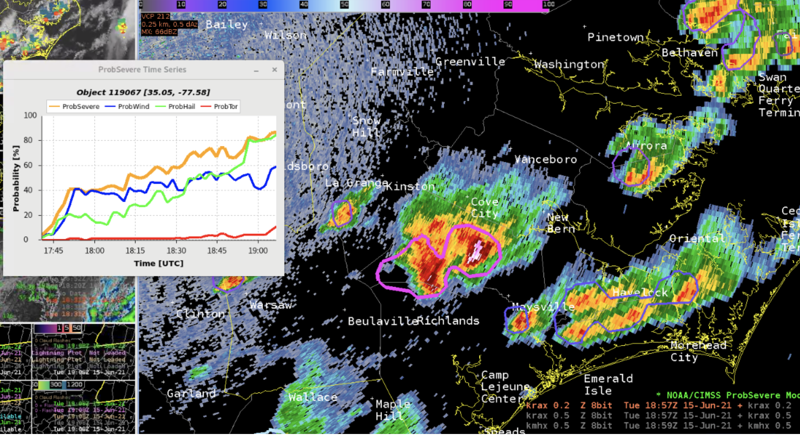
ProbSevere v3 demonstrated at the Hazardous Weather Testbed: The experimental ProbSevere version 3 (PSv3) models were demonstrated and evaluated at the Hazardous Weather Testbed Experimental Warning Program, which was held virtually for the last three weeks. PSv3 uses machine-learning models that fuse together satellite, radar, and lightning observations, as well as environmental data from rapid-refresh NWP output, to produce short-term probabilistic guidance for severe hazards over the CONUS. Forecasters have generally noted improvements in the performance and calibration of PSv3 models, compared to the operational ProbSevere v2. The improvements can enhance NWS warning confidence and potentially lead-time to severe hazards. (Mike Pavolonis, NOAA/NESDIS/STAR; John Cintineo, Justin Sieglaff and Lee Cronce CIMSS).
 (Click image to enlarge)
Figure: A screenshot of ProbSevere guidance from an HWT forecaster's Common AWIPS Visualization Environment (CAVE).
AWARDS AND RECOGNITION:
PUBLICATIONS:
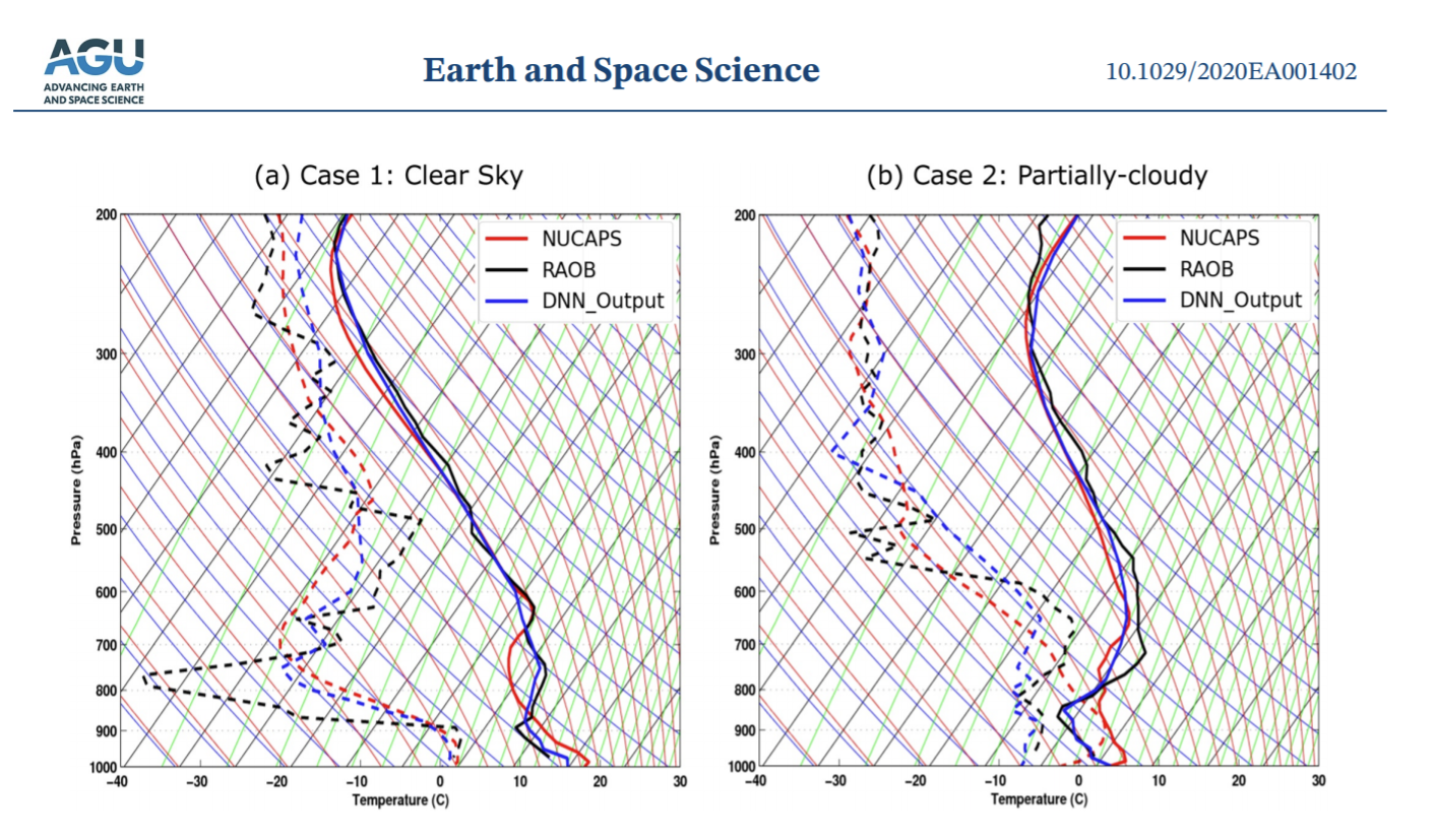
Manuscript on Enhancing Low Level Atmospheric Profiles Published: A manuscript titled "Enhance Low Level Temperature and Moisture profiles through Combining NOAA Unique Combined Atmospheric Processing System (NUCAPS), ABI observations and RTMA analysis" has been published in Earth and Space Science (https://agupubs.onlinelibrary.wiley.com/doi/10.1029/2020EA001402). Through combining satellite observations, including NUCAPS sounding retrievals and high resolution geostationary satellite observations from the Advanced Baseline Imager (ABI), and surface analysis from the Real-Time Mesoscale Analysis (RTMA), the atmospheric temperature and moisture profiles are improved by reducing the root-mean-squared-error (RMSE) by more than 30% in the lower atmosphere (from 700 hPa to the surface) in both clear sky and partially cloudy conditions. Analysis on a convective event from 18 June 2017 illustrates the application of the enhanced low level soundings on nowcasting the high impact weather events. The enhanced soundings from fused data capture the large surface-based convective available potential energy (SBCAPE) structures in the pre-convection environment, which is very useful for severe storm nowcasting and forecasting applications. CIMSS coauthors include Jun Li and Zhenglong Li (corresponding authors); STAR coauthor is Tim Schmit. (T. Schmit, E/RA2, 608-263-0291)
 (Click image to enlarge)
Figure: Figure 7. Temperature (solid lines) and relative humidity (dashed lines) profiles plotted in skew-t diagrams for (a) clear sky case with NUCAPS at 1742 UTC, RAOB launched at 1633UTC, and output of the DNN data fusing model based on the NUCAPS sounding on April 26, 2018, and (b) partly cloudy case with NUCAPS sounding at 0710 UTC, and RAOB at 0727UTC from on April 18, 2018. DNN, deep neural network; NUCAPS, NOAA Unique Combined Atmospheric Processing System; RAOB, radiosonde observations. The retrievals with the merged information improves the NUCAPS alone retrievals, especially near the surface.
WORKSHOPS, CONFERENCES, AND MEETINGS:
TRAINING AND EDUCATION:
CIMSS Participation in Badger Precollege Online Program, Week 1: Cooperative Institute for Meteorological Satellite Studies (CIMSS) scientist Alexa Ross led and coordinated the first of a two-week Summer Course for High School students. These lectures and activities grew from a Tech Camp at CIMSS in 2019, but this year were online and coordinated through the Badger Precollege Online Program on the UW-Madison campus. CIMSS was able to offer three full scholarships to Madison area students from groups that are often underrepresented in science and technology fields. Topics covered included Atmospheric Radiation and Satellite Meteorology (Scott Lindstrom, CIMSS); GIS systems and RealEarth (Sam Batzli); Web-site construction and WxSats (Clayton Suplinski); the Antarctic Meteorology Research Center (Matthew Lazzara). Students also heard presentations from an Early Career Panel, and from presenters who showed examples of scientific posters. (Alexa Ross, CIMSS; S. Lindstrom, CIMSS; S. Batzli, CIMSS; C. Suplinksi, CIMSS; M. Lazzara, CIMSS/MATC).
 (Click image to enlarge)
Figure: High School students were taught how to use WxSats to simulate a view of Earth from a weather satellite's perspective. (Credit: Clayton Suplinski)
Short Course on Satellite Applications: Scott Lindstrom from the Cooperative Institute for Meteorological Satellite Studies (CIMSS) led a 90-minute short-course presentation in webinar format for 40 graduate and undergraduate student members of the American Meteorological Society (AMS). This was a lead-off presentation for the Short Course that has been organized by the Satellite Meteorology and Oceanography and Climatology (SatMOC) committee of the AMS (“Virtual Training Sessions on Satellite Applications”: https://bit.ly/2TIy7SP). The topics covered were data resources available online, and methods to display data from the CLASS archive. Software packages such as Geo2Grid and SIFT (The Satellite Information and Familiarization Tool), both developed by CIMSS scientists, were demonstrated. The webinar was recorded and will be available on the AMS website. (S. Lindstrom, CIMSS, 608 263 4425)
MEDIA AND OUTREACH:
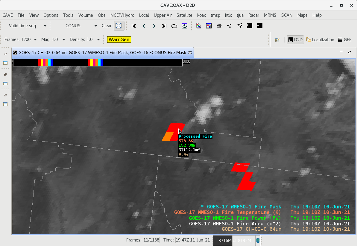
GOES-16/-17 Fires Presentation at the Satellite Book Club Seminar Series: Chris Schmidt of the Cooperative Institute for Meteorological Satellite Studies (CIMSS) gave a presentation on recent updates to the Advanced Weather Interactive Processing System (AWIPS) application of the Geostationary Operational Environmental Satellite (GOES) Fire Detection and Characterization Algorithm (FDCA) to the Satellite Book Club (SBC) Seminar Series. The SBC is hosted by the Total Operational Weather Readiness-Satellites (TOWR-S) Team from the National Weather Weather Service (NWS) Office of Observations. The recent updates to the FDCA product in AWIPS include providing the fire mask component of the FDCA for the first time as well as the FDCA for the GOES-16/-17 1-minute Mesoscale domain sectors. The other FDCA products that have been available to NWS offices since the Advanced Baseline Imager (ABI) products became available are fire radiative power (FRP), size, and temperature. The presentation included a general discussion of the science of the FDCA, examination of Colorado's October 2020 East Troublesome Fire, examples of how the FDCA products appear in AWIPS, discussion of the advantages of the new 1-minute Mesoscale FDCA data, and a discussion of common problems, such as reflections from small water clouds triggering false positive fire detections. The figure below is a screenshot from AWIPS on the Cloud of a FDCA detected fire in southeastern Utah on 10 June 2021 as seen by GOES-17, showing the mask overlaid on the high resolution visible data and the associated readout for one of the pixels. The presentation was recorded and can be found on the SBC's Youtube page at https://youtu.be/y8wFIoSeusM. (C. Schmidt, CIMSS, 608-262-7973)
 (Click image to enlarge)
Figure: AWIPS screenshot of the Fire Detection and Characterization Algorithm (FDCA) product showing a fire over southeastern Utah. All four product fields of the GOES-17 FDCA data are shown overlaid on top of the high resolution visible data from GOES-17.
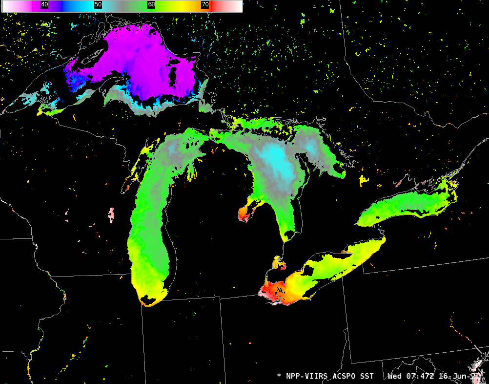
SSEC and CIMSS Scientists in the News: Scientists at the University of Wisconsin-Madison (UW) Space Science and Engineering Center (SSEC) and the Cooperative Institute for Meteorological Satellite Studies (CIMSS) provide expert interviews, imagery and case studies to promote science. This week: 1) SSEC Director Brad Pierce was interviewed by Madison's WKOW about how researchers tracked a fire at the Rockton, IL Chemtool facility and pollution risks from it. Read more: https://go.wisc.edu/li16h0. 2) CIMSS Satellite Blog contributors Scott Bachmeier and Scott Lindstrom published case studies on the "Potential Tropical Cyclone 3 in the Gulf of Mexico" (June 17), "Rapid Convective Initiation and NUCAPS Profiles in the upper Midwest" (June 17), "Lake Surface Temperatures in the Great Lakes in mid-June" (June 16), "Tropical Storm Bill in the Atlantic Ocean" (June 15), "Chemtool facility fire in Rockton, Illinois" (June 14), and "Near-surface winds over the south Pacific Ocean" (June 14). Read more: https://cimss.ssec.wisc.edu/satellite-blog/. (J. Phillips, SSEC, 608-262-8164, B. Pierce, SSEC, S. Bachmeier, CIMSS, S. Lindstrom, CIMSS)
 (Click image to enlarge)
Figure: GOES-16 imagery showed the formation of Potential Tropical Cyclone 3 in the Gulf of Mexico on June 17, 2021. Read the CIMSS Satellite Blog Post: https://cimss.ssec.wisc.edu/satellite-blog/archives/41163. Credit: CIMSS.
 (Click image to enlarge)
Figure: Mostly clear skies over the Great Lakes early on June 16, 2021 allowed the VIIRS instrument on Suomi-NPP an unobstructed view of the surface waters. The image shows temperature distributions across the five lakes. Read the CIMSS Satellite Blog post: https://cimss.ssec.wisc.edu/satellite-blog/archives/41133. Credit: CIMSS.
OTHER:
| Archived Weeklies Page | Submit a report item |