[ Archive ]
| CIMSS-NOAA Weekly Report [ Archive ] |
CIMSS AND ASPB WEEKLY HIGHLIGHTS FOR THE WEEK ENDING JULY 2, 2021
PRODUCTS AND APPLICATIONS:
CIMSS Satellite Blog Imagery Used in Texas Record Hail Event Report: Geostationary Operational Environmental Satellite (GOES-16) imagery from the Cooperative Institute for Meteorological Satellite Studies (CIMSS) Satellite Blog (https://cimss.ssec.wisc.edu/satellite-blog/archives/40797) was used in the State Climate Extremes Committee report (https://www.ncdc.noaa.gov/monitoring-content/extremes/scec/reports/20210624-Texas-Hailstone.pdf) to verify that the 6.4-inch hailstone that fell in southern Texas on 28 April 2021 qualified as a new state record in terms of hail size, weight and volume. (S. Bachmeier, CIMSS)
Generation of Low-latitude Tandem Winds from VIIRS Infrared Images: The polar winds team at the Cooperative Institute for Meteorological Satellite Studies (CIMSS) did an initial test generation of tandem winds using the heritage winds algorithm as applied to the Visible Infrared Imaging Radiometer Suite (VIIRS) infrared imagery. Unlike the traditional wind derivation using triplets of images, tandem winds use a pair of images. Moreover, by using alternating orbits of data from Suomi National Polar-orbiting Partnership (SNPP) and NOAA-20, the winds from VIIRS will not be limited to the polar regions, but will extend to all latitudes. As a demonstration, winds were derived from the equator to 60N latitude using data from the SNPP and NOAA-20 satellites on 23 June 2021 at approximately 1430 UTC. The figure depicts the two orbits overlaid with the raw winds (no quality control) in the overlap region. Next steps are to routinely generate the tandem winds, correct for parallax, apply quality control, and validate by comparing to other satellite-derived winds products. (D. Santek, CIMSS, 608-263-7410, J. Key, E/RA2, 608-263-2605, jeff.key@noaa.gov)
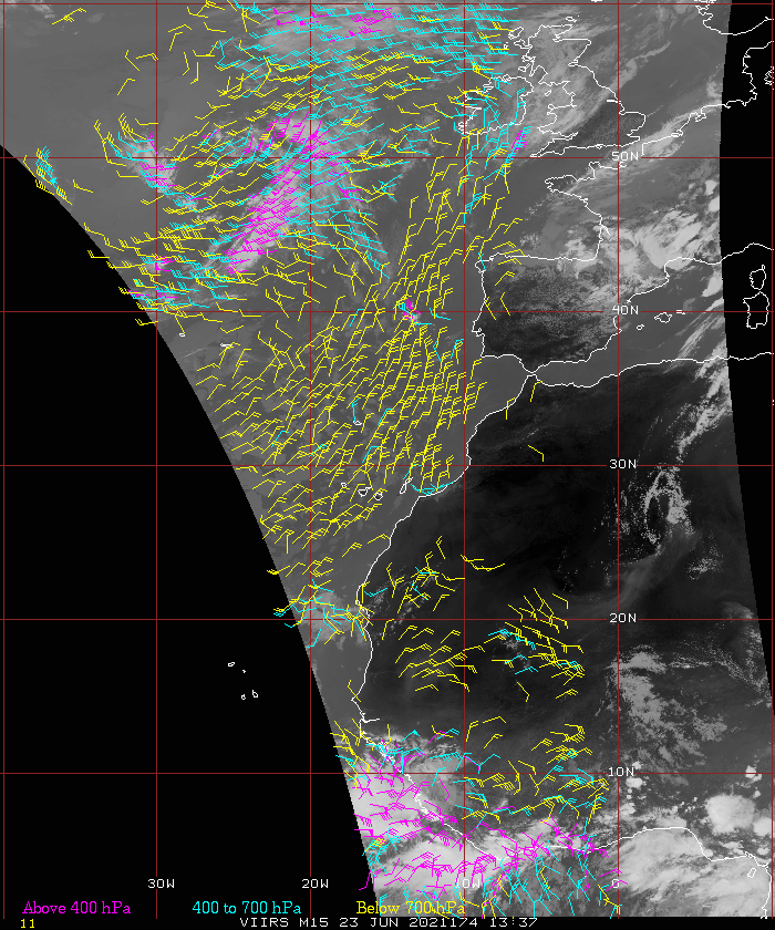 (Click image to enlarge)
Figure: The first example of tandem winds based on two orbits rather than three. The example is for 23 June 2021 at 1430 UTC covering latitudes from the equator to 60N. Yellow AMVs are below 700 hPa; cyan are 400-700 hPa; and magenta are above 400 hPa.
AWARDS AND RECOGNITION:
PUBLICATIONS:
WORKSHOPS, CONFERENCES, AND MEETINGS:
TRAINING AND EDUCATION:
CIMSS Participation in Badger Summer Scholars, Week 2: Cooperative Institute for Meteorological Satellite Studies (CIMSS) Scientist Alexa Ross led and coordinated the first of a two-week Summer Course for Madison Area High School students. These lectures and activities were online and coordinated through the Badger Precollege Online series on the University of Wisconsin-Madison campus. Topics covered this week included programming with Matlab (Alexa Ross); Engineering and Instrumentation insights (Claire Petterson); Ice and Rock drilling (Krissy Slawny); and Tornadoes, thunderstorms and derechos (Leigh Orf). Students were asked at the end of class to create scientific posters The students' topics ranged from identifying cloud types to showcasing Catatumbo Lighting. (Alexa Ross, CIMSS; C. Petterson, CIMSS; K. Slawny, SSEC; L. Orf, CIMSS)
Training Material for GOES-R Level-2 FDCA Products: The presentation of the Fire Detection and Characterization Algorithm (FDCA) output in the Advanced Weather Information Processing System (AWIPS) displays in National Weather Service forecast offices has recently been augmented. Training on the FDCA has been updated to reflect the inclusion of FDCA processing masks in AWIPS: Processed, Saturated, Cloudy, High/Medium/Low Probability fires. The 2-page “Quick Guide” and recorded “Quick Brief” are available on NOAA’s VLAB and through the AWIPS Interactive Resource (AIR), and they're available from CIMSS websites as well (S. Lindstrom, CIMSS, 608 263 4425; Chris Schmidt, CIMSS)
MEDIA AND OUTREACH:
CIMSS Satellite Blog Updates: The Cooperative Institute for Meteorological Satellite Studies (CIMSS) Satellite Blog (https://cimss.ssec.wisc.edu/satellite-blog/) was updated with the posts "Pacific Northwest Heatwave" (June 27), "Strong winds from SAR over the South Pacific" (June 28), "SAR winds over Lake Michigan compared with radar winds" (June 28), "Tropical Depression Four off the South Carolina coast (June 28), "Subtropical Storm Raoni off the coast of South America" (June 28), "Pyrocumulonimbus clouds over British Columbia and California" (June 30) and "Tropical Storm Elsa forms in the Atlantic" (July 1). (S. Lindstrom, CIMSS, S. Bachmeier, CIMSS)
OTHER:
| Archived Weeklies Page | Submit a report item |