[ Archive ]
| CIMSS-NOAA Weekly Report [ Archive ] |
CIMSS AND ASPB WEEKLY HIGHLIGHTS FOR THE WEEK ENDING JULY 16, 2021
PRODUCTS AND APPLICATIONS:
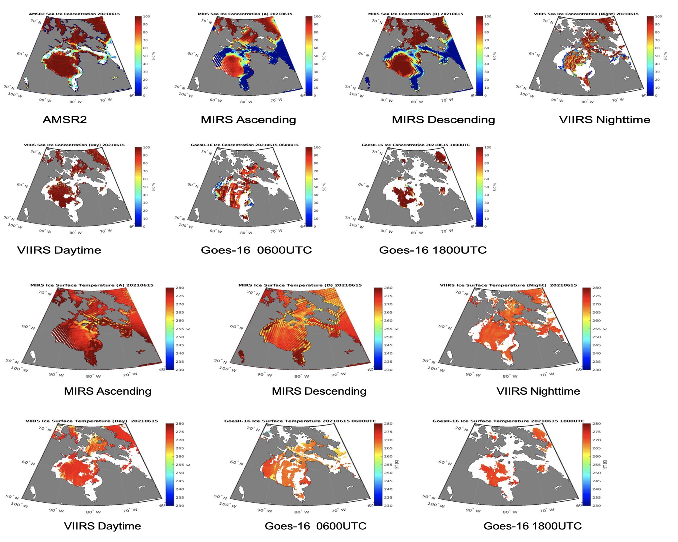
Automatic satellite-derived ice product comparison: The JPSS and GOES-R cryosphere team developed a system to collect NOAA satellite-derived ice products over the Northern America, remap them to a common grid, plot the products side by side for visual comparison, and provide some simple statistics on their differences. All steps are automatic and are running in near-real time at the Cooperative Institute for Meteorological Satellite Studies (CIMSS). The motivation was to be able to examine various ice properties for any area of interest. The products currently include ice concentration, ice surface temperature, and ice thickness. The system provides a tool to detect potential product issues, and will eventually provide users with a robust set of ice information over Northern America. A designated website is being developed to host these figures and statistics. An example for ice concentration and ice surface temperature in Hudson Bay and the Canadian Archipelago is given in the figure below. (H. Zhang, CIMSS, 608-263-2348; Y. Liu, E/RA2, 608-890-1893, yinghui.liu@noaa.gov; J. Key, E/RA2, 608-263-2605, jeff.key@noaa.gov)
 (Click image to enlarge)
Figure: Ice concentration (top two rows) and ice surface temperature (bottom two rows) from AMSR2 (concentration only), MIRS (ascending and descending orbits), VIIRS (nighttime and daytime), and GOES-16 (0600 and 1800 UTC) on 15 June 2021 over Hudson Bay.
AWARDS AND RECOGNITION:
PUBLICATIONS:
WORKSHOPS, CONFERENCES, AND MEETINGS:
TRAINING AND EDUCATION:
MEDIA AND OUTREACH:
SSEC and CIMSS Scientists in the News: Scientists at the University of Wisconsin-Madison (UW) Space Science and Engineering Center (SSEC) and the Cooperative Institute for Meteorological Satellite Studies (CIMSS) provide expert interviews, imagery and case studies to promote science. This week: 1) CarbonBrief published a story -- with contributions from Jim Kossin, CIMSS -- explaining a recent Nature Communications article on a new, complete record of Atlantic hurricanes from 1851 to 2019. Read more: https://www.carbonbrief.org/recent-increase-in-major-atlantic-hurricanes-may-be-rebound-after-1960-1980s-lull. 2. CIMSS Satellite Blog contributors John Cintineo and Scott Bachmeier published case studies on "Forecasting lightning" (July 15), "Pyrocumulonimbus cloud produced by the Bootleg Fire in Oregon" (July 14), and "Thunderstorms over the Chukchi Sea and Beaufort Sea north of Alaska" (July 12). Read more: https://cimss.ssec.wisc.edu/satellite-blog/. (J. Phillips, SSEC, 608-262-8164, J. Kossin, CIMSS, 608-265-5356, jpkossin@wisc.edu, J. Cintineo, CIMSS, S. Bachmeier, CIMSS)
 (Click image to enlarge)
Figure: Analysis of GOES-17 imagery on July 14, 2021 showed that the Bootleg Fire in southern Oregon produced a pyrocumulonimbus (pyroCb) cloud. Read more at the CIMSS Satellite Blog: https://cimss.ssec.wisc.edu/satellite-blog/archives/41536. Credit: CIMSS.
 (Click image to enlarge)
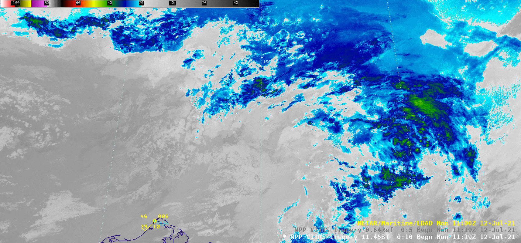
Figure: Suomi NPP VIIRS images showed thunderstorms over the Chukchi and Beaufort Seas off the northern coast of Alaska on July 12, 2021. Unusual aspects of the storms included their high latitude location over ice-covered waters — as far north as 75ºN latitude — and the numerous cloud-to-surface lightning strikes they produced. Read more at the CIMSS Satellite Blog: https://cimss.ssec.wisc.edu/satellite-blog/archives/41525. Credit: CIMSS.
OTHER:
| Archived Weeklies Page | Submit a report item |