[ Archive ]
| CIMSS-NOAA Weekly Report [ Archive ] |
CIMSS AND ASPB WEEKLY HIGHLIGHTS FOR THE WEEK ENDING JULY 30, 2021
PRODUCTS AND APPLICATIONS:
SNPP CrIS Side Switch: Cooperative Institute for Meteorological Satellite Studies (CIMSS) members of the NOAA Cross-track Infrared Sounder (CrIS) Sensor Data Records (SDR) team participated in efforts to restore functionality of the Longwave and Shortwave band observations from the Suomi National Polar-orbiting Partnership (SNPP) CrIS. Following the failure of the sensor's Side 2 Longwave band signal processor due to a Single event upset in May and the switch to the Side 1 electronics on July 12-13, various tuning and assessment efforts were conducted, leading to a successful Beta/Provisional Maturity Review on July 21 and the release of data to all users. The CIMSS efforts were critical in quickly determining that various calibration coefficients were optimal for the new configuration and demonstrating high quality data for retrieval, numerical weather prediction and other applications. (D. Tobin, CIMSS, 608-265-6281)
AWARDS AND RECOGNITION:
PUBLICATIONS:
Paper published on a blended sea ice concentration product: A manuscript titled "A Blended Sea Ice Concentration Product from AMSR2 and VIIRS" has been published in the journal Remote Sensing as part of a special issue on Polar Sea Ice: Detection, Monitoring and Modeling (https://doi.org/10.3390/rs13152982). Authors are Rich Dworak (Cooperative Institute for Meteorological Satellite Studies), Yinghui Liu and Jeff Key (STAR), and Walt Meier (University of Colorado). Using AMSR2 and VIIRS sea sce concentration (SIC) algorithms, a blended SIC product has been developed using the Best Linear Unbiased Estimator (BLUE) approach. Case studies and a multi-year comparison to ice concentration derived from Landsat data shows that the blended SIC produces lower error statistics relative to the individual products. Furthermore, the VIIRS Ice Surface Temperature (IST) algorithm is utilized to detect ice in melting and near-melting environments and to include this information in the blending. The scientific findings in this paper are that in melting sea ice environments, AMSR2 produces lower SIC compared to VIIRS and Landsat, and that the VIIRS SIC can be utilized by the blending technique to correct the bias observed in AMSR2 SIC for clear-sky conditions. (R. Dworak, CIMSS, 608-265-8620)
![]() (Click image to enlarge)
(Click image to enlarge)
Manuscript on cloud-depended background error covariance for data assimilation published in Monthly Weather Review: A Manuscript titled "Cloud-dependent piecewise assimilation based on a hydrometeor-included background error covariance and its impact on regional Numerical Weather Prediction" has been published in Monthly Weather Review (https://journals.ametsoc.org/view/journals/mwre/aop/MWR-D-20-0419.1/MWR-D-20-0419.1.xml). This study proposes a new cloud-dependent background error covariance strategy by adaptively adjusting the hydrometeor-included in the cloudy areas according to the cloud index (CI) derived from the geostationary satellite-based cloud products. The impact study on regional numerical weather prediction (NWP) demonstrates that the application of the cloud-dependent for data assimilation reduces analyses and forecasts bias and increases precipitation forecast skills. Diagnostics of a heavy rainfall case indicate that the application of the cloud-dependent enhances the moisture, wind, and hydrometeors analyses and forecasts, resulting in more accurate forecasts of accumulated precipitation. Jun Li, Cooperative Institute for Meteorological Satellite Studies (CIMSS) is a co-author. (Jun Li, CIMSS, Jun.Li@ssec.wisc.edu)
WORKSHOPS, CONFERENCES, AND MEETINGS:
Discussions with the OIG on the GeoXO Sounder: On July 29, T. Schmit and J. McCorkel (NASA/Goddard) answered a number of questions from the Office of the Inspector General (OIG). Most of the discussion involved the many GeoXO Sounder (GXS) related observing system simulation experiments (OSSEs), especially the recently published hybrid OSSE: https://link.springer.com/article/10.1007/s00376-021-0443-1. (T. Schmit, E/RA2, 608-263-0291, tim.j.schmit@noaa.gov)
TRAINING AND EDUCATION:
VISIT Teletraining on Mesoscale Convective Vortices: Scott Lindstrom from the Cooperative Institute for Meteorological Satellite Studies (CIMSS) gave a Virtual Institute for Satellite Integration Training (VISIT) webinar on Mesoscale Convective Vortices (MCVs) to the Science and Operations Officer (SOO) and the student volunteer for the National Weather Service office in Albuquerque NM. The training serves as a reminder on why knowledge of the structure and supporting environment for MCVs was important for nowcasting. (S. Lindstrom, CIMSS, 608 263 4425)
MEDIA AND OUTREACH:
SSEC and CIMSS Scientists in the News: Scientists at the University of Wisconsin-Madison (UW) Space Science and Engineering Center (SSEC) and the Cooperative Institute for Meteorological Satellite Studies (CIMSS) provide expert interviews, imagery and case studies to promote science. This week: 1. CIMSS scientist John Cintineo and NOAA scientist Mike Pavolonis are using artificial intelligence applications to predict where the GOES-R Geostationary Lightning Mapper will observe lightning in the future. Read more at NESDIS News: https://go.wisc.edu/826f53. 2. SSEC Honorary Fellow Jordan Gerth participated in a hearing on July 20, 2021 before the U.S. House of Representatives Committee on Science, Space and Technology on "Spectrum Needs for Observations in Earth and Space Sciences." https://www.youtube.com/watch?v=B5gIQNgOzEk&t=7363s. 3. CIMSS Satellite Blog contributors Scott Linstrom and Scott Bachmeier published case studies on "The Day Night Band and Smoke" (July 29), "Microwave rain estimates with an MCS" (July 29), "SAR winds near Tropical Storm Nepartak" (July 27), "Severe thunderstorms in northern Minnesota" (July 26), "Tropical Storm Nepartak approaches Japan" (July 26), and "Tropical disturbance off the US Southeast Coast" (July 25). Read more: https://cimss.ssec.wisc.edu/satellite-blog/. (J. Phillips, SSEC, 608-262-8164, J. Cintineo, CIMSS, M. Pavolonis, E/RA2, J. Gerth, SSEC, S. Lindstrom, CIMSS, S. Bachmeier, CIMSS)
 (Click image to enlarge)
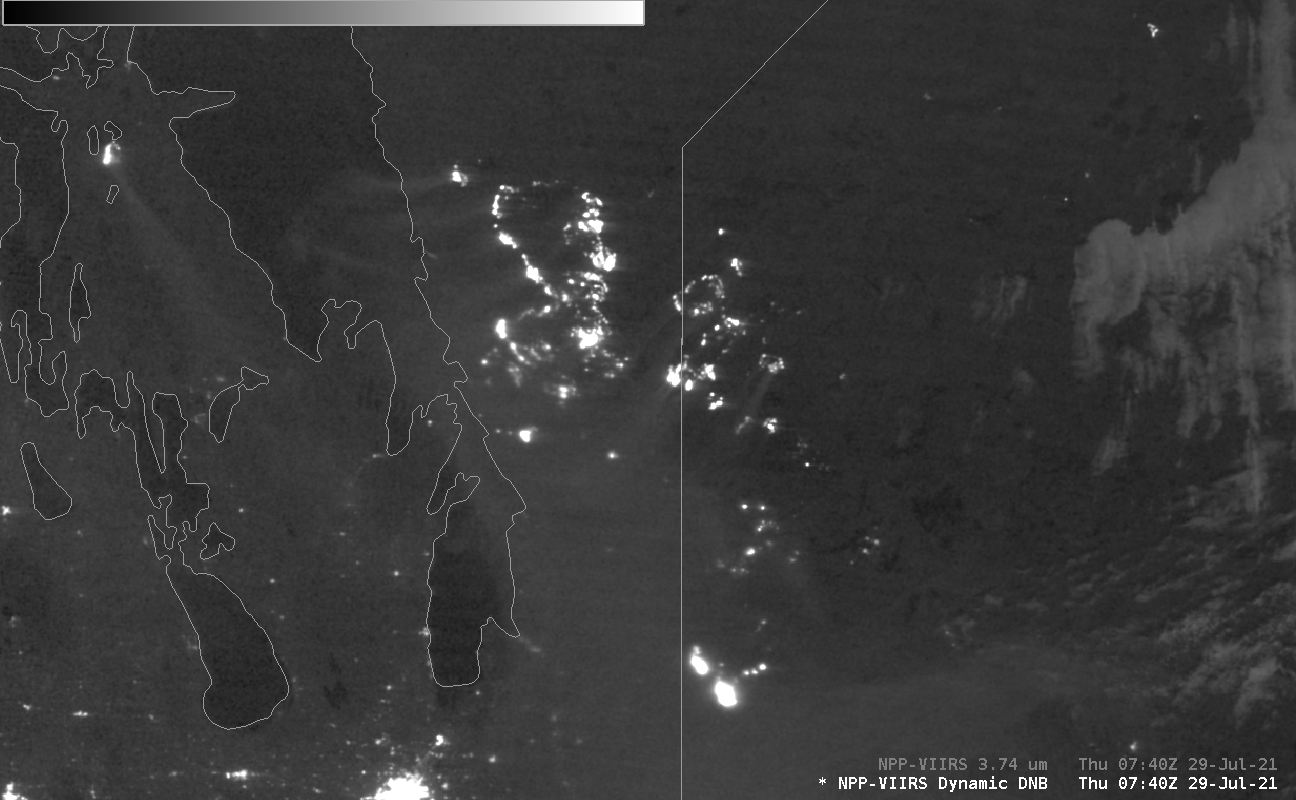
Figure: Bright signals apparent on Suomi NPP VIIRS Day/Night Band visible images show light emitted by active fires in Canada on July 29, 2021 along with their associated smoke. Read more at the CIMSS Satellite Blog: https://cimss.ssec.wisc.edu/satellite-blog/archives/41707.
 (Click image to enlarge)
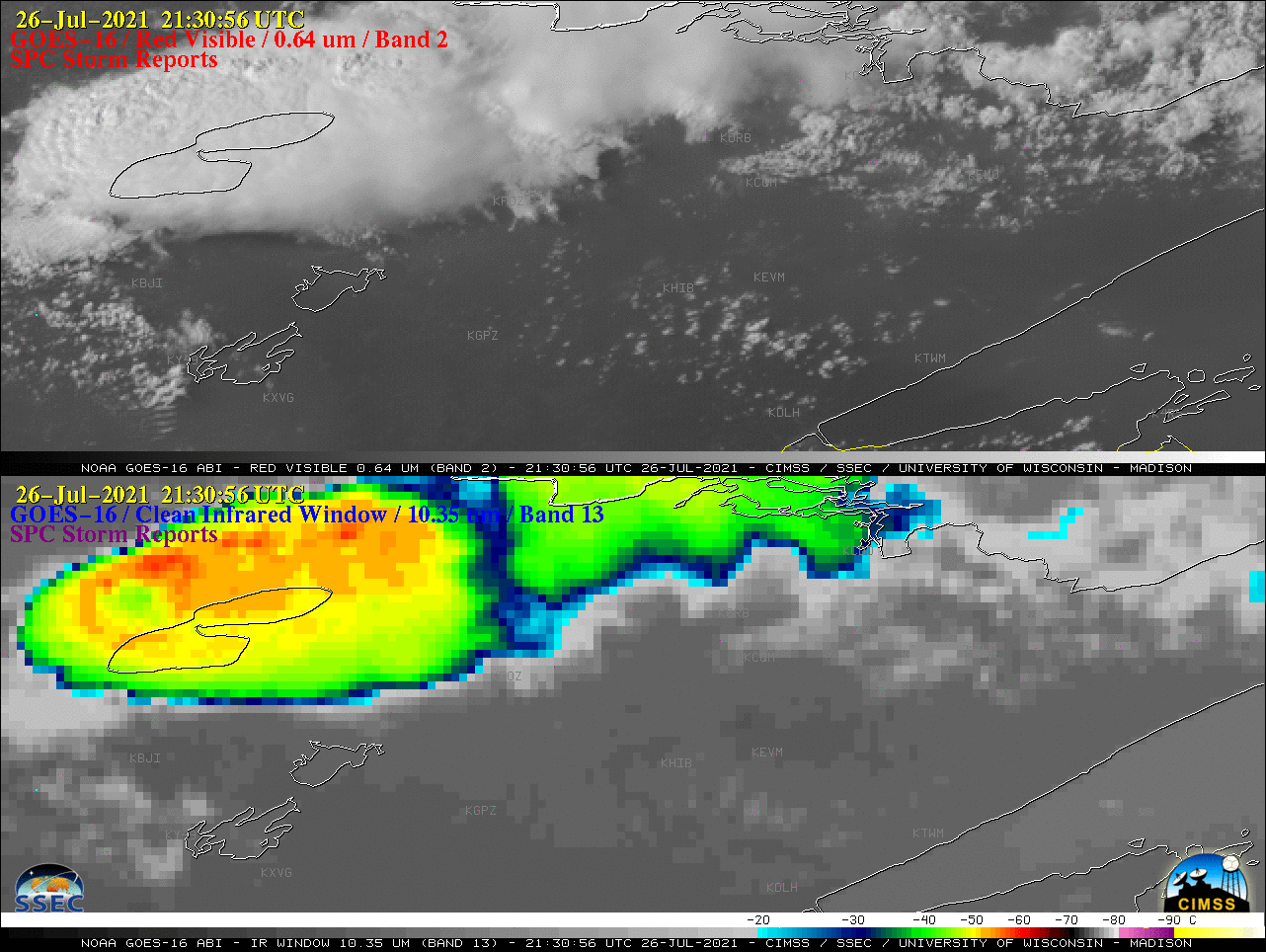
Figure: One–minute, GOES-16 images on July 26, 2021 captured supercell thunderstorms moving east-southeastward across Northern Minnesota. Storm reports included a tornado and hail up to 3 inches in diameter. Read the CIMSS Satellite Blog post: https://cimss.ssec.wisc.edu/satellite-blog/archives/41662. Credit: CIMSS, NOAA NWS Storm Prediction Center.
OTHER:
| Archived Weeklies Page | Submit a report item |