[ Archive ]
| CIMSS-NOAA Weekly Report [ Archive ] |
CIMSS AND ASPB WEEKLY HIGHLIGHTS FOR THE WEEK ENDING AUGUST 20, 2021
PRODUCTS AND APPLICATIONS:
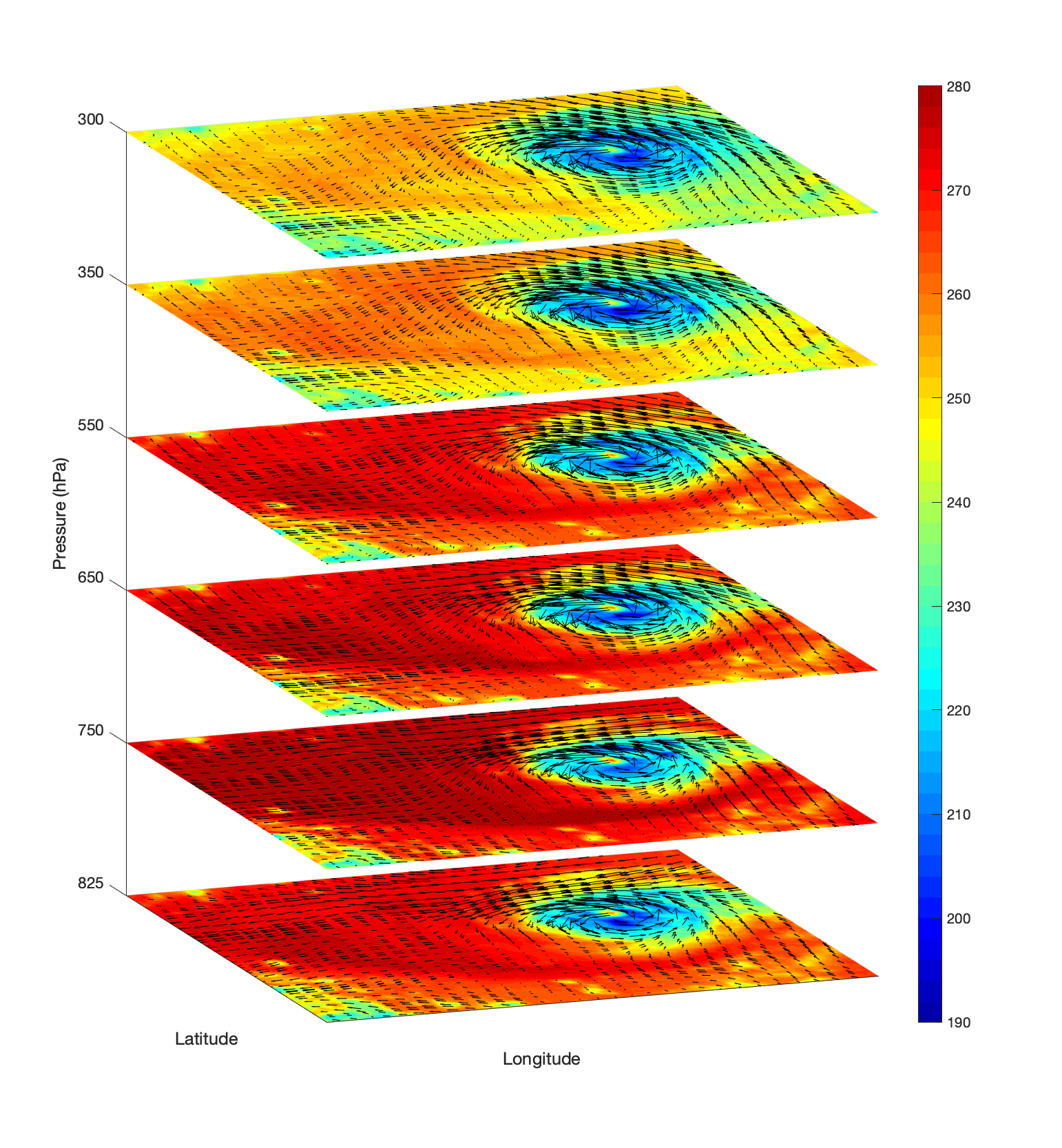
Sample 4D Data Cube based on High spectral/temporal IR data: At the request of the Geostationary Extended Observations (https://www.nesdis.noaa.gov/GeoXO) program, the Cooperative Institute for Meteorological Satellite Studies (CIMSS) generated a 4-Dimensional data cube based on the FY-4A Geostationary Interferometric Infrared Sounder (GIIRS) high spectral infrared / high temporal observations. The animation is for Typhoon Maria and shows water vapor Brightness Temperatures at different levels and the GIIRS derived winds: https://cimss.ssec.wisc.edu/satellite-blog/images/2018/03/Typhoon_Maria_2018071000_moisture_derived_winds_8sec.mp4. (Jun Li, CIMSS, 608-262-3755; T. Schmit, E/RA2, 608-263-0291, tim.j.schmit@noaa.gov)
 (Click image to enlarge)
Figure: A data cube showing water vapor Brightness Temperatures at different levels and the GIIRS derived winds every 15 min associated with Typhoon Maria (2018).
AWARDS AND RECOGNITION:
PUBLICATIONS:
Manuscript on all-sky infrared radiance assimilation published: A manuscript titled "Satellite All-sky Infrared Radiance Assimilation: Recent Progress and Future Perspectives" has been published in Advances in Atmospheric Sciences (http://www.iapjournals.ac.cn/aas/en/article/doi/10.1007/s00376-021-1088-9). The paper provides an overview of the progress on satellite-based infrared (IR) data assimilation in cloudy skies, discusses the remaining challenges, and provides future directions. Topics include indirect use of cloudy IR observations, especially the assimilation of hyperspectral cloud-cleared radiances, and direct assimilation of all-sky IR radiances. Co-authors are Jun LI (also the corresponding author, CIMSS/University of Wisconsin-Madison), Alan J. GEER (ECMWF), Kozo OKAMOTO (Meteorological Research Institute, Japan Meteorological Agency), Jason A. OTKIN (CIMSS/University of Wisconsin-Madison, Zhiquan LIU (NCAR), Wei HAN (National Meteorological Center of China Meteorological Administration), and Pei WANG (CIMSS/University of Wisconsin-Madison). Jun Li (CIMSS, Jun.Li@ssec.wisc.edu).
WORKSHOPS, CONFERENCES, AND MEETINGS:
NUCAPS Users' Working Group Presentation: Scott Lindstrom, from the Cooperative Institute for Meteorological Satellite Studies (CIMSS) gave a presentation on real-time uses of NOAA-Unique Combined Atmospheric Processing System (NUCAPS) data to the NUCAPS Users' Working Group (NUWG) during their semi-regular webinar series. The NUWG is organized by the JPSS Program and includes National Weather Forecasters and Science and Operations Offices (SOOs); it is led by Kris White, WFO Huntsville, and Chauncy Schultz, WFO Bismarck. The presentation was on two convective events over Wisconsin, detailed here (https://cimss.ssec.wisc.edu/satellite-blog/archives/41382) and here (https://cimss.ssec.wisc.edu/satellite-blog/archives/41845). NUCAPS data described the pre-convective environment and helped the short-term forecast. (S. Lindstrom, CIMSS, 608 263 4425)
TRAINING AND EDUCATION:
MEDIA AND OUTREACH:
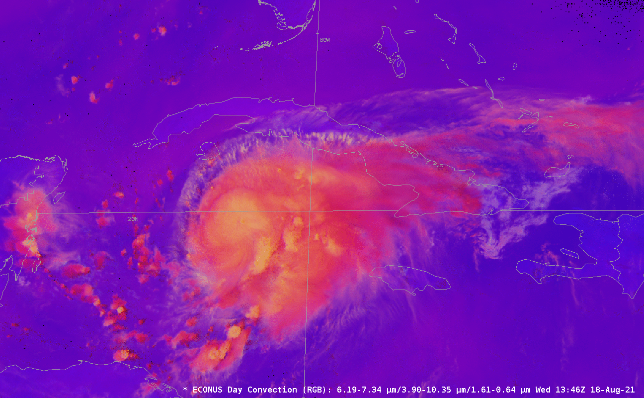
SSEC and CIMSS Scientists in the News: Scientists at the University of Wisconsin-Madison (UW) Space Science and Engineering Center (SSEC) and the Cooperative Institute for Meteorological Satellite Studies (CIMSS) provide expert interviews, imagery and case studies to promote science. This week: 1. SSEC Honorary Fellow Jim Kossin was interviewed for an E&E News story, "Scientists see old hurricane predictions coming true." Read more: https://www.eenews.net/articles/scientists-see-old-hurricane-predictions-coming-true/. 2. CIMSS Satellite Blog contributors Scott Lindstrom and Scott Bachmeier published case studies on "Hurricane Grace in the Caribbean" (Aug. 18), "Enhancing Smoke Detection with Red Visible imagery" (Aug. 18), "Calfor Fire in California" (Aug. 17), "Tropical Storm Henri near Bermuda" (Aug. 17), "Tropical Storm Fred makes landfall in Florida" (Aug. 16), "Overnight views of Tropical Storm Fred from NOAA-20 and Suomi-NPP" (Aug. 16), "Day 32 of the Dixie Fire in California, as viewed from 5 satellites" (Aug. 13), and "SIFT investigations of an EF-3 tornado that hit Boscobel, WI" (Aug. 13). Read more: https://cimss.ssec.wisc.edu/satellite-blog/. (J. Phillips, SSEC, 608-262-8164, J. Kossin, SSEC, S. Lindstrom, CIMSS, S. Bachmeier, CIMSS)
 (Click image to enlarge)
Figure: GOES-16 animation showing the Convection RGB over Grace on Aug. 18, 2021. Vigorous regions of convection are shown in orange and yellow. Read more at the CIMSS Satellite Blog: https://cimss.ssec.wisc.edu/satellite-blog/archives/42018. Credit: CIMSS, NOAA.
 (Click image to enlarge)
Figure: GOES-17 True Color RGB images on Aug. 17, 2021 showed smoke and frequent pyrocumulus clouds produced by the Caldor Fire in California. Read more at the CIMSS Satellite Blog: https://cimss.ssec.wisc.edu/satellite-blog/archives/42069. Credit: CIMSS, Geo2Grid.
OTHER:
| Archived Weeklies Page | Submit a report item |