[ Archive ]
| CIMSS-NOAA Weekly Report [ Archive ] |
CIMSS AND ASPB WEEKLY HIGHLIGHTS FOR THE WEEK ENDING SEPTEMBER 3, 2021
PRODUCTS AND APPLICATIONS:
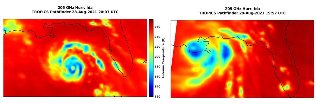
TROPICS Pathfinder Satellite Overflies Hurricane Ida: The NASA Time-Resolved Observations of Precipitation structure and storm Intensity with a Constellation of Smallsats (TROPICS) pathfinder satellite is the first in a constellation of low-Earth orbiters that will be launched next year. The pathfinder satellite was successfully launched in June and is now providing data to the processing team. Several overflights of Hurricane Ida were captured with examples in the accompanying figure. This data will be evaluated by the TROPICS science team in the coming months. (W. Blackwell, MIT-LL, C. Velden, UW-CIMSS, D. Herndon, UW-CIMSS, R. Bennartz, UW-SSEC)
 (Click image to enlarge)
Figure: Hurricane Ida captured by the TROPICS pathfinder satellite before (left) and after (right) landfall in Louisiana.
CIMSS supports response to Hurricane IDa: NOAA/NESDIS/JPSS, through the Cooperative Institute for Meteorological Satellite Studies (CIMSS), routinely provides FEMA and other partners access to the NOAA LEO/GEO flood products developed by Sanmei Li (GMU) both as actual GIS files for ingest into their systems and via a visualization website at CIMSS (https://www.ssec.wisc.edu/flood-map-demo/) and via briefing slides provided to FEMA. These products are utilized by both FEMA, NWS and other agencies in their response to Hurricane Ida to determine areas of urban flooding. For example, the downscaled (30m) VIIRS flood product was shown to be useful in indicating potential areas of urban flooding both in cities and in a couple industrial areas which were areas of interest, and is being evaluated for usage with urban search and rescue teams. Both the flood and power outage products provided by NOAA/JPSS have been well received during the daily remote sensing briefings that FEMA conducts. (W. Straka III, CIMSS;J. Hoffman, CIMSS)
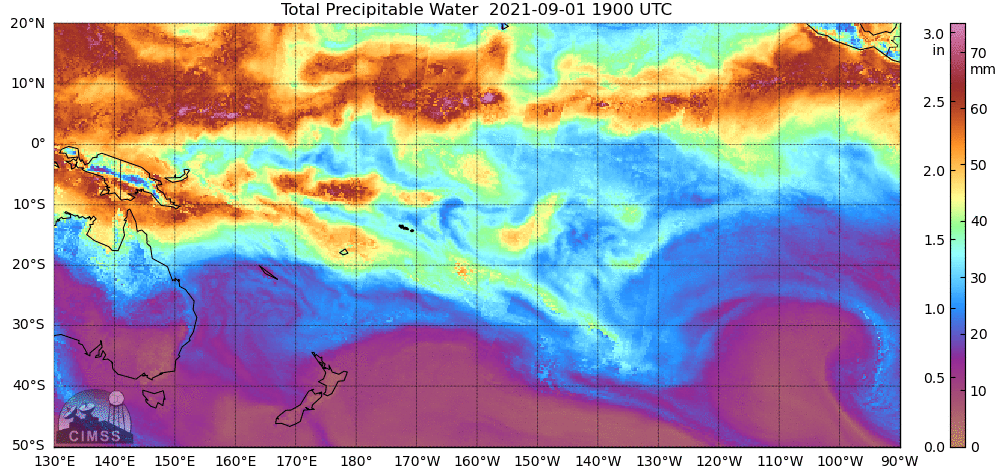
New MIMIC TPW Sector created for website: At the request of the National Weather Service Pacific Region Headquarters, Tony Wimmers from the Cooperative Institute for Meteorological Satellite Studies (CIMSS) has created a new MIMIC (Morphed Integrated Microwave Imagery at CIMSS) TPW (Total Precipitable Water) domain that is available online at http://tropic.ssec.wisc.edu/real-time/mtpw2/. This new 'South Pacific' domain is designed for the American Samoa forecast office in Pago Pago, American Samoa. (T. Wimmers, CIMSS, 608 263 3294; S. Lindstrom, CIMSS, 608 263 4425)
 (Click image to enlarge)
Figure: MIMIC Total Precipitable Water in the new South Pacific Domain for the 24 hours ending 1800 UTC on 2 September 2021.
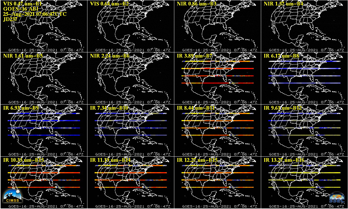
CIMSS Reports Missing ABI Imagery to CWG: Cooperative Institute for Meteorological Satellite Studies (CIMSS)at Wisconsin and NOAA/NESDIS Advanced Satellite Products Branch (ASPB) scientists noted blank images sent out from both Geostationary Operational Environmental Satellite (GOES)-16 Advanced Baseline Imager (ABI) and GOES-17 ABI in July and August. On August 6, 2021 at 11:59 UTC a blank GOES-17 full disk ABI image was sent out via GOES ReBroadcast (GRB) which was followed a minute later by a nominal GOES-17 full disk image. On multiple days in July and August GOES-16 sent out completely blank full disk images and/or an almost completely blank CONUS sector image over GRB. CIMSS reported these anomalies to the GOES-R Calibration Working Group (CWG) at their weekly meetings, inquired with NOAA/NESDIS Office of Satellite and Product Operations (OSPO) if it could be avoided to not distribute blank imagery over GRB, and sparked a discussion on the causes and potential solutions. For GOES-17, the August 6, 2021 11:59 UTC blank image was caused by an erroneous timeline glitch related to switching between the nominal Mode 6 timeline and the Mode 3 Cooling Timeline and was subsequently fixed by OSPO before the next day. For GOES-16 the blank images are being investigated by OSPO and seem to be related to a star tracker issue related to a particular star (star 1074) and OSPO continues to investigation. (M. Gunshor, CIMSS, T.Schmit E/RA2, 608-263-0291, tim.j.schmit@noaa.gov, J. Nelson, CIMSS)
 (Click image to enlarge)
Figure: GOES-16 ABI 16-panel CONUS sector image on August 25, 2021 at 07:06:47 UTC, likely the result of a star tracker anomaly.
AWARDS AND RECOGNITION:
PUBLICATIONS:
WORKSHOPS, CONFERENCES, AND MEETINGS:
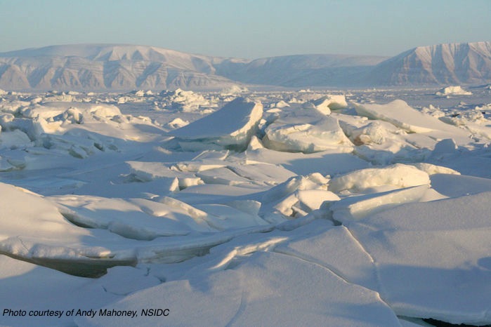
NOAA Cross Line Office Sea Ice Workshop: NOAA held a three-day, cross-line office (LO), virtual workshop focused on sea ice, 30 August - 1 September 2021. The purpose of the workshop was to capture and document specific sea ice needs and requirements in order to enhance current forecasting services and collaboration among the LO’s (NESDIS, NWS, OAR, NMFS, NOS). It addressed requirements for observing, modeling, and forecasting and how to align strategic plans across the LO’s. Rick Spinrad, NOAA Administrator, gave the keynote address. Jeff Key, Sean Helfrich, Eric Bayler, and Yinghui Liu (STAR) participated. Helfrich, Bayler, and Key led breakout sessions. The workshop report will be available in November. (J. Key, E/RA2, 608-263-2605, jeff.key@noaa.gov)
 (Click image to enlarge)
TRAINING AND EDUCATION:
VISITview teletraining software being phased out: After more than 20 years of use by instructors in the Virtual Institute for Satellite Integration Training (VISIT) to prepare and present interactive teletraining to National Weather Service (NWS) forecasters and international users alike, the VISITview software is being phased out as an operational toolkit. This was created by Tom Whittaker (Cooperative Institute for Meteorological Satellite Studies, CIMSS, now Emeritus) starting in 1998, with the encouragement and guidance from Scott Bachmeier and Scott Lindstrom (CIMSS) and staff at the Warning Decision Training Branch (WDTB), the Cooperative Institute for Research in the Atmosphere (CIRA), COMET, the European Organisation for the Exploitation of Meteorological Satellites (EUMETSAT) and others. The package evolved into a comprehensive toolkit to create, present and record highly interactive display of training materials mostly in support of the GOES program. VISITview was also used for real-time, interactive satellite-based weather briefings. While it is still used today to create presentations, VISITview is being replaced by commercial products for the teletraining. (T. Whittaker, CIMSS)
MEDIA AND OUTREACH:
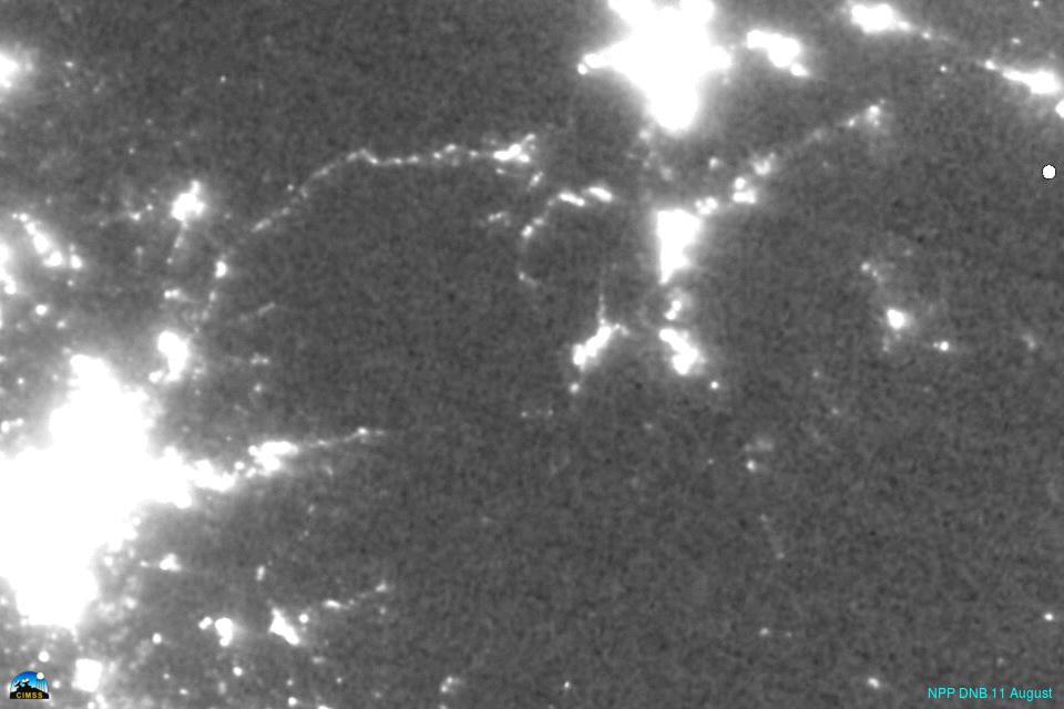
SSEC and CIMSS Scientists in the News: Scientists at the University of Wisconsin-Madison (UW) Space Science and Engineering Center (SSEC) and the Cooperative Institute for Meteorological Satellite Studies (CIMSS) provide expert interviews, imagery and case studies to promote science. This week: 1. CIMSS Satellite Blog contributors Scott Lindstrom and Scott Bachmeier published case studies on "Tropical Storm Larry in the far eastern Atlantic" (Sept. 1), "Caldor Fire approaches South Lake Tahoe" (Aug. 31), "Smoke plumes continue from Northern California wildfires" (Aug. 30-31), "Tropical Storm Kate loses convection" (Aug. 30), "Day Night Band imagery after Ida" (Aug. 30), "Hurricane Ida develops an eye over the Gulf of Mexico, as intensification continues until landfall" (Aug. 28-29), "Ida, Ascat and Turbulence" (Aug. 27). Read more: https://cimss.ssec.wisc.edu/satellite-blog/. (J. Phillips, SSEC, 608-262-8164, S. Lindstrom, CIMSS, S. Bachmeier, CIMSS)
 (Click image to enlarge)
Figure: Suomi NPP and NOAA-20 VIIRS Day Night Band imagery shows night-time snapshots of the Caldor Fire in California as it formed and moved towards Lake Tahoe in August 2021. Read more at the CIMSS Satellite Blog: https://cimss.ssec.wisc.edu/satellite-blog/archives/42293. Credit: CIMSS, SSEC VIIRS Today website.
 (Click image to enlarge)
Figure: GOES-17 True Color RGB images showed the diurnal variation of smoke from the Dixie, Caldor, and Tamarack fires in Northern California on Aug. 31, 2021. Read more at the CIMSS Satellite Blog: https://cimss.ssec.wisc.edu/satellite-blog/archives/42304. Credit: CIMSS, Geo2Grid.
OTHER:
| Archived Weeklies Page | Submit a report item |