[ Archive ]
| CIMSS-NOAA Weekly Report [ Archive ] |
CIMSS AND ASPB WEEKLY HIGHLIGHTS FOR THE WEEK ENDING SEPTEMBER 24, 2021
PRODUCTS AND APPLICATIONS:
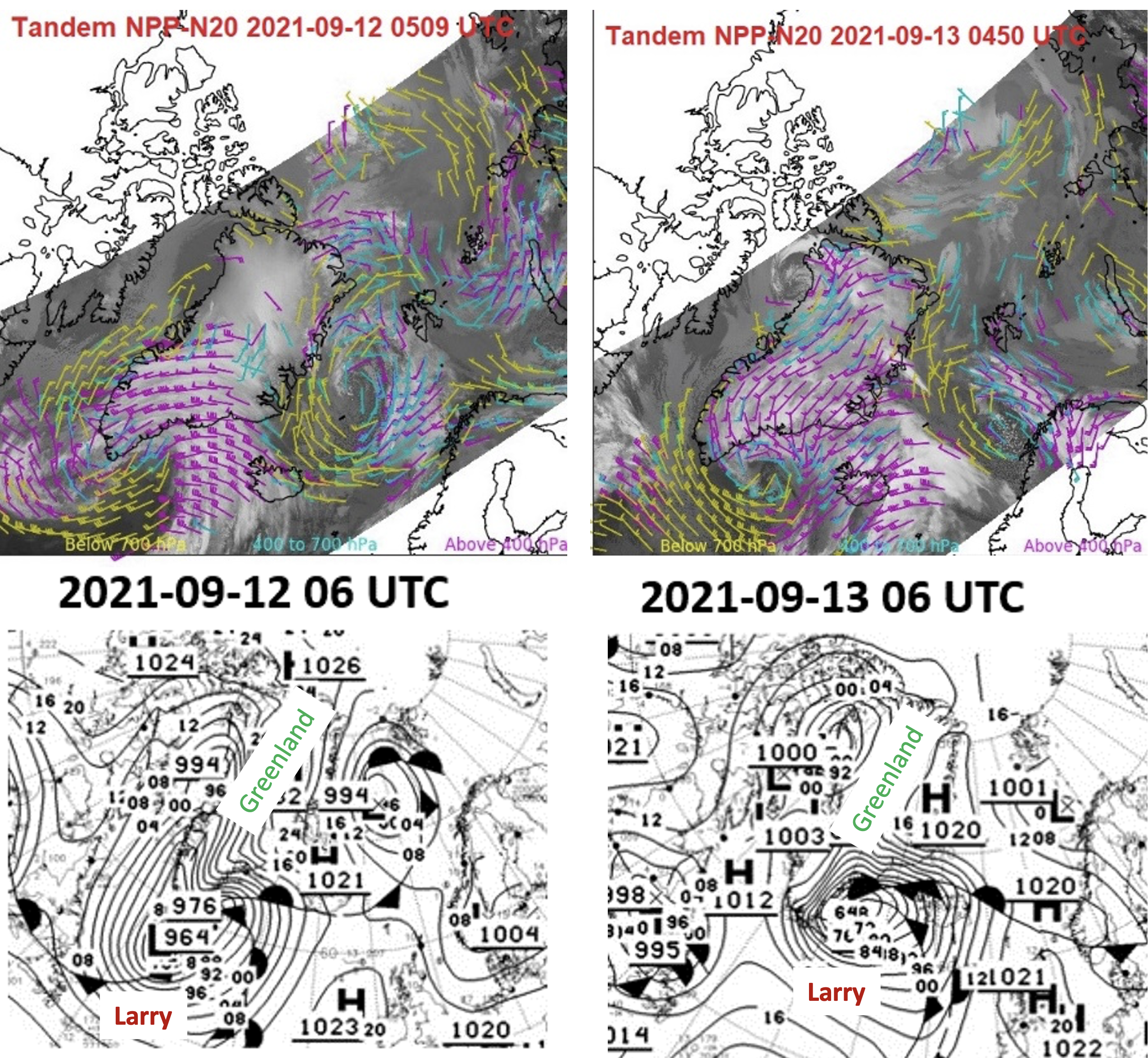
VIIRS Tandem Winds Product Tracks Post-Tropical Storm Larry: On 11 September 2021, Hurricane Larry moved to the northeast of Nova Scotia and transitioned into an extratropical storm (a class of post-tropical cyclone). By 12 September, Larry began merging with a sub-polar low-pressure system south of Greenland. On 13 September, the merged low-pressure system reached peak intensity with a central minimum low pressure of 964 mb off the southeast coast of Greenland. The VIIRS tandem winds product captured this progression well, as illustrated in the figure below for part of the multi-day event. The tandem winds product clearly illustrates the tight cyclonic motion associated with cloud features near the center of low pressure and the strong divergent flow in the left exit region of the jet streak between Iceland and Greenland. The significance of this case is that the VIIRS tandem winds product, which takes advantage of the fact that both S-NPP and NOAA-20 fly in the same orbit about 50 minutes apart, provides expanded latitudinal coverage over a single polar-orbiting satellite, extending the latitudinal range equatorward by 10 degrees or more. The event was covered in the mainstream media, e.g., https://cnn.it/3ub8VCv (CNN), https://wapo.st/3u7XLhI (Washington Post), and https://n.pr/3zBRpIv (NPR). (R. Dworak, CIMSS, 608-265-8620; J. Key, E/RA2, 608-263-2605, jeff.key@noaa.gov; D. Santek, CIMSS, 608-263-7410)
 (Click image to enlarge)
Figure: Top: VIIRS tandem winds atmospheric motion vectors on 12 and 14 September 2021 over the North Atlantic into the Arctic. Bottom: Corresponding surface weather analysis from the Ocean Prediction Center.
AWARDS AND RECOGNITION:
PUBLICATIONS:
WORKSHOPS, CONFERENCES, AND MEETINGS:
22nd International Ice Charting Working Group Meeting: The 22nd Meeting of the International Ice Charting Working Group (IICWG) was held virtually 20-24 September 2021. Since 1999, the IICWG has been a forum for the operational ice services around the world to discuss ways to better meet the needs of national and international maritime clients through coordination and cooperation in data sharing, standards, training, product development, and research activities. The IICWG is an advisory body to the World Meteorological Organization (WMO), and coordinates its activities with the WMO Executive Council Panel of Experts on Polar and High Mountain Observations, Research, and Services (EC-PHORS). The theme this year was “Ice Hazard Products and Services for Maritime Safety”. Jeff Key was a panelist on the topic of "Optimizing the mix of automated and manual products and processes for the best ice information services", where he promoted collaboration between STAR and the operational ice community in identifying user needs and satellite product and service solutions. (J. Key, E/RA2, 608-263-2605, jeff.key@noaa.gov)
![]() (Click image to enlarge)
(Click image to enlarge)
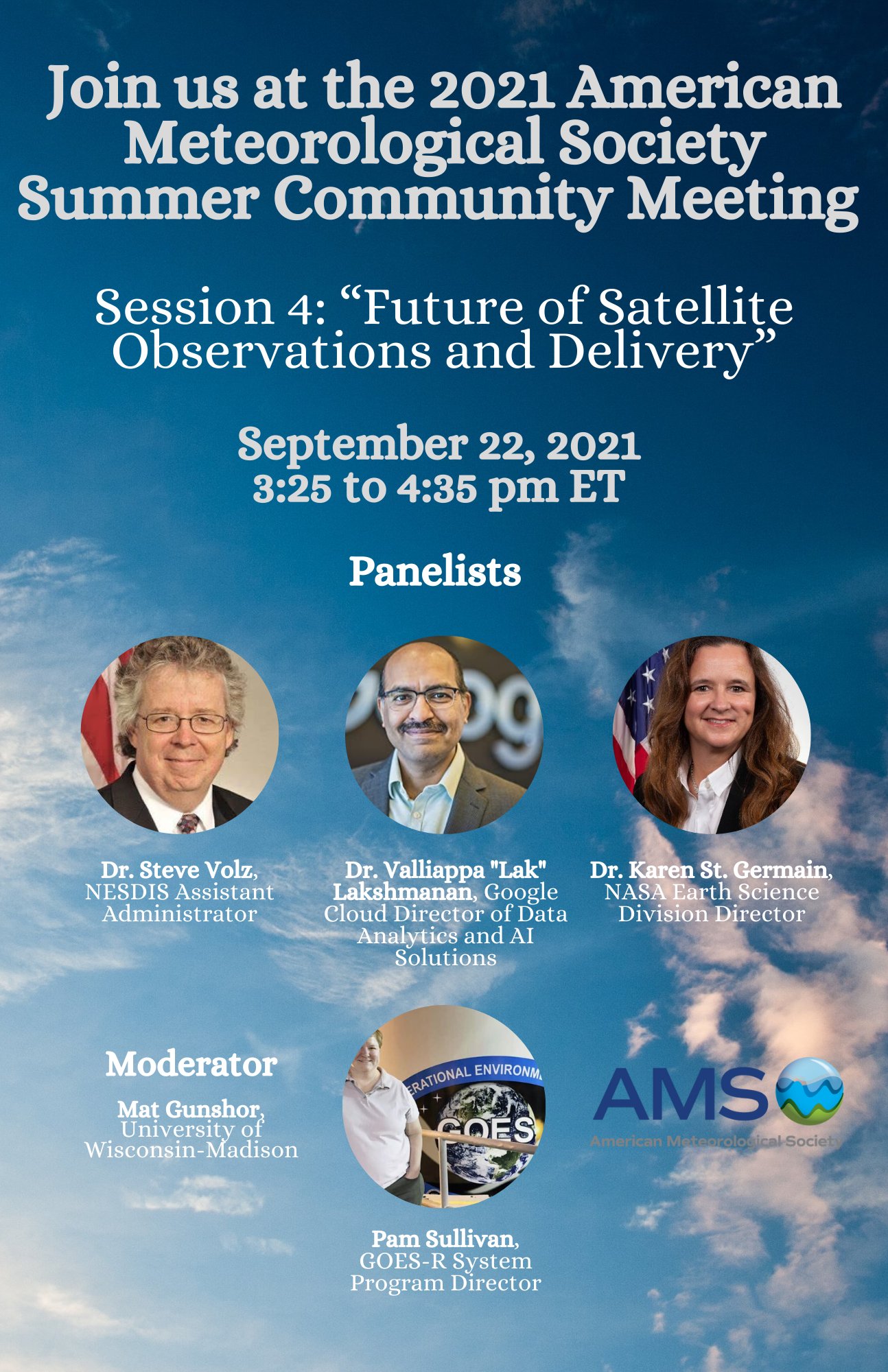
Participation in the AMS Summer Community Meeting: The annual American Meteorological Society (AMS) Summer Community Meeting (SCM) was held from 21-23 September, 2021. Mat Gunshor, Cooperative Institute of Meteorological Satellite Studies (CIMSS) at the University of Wisconsin-Madison, is serving on the AMS Board on Enterprise Communication (BEC), which is the planning committee for the SCM. In addition to help plan the meeting, Gunshor served as the moderator for a panel titled "Future of Satellite Observations and Delivery" with panel speakers: Dr. Valliappa "Lak" Lakshmanan, (Google Cloud Director of Data Analytics and AI Solutions), Dr. Karen St. Germain (NASA Earth Science Division Director), Dr. Pam Sullivan (GOES-R System Program Director), and Dr. Steve Volz (Assistant Administrator, Satellite and Information Service (NESDIS) and NOAA Acting Assistant Secretary for Environmental Observation and Prediction). (M. Gunshor, CIMSS, 608-263-1146).
 (Click image to enlarge)
Figure: AMS advertisement for the 2021 Summer Community Meeting satellite observations panel.
TRAINING AND EDUCATION:
CIMSS Presentation at GOES-R Hackathon: Scott Lindstrom from the Cooperative Institute for Meteorological Satellite Studies (CIMSS) presented a one-hour lecture on radiation (the electromagnetic spectrum) and satellite basics (including orbits, instruments, and parallax); these introductory topics were for students who are participating in the first-ever GOES-R Hackathon, an event sponsored by the GOES-R Office (https://www.goes-r.gov/users/hackathon.html). Participants in the webinar were undergraduate students in any academic major from NOAA Center for Earth System Sciences and Remote Sensing Technologies (CESSRST) institutions. This was the first of five lectures for the students. (S. Lindstrom, CIMSS, 608 263 4425)
Forecaster Training at DMH in Myanmar, Final Week: Scott Lindstrom from the Cooperative Institute for Meteorological Satellite Studies (CIMSS) completed the final of two weeks of remote instruction to staff of the Department of Meteorology and Hydrology (DMH) of the country of Myanmar. Topics for week 2 included Satellite imagery, rain and flooding detection, scatterometry, and mesoscale convective systems. The flipped classroom required students to view recorded videos beforehand; in-person Zoom-meeting time with the instructor was dedicated to review and questions. The training is funded by the World Meteorological Organization (WMO) through the University Corporation for Atmospheric Research (UCAR)'s COMET program. (S. Lindstrom, CIMSS, 608 263 4425)
MEDIA AND OUTREACH:
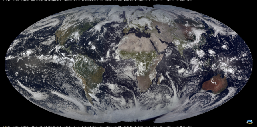
SSEC and CIMSS Scientists in the News: Scientists at the University of Wisconsin-Madison (UW) Space Science and Engineering Center (SSEC) and the Cooperative Institute for Meteorological Satellite Studies (CIMSS) provide expert interviews, imagery and case studies to promote science. This week: 1. A collaboration between SSEC and the Joint Center for Satellite Data Assimilation is aimed at inclusion of a geostationary HIS, or GeoHIS, on US satellites in the future in order to better predict and track high-impact weather. Read more: https://www.ssec.wisc.edu/news/articles/13908/. 2. A new flash drought intensity index developed by CIMSS Scientist Jason Otkin, along with researchers at other agencies, aims to clarify what a flash drought is and to better quantify its severity. Read more: https://www.ssec.wisc.edu/news/articles/13883/. 3. CIMSS Satellite Blog contributors Scott Lindstrom and Scott Bachmeier published case studies on "Sam in the Atlantic" (Sept. 23), "Rope cloud feeding into Tropical Invest 98L" (Sept. 22), "Sheared Tropical Storm Peter" (Sept. 20), "Local Noon imagery near the Equinox" (Sept. 19), and "Eruption of the Cumbre Vieja volcano in the Canary Islands" (Sept. 19). Read more: https://cimss.ssec.wisc.edu/satellite-blog/. (J. Phillips, SSEC, 608-262-8164, C. Bloch, CIMSS, R. Knuteson, SSEC, J. Otkin, CIMSS, S. Bachmeier, CIMSS, S. Lindstrom, CIMSS)
 (Click image to enlarge)
Figure: GOES-16 True Color RGB images showed a long rope cloud feeding into Tropical Invest 98L in the Eastern Atlantic Ocean on Sept. 22, 2021. More at the CIMSS Satellite blog: https://cimss.ssec.wisc.edu/satellite-blog/archives/42541. Credit: CIMSS, Geo2Grid.
 (Click image to enlarge)
Figure: This multi-satellite, true-color image, developed by SSEC/CIMSS scientists, was captured shortly before the Autumnal Equinox in the Northern Hemisphere and shows illumination at both poles. More at the CIMSS Satellite Blog: https://cimss.ssec.wisc.edu/satellite-blog/archives/42475. Credit: CIMSS, SSEC.
OTHER:
| Archived Weeklies Page | Submit a report item |