[ Archive ]
| CIMSS-NOAA Weekly Report [ Archive ] |
CIMSS AND ASPB WEEKLY HIGHLIGHTS FOR THE WEEK ENDING OCTOBER 1, 2021
PRODUCTS AND APPLICATIONS:
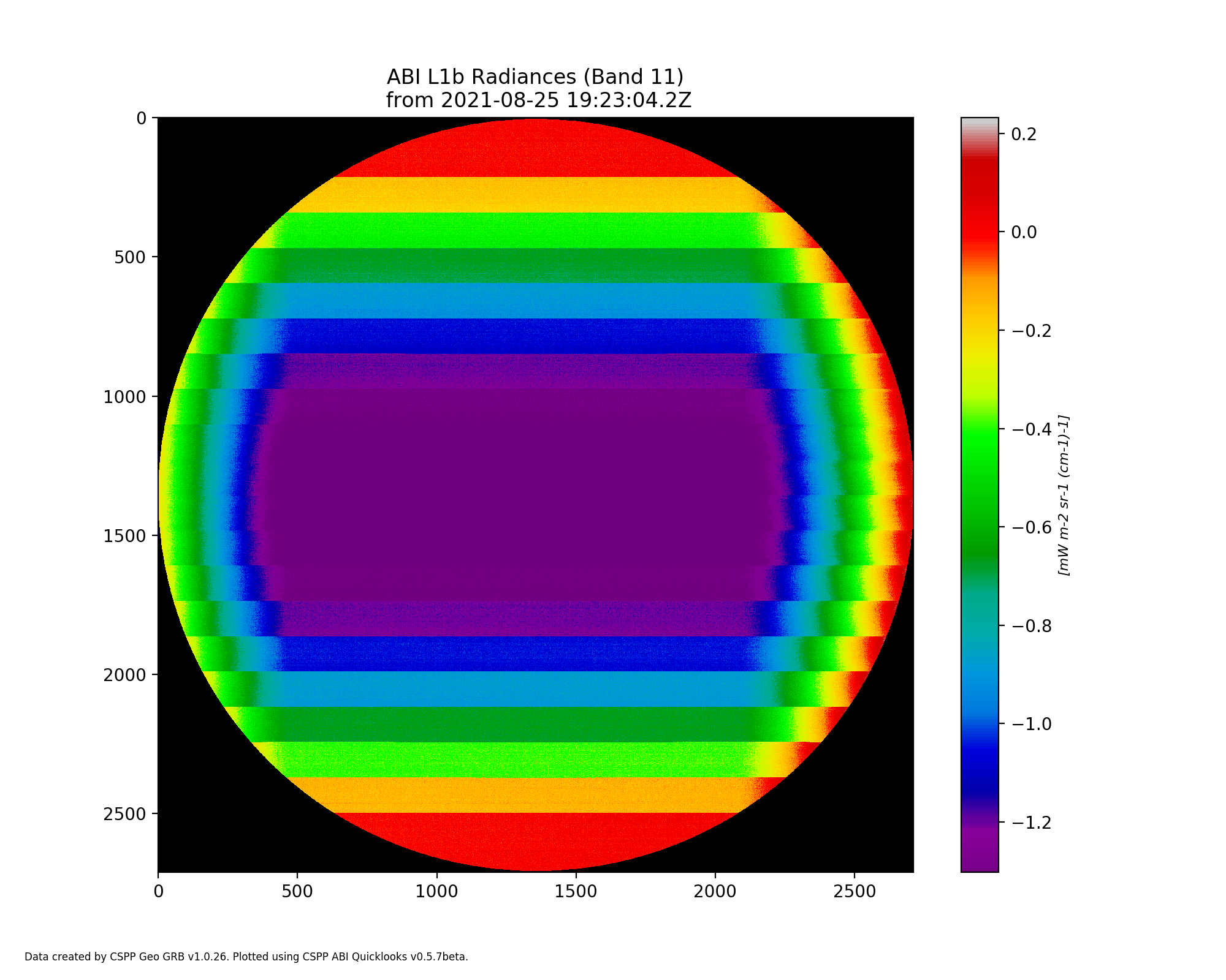
Testing of Simulated GOES-18 Interleaved GRB data in CSPP Geo Software: Simulated GOES-18 interleaved test data provided by the GOES-R Program was tested in Community Satellite Processing Package (CSPP) Geo software. A report was provided to the program to assist in evaluating the feasibility of the interleaving approach, which would allow distribution of GOES-18 ABI data on an accelerated schedule by mixing data from multiple satellites in a single GOES Rebroadcast (GRB) data stream. The test data was run through ingestor software that was developed at the Cooperative Institute for Meteorological Satellite Studies (CIMSS) and runs at a majority of GRB receive sites, in order to detect any potential issues with ground system configuration or CSPP Geo software. All provided test datasets were successfully processed, and no issues were found in data or software that would prevent successful processing of interleaved data at a user site. While this test involved offline testing of “canned” datasets, a second test is planned in the GOES-18 post-launch time frame, which will allow end-to-end testing of the full receiving and processing system using live GRB data received from GOES-18. (G. Martin, CIMSS, graemem@ssec.wisc.edu, N. Bearson, CIMSS, T. Jasmin, CIMSS)
 (Click image to enlarge)
Figure: Example GOES-18 ABI TVAC image from the interleaved data test, plotted with CSPP Geo quicklooks software.
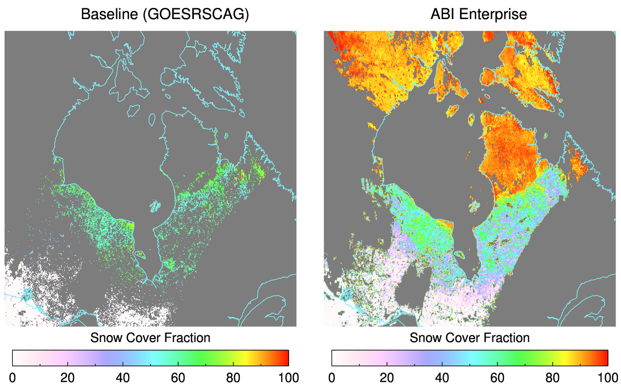
GOES-16/17 Snow Cover Products Provisional Review: The GOES-16 and GOES-17 Advanced Baseline Imager (ABI) level 2+ Fractional Snow Cover (FSC) Peer-Stakeholder Product Validation Review (P-SPVR) was held on 30 September 2021. The Provisional Maturity Review evaluated the status of the ABI Fractional Snow Cover product generated by the GOES-R Ground System and by ASSISTT (Algorithm Scientific Software Integration and System Transition Team). The Baseline algorithm FSC products were demonstrated to meet the accuracy (error bias) requirement, but did not pass the precision (standard deviation) requirement. This is possibly due to the Baseline algorithm (the GOES-R Snow Cover and Grain Size Algorithm, or GOESRSCAG) having difficulty characterizing scenes with very low and very high snow cover fraction. A replacement snow cover algorithm, which is an adaptation of the VIIRS Enterprise Fractional Snow Cover for ABI, was shown to improve accuracy and precision over the validation data and to meet the requirements. The science team recommended to the review board that this new algorithm become the Enterprise algorithm, i.e., the same core algorithm for both VIIRS and ABI, and that it transition to operations instead of the Baseline algorithm. Based on this recommendation and the validation data presented, the review board decided not to delaire the baseline FSC product as having reached Provisional Maturity, and that the transition of the Enterprise algorithm should be pursued. Engagement with snow cover product users and the reconciliation of the snow cover precision and accuracy requirements are necessary before establishing the maturity level of the new, adapted Enterprise snow cover algorithm for ABI. (A. Letterly, CIMSS, 608-890-1981; J. Key, E/RA2, 608-263-2605, jeff.key@noaa.gov; Y. Liu, E/RA2, 608-890-1893, yinghui.liu@noaa.gov)
 (Click image to enlarge)
Figure: The Baseline (GOESRSCAG) fractional snow cover output (left) over Hudson Bay and Northern Quebec on April 1, 2021. The adapted Enterprise algorithm for ABI shows a greater range in snow cover fraction values during the same time period. Cloudy pixels or water pixels are masked as gray, while clear snow-free pixels are white.
AWARDS AND RECOGNITION:
PUBLICATIONS:
WORKSHOPS, CONFERENCES, AND MEETINGS:
JPSS Ice Product Presentation to a NASA SPoRT team: Yinghui Liu of STAR/ASPB gave a presentation titled "Sea Ice Product Overview" to a NASA SPoRT (Short-Term Prediction Research and Transition) team led by Dr. Kevin Fuell of the University of Alabama in Huntsville. The presentation covers the algorithm basics, validation/calibration activities, weakness/strength, and applications of the sea ice products from JPSS VIIRS and GCOM-W1 AMSR2. The presentation will serve as part of the training content in a JPSS ice-products training micro-lesson for users. (Y. Liu, E/RA2, 608-890-1893, yinghui.liu@noaa.gov)
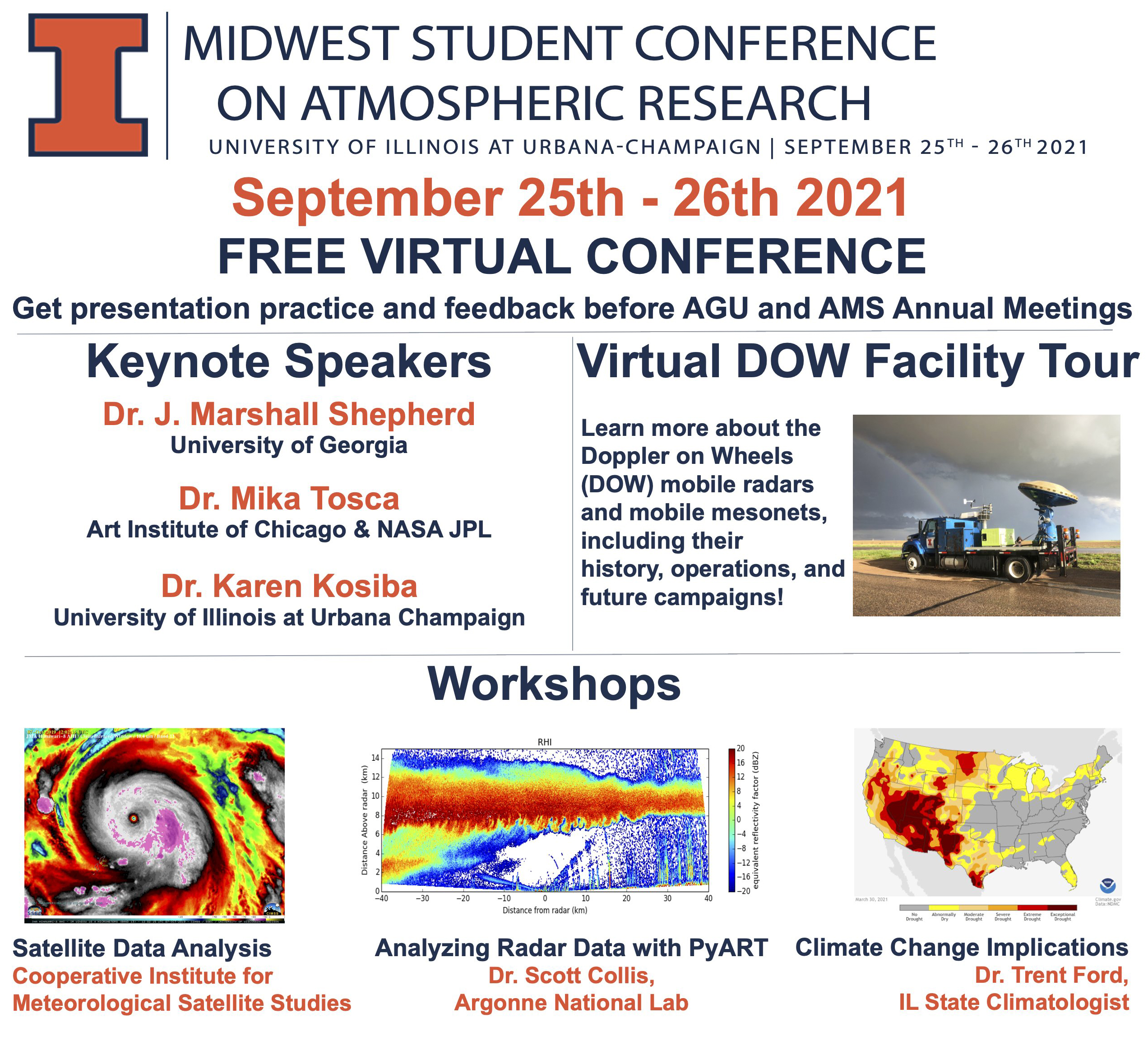
CIMSS Presentations at MSCAR: Scott Lindstrom and Margaret Mooney from the Cooperative Institute for Meteorological Satellite Studies (CIMSS) gave three remote presentations over 90 minutes at the Midwest Student Conference on Atmospheric Research (MSCAR: https://atmos.illinois.edu/mscar/), an annual (since 2017) conference organized by students at the Department of Atmospheric Sciences at the University of Illinois. Scott Lindstrom gave two presentations, one on atmospheric radiation and meteorological satellite basics, and one on data access and data display; Margaret Mooney presented on VIIRS imagery and applications before demonstrating how to access VIIRS from three websites: VIIRS Today (https://ge.ssec.wisc.edu/viirs-today) the new VIIRS Imagery Viewer (https://cimss.ssec.wisc.edu/viirs/imagery-viewer/) and JSTAR Mapper (https://www.star.nesdis.noaa.gov/jpss/mapper/). Mooney also invited MSCAR participants to coach a project in the JPSS/VIIIRS Virtual Science Fair this fall (https://cimss.ssec.wisc.edu/education/jpss/). The three presentations were followed by a question and answer session that centered on the utility of satellite data in the forecast process. (S. Lindstrom, CIMSS, 608 263 4425; M. Mooney, CIMSS)
 (Click image to enlarge)
Figure: Publicity Pamphlet for MSCAR.
TRAINING AND EDUCATION:
VISIT Training on NUCAPS Profiles: VISIT Training on NUCAPS Profiles: Scott Lindstrom from the Cooperative Institute for Meteorological Satellite Studies (CIMSS) gave a Virtual Institute for Satellite Integration Training (VISIT) session on NUCAPS (NOAA-Unique Combined Atmospheric Processing System) Profiles that are available in AWIPS at National Weather Service forecast offices. The training includes information on how individual profiles are created and displayed, how they can be modified in AWIPS, and on gridded thermodynamic fields that are derived from the NUCAPS profiles. This training was given to the Science and Operations Officer (SOO) in the Billings, MT forecast office (WFO BYZ) (S. Lindstrom, CIMSS, 608 263 4425)
MEDIA AND OUTREACH:
Judge for the GOES-R Hackathon: Tim Schmit from the NOAA/NESDIS Advanced Satellite Products Branch (ASPB) was a judge of the presentations by students who participated in the first-ever GOES-R Hackathon, an event sponsored by the GOES-R Office (https://www.goes-r.gov/users/hackathon.html). Undergraduate students of any academic major from NOAA Center for Earth System Sciences and Remote Sensing Technologies (CESSRST) institutions were eligible to participate. Six teams participated; each could select one of five challenge themes. (T. Schmit, E/RA2, 608-263-0291, tim.j.schmit@noaa.gov)
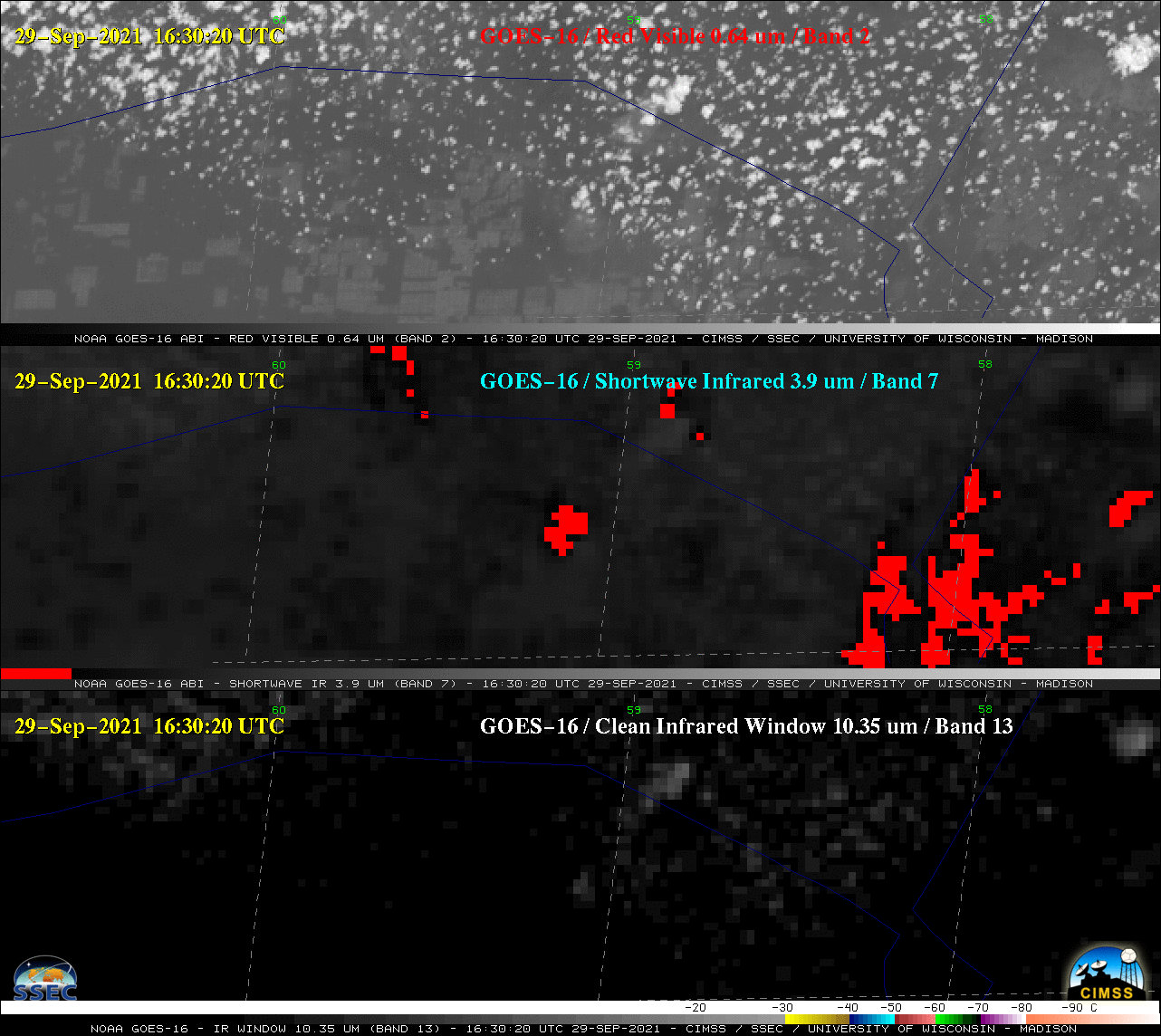
SSEC and CIMSS Scientists in the News: Scientists at the University of Wisconsin-Madison (UW) Space Science and Engineering Center (SSEC) and the Cooperative Institute for Meteorological Satellite Studies (CIMSS) provide expert interviews, imagery and case studies to promote science. This week: 1. SSEC News published this story on NOAA Experiential Research and Training Opportunities intern, Ronald Adomako, and his NOAA mentor, Tim Schmit: "Shark fins and internships – Solving real world problems through mentorship." Read more: https://www.ssec.wisc.edu/news/articles/13939/. 2. CIMSS Satellite Blog contributors Scott Lindstrom, Tim Schmit, and Scott Bachmeier published case studies on "Kilauea is active again" (Oct. 1), "GOES-17 Level 2 Products are flowing over the SBN" (Sept. 30), "Viewing NUCAPS profiles with Sharppy" (Sept. 29), "Pyrocumulonimbus cloud over northern Paraguay" (Sept. 29), "GOES-17 sees Landsat 9 Rocket Plume" (Sept. 28), "1985s Hurricane Gloria" (Sept. 27), "Hurricane Sam reaches Category 4 intensity" (Sept. 25), and "Ephemeral Theresa" (Sept. 25). Read more: https://cimss.ssec.wisc.edu/satellite-blog/. 3. A tweet by CIMSS scientist Scott Bachmeier about a GOES-16 view of a pyrocumulonimbus cloud over northern Paraguay was picked up by MetSul.com, a company that specializes in weather and climate information for South America. Read more: https://go.wisc.edu/k85781. (J. Phillips, SSEC, 608-262-8164, C. Bloch, CIMSS, T. Schmit, E/RA2, S. Bachmeier, CIMSS, S. Lindstrom, CIMSS)
 (Click image to enlarge)
Figure: Fires burning in northern Paraguay on Sept. 29, 2021 created a pyrocumulonimbus, or pyroCb cloud, as seen here by GOES-16. More at the CIMSS Satellite Blog: https://cimss.ssec.wisc.edu/satellite-blog/archives/42663. Credit: CIMSS.
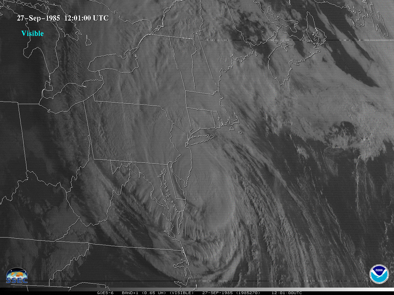 (Click image to enlarge)
Figure: A look back at the late-September 1985 landfall of Hurricane Gloria via GOES-6 visible imagery. More at the CIMSS Satellite Blog: https://cimss.ssec.wisc.edu/satellite-blog/archives/42614. Credit: CIMSS, NOAA.
OTHER:
| Archived Weeklies Page | Submit a report item |