[ Archive ]
| CIMSS-NOAA Weekly Report [ Archive ] |
CIMSS AND ASPB WEEKLY HIGHLIGHTS FOR THE WEEK ENDING OCTOBER 15, 2021
PRODUCTS AND APPLICATIONS:
AWARDS AND RECOGNITION:
PUBLICATIONS:
WORKSHOPS, CONFERENCES, AND MEETINGS:
TRAINING AND EDUCATION:
MEDIA AND OUTREACH:
SSEC and CIMSS Scientists in the News: Scientists at the University of Wisconsin-Madison (UW) Space Science and Engineering Center (SSEC) and the Cooperative Institute for Meteorological Satellite Studies (CIMSS) provide expert interviews, imagery and case studies to promote science. This week: 1. SSEC data scientist Iain McConnell is building a model using machine learning to help the National Weather Service understand its social media impact. SSEC News published this story: https://www.ssec.wisc.edu/news/articles/13975/. 2. CIMSS Satellite Blog contributors Scott Lindstrom, Tim Schmit and Scott Bachmeier published case studies on "Using NUCAPS to diagnose threats in a region of Enhanced/Moderate risk" (Oct. 13), "Alisal Fire in Southern California" (Oct. 12-13), "“Adrift” 1983 Hurricane (Raymond)" (Oct. 12), "Kompasu skirts to the north of Luzon" (Oct. 11), "Severe thunderstorms in the Southern Plains" (Oct. 10), and "Ongoing eruption of Cumbre Vieja (La Palma) in the Canary Islands" (Oct. 9). Read more: https://cimss.ssec.wisc.edu/satellite-blog/. (J. Phillips, SSEC, 608-262-8164, C. Bloch, CIMSS, Iain McConnell, SSEC, S. Lindstrom, CIMSS, T. Schmit, E/RA2, S. Bachmeier, CIMSS)
 (Click image to enlarge)
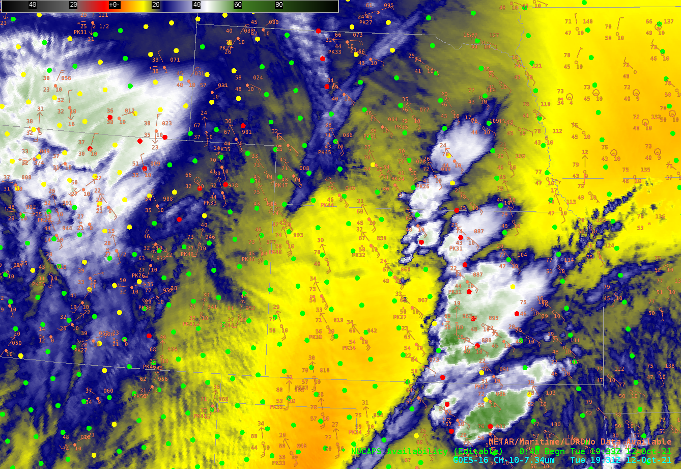
Figure: NOAA-20 NUCAPS Sounding Availability points are indicated as colored dots on this GOES-16 infrared image of low-level water vapor on Oct. 12, 2021. Read more at the CIMSS Satellite Blog: https://cimss.ssec.wisc.edu/satellite-blog/archives/42847. Credit: CIMSS, NOAA.
 (Click image to enlarge)
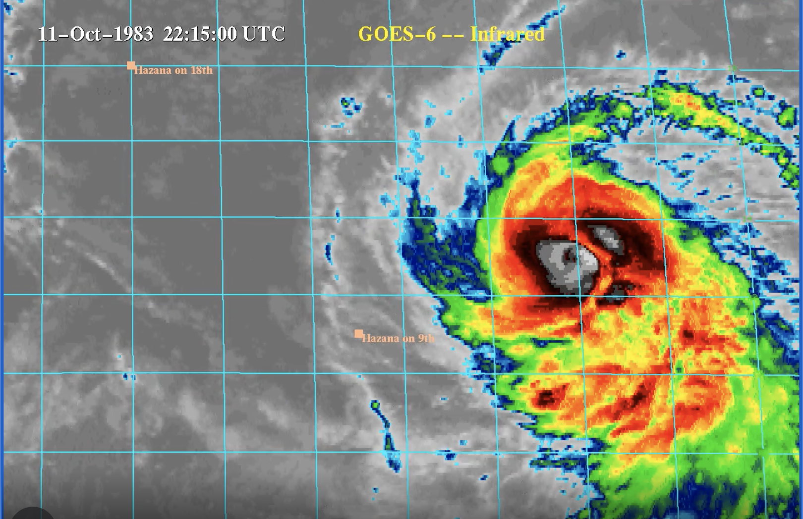
Figure: A look back at Hurricane Raymond in 1983 through NOAA 6 imagery and the vessel that was caught in its path. More at the CIMSS Satellite Blog: https://cimss.ssec.wisc.edu/satellite-blog/archives/41148. Credit: CIMSS, SSEC, NOAA.
OTHER:
CIMSS provides detailed SW WV analysis for GeoXO instrument studies: Scientists at the Cooperative Institute for Meteorological Satellite Studies (CIMSS) provided a report on benefits of using the short-wave side of the water vapor absorption band in geostationary imaging. The report was generated to provide scientific guidance to the Geostationary Extended Observations (GeoXO) project ahead of instrument design. The report was provided to Dr. Daniel Lindsey, the Geostationary Environmental Operational Satellite(GOES)-R Program Scientist, and Dr. Andrew Heidinger, the GeoXO project scientist. This work is also being submitted for peer-review in Earth and Space Science, with authors N. B. Miller, M. M. Gunshor, A. J. Merrelli, T. S. L’Ecuyer, and N.J. Gordillo from CIMSS, T. J. Schmit of NOAA/NESDIS, and J. J. Gerth of the National Weather Service (NWS). (M. Gunshor, CIMSS, 608-263-1146, T. Schmit, E/RA2, 608-263-0291, tim.j.schmit@noaa.gov)
| Archived Weeklies Page | Submit a report item |