[ Archive ]
| CIMSS-NOAA Weekly Report [ Archive ] |
CIMSS AND ASPB WEEKLY HIGHLIGHTS FOR THE WEEK ENDING OCTOBER 29, 2021
PRODUCTS AND APPLICATIONS:
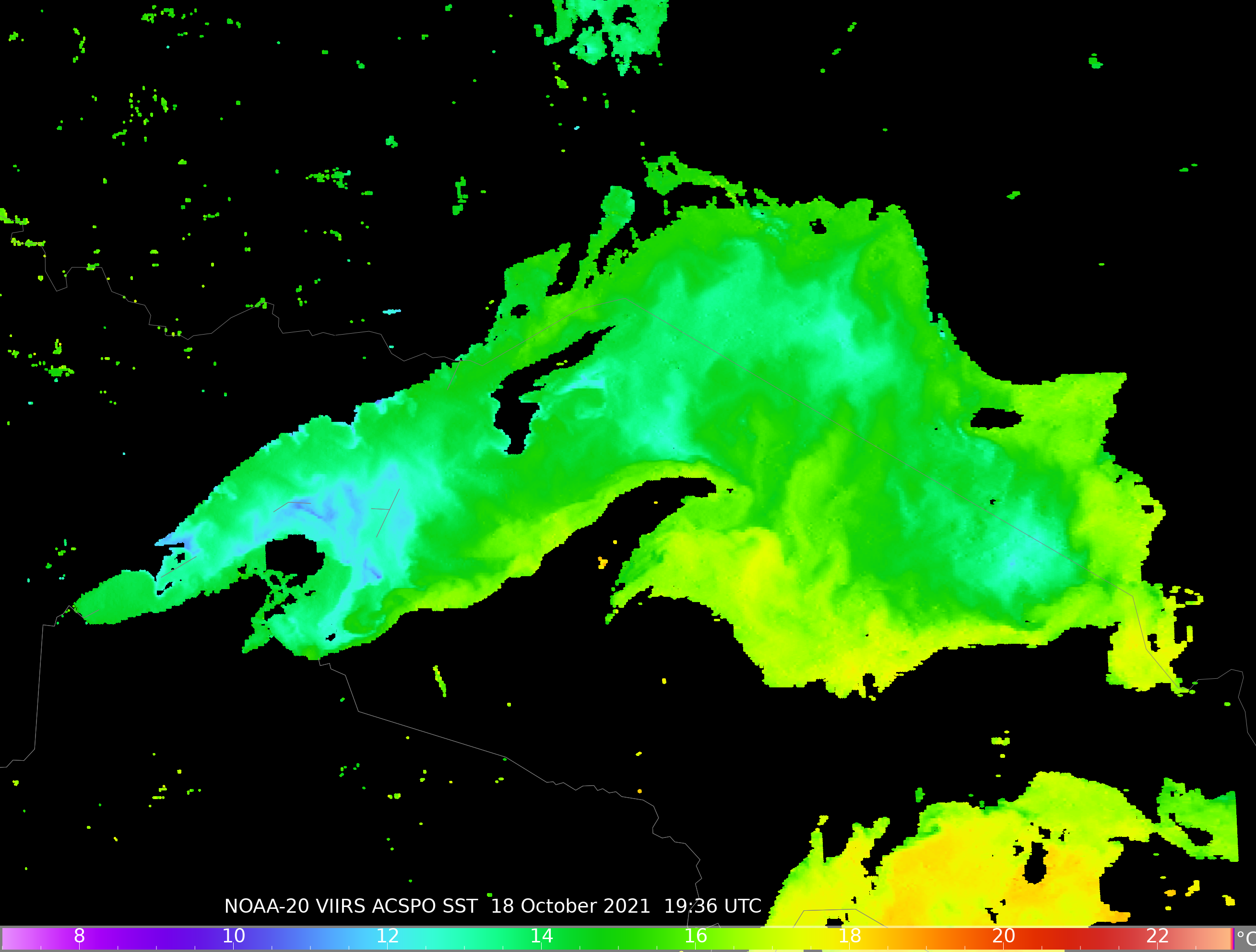
New CSPP ACSPO Sea Surface Temperature Software Released: The Community Satellite Processing Package (CSPP) team at the University of Wisconsin-Madison released a new version of the Advanced Clear-Sky Processor for Oceans (ACSPO) in support of the global direct broadcast community. ACSPO is the NOAA enterprise Sea Surface Temperature (SST) retrieval software and can create SSTs from Visible Infrared Imaging Radiometer Suite (VIIRS), Advanced Very High Resolution Radiometer (AVHRR) and Moderate Resolution Imaging Spectroradiometer (MODIS) imagers. This CSPP release (CSPP_ACSPO v2.0) is an implementation of NOAA ACSPO version 2.80. The CSPP global community includes more than 2800 registrants from 106 different countries with users on all 7 continents. CSPP is funded by the Joint Polar Satellite System (JPSS). Software can be freely downloaded through the CSPP website at https://cimss.ssec.wisc.edu/cspp/. (K. Strabala, CIMSS, 608-263-8752, J. Davies, SSEC)
 (Click image to enlarge)
Figure: NOAA-20 VIIRS SST image created using the new CSPP ACSPO Version 2.0 retrieval software. This image was created using direct broadcast data acquired on 18 October 2021 over Lake Superior.
AWARDS AND RECOGNITION:
PUBLICATIONS:
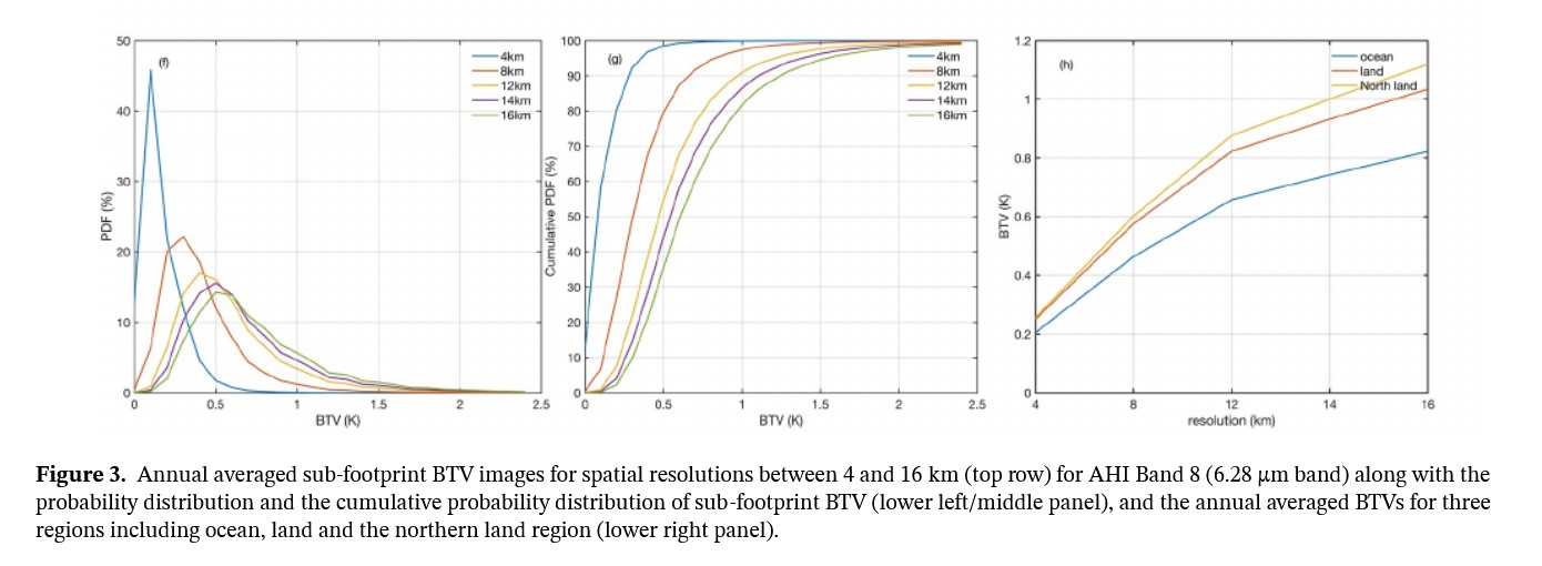
Paper Published in GRL on Sub-pixel Moisture : A paper ("Can Current Hyperspectral Infrared Sounders Capture the Small Scale Atmospheric Water Vapor Spatial Variations?") was published in Geophysical Research Letters. Higher spatial resolution infrared sounders provide more clear sky observations for data assimilation and other applications. And there is a significant increase in the annual clear footprint percentage when the spatial resolution is increased from that of the current sounders (12–16 km) to that of future sounders (4–8 km). The small scale moisture variations are better observed with higher spatial resolution as well. The paper authors are: Di, D., Li, J., Li, Z., Li, J., Schmit, T. J., & Menzel, W. P. More information: https://agupubs.onlinelibrary.wiley.com/doi/epdf/10.1029/2021GL095825. (T. Schmit, E/RA2, 608-263-0291; Z. Li, CIMSS, 608-890-1982)
 (Click image to enlarge)
Figure: Japan's Advanced Himawari Imager (AHI) Band 8 (6.3 µm band) along with the probability distribution and the cumulative probability distribution of sub-footprint brightness temperature variation (the maximum minus minimum within a footprint) (left/middle panel), and the annual averaged brightness temperature sub-pixel range for three regions including ocean, land and the northern land region (right panel).
WORKSHOPS, CONFERENCES, AND MEETINGS:
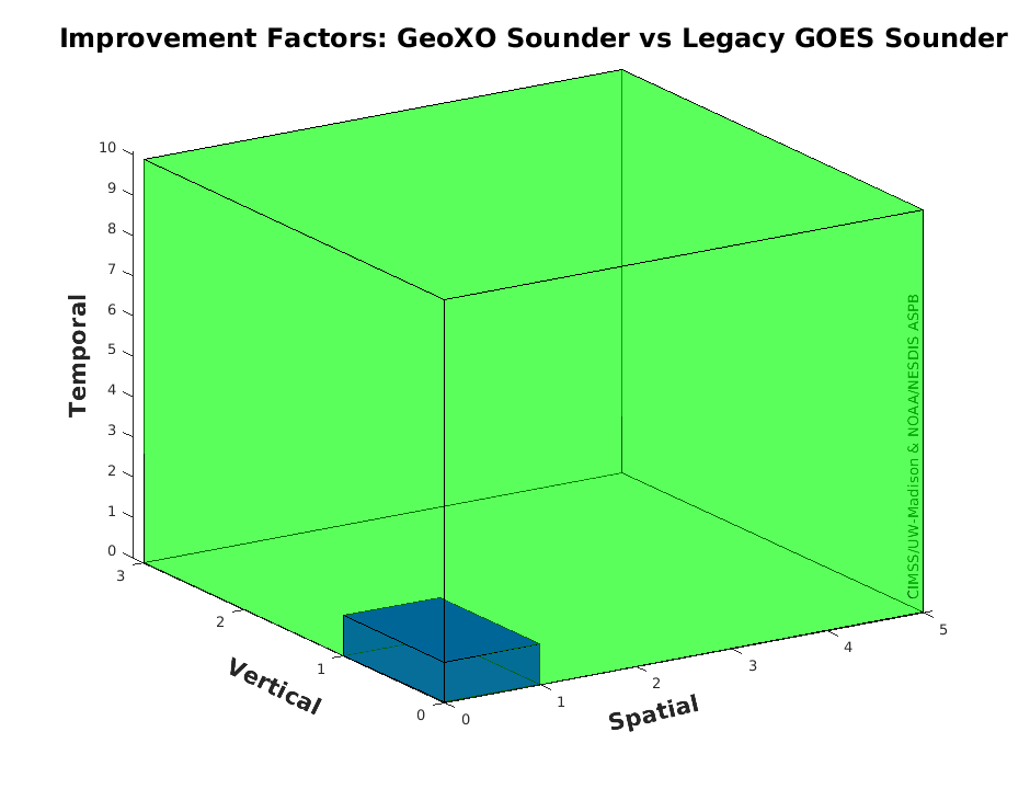
Presentation of the GOES-8/15 Class Sounders: On October 25, T. Schmit gave a presentation to the GEoXO Sounder (GXS) working group on the GOES legacy sounders. The legacy GOES (-8/15) sounders were used operationally in many ways, including both nearcasting (total precipitable water, atmospheric instability, clouds, and winds) and Numerical Weather Prediction (NWP): global and regional. There were also many uses of non-operational sounder products. The information content (spectral, temporal, spatial) from future advanced geostationary sounders will be so large compared to legacy (broadband) geostationary infrared sounders, that it dwarfs the capability of the legacy operationally used broad spectral band sounders. The presentation is available upon request. (T. Schmit, E/RA2, 608-263-0291)
 (Click image to enlarge)
Figure: The GeoXO Sounder (GXS) would be improved over the legacy GOES sounder on the order of 3 times the vertical resolution, 5 times the spatial resolution, and 10 times the temporal resolution.
TRAINING AND EDUCATION:
Training on NOAA Flood product at AOMSUC-11 Training Event: In support of the 11th Asia-Oceania Meteorological Satellite Users'Conference (AOMSUC-11), which was hosted by CMA, William Straka (CIMSS/SSEC, NOAA/JPSS) remotely presented on "Introduction and Demonstration of the NOAA Global Flood Product" NOAA Flood product Training Event, which is conducted prior to the conference, on 29 October 2021 (UTC, evening 28 October US time). The presentation encompassed an overview of the NOAA LEO/GEO flood product, which was developed at George Mason University and currently runs at CIMSS, as well as a demo of the "NOAA Satellite Proving Ground Global Flood Website" (https://www.ssec.wisc.edu/flood-map-demo/). This serves as an opportunity for outreach to countries in the Asia-Oceania region, where flooding is a consistent problem, especially during the monsoon season. (W. Straka, CIMSS; J. Hoffman, CIMSS; M. Goldberg, NOAA/NESDIS)
MEDIA AND OUTREACH:
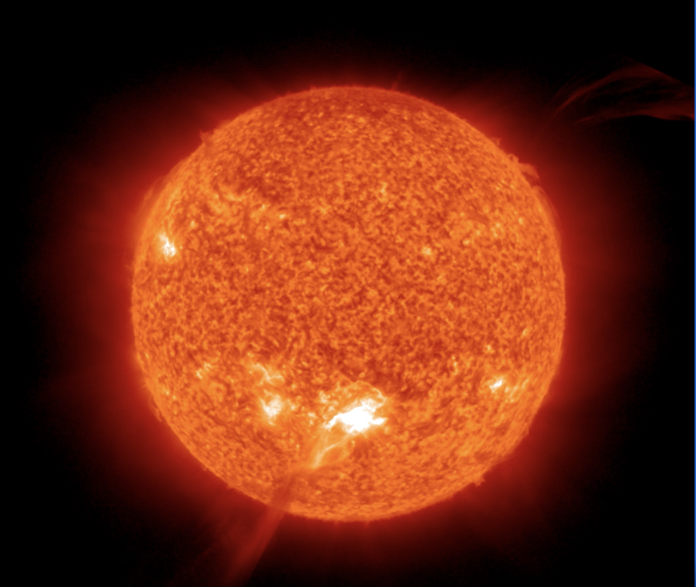
SSEC and CIMSS Scientists in the News: Scientists at the University of Wisconsin-Madison (UW) Space Science and Engineering Center (SSEC) and the Cooperative Institute for Meteorological Satellite Studies (CIMSS) provide expert interviews, imagery and case studies to promote science. This week: 1. James P. Kossin received the NOAA Administrator’s Award "for pioneering advancements in the understanding of hurricanes through the publication and communication of ground-breaking research and innovation." The award may go to an individual or a group in recognition of significant contributions to NOAA programs. 2) CIMSS Satellite Blog contributors Alexa Ross, Scott Bachmeier, Scott Lindstrom and Tim Schmit published these case studies: "Solar Flare detected by GOES Solar Ultraviolet Imager (SUVI) telescope" (Oct. 28), "Severe Weather in the Southeast United States (Oct. 27), "Severe thunderstorms across Missouri and Illinois" (Oct. 24), "Moisture returns to the US West Coast" (Oct. 22), and "Meteorologists Monitor Meteor" (Sept. 29). Read more: https://cimss.ssec.wisc.edu/satellite-blog/. (J. Phillips, SSEC, 608-262-8164, J. Kossin, A. Ross, SSEC, S. Bachmeier, CIMSS, S. Lindstrom, CIMSS, T. Schmit, E/RA2)
 (Click image to enlarge)
Figure: An X1 solar flare on Oct. 28, 2021 was detected by the GOES Solar Ultraviolet Imager. Read more about this space weather event at the CIMSS Satellite Blog: https://cimss.ssec.wisc.edu/satellite-blog/archives/43009. Credit: CIMSS, NOAA.
 (Click image to enlarge)
Figure: A MIMIC (Morphed Integrated Microwave Imagery at CIMSS) Total Precipitable Water rocking animation shows the development of a ribbon of moisture that moved into the northwestern United States starting on Oct. 11, 2021 until Oct. 21, 2021. Read more at the CIMSS Satellite Blog: https://cimss.ssec.wisc.edu/satellite-blog/archives/42949. Credit: CIMSS.
OTHER:
| Archived Weeklies Page | Submit a report item |