[ Archive ]
| CIMSS-NOAA Weekly Report [ Archive ] |
CIMSS AND ASPB WEEKLY HIGHLIGHTS FOR THE WEEK ENDING NOVEMBER 12, 2021
PRODUCTS AND APPLICATIONS:
AWARDS AND RECOGNITION:
PUBLICATIONS:
Geostationary Advanced Sounder Value Assessment Report Published: The Geostationary and Extended Observations (GeoXO) Hyperspectral InfraRed Sounder (GXS) Value Assessment Report was published as a NOAA/NESDIS Technical Report. The report is over 100 pages, covering the science, the need, potential applications and economic impacts. There are over 40 authors. The report can be found at https://doi.org/10.25923/7zvz-fv26. (T. Schmit, E/RA/2)
 (Click image to enlarge)
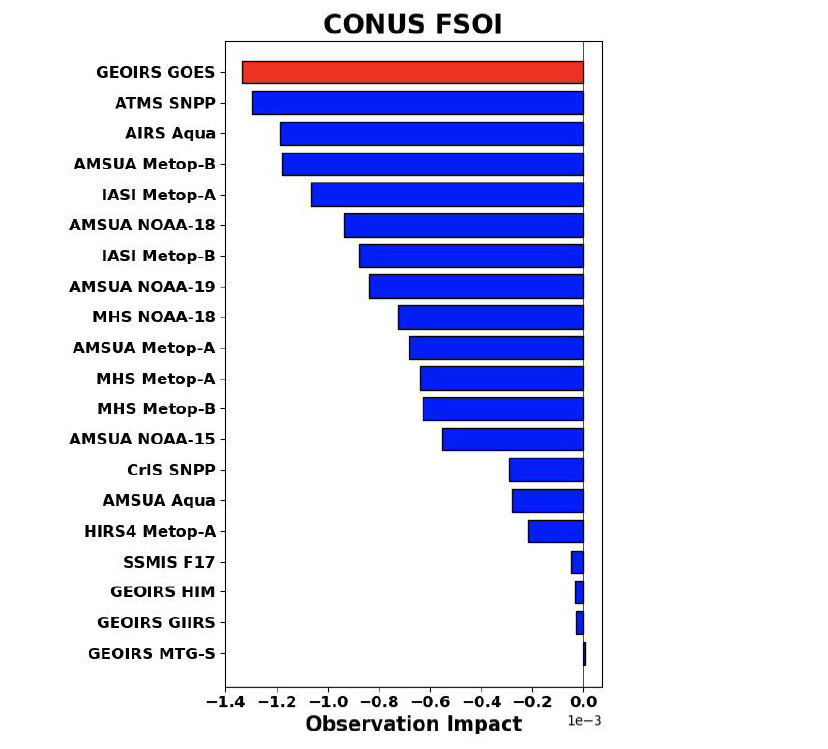
Figure: The Forecast Sensitivity Observation Impact (FSOI) is estimated from the CONUS region only and averages results from the 00, 06, 12, and 18 UTC cycles. This shows that the advanced infrared sounder over the central U.S. would provide the greatest impact. FSOI is a metric for all satellite radiance types by instruments and is a quantification on how each observation acts to reduce or increase the 24-hour forecast error of a selected norm.
Paper Describing Global Flash Drought Characteristics Published: A manuscript entitled “Global distribution, trends, and drivers of flash drought occurrence” by Jordan Christian (Univ. of Oklahoma) et al. was published in the November issue of Nature Communications. J. Otkin was a co-author of this study that used model reanalyses from 1980-2015 to examine the global distribution of flash droughts characterized by a period of rapid intensification over sub-seasonal time scales. The study identified global hotspots for flash drought occurrence using anomalies in evaporative stress. The study showed that notable flash drought hotspots exist around the world, with important differences in their seasonal characteristics and decadal trends noted. Research is needed to further our understanding of the regional drivers of flash drought and the interactions between flash drought and socioeconomic impacts. (J. Otkin, CIMSS, 608-265-2476)
Paper Describing Midwestern U.S. Drought Climatology Published: A manuscript entitled “Characteristics and predictability of Midwestern United States drought” by Andrew Hoell (NOAA Physical Sciences Laboratory) and co-authors was published in the November issue of the Journal of Hydrometeorology. J. Otkin was a co-author of this study that examined local and regional characteristics of drought across the Midwestern U.S. from 1916-2015 using output from land surface models. Regional drought differences were closely related to the seasonal cycle in precipitation, resulting in a higher likelihood of drought onset or demise during wet seasons. Drought was more likely to persist for longer periods across climatologically drier regions. It was also shown that drought variability was related to atmospheric wave trains spanning the Pacific-North America sector. (J. Otkin, CIMSS, 608-265-2476)
WORKSHOPS, CONFERENCES, AND MEETINGS:
TRAINING AND EDUCATION:
Tropical Training for Pago Pago forecast office: Scott Lindstrom from the Cooperative Institute for Meteorological Satellite Studies (CIMSS) presented an hour-long (remote) training to the forecast staff at the National Weather Service (NWS) forecast office in Pago Pago, in preparation for the Tropical Cyclone season at that only southern Hemisphere office in the NWS. The training focused on the evolution of tropical cyclones such as Cyclone Vicky (2020), which developed out of the southern side of the South Pacific Convergence Zone (SPCZ). Topics included GOES-17 Level 2 Products, SSEC/CIMSS Tropical Website estimates of wind shear and steering levels, and scatterometry. The presentation and its recording were uploaded to the NOAA Google Drive. (S. Lindstrom, CIMSS, 608 263 4425)
MEDIA AND OUTREACH:
SSEC and CIMSS Scientists in the News: Scientists at the University of Wisconsin-Madison (UW) Space Science and Engineering Center (SSEC) and the Cooperative Institute for Meteorological Satellite Studies (CIMSS) provide expert interviews, imagery and case studies to promote science. This week: 1. CIMSS Satellite Blog contributors Scott Bachmeier, Alexa Ross, Scott Lindstrom and Tim Wagner published these case studies: "Satellite signatures of the SpaceX/NASA Crew-3 launch:" (Nov. 10), "Cyclonic Development in the Indian Ocean" (Nov. 10), "Mid-tropospheric vortices over Alaska" (Nov. 9), "ACSPO SSTs on 9 November" (Nov. 9), "Hole punch clouds over the Upper Midwest" (Nov. 7), "Radiation fog across the Lower Mississippi Valley and Gulf Coast" (Nov. 7), and "Early November with little snow" (Nov. 7). Read more at the CIMSS Satellite Blog: https://cimss.ssec.wisc.edu/satellite-blog/. (J. Phillips, SSEC, 608-262-8164, S. Bachmeier, CIMSS, A. Ross, SSEC, S. Lindstrom, CIMSS, T. Wagner, CIMSS)
 (Click image to enlarge)
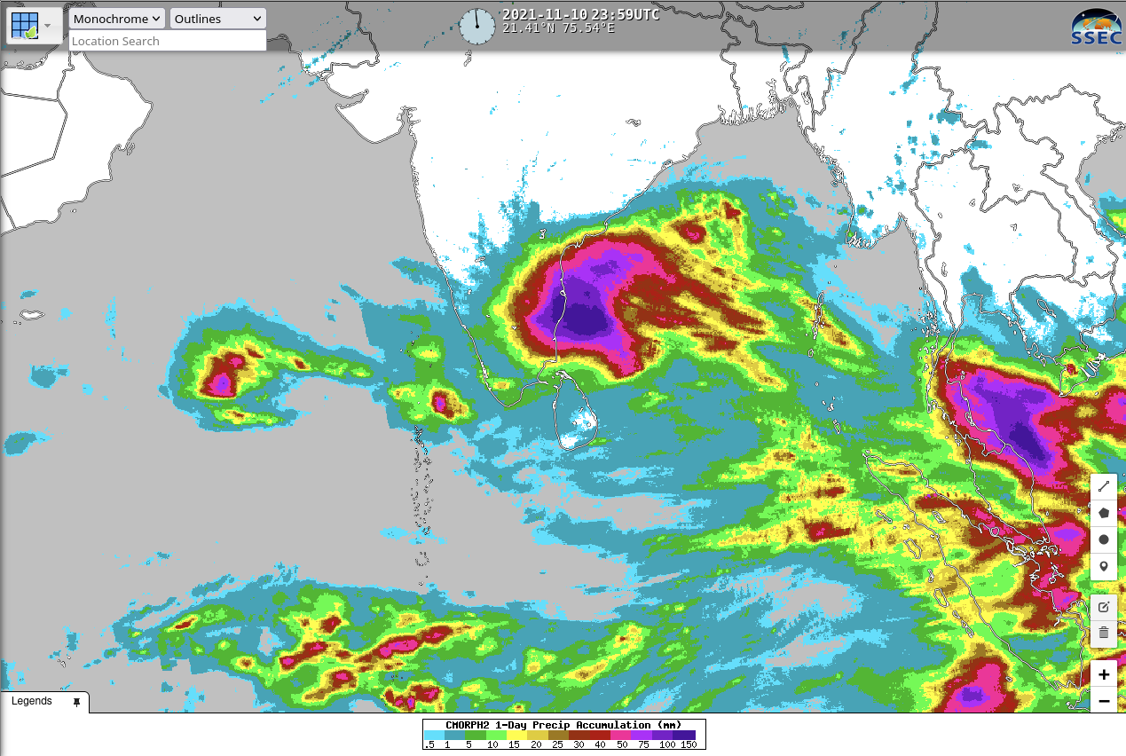
Figure: Accumulated precipitation on Nov. 10, 2021 over the Bay of Bengal resulting from a tropical cyclone that developed in the region. The highest value in the color bar is 150 mm; however, the heaviest accumulations exceeded 300mm. Read more at the CIMSS Satellite Blog: https://cimss.ssec.wisc.edu/satellite-blog/archives/43199. Credit: CMORPH (Climate Prediction Center MORPHing technique), SSEC RealEarth.
 (Click image to enlarge)
Figure: Numerous hole punch, or fall streak, clouds formed over the Upper Midwest, including parts of Wisconsin, Illinois, Iowa and Minnesota on Nov. 7, 2021. A relatively rare phenomenon, they may form due to unusual properties of cloud droplets. More, including satellite views, at the CIMSS Satellite Blog: https://cimss.ssec.wisc.edu/satellite-blog/archives/43166. Credit: T. Wagner, CIMSS.
OTHER:
| Archived Weeklies Page | Submit a report item |