[ Archive ]
| CIMSS-NOAA Weekly Report [ Archive ] |
CIMSS AND ASPB WEEKLY HIGHLIGHTS FOR THE WEEK ENDING DECEMBER 17, 2021
PRODUCTS AND APPLICATIONS:
AWARDS AND RECOGNITION:
PUBLICATIONS:
WORKSHOPS, CONFERENCES, AND MEETINGS:
CIMSS Presentation at Australian VLAB Center of Excellence: Scott Lindstrom from the Cooperative Institute for Meteorological Satellite Studies (CIMSS) joined in a presentation of interesting satellite imagery, coordinated by Bodo Zeschke of the Bureau of Meteorology (Australia) as part of the monthly Australian VLab Centre of Excellence Regional Focus Group meeting, held on 16 December 2021. Other contributions were from U Kyaw Lwin Oo (Myanmar), Joe Courtney (Australian Bureau of Meteorology), Jordan Gerth (NWS Office of Observations), Chris Webster (Met Service of New Zealand) and Ok Hee Kim from the Korean Meteorological Administration (KMA). A recorded version of this presentation is available. Scott presented imagery of volcanic eruptions (La Soufriere, Karymsky), California Fires in the Day Night Band, and Denali under clear skies. (Scott Lindstrom, CIMSS, 608-263-4425)
TRAINING AND EDUCATION:
MEDIA AND OUTREACH:
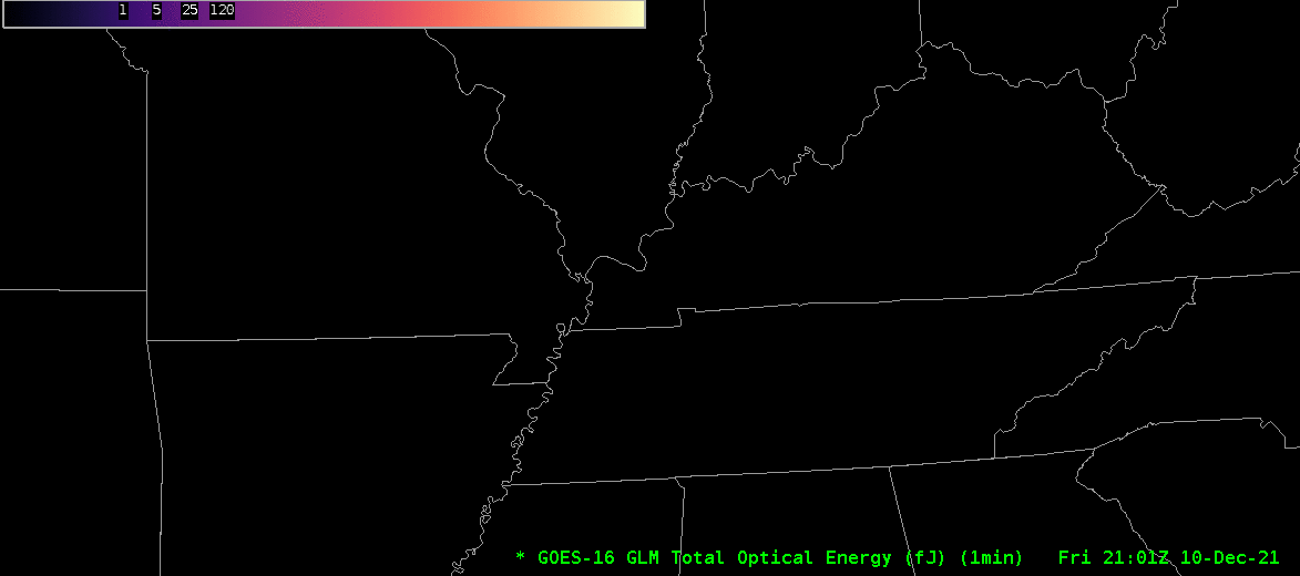
SSEC and CIMSS Scientists in the News: Scientists at the University of Wisconsin-Madison (UW) Space Science and Engineering Center (SSEC) and the Cooperative Institute for Meteorological Satellite Studies (CIMSS) provide expert interviews, imagery and case studies to promote science. This week CIMSS Satellite Blog contributors Scott Bachmeier and Scott Lindstrom published these case studies: "Blowing dust aided by a sting jet across the central Plains" (Dec. 15), "NUCAPS sounding associated with strong winds over the central United States" (Dec. 15), "Ozone and the airmass RGB" (Dec. 13), "Historic tornado outbreak affecting the Midwest and Southeast US" (Dec. 11), and "GLM observations of a long-track tornado" (Dec. 11). Read more at the CIMSS Satellite Blog: https://cimss.ssec.wisc.edu/satellite-blog/. (J. Phillips, SSEC, 608-262-8164, S. Bachmeier, CIMSS, S. Lindstrom, CIMSS)
 (Click image to enlarge)
Figure: One-minute, GOES-16 imagery, with time-matched plots of SPC Storm Reports, provide a close-up view of the long-lived “Quad-State Supercell” thunderstorm that likely produced a family of tornadoes that struck northeast Arkansas, southeast Missouri, northwest Tennessee and western Kentucky late on Dec. 10, 2021. More at the CIMSS Satellite Blog: https://cimss.ssec.wisc.edu/satellite-blog/archives/43754. Credit: CIMSS, NOAA NWS Storm Prediction Center.
 (Click image to enlarge)
Figure: Gridded Geostationary Lightning Mapper (GLM) observations of Total Optical Energy from the tornado-producing storm that hit Mayfield, Kentucky and other locations on Dec. 10, 2021. More at the CIMSS Satellite Blog: https://cimss.ssec.wisc.edu/satellite-blog/archives/43773. Credit: CIMSS, NOAA.
OTHER:
| Archived Weeklies Page | Submit a report item |