[ Archive ]
| CIMSS-NOAA Weekly Report [ Archive ] |
CIMSS AND ASPB WEEKLY HIGHLIGHTS FOR THE WEEK ENDING FEBRUARY 4, 2022
PRODUCTS AND APPLICATIONS:
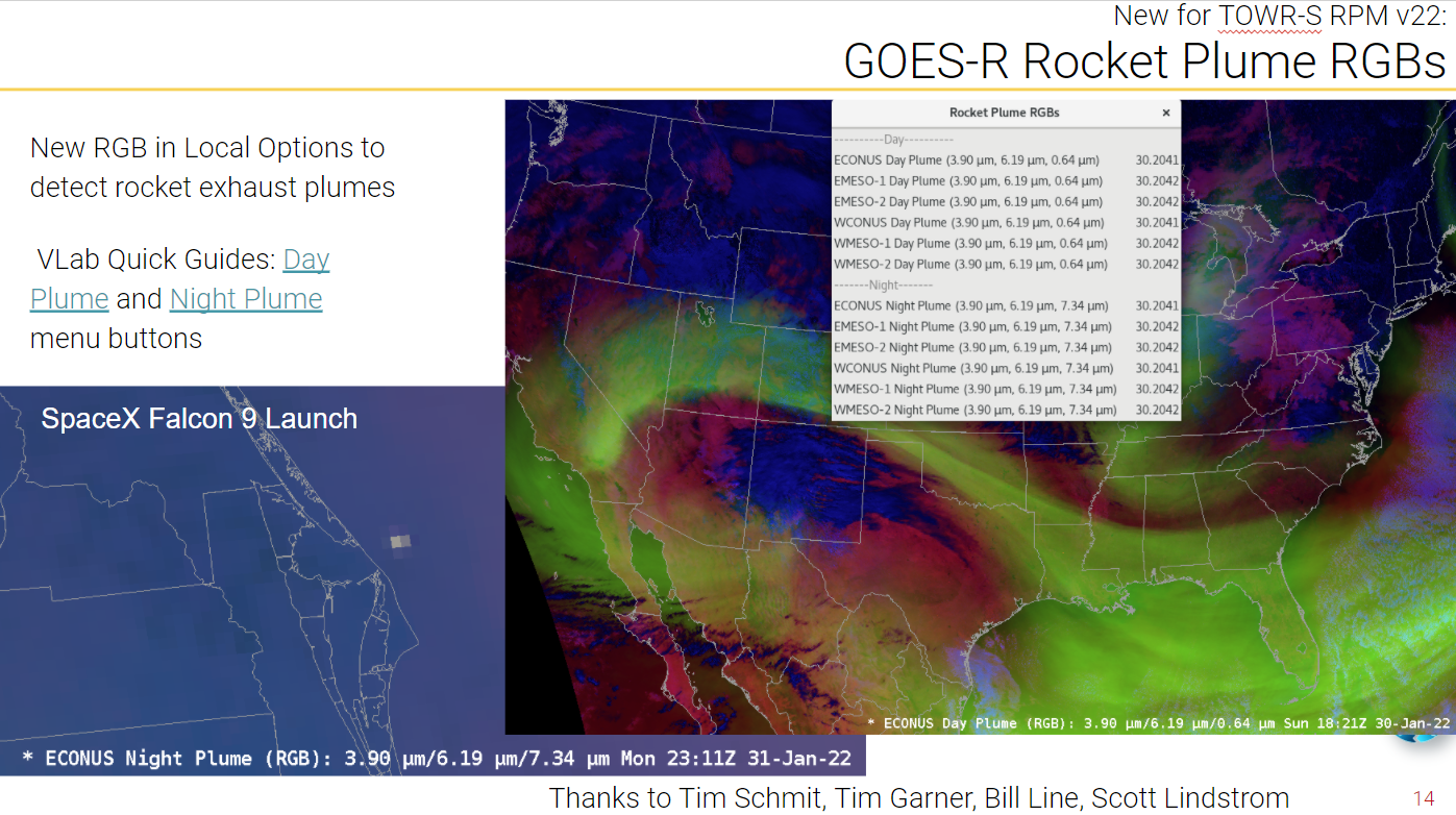
New "Rocket Plume" RGB to the NWS: Two new RGB (Red-Green-Blue) composite image recipes for better highlighting rocket plumes were made available to the NWS via a recent AWIPS (Advanced Weather Interactive Processing System) RPM (version 22) by the TOWR-S (Total Operational Weather Readiness - Satellites) team. There are both day and night quick guide versions (http://cimss.ssec.wisc.edu/goes/OCLOFactSheetPDFs/QuickGuide_Template_GOESRBanner_Plume_day.pdf and http://cimss.ssec.wisc.edu/goes/OCLOFactSheetPDFs/QuickGuide_Template_GOESRBanner_Plume_night.pdf). These RGBs, which use both the 3.9 and 6.2 um bands, are mostly a niche use, for a quick-look/situational awareness or public outreach. (T. Schmit, E/RA2, 608-263-0291; Bill Line, RAMMB)
 (Click image to enlarge)
Figure: Slide from a Satellite Book Club presentation by the TOWR-S team on February 3, 2022 introducing the new RGBs via a local menu option.
AWARDS AND RECOGNITION:
PUBLICATIONS:
WORKSHOPS, CONFERENCES, AND MEETINGS:
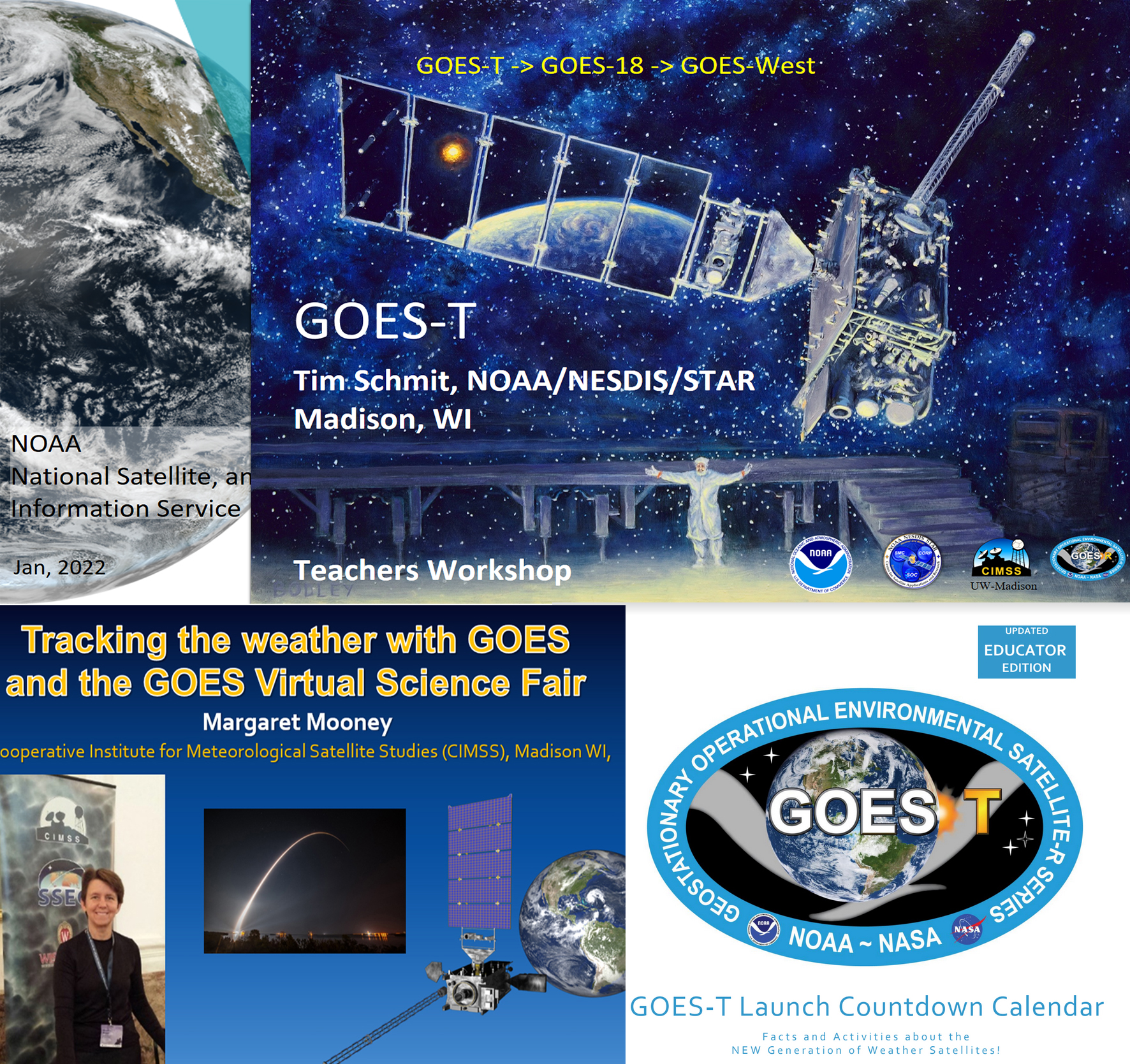
Engaging Teachers and Students around the GOES-T Satellite Launch: Two virtual events were conducted this past week to leverage and elevate engagement around the upcoming GOES T launch. On January 31st, NOAA's Tim Schmit teamed up with New Jersey educator Vicky Gorman and Margaret Mooney from NOAA's Cooperative Institute for Meteorological Satellite Studies (CIMSS) for a "Countdown to Launch" webinar for teachers who had registered for an in-person workshop at Kennedy Space Center that was cancelled due to the pandemic. One teacher from Texas projected the event to her entire classroom! (http://cimss.ssec.wisc.edu/education/goesr/GOES-T.html) Then on February 2nd, Mooney conducted a condensed version of Monday's presentations in the Earth Science Information Partners (ESIP) "Out to Lunch" webinar series. Both events promoted the GOES Virtual Science Fair (http://cimss.ssec.wisc.edu/education/goesr/vsf.html). (M. Mooney,CIMSS, margaret.mooney@ssec.wisc.edu, T. Schmit, E/RA2, 608-263-0291)
 (Click image to enlarge)
Figure: Introductory webinar slides.
TRAINING AND EDUCATION:
VISIT Training on LightningCast Probability: Scott Lindstrom from the Cooperative Institute for Meteorological Satellite Studies (CIMSS) gave a live Virtual Institute for Satellite Integration Training (VISIT) training on LightningCast Probability (part of the ProbSevere portfolio), a product developed at CIMSS by John Cintineo, Mike Pavolonis and Justin Sieglaff to a forecaster in the Melbourne, FL forecast office. Real-time LightningCast Probabilities (and links to training) are available here: https://cimss.ssec.wisc.edu/severe_conv/pltg.html. (S. Lindstrom, CIMSS, 608 263 4425)
MEDIA AND OUTREACH:
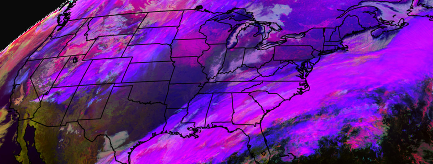
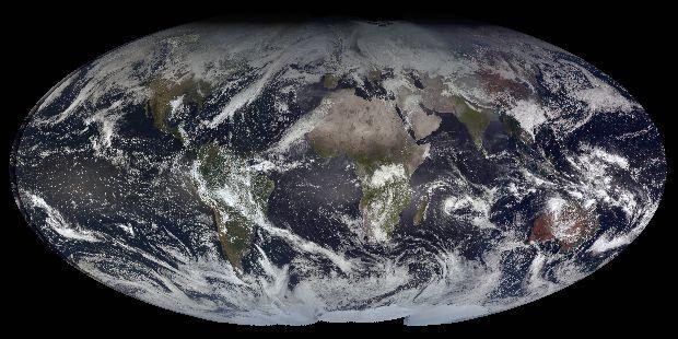
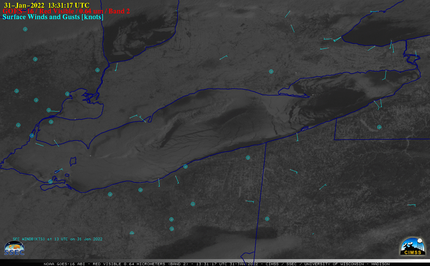
SSEC and CIMSS Scientists in the News: Scientists at the University of Wisconsin-Madison (UW) Space Science and Engineering Center (SSEC) and the Cooperative Institute for Meteorological Satellite Studies (CIMSS) provide expert interviews, imagery and case studies to promote science. This week: 1) NOAA ASPB Scientist Michael Pavolonis and CIMSS Scientist Corey Calvert collaborated on the Fog/Low Stratus product that is now operational with National Weather Service offices. The product assists with warnings issued when conditions favor the formation of fog and low-level clouds; conditions that may make air travel hazardous. SSEC News published this story: https://www.ssec.wisc.edu/news/articles/14247/. 2. Rick Kohrs, a researcher at SSEC, talked with Madison's CapTimes about his technique for creating a stunning global composite using images from five different satellites. One of his composites is exhibited as part of the Data Science Research Bazaar at UW-Madison that features visual art from different science fields. Read more: https://go.wisc.edu/6q5ft8. 3. CIMSS Satellite Blog contributors Scott Bachmeier and Scott Lindstrom published these case studies: "Cyclone Batsirai reaches Category 4 intensity" (Feb. 3), "Ice over the Great Lakes" (Feb. 2), "Cyclone Batsirai in the southern Indian Ocean" (Feb. 1), "North Carolina fertilizer plant fire" (Jan. 31), "Rapid ice growth in Lake Erie" (Jan. 31), "Mid-Atlantic and Northeast US winter storm" (Jan. 29), and "Lake Effect snow over Chicago" (Jan. 28). Read more at the CIMSS Satellite Blog: https://cimss.ssec.wisc.edu/satellite-blog/. (J. Phillips, SSEC, 608-262-8164, E. Verbeten, SSEC, M. Pavolonis, E/RA2, 608-263-9597, C. Calvert, CIMSS, R. Kohrs, SSEC, S. Bachmeier, CIMSS, S. Lindstrom, CIMSS)
 (Click image to enlarge)
Figure: In 2021, the GOES-R Fog and Low Stratus satellite product became operational in National Weather Service offices across the country to help airlines and passengers avoid costly delays and warn smaller aircraft of potential danger. Read more: https://www.ssec.wisc.edu/news/articles/14247/. Credit: Corey Calvert, CIMSS.
 (Click image to enlarge)
Figure: Developed at SSEC, "High Noon From Geostationary Orbit" is a composite image using images from five different satellites. Read more: https://go.wisc.edu/6q5ft8. Credit: Rick Kohrs, SSEC.
 (Click image to enlarge)
Figure: GOES-16 images captured ice growth across Lake Erie on Jan. 31, 2022. Light surface winds minimized stress on the pack ice. Read more at the CIMSS Satellite Blog: https://cimss.ssec.wisc.edu/satellite-blog/archives/44505. Credit: CIMSS, NOAA.
OTHER:
| Archived Weeklies Page | Submit a report item |