[ Archive ]
| CIMSS-NOAA Weekly Report [ Archive ] |
CIMSS AND ASPB WEEKLY HIGHLIGHTS FOR THE WEEK ENDING FEBRUARY 11, 2022
PRODUCTS AND APPLICATIONS:
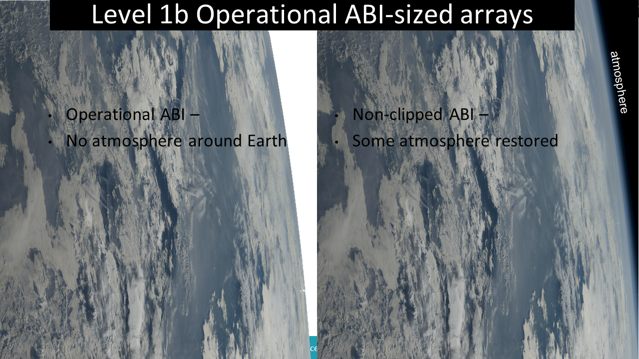
Sample "non-clipped" ABI data: Tim Schmit gave presentations to the Calibration and Algorithm working groups regarding “non-clipped” GOES ABI data. It is shown that much of the ring of the atmosphere around the Earth can be reclaimed through special processing, even while maintaining the current ABI radiance array size. (T. Schmit, E/RA2)
 (Click image to enlarge)
Figure: A GOES-17 ABI example from December 25, 2021 of what would be possible (right side) if we filled in more of the ABI radiance array, compared to what is done operational (left side). The images are the CIMSS true color composites.
AWARDS AND RECOGNITION:
PUBLICATIONS:
Great Lakes Snowfall Measurement Manuscript Published: A manuscript titled "Retrieval of Snow Water Equivalent by the Precipitation Imaging Package (PIP) in the Northern Great Lakes" was recently published in the Journal of Atmospheric and Oceanic Technology (Tokay, A., A. von Lerber, C. Pettersen, M.S. Kulie, D.N. Moiseev, and D.B. Wolff, 2022). Snow water equivalent observations measured by the PIP (optical disdrometer), weighing bucket gauges, and manual snow boards were presented to assess the performance of the PIP for snowfall measurement applications. This instrument package was deployed at the Marquette, MI National Weather Service Weather Forecast Office with the primary goal of taking prolonged snowfall measurements. During the 2017/18 winter, the PIP functioned nearly uninterrupted, accumulating 2345.8 mm of geometric snow depth over a total of 499 h. This study analyzed 30 events that were comprised of a variety of snowfall regimes, and the PIP-retrieved and NWS snow board measured SWE differed less than 15% in every event. Two of the longest duration and highest accumulation events (lake-effect and synoptic snow) were examined in detail. The particle mass with a given diameter was much lower during the shallow, colder, lake-effect event compared to the deep, warmer synoptic event. This study demonstrated that the PIP is a robust instrument for operational use, can reliably derive the bulk properties of falling snow, and is a valuable asset for satellite snow quantitative precipitation estimation algorithm development and evaluation. (M. Kulie, E/RA2, 608-263-6583, mark.kulie@noaa.gov)
Paper on Advances in Protecting Air Traffic from Volcanic Ash Published: A paper entitled, “Progress in protecting air traffic from volcanic ash clouds," was published in the Bulletin of Volcanology. The paper, which was co-authored by a multidisciplinary team, including a NOAA/NESDIS/STAR scientist (M. Pavolonis), summarizes advances in satellite remote sensing and ash dispersion models within the context of improved understanding of the impact of volcanic ash on jet engines. The scientific advances highlighted in the paper, which include the NOAA VOLcanic Cloud Analysis Toolkit (VOLCAT), are enabling changes to International Civil Aviation Organization (ICAO) operating procedures in volcanic ash contaminated airspace, so that massive disruptions, like the 2010 Eyjafjallajökull (Iceland) event, are less likely. The paper is available online (https://link.springer.com/article/10.1007/s00445-021-01511-x). M. Pavolonis, E/RA2, 608-263-9597, Mike.Pavolonis@noaa.gov)
Paper on Volcanic Thunderstorm Published: A paper, entitled “Eruption dynamics leading to a volcanic thunderstorm - The January 2020 eruption of Taal volcano, Philippines,” was published in the journal Geology. Co-authored by scientists from the United States Geological Survey (USGS), NOAA/NESDIS/STAR (M. Pavolonis), and Vaisala, the paper describes the exceptional lightning activity within the cloud generated by the 12 January 2020 eruption of Taal volcano in the Philippines. Flash rates in excess of 70 per minute were observed as the cloud expanded. Such lightning flash rates are uncommon in weather systems, making the Taal cloud unique. The analysis in the paper was enabled by combining data from different sources, including satellites, ground-based lightning detection sensors, and weather balloons. The paper is available online (https://pubs.geoscienceworld.org/gsa/geology/article-abstract/doi/10.1130/G49490.1/610898/Eruption-dynamics-leading-to-a-volcanic). M. Pavolonis, E/RA2, 608-263-9597, Mike.Pavolonis@noaa.gov)
WORKSHOPS, CONFERENCES, AND MEETINGS:
TRAINING AND EDUCATION:
VISIT NUCAPS Training updated: The Virtual Institute for Satellite Integration Training (VISIT) module on NOAA-Unique CrIS/ATMS Processing System (NUCAPS) vertical profiles has been updated. The module, introduced in 2014 and updated about biennially since then, tells forecasters how to find NUCAPS profiles in AWIPS and how the data can be used to assess the current state of the thermodynamics of the atmosphere. The latest update includes more information on Gridded NUCAPS fields that were introduced to the field in the recent past. A recorded version of the training has been created: https://www.youtube.com/watch?v=LQcEOKZCe_I. (Scott Lindstrom, CIMSS, 608 263 4425)
VISIT Training on LightningCast Probability: Scott Lindstrom from the Cooperative Institute for Meteorological Satellite Studies (CIMSS) gave a live Virtual Institute for Satellite Integration Training (VISIT) training on LightningCast Probability (part of the ProbSevere portfolio), a product developed at CIMSS by John Cintineo, Mike Pavolonis and Justin Sieglaff, to forecasters at the Atlanta, GA, Sterling VA and Tampa, FL Forecast Offices and the Cleveland CWSU. Real-time LightningCast Probabilities (and links to training) are available here: https://cimss.ssec.wisc.edu/severe_conv/pltg.html. (S. Lindstrom, CIMSS, 608 263 4425)
VISIT Teletraining on ProbSevere v.2: Scott Lindstrom from the Cooperative Institute for Meteorological Satellite Studies (CIMSS) gave a Virtual Institute for Satellite Integration Training (VISIT) presentation on NOAA/CIMSS ProbSevere (version 2) to forecasters at the Brownsville TX and Tampa FL forecast offices. This product is used in operations to boost confidence (and increase lead-time) in warning issuance for severe wind, hail and tornadic events. (S. Lindstrom, CIMSS, 608 263 4425)
MEDIA AND OUTREACH:
NESDIS/STAR Contribution to 2021 NOAA Science Report Showcased in Seminar Series: The STAR-led Probability of Severe (ProbSevere) project was featured in the 2021 NOAA Science Report Seminar Series (https://libguides.library.noaa.gov/seminars/upcoming/NOAA-Science-Report-Seminar-Series-Observations-and-Data-Collection), held on February 9, 2022, in a presentation entitled “Artificial Intelligence Tool Improves Severe Weather Warnings.” ProbSevere, which was developed at the University of Wisconsin Cooperative Institute for Meteorological Satellite Studies (UW-CIMSS), was successfully transitioned to National Weather Service (NWS) operations in fiscal year 2021. Operational forecasters use ProbSevere to identify severe weather threats, such as hail, strong winds, and tornadoes, with greater confidence and lead time, resulting in improved warnings to the public. The seminar was recorded and is available on YouTube (https://www.youtube.com/watch?v=jUmLxVi7wbg). (M. Pavolonis, E/RA2, 608-263-9597, Mike.Pavolonis@noaa.gov, J. Cintineo, CIMSS)
SSEC and CIMSS Scientists in the News: Scientists at the University of Wisconsin-Madison (UW) Space Science and Engineering Center (SSEC) and the Cooperative Institute for Meteorological Satellite Studies (CIMSS) provide expert interviews, imagery and case studies to promote science. This week: CIMSS Satellite Blog contributors Scott Bachmeier and Scott Lindstrom published these case studies: "Natural gas flaring cloud plumes across the North Slope of Alaska" (Feb. 8), "Lake Erie ice floes" (Feb. 6), "Actinoform clouds near Bermuda" (Feb. 5), "Cyclone Batsirai makes landfall in Madagascar" (Feb. 5), "Satellite signatures of widespread ice accretion" (Feb. 4-5), and "Power outages over the mid-South" (Feb. 4). Read more at the CIMSS Satellite Blog: https://cimss.ssec.wisc.edu/satellite-blog/. (J. Phillips, SSEC, 608-262-8164, S. Bachmeier, CIMSS, S. Lindstrom, CIMSS)
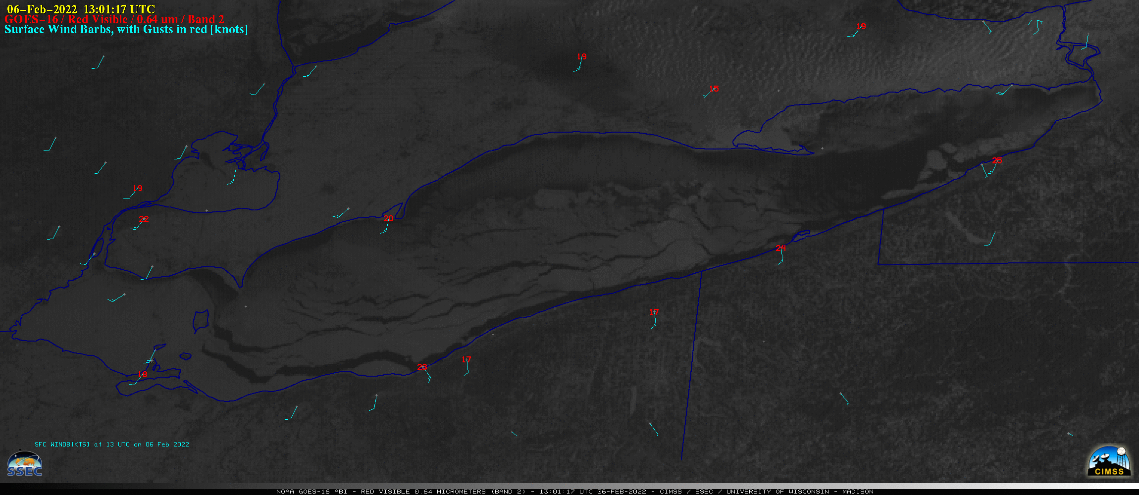 (Click image to enlarge)
Figure: GOES-16 images showed widespread ice on Lake Erie on Feb. 6, 2022. Increasing southerly/southwesterly winds opened numerous ice leads, resulting in the north/northeastward drift of large ice floes across the eastern part of the lake. Read more at the CIMSS Satellite Blog: https://cimss.ssec.wisc.edu/satellite-blog/archives/44574. Credit: CIMSS, NOAA.
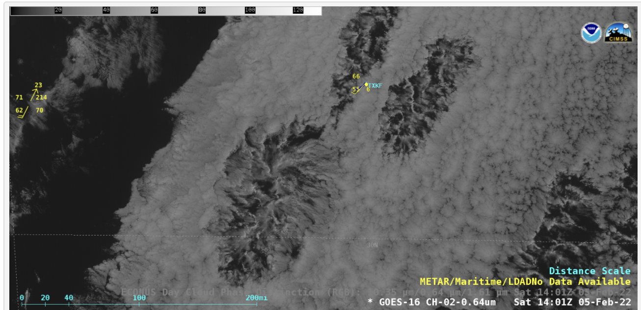 (Click image to enlarge)
Figure: Normally seen over the Pacific Ocean, GOES-16 captured the formation of actinoform clouds near Bermuda on Feb. 5, 2022. Animation at https://bit.ly/3Bf0WaS. Read more at the CIMSS Satellite Blog: https://cimss.ssec.wisc.edu/satellite-blog/archives/44548. Credit: CIMSS, NOAA.
OTHER:
| Archived Weeklies Page | Submit a report item |