[ Archive ]
| CIMSS-NOAA Weekly Report [ Archive ] |
CIMSS AND ASPB WEEKLY HIGHLIGHTS FOR THE WEEK ENDING FEBRUARY 18, 2022
PRODUCTS AND APPLICATIONS:
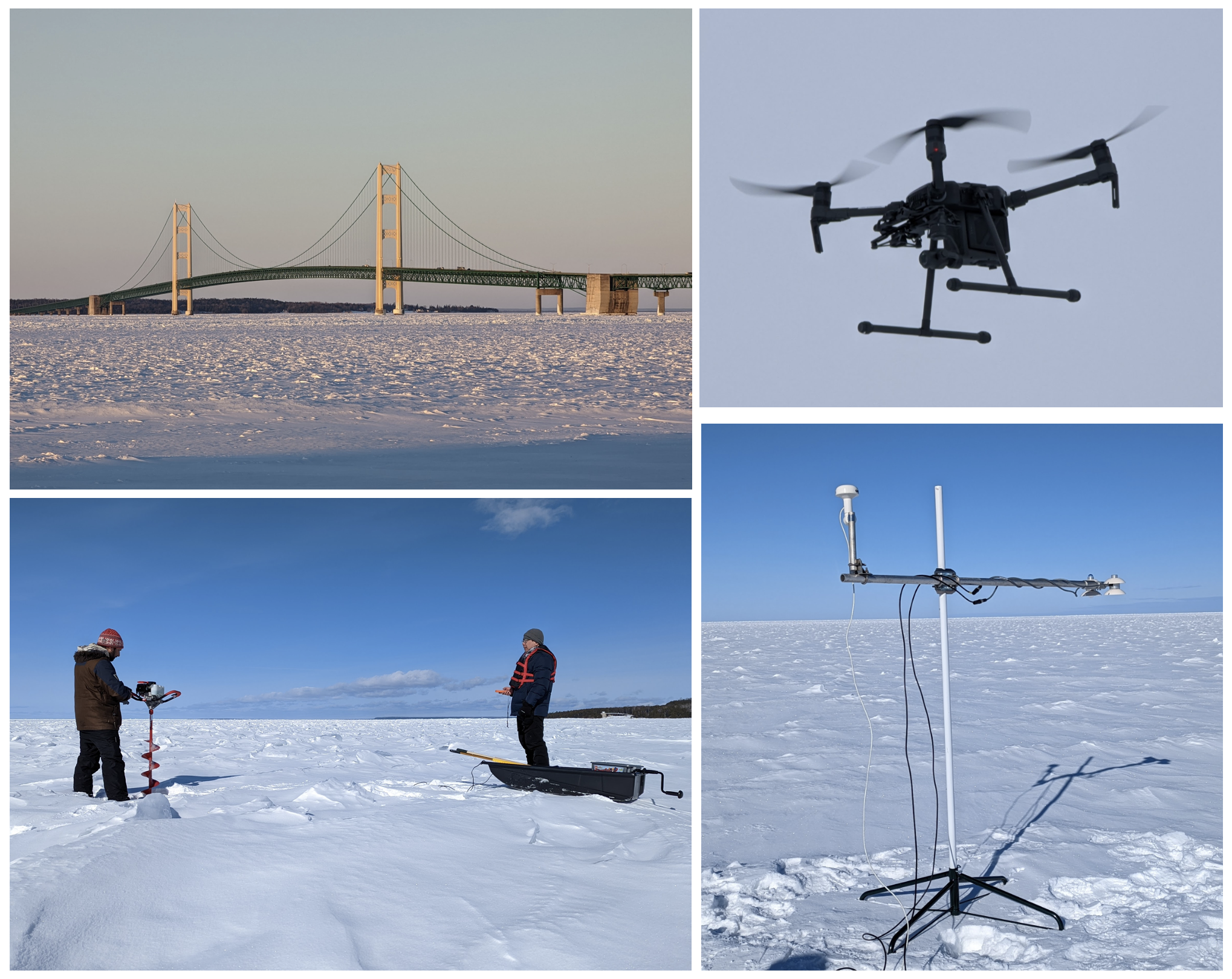
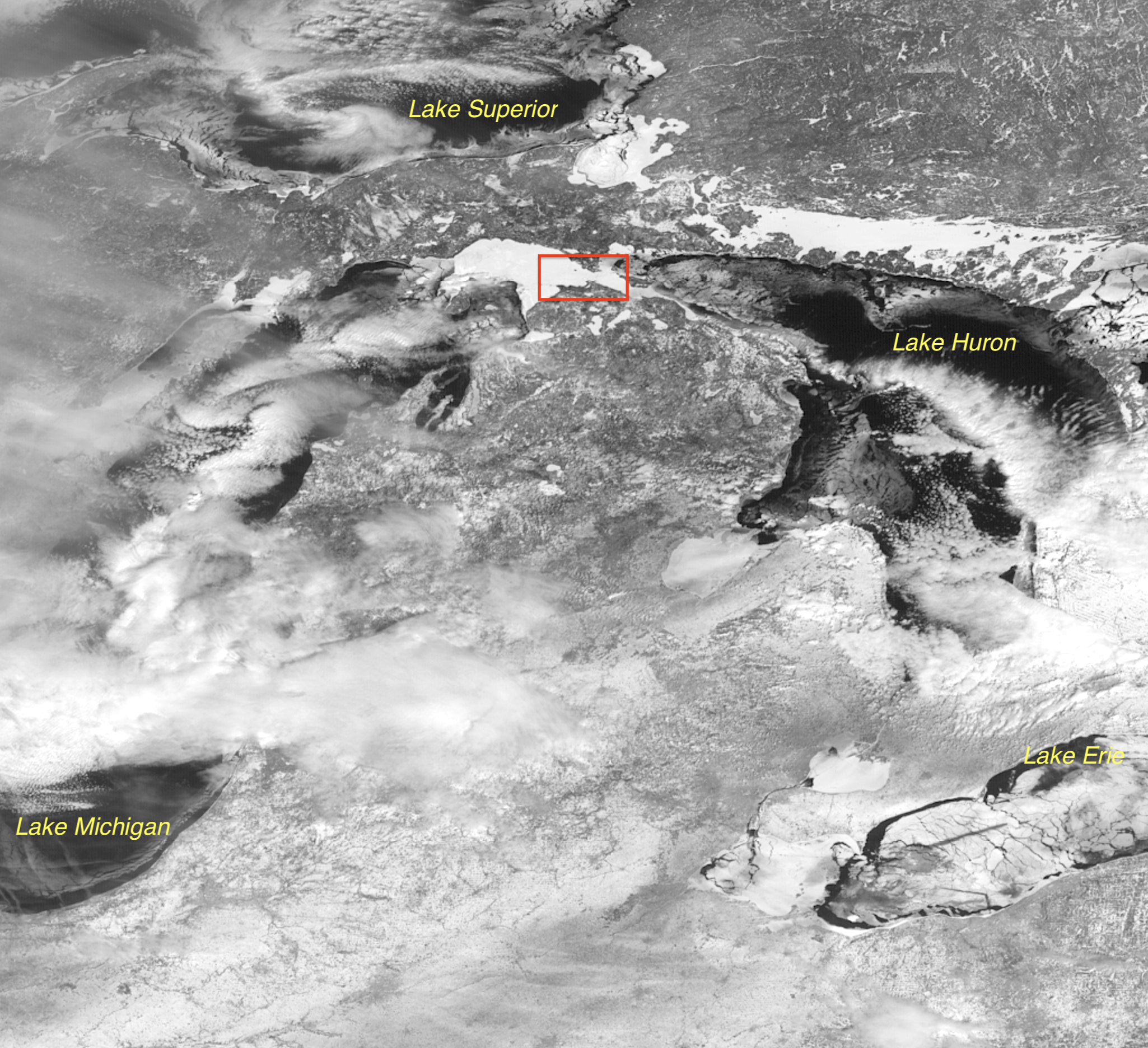
UAS Validation Experiment in the Straits of Mackinac: Scientists from the NOAA/STAR Advanced Satellite Products Branch (ASPB) and the Cooperative Institute for Meteorological Satellite Studies (CIMSS) participated in UAS (Uncrewed Aircraft System) Sea Ice Retrieval for Calibration/Validation Experiment (USIR-CV EX) in the Straits of Mackinac, Michigan, 14-18 February 2022. The experiment used advanced hybrid quadrotor UAS platforms with customized multispectral payloads to gather critical data for validation of NESDIS' operational ice products and experimental ice products from Synthetic Aperture Radar (SAR), CryoSat-2, and ICESat-2. While NESDIS products have been validated globally, there remains little understanding of local performance in the Arctic or Great Lakes. The USIR-CV EX provides a new data source to understand ice algorithm performance for key parameters needed in navigation and ice modeling, such as ice concentration, ice surface temperature, and ice thickness. The experiment will contribute knowledge on UAS operations over the Great Lakes and, next year, the Arctic. Integration, testing, data collection, planning/execution, and piloting of the platform and payload was supported by GeoThinkTank LLC and the University of Maryland (UMD) UAS Test Site. STAR and CIMSS scientists took measurements of ice thickness, snow properties, and surface meteorology with the UAS and satellites flying overhead. NOAA granted a request for mesoscale, 1-minute imagery from GOES-16 for part of the week. Yinghui Liu, Aaron Letterly, Rich Dworak, and Jeff Key from ASPB and CIMSS participated. Sean Helfrich (STAR), the project PI, also participated. (J. Key, E/RA2, 608-263-2605, jeff.key@noaa.gov)
 (Click image to enlarge)
Figure: The Mackinaw Bridge over lake ice, the UAS vehicle, Yinghui Liu and Sean Helfrich (STAR) taking measurements, and a net radiometer (courtesy of Jonathan Thom, SSEC) on the ice.
 (Click image to enlarge)
Figure: GOES-16 ABI band 2 image of the Great Lakes on 15 February 2022 at 16:12 UTC. Measurements were made on the south side (bottom left) of the red box.
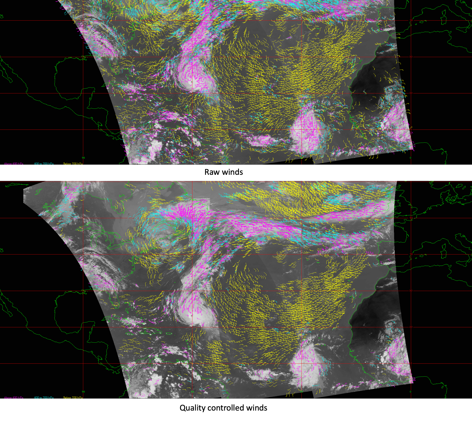
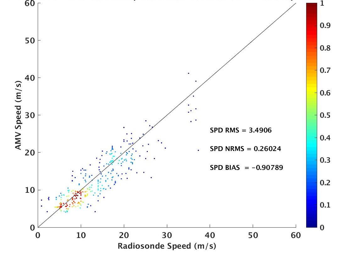
VIIRS Tandem Wind Product: Initial Evaluation: Typically, satellite-derived winds are generated using a triplet of images from a single satellite, which results in a pair of wind vectors for each feature that is tracked in time. The consistency of the vector pair is a key component in determining the quality of the wind. An experimental product is in development by the NOAA/CIMSS (Cooperative Institute for Meteorological Satellite Studies) polar winds team which uses a doublet (pair) of images for deriving wind information. The product is termed ‘tandem winds’ as it uses successive orbits of Visible Infrared Imaging Radiometer Suite (VIIRS) images from two satellites (Suomi-NPP and NOAA-20) that fly in tandem, separated by approximately 50 minutes. A quality control similar to the triplet method is achieved by using a proxy wind vector as the second vector: A time- and space-coincident satellite-derived wind from other polar and geostationary orbiting satellites. The resulting tandem winds product has daily global coverage of satellite winds from polar satellites, as there is significant overlap in alternating passes of S-NPP and NOAA-20. The first figure below shows the raw winds (upper) and quality control winds (lower) for six time periods on 30 September 2021 over the North Atlantic Ocean. The second figure is a scatter plot (color coded by density) of a comparison of the tandem winds to rawinsondes. This initial comparison is for seven days in September 2021, yielding a vector root-mean-square error (RMSE) of 5.11 m/s and vector accuracy of 4.45 m/s, which are similar to that of triplet derived winds. (D. Santek, CIMSS, 608-263-7410, R. Dworak, CIMSS, 608-265-8620, T. Olander, CIMSS, 608-265-8005, D. Stettner, CIMSS, 608-262-8850, J. Key, E/RA2, 608-263-2605, jeff.key@noaa.gov)
 (Click image to enlarge)
Figure: Tandem winds derived over the North Atlantic on 30 September 2021. The upper panel depicts the raw winds; lower panel is quality controlled. The wind flags are color coded: magenta (high level), cyan (mid level), and yellow (low level).
 (Click image to enlarge)
Figure: Scatter plot comparing global tandem winds for seven days in late September 2021 to rawinsondes. The sample size is 1500 matches.
Advanced Dvorak Technique passes CDR for MTG data: The Advanced Dvorak Technique (ADT) has completed the Critical Design Review (CDR) for the upcoming operational implementation of the Meteosat Third Generation (MTG) geostationary satellite data. MTG is currently scheduled to be launched in Fall of 2022 and become operational in 2023, replacing the current Meteosat Second Generation (MSG) satellites. The ADT, which provides tropical cyclone intensity estimates using current infrared window channel imagery from all current geostationary satellites, including GOES-16/17, MSG, and Himawari-8, will become operational at NOAA in late February or early March, 2022. The ADT CDR outlined the current plans to ingest and test proxy MTG data provided by the European Organization for the Exploitation of Meteorological Satellites (EUMETSAT) within the ADT algorithm. The process described within the ADT CDR will provide an outline for the implementation and use of the operational EUMETSAT MTG data within NOAA operations explicitly for the production of the ADT intensity estimates. (T. Olander, CIMSS, 608-265-8005, C. Velden, CIMSS, 608-262-9168, J. Key, E/RA2, 608-263-2605, jeff.key@noaa.gov)
AWARDS AND RECOGNITION:
PUBLICATIONS:
WORKSHOPS, CONFERENCES, AND MEETINGS:
TRAINING AND EDUCATION:
CIMSS Participation in JPSS/GOES Short Course: Cooperative Institute for Meteorological Satellite Studies (CIMSS) Scientists William Straka and Scott Lindstrom led discussions on Satellite-derived moisture and flood products during a 2-day JPSS/GOES-R Short Course presented by the American Meteorological Society's Satellite Meteorology, Oceanography and Climatology (SATMOC) committee. The Day 1 activities included identification and description of satellite-derived moisture and precipitation products, how they are useful and where they are found online. In addition, Straka and Lindstrom oversaw a hands-on activity that had the 19 students identify a flooding event, describe its antecedent conditions, quantify the rainfall, and outline where the flooding occurred. A Day-2 wrap-up included a discussion of how fires (the subject of Day 2) can lead to flash flooding. The training event was recorded by AMS and will be made available at the class website: https://rammb.cira.colostate.edu/training/visit/links_and_tutorials/2022_AMS_Satellite_Short_Course.asp. (W. Straka, S. Lindstrom, CIMSS; 608 263 4425)
MEDIA AND OUTREACH:
SSEC and CIMSS Scientists in the News: Scientists at the University of Wisconsin-Madison (UW) Space Science and Engineering Center (SSEC) and the Cooperative Institute for Meteorological Satellite Studies (CIMSS) provide expert interviews, imagery and case studies to promote science. This week: CIMSS Satellite Blog contributors Scott Bachmeier and Scott Lindstrom published these case studies: "Blowing dust across Death Valley in Southern California" (Feb. 15), "Tracking a ship through the ice of Lake Erie" (Feb. 14), "GOES-16 Cryosphere Level 2 Products" (Feb. 14), "Mesovortices over the Great Lakes" (Feb. 13), "Blowing snow across North Dakota and Minnesota" (Feb. 11), and "Adding gridded NUCAPS field to new AWIPS RGB loads" (Feb. 11). Read more at the CIMSS Satellite Blog: https://cimss.ssec.wisc.edu/satellite-blog/. (J. Phillips, SSEC, 608-262-8164, S. Bachmeier, CIMSS, S. Lindstrom, CIMSS)
 (Click image to enlarge)
Figure: GOES-16 images on Feb. 15, 2022 show a ship's track through the ice on Lake Erie. Read more at the CIMSS Satellite Blog: https://cimss.ssec.wisc.edu/satellite-blog/archives/44646. Credit: CIMSS, NOAA.
OTHER:
| Archived Weeklies Page | Submit a report item |