[ Archive ]
| CIMSS-NOAA Weekly Report [ Archive ] |
CIMSS AND ASPB WEEKLY HIGHLIGHTS FOR THE WEEK ENDING MARCH 4, 2022
PRODUCTS AND APPLICATIONS:
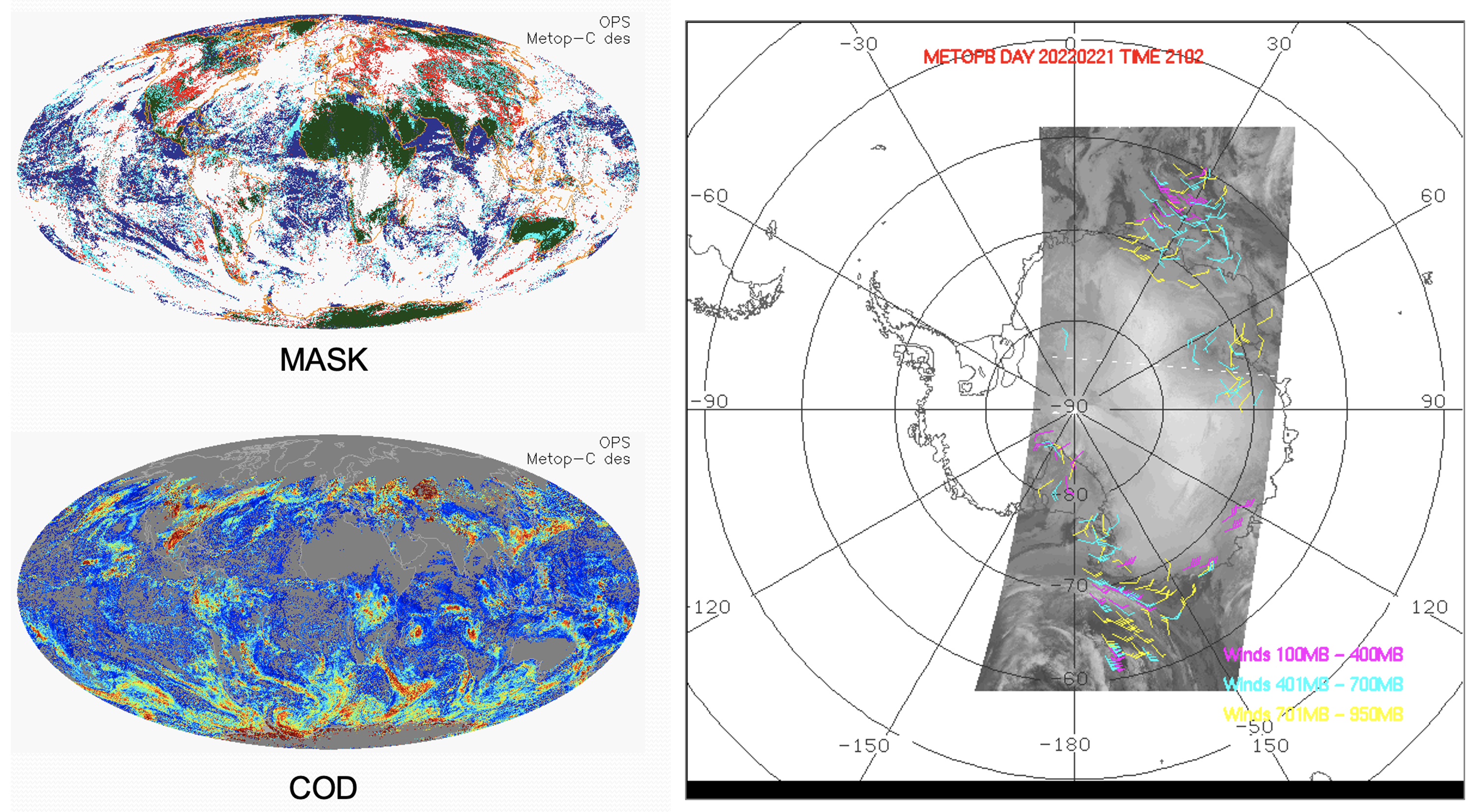
Operational Readiness Review for Metop-B/C Clouds and Winds: A NEDSIS Operational Readiness Review (ORR) for Metop-B/C clouds and polar winds was held on March 2, 2022. It primarily concerned the migration of the legacy products to processing in the "cloud". Mark Kulie (STAR/ASPB) presented the validation of (atmospheric) cloud products with support from Steve Wanzong, Denis Botambekov, Yue Li, Andi Walther, William Straka, Mike Foster (Cooperative Institute for Meteorological Satellite Studies, CIMSS), and Andy Heidinger (GeoXO). Rico Allegrino (STAR affiliate) presented the polar winds validation, with input from Dave Santek (CIMSS/SSEC), Jaime Daniels (STAR), and Jeff Key (STAR/ASPB). Members of NESDIS Algorithm Scientific Software Integration and System Transition Team (ASSISTT) and the Office of Satellite and Product Operations (OSPO) presented risks, requirements, system integration, testing, and operational readiness. (J. Key, E/RA2, 608-263-2605, jeff.key@noaa.gov; M. Kulie, E/RA2, 608-263-6583, mark.kulie@noaa.gov)
 (Click image to enlarge)
Figure: Examples of (left) Metop-C cloud mask and cloud optical depth (COD), and (right) Metop-B polar winds over the Antarctic.
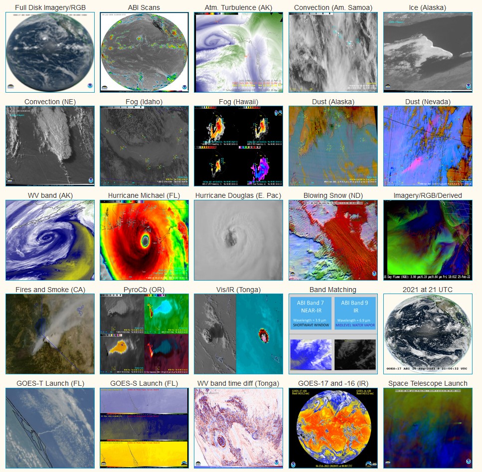
"Top 25" GOES-West Loops Posted: To celebrate the launch of GOES-T, a collection of 25 select loops highlighting the diverse capabilities of the Advanced Baseline Imager (ABI) were generated and/or collected (primarily from the CIMSS Satellite Blog). The collection showcases different spectral bands, spatial coverages and temporal scales. See the collection at https://cimss.ssec.wisc.edu/goes/abi/youtube/ABI_loops25_G17.html. Examples include imagery of hurricanes, convection, dust, volcanic eruptions, fire/smoke, fog, ice movement, blowing snow and derived products. It also includes the GOES-T launch as seen from GOES-17: https://cimss.ssec.wisc.edu/goes/abi/youtube/YouTube_GOEST_launch_G17_color.html. (T. Schmit, E/RA2, 608-263-0291)
 (Click image to enlarge)
Figure: Thumbnails of the 25 select GOES-17 ABI animations, which are available in YouTube, animated gif and mp4 formats.
AWARDS AND RECOGNITION:
WORKSHOPS, CONFERENCES, AND MEETINGS:
Invited Presentation to WMO: Jim Kossin (SSEC/CIMSS) presented a talk "Tropical Cyclones and Climate Change" at the WMO RA-IV Workshop on Hurricane Forecasting and Warning. (J. Kossin, jpkossin@wisc.edu)
TRAINING AND EDUCATION:
GOES-R/JPSS Quick Guides created and updated: Scott Lindstrom from the Cooperative Institute for Meteorological Satellite Studies (CIMSS) has created 3 new Quick Guides for baseline Level 2 products that are available to forecaster: Land Surface Temperature, Ice Concentration and Ice Surface Temperature. These are available on-line (http://cimss.ssec.wisc.edu/goes/OCLOFactSheetPDFs/QuickGuide_GOESR_LandSurfaceTemperature.pdf, http://cimss.ssec.wisc.edu/goes/OCLOFactSheetPDFs/QuickGuide_GOESR_IceConcentration.pdf and http://cimss.ssec.wisc.edu/goes/OCLOFactSheetPDFs/QuickGuide_GOESR_IceSurfaceTemperature.pdf, respectively); they are also within the NOAA VLab STOR and available via the AWIPS Interactive Resource (AIR). The JPSS Ice Concentration Quick Guide (http://cimss.ssec.wisc.edu/goes/OCLOFactSheetPDFs/JPSSQuickGuide_Ice_Concentration_2022.pdf) was modified to align with the information within the GOES-R Quick Guide. (Scott Lindstrom and Aaron Letterly, CIMSS, 608 263 4425)
MEDIA INTERACTIONS AND REQUESTS:
SOCIAL MEDIA AND BLOG POSTS:
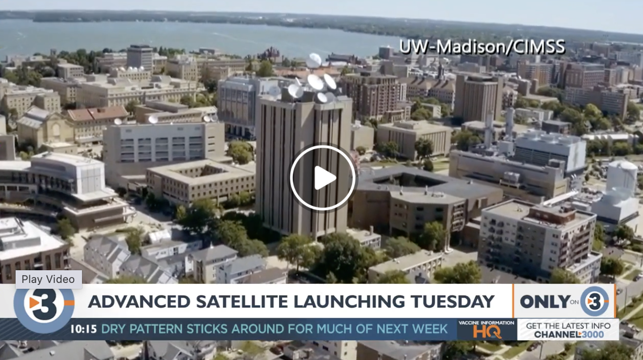
SSEC and CIMSS Scientists in the News: Scientists at the University of Wisconsin-Madison (UW) Space Science and Engineering Center (SSEC) and the Cooperative Institute for Meteorological Satellite Studies (CIMSS) provide expert interviews, imagery and case studies to promote science. This week: 1. CIMSS Director and Professor Tristan L'Ecuyer talked with Madison's WISC-TV about the UW's involvement in GOES-T and its well-earned name as the "birthplace of satellite meteorology." Read more: https://go.wisc.edu/110ly4. 2. ASPB Scientist Michael Pavolonis and CIMSS Scientist John Cintineo were interviewed by Iowa's News Now about NOAA/CIMSS products that aid forecasters in better predicting the likelihood of thunderstorms and fog. Read more: https://go.wisc.edu/n64469. 3. ASPB Scientist Tim Schmit did remote interviews on GOES-T with WSVN (Miami, FL), WHO 13 (Des Moines, IA) and KFOR Radio (Lincoln, NE) and provided imagery for their stories on the Hunga Tonga volcanic eruption in Jan. 2022. 4. Colleagues and classmates, former National Weather Service Director Louis Uccellini and WGN News Meteorologist Tom Skilling visited SSEC and the Department of Atmospheric and Oceanic Sciences for a story that highlighted advances in weather forecasting since their college days at UW-Madison. Read more: https://go.wisc.edu/0u084x. 5. CIMSS Satellite Blog contributors Scott Bachmeier, Scott Lindstrom and Alexa Ross published these case studies: "Detection of fog during a fatal crash in Florida" (Mar. 3), "Turbulence Probability and Aviation" (Mar. 2), "GOES-T launch, as viewed by GOES-16 and GOES-17" (Mar. 1), "Turbulence associated with transverse cloud banding" (Feb. 28), "Snow Squall in the Northeast U.S." (Feb. 28), "Fujiwhara interaction between Cyclone Vernon and Invest 93S over the South Indian Ocean" (Feb. 27), "Satellite detection of ice" (Feb. 26), and "Using NUCAPS and GOES-16 Level 2 Stability products and LightningCast to anticipate lightning" (Feb. 25). Read more at the CIMSS Satellite Blog: https://cimss.ssec.wisc.edu/satellite-blog/. (J. Phillips, SSEC, 608-262-8164, T. L'Ecuyer, CIMSS, M. Pavolonis, E/RA2, J. Cintineo, CIMSS, T. Schmit, E/RA2, S. Bachmeier, CIMSS, S. Lindstrom, CIMSS, A. Ross, SSEC)
 (Click image to enlarge)
Figure: CIMSS Director Tristan L'Ecuyer's interview on UW-Madison's involvement in GOES-T and its foundational role in satellite meteorology. Listen here: https://go.wisc.edu/110ly4. Credit: WISC-TV Madison, WI.
 (Click image to enlarge)
Figure: Pinpoint lightning predictions: new satellite revolutionizing weather forecasting: An interview with NOAA's M. Pavolonis and CIMSS' J. Cintineo. Listen here: https://go.wisc.edu/n64469. Credit: Iowa's News Now.
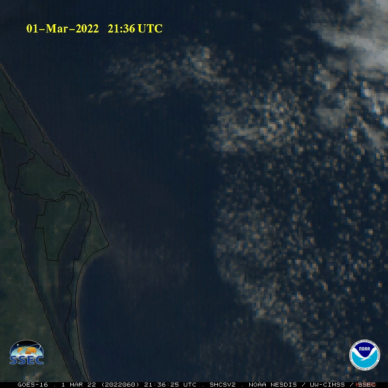 (Click image to enlarge)
Figure: GOES-16 imagery of the GOES-T launch on Mar. 1, 2022 highlighting the rocket condensation plume. Read more at the CIMSS Satellite Blog: https://cimss.ssec.wisc.edu/satellite-blog/archives/44902. Credit: T. Schmit, NOAA/NESDIS/ASPB, CIMSS.
PUBLICATIONS:
Accepted Paper Validating Simulated Water Vapor Brightness Temperatures: A paper analyzing the impacts of different numerical weather prediction model (NWP) parameters such as microphysics scheme, planetary boundary layer scheme, and land surfaces on simulated water vapor (WV) brightness temperatures (BTs) was accepted for publication in the journal Atmospheres. This analysis utilized all three WV BT bands on Geostationary Operational Environmental Satellite (GOES)-16, at 6.2, 6.9, and 7.3 microns, to analyze simulated WV throughout the atmosphere. It was found that different NWP schemes resulted in more or less WV compared to the GOES-16 observations. This analysis also used the gradients in WV BTs to identify the location of upper-level features such as jet streams and troughs. Many of these upper-level features were west of the observed feature for early forecast hours but east of the observations for later forecast hours, indicating enhanced propagation speeds compared to the observations. (S. Griffin, Cooperative Institute for Meteorological Satellite Studies (CIMSS), 608-262-0986, J. Otkin, CIMSS, 608-265-2476)
Manuscript Submitted: Jim Kossin (SSEC/CIMSS) submitted a manuscript to Hydrology and Earth System Sciences (HESS) entitled "Quantifying Hazard Probability and Risk from Ensemble Projections of Downscaled Climate Variables" by Kossin, J. P., Hall, T. M., and Thompson, T. R. (J. Kossin, jpkossin@wisc.edu)
OTHER:
| Archived Weeklies Page | Submit a report item |