[ Archive ]
| CIMSS-NOAA Weekly Report [ Archive ] |
CIMSS AND ASPB WEEKLY HIGHLIGHTS FOR THE WEEK ENDING MARCH 11, 2022
DATA, INFORMATION, AND USE-INSPIRED SCIENCE:
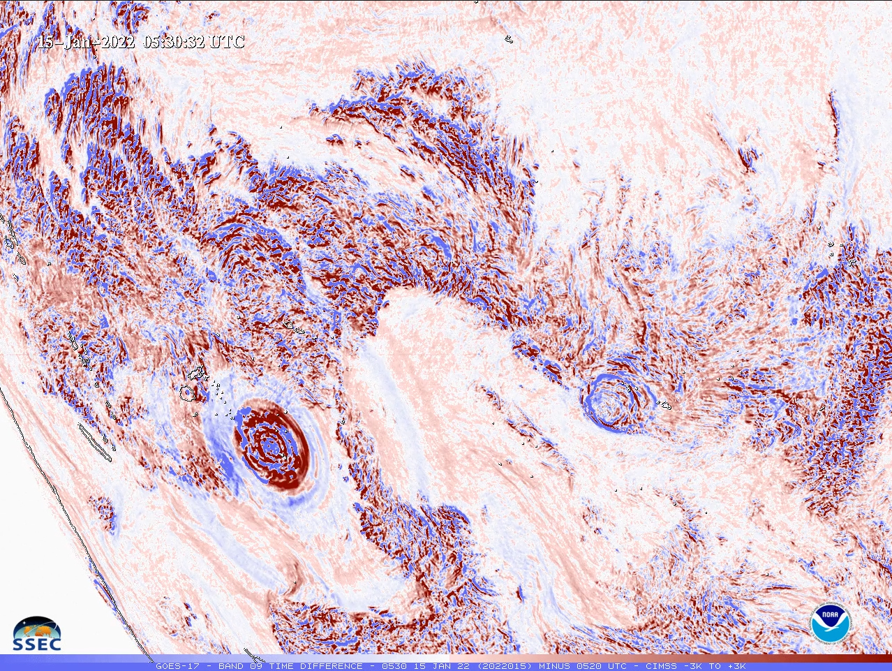
New Tonga Shockwave Dataset for NOAA Science On a Sphere: NOAA's Tim Schmit teamed up with Rick Kohrs from the Space Science and Engineering Center (SSEC) to create a new dataset for NOAA Science On a Sphere (SOS). The animation (https://www.ssec.wisc.edu/~rickk/repro-tonga.html) demonstrates how the pressure wave from the explosive Tonga volcanic eruption rippled around the globe as seen in geostationary water vapor imagery. NOAA has 177 SOS exhibits worldwide which consist of 6-foot diameter spheres ideal for sharing satellite imagery with the science-interested public. Along with the global dataset, a zoomed-in view of the pressure wave is on YouTube at https://cimss.ssec.wisc.edu/goes/abi/youtube/YouTube_Tonga1.html. (T. Schmit, E/RA2, 608-263-0291, tim.j.schmit@noaa.gov, R. Kohrs, SSEC, rickk@ssec.wisc.edu, M. Gunshor, CIMSS, M. Mooney, CIMSS)
 (Click image to enlarge)
Figure: GOES-17 Water Vapor Time Difference -- Tonga.
AWARDS AND RECOGNITION:
WORKSHOPS, CONFERENCES, AND MEETINGS:
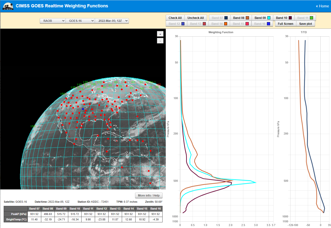
CIMSS Participation in weekly TOWR-S Satellite Book Club Seminar Series: Scott Lindstrom from the Cooperative Institute for Meteorological Satellite Studies (CIMSS) was co-presenter with Christopher Gitro, Meteorologist-in-Charge (MIC) at the NWS Forecast Office in Duluth (WFO DLH) on a Satellite Book Club seminar, a short seminar series sponsored by the NOAA/NESDIS TOWR-S team. The title was 'Elevated Mixed Layers and the new CIMSS Weighting Function Page'. It was attended by about 80 people from NOAA/National Weather Service/Cooperative Institutes. Chris Gitro talked about the severe weather outbreak over Iowa late on 5 March 2022, and how it was influenced by an Elevated Mixed Layer; Scott Lindstrom then followed with a discussion on the new CIMSS Weighting Function page (https://cimss.ssec.wisc.edu/goes-wf) and how the website can be used to understand EMLs. The recorded version of this talk is available at https://www.youtube.com/watch?v=heXM-U_wlDU. (S. Lindstrom, CIMSS, 608 263 4425)
 (Click image to enlarge)
Figure: Water Vapor weighting functions (right hand side) for Dodge City, KS, 1200 UTC 5 March 2022 for Bands 8, 9, 10 (6.19, 6.95, 7.3 um, respectively in tan, cyan, and purple, from the CIMSS Weighting Function page.
TRAINING AND EDUCATION:
MEDIA INTERACTIONS AND REQUESTS:
SOCIAL MEDIA AND BLOG Posts:
SSEC and CIMSS Scientists in the News: Scientists at the University of Wisconsin-Madison (UW) Space Science and Engineering Center (SSEC) and the Cooperative Institute for Meteorological Satellite Studies (CIMSS) provide expert interviews, imagery and case studies to promote science. This week: 1. CIMSS Satellite Blog contributors Scott Bachmeier and Scott Lindstrom published these case studies: "Snow squalls in North Dakota and Minnesota" (Mar. 10), "Wildfires in the Florida Panhandle" (Mar. 6-7), "Using gridded NUCAPS lapse rate to identify (and track) Elevated Mixed Layers" (Mar. 6), "Assessing stability before and during a tornadic outbreak" (Mar. 5), "Cold Lake Michigan" (Mar. 4), and "Creating a VIIRS brightness temperature difference field from direct broadcast data using McIDAS-V" (Mar. 4). Read more at the CIMSS Satellite Blog: https://cimss.ssec.wisc.edu/satellite-blog/. (S. Bachmeier, CIMSS, S. Lindstrom, CIMSS, J. Phillips, SSEC, 608-262-8164)
 (Click image to enlarge)
Figure: GOES-16 captured a narrow band of clouds along the leading edge of an arctic cold front that produced snow squall conditions at many locations across North Dakota and Minnesota on Mar. 10, 2022. Read more at the CIMSS Satellite Blog: https://cimss.ssec.wisc.edu/satellite-blog/archives/45095. Credit: CIMSS, NOAA.
PUBLICATIONS:
OTHER:
| Archived Weeklies Page | Submit a report item |