[ Archive ]
| CIMSS-NOAA Weekly Report [ Archive ] |
CIMSS AND ASPB WEEKLY HIGHLIGHTS FOR THE WEEK ENDING MARCH 18, 2022
DATA, INFORMATION, AND USE-INSPIRED SCIENCE:
FUTURE OUTLOOK:
AWARDS AND RECOGNITION:
TRAVEL AND MEETINGS:
Presentation on Global Cryosphere Watch in New WMO Structure: As part of the major restructuring of the World Meteorological Organization (WMO), various Commissions, Standing Committees, Study Groups, and Executive Council panels are being formed. Some existing programs, such as the Global Cryosphere Watch (GCW), are being restructured and relocated in the new WMO structure. Jeff Key (STAR) is a member of the Infrastructure Commission's Standing Committee on Earth Observing Systems and Monitoring Networks (SC-ON), and a liaison for the new GCW Advisory Group. On 18 March 2022 he gave a presentation to SC-ON explaining the linkages between GCW and SC-ON in terms of both structure and activities. For example, GCW is consolidating measurement requirements for cryosphere variables from a variety of sources, including NOAA. These requirements will eventually make their way into WMO's OSCAR database, and will be presented along with an assessment of observations gaps and application in a "Statement of Guidance for the Cryosphere." GCW is also working with WMO on a future path for the Polar Space Task Group (PSTG). These activities are relevant to NOAA in that NOAA's satellite activities play an important role in the PSTG, and NOAA's observational requirements will influence GCW's work. (J. Key, E/RA2, 608-263-2605, jeff.key@noaa.gov)
![]() (Click image to enlarge)
(Click image to enlarge)
TRAINING AND EDUCATION:
CIMSS Training for DMH in Myanmar: Scott Lindstrom from the Cooperative Institute for Meteorological Satellite Studies (CIMSS), along with Paul Kucera from the University Corporation for Atmospheric Research (UCAR)'s COMET program, presented train-the-trainer information to about a dozen future trainers in the Department of Meteorology and Hydrology (DMH) in Myanmar. The 1-week, remotely-presented class presented information on instructional design, assessing training needs, development of learning objectives, and other topics relevant to Training. The end result of the class was a training program framework developed by the students that they could use in the future. This World Meteorological Organization (WMO) program was funded through the World Bank. (S. Lindstrom, CIMSS, 608 263 4425)
MEDIA INTERACTIONS AND REQUESTS:
SOCIAL MEDIA AND BLOG Posts:
SSEC and CIMSS Scientists in the News: Scientists at the University of Wisconsin-Madison (UW) Space Science and Engineering Center (SSEC) and the Cooperative Institute for Meteorological Satellite Studies (CIMSS) provide expert interviews, imagery and case studies to promote science. This week: 1. CIMSS Satellite Blog contributors Scott Bachmeier, Scott Lindstrom and Tim Schmit published these case studies: "How to access Himawari imagery in real time" (Mar. 18), "Walmart Distribution Center fire near Indianapolis" (Mar. 16), "Ice on Lake Superior" (Mar. 15), "Turbulence associated with an orographic banner cloud over Montana" (Mar. 14), "GOES-T now GOES-18" (Mar. 14), "Lake Michigan and the Mississippi River" (Mar. 13), "Tehuano wind event" (Mar. 12), "Kármán vortex streets and an actinoform cloud feature off the coast of Chile" (Mar. 11), and "Coming Soon: a Geo2Grid update!" (Mar. 11). Read more at the CIMSS Satellite Blog: https://cimss.ssec.wisc.edu/satellite-blog/. (S. Bachmeier, CIMSS, S. Lindstrom, CIMSS, T. Schmit, E/RA2, J. Phillips, SSEC, 608-262-8164)
 (Click image to enlarge)
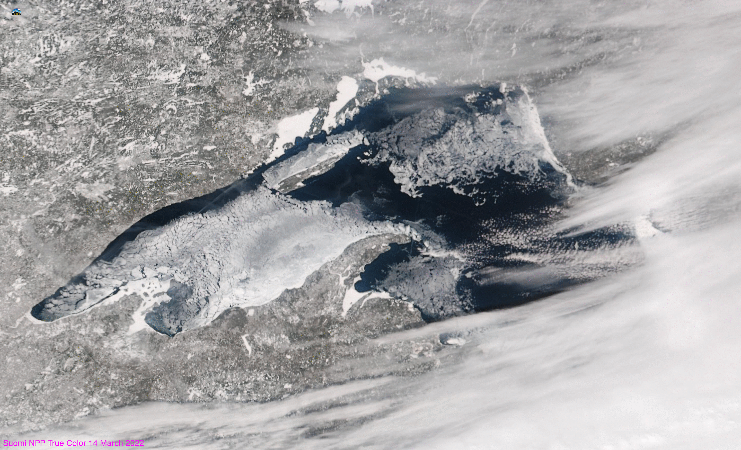
Figure: VIIRS true-color imagery from Suomi-NPP shows ice coverage on Lake Superior has reached a seasonal peak. Mostly clear skies over the lake on Mar. 14, 2022, allowed for better estimates of ice cover. Read more at the CIMSS Satellite Blog: https://cimss.ssec.wisc.edu/satellite-blog/archives/45225. Credit: CIMSS, NOAA.
 (Click image to enlarge)
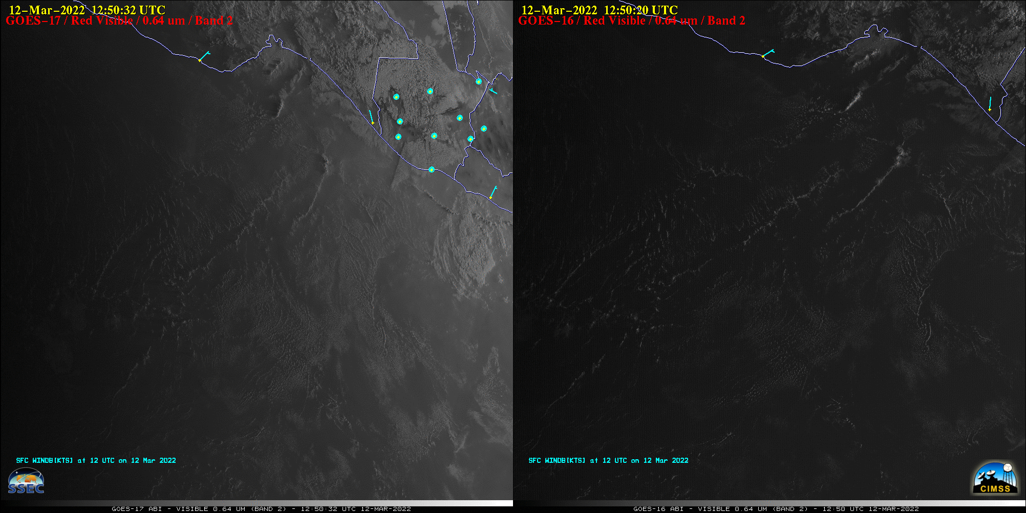
Figure: A strong arctic cold front moved southward across the Gulf of Mexico and southern Mexico on Mar. 12, 2022, emerging from the Chivela Pass as a Tehuano (or “Tehuantepecer“) gap wind that fanned outward across the Gulf of Tehuantepec. Read more at the CIMSS Satellite Blog: https://cimss.ssec.wisc.edu/satellite-blog/archives/45162. Credit: CIMSS, NOAA.
PUBLICATIONS:
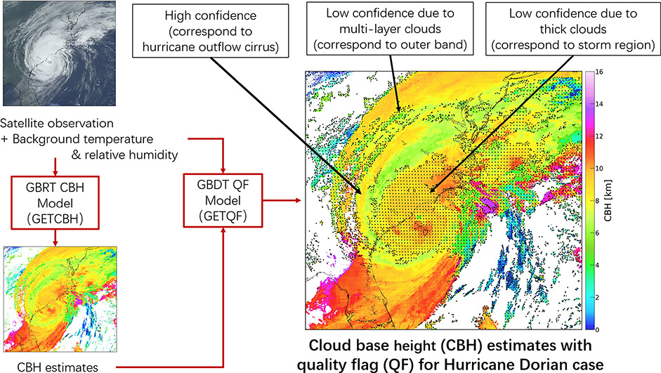
Cloud Base Height Paper Published: A paper titled "Estimate of daytime single-layer cloud base height from Advanced Baseline Imager (ABI) measurements" by Han Lin, Zhenglong Li, Jun Li, Feng Zhang, Min Min, and W. Paul Menzel is published online in Remote Sensing of Environment. In this study, cloud base height (CBH) is retrieved directly from the Geostationary Operational Environmental Satellite-R Series (GOES-R) Advanced Baseline Imager (ABI) level 1b data and the European Centre for Medium-Range Weather Forecasts’ (ECMWF) newly released fifth generation reanalysis (ERA5) data using the Gradient Boosted Regression Trees (GBRT) machine learning technique with CALIPSO/CALIOP data as the label. The evaluations show an overall mean absolute error (MAE) of 1.17 km and an overall root mean square error (RMSE) of 1.87 km before any quality control. After excluding CBH retrievals with low confidence (19.2% of all samples), MAE is reduced to 0.74 km, RMSE to 1.14 km, and the retrieval has a chance of 96% with errors within ± 2 km. Citation: Han Lin, Zhenglong Li, Jun Li, Feng Zhang, Min Min, W. Paul Menzel, Estimate of daytime single-layer cloud base height from advanced baseline imager measurements, Remote Sensing of Environment, Volume 274,2022,112970, https://doi.org/10.1016/j.rse.2022.112970. (Z. Li, CIMSS, 608-890-1982; W.P. Menzel, CIMSS, 608-263-4930)
 (Click image to enlarge)
OTHER:
| Archived Weeklies Page | Submit a report item |