[ Archive ]
| CIMSS-NOAA Weekly Report [ Archive ] |
CIMSS AND ASPB WEEKLY HIGHLIGHTS FOR THE WEEK ENDING APRIL 1, 2022
DATA, INFORMATION, AND USE-INSPIRED SCIENCE:
FUTURE OUTLOOK:
AWARDS AND RECOGNITION:
TRAVEL AND MEETINGS:
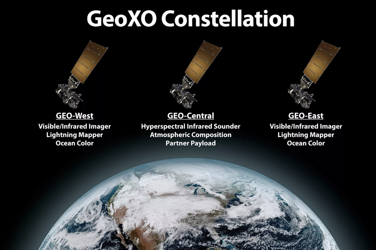
Presentations to the NOAA Pathfinders Initiative Townhall: Scientists from STAR's Cooperative Research Programs (CoRP) Division gave two invited talks at NOAA's Pathfinders Initiative (virtual) townhall on March 28, 2022. S. Rudlosky covered the Geostationary Extended Observations (GeoXO) Lightning Mapper (LMX), while T. Schmit covered the GeoXO Sounder (GXS). Both summarized the many user benefits of the respective instruments. More on the GeoXO is available at https://www.nesdis.noaa.gov/next-generation/geostationary-extended-observations-geoxo. (T. Schmit, E/RA2, 608-263-0291, tim.j.schmit@noaa.gov; S. Rudlosky)
 (Click image to enlarge)
Figure: Current planned Geostationary Extended Observations (GeoXO) constellation, with Lightning Mappers on the wings and a centrally located Sounder.
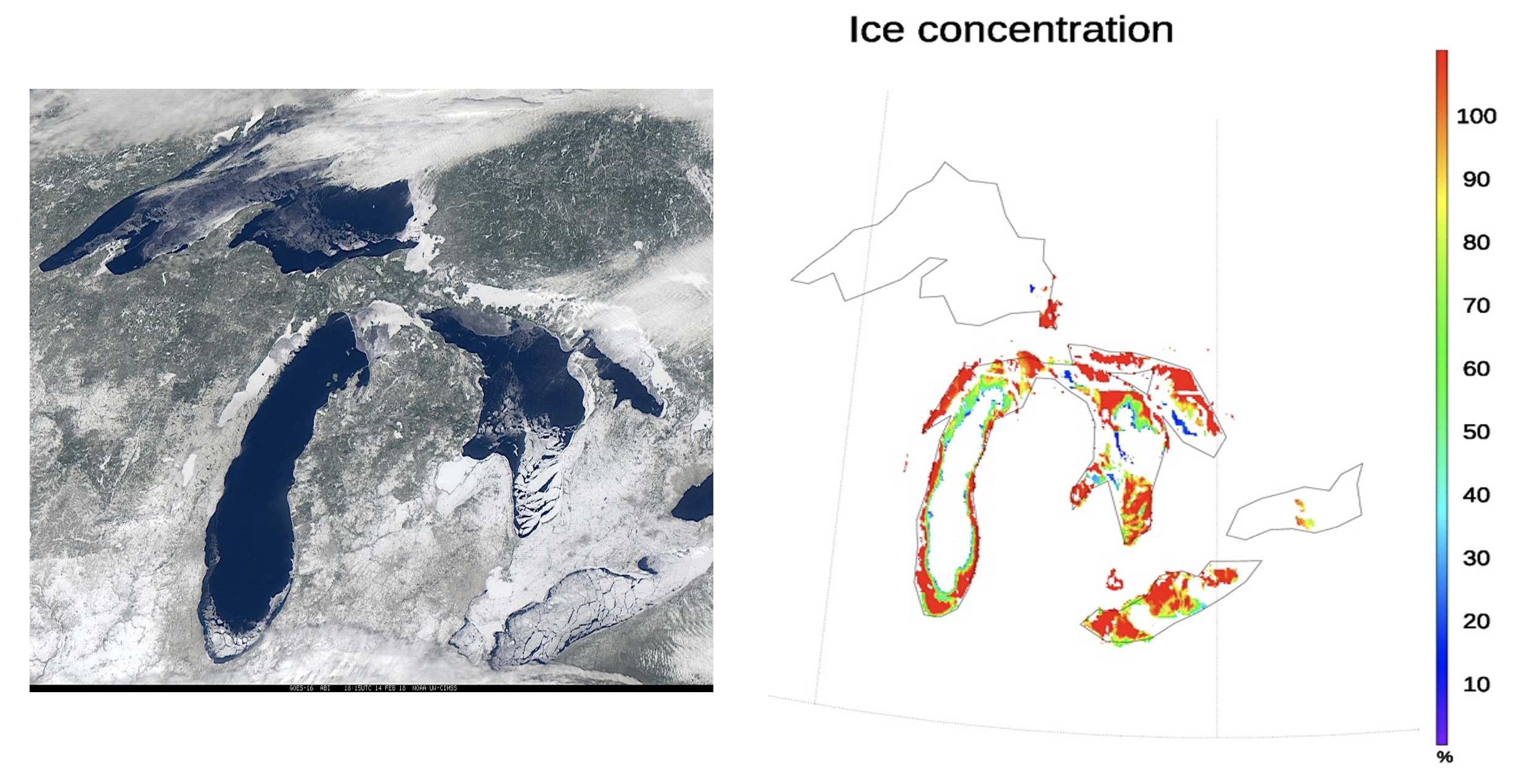
TOWR-S Satellite Book Club Seminar Series on Lake and Sea Ice Detection: Yinghui Liu (STAR) gave a Satellite Book Club seminar sponsored by the NESDIS Total Operational Weather Readiness-Satellites (TOWR-S) team on March 31, 2022. The seminar, titled "Ice Detection and Concentration from JPSS VIIRS and GOES-R ABI", was attended by over 80 people from the National Weather Service, NESDIS, and cooperative institutes. Yinghui talked about algorithms to detect sea and lake ice and to retrieve ice concentration using JPSS VIIRS and GOES-R ABI, their applications and potential improvements. (Y. Liu, E/RA2, 608-890-1893, yinghui.liu@noaa.gov)
 (Click image to enlarge)
Figure: (left) ABI natural-color composite image and (right) derived ice concentration on February 14, 2018 over the Great Lakes.
TRAINING AND EDUCATION:
Update to the VISIT Training on MCVs: Scott Lindstrom from the Cooperative Institute for Meteorological Satellite Studies (CIMSS) updated the Virtual Institute for Satellite Integration Training (VISIT) module on Mesoscale Convective Vortices (MCVs). This reminder training for National Weather Service forecasters is useful for training leading into the warm season. The training is presented as part of the monthly VISIT offerings coordinated through the Forecast Decision Training Division (FDTD) and the Cooperative Institute for Research in the Atmosphere (CIRA). A recorded version of the training is available on Youtube: https://www.youtube.com/watch?v=Y6UJirb9gyY. (S. Lindstrom, CIMSS, 608 263 4425)
MEDIA INTERACTIONS AND REQUESTS:
SOCIAL MEDIA AND BLOG Posts:
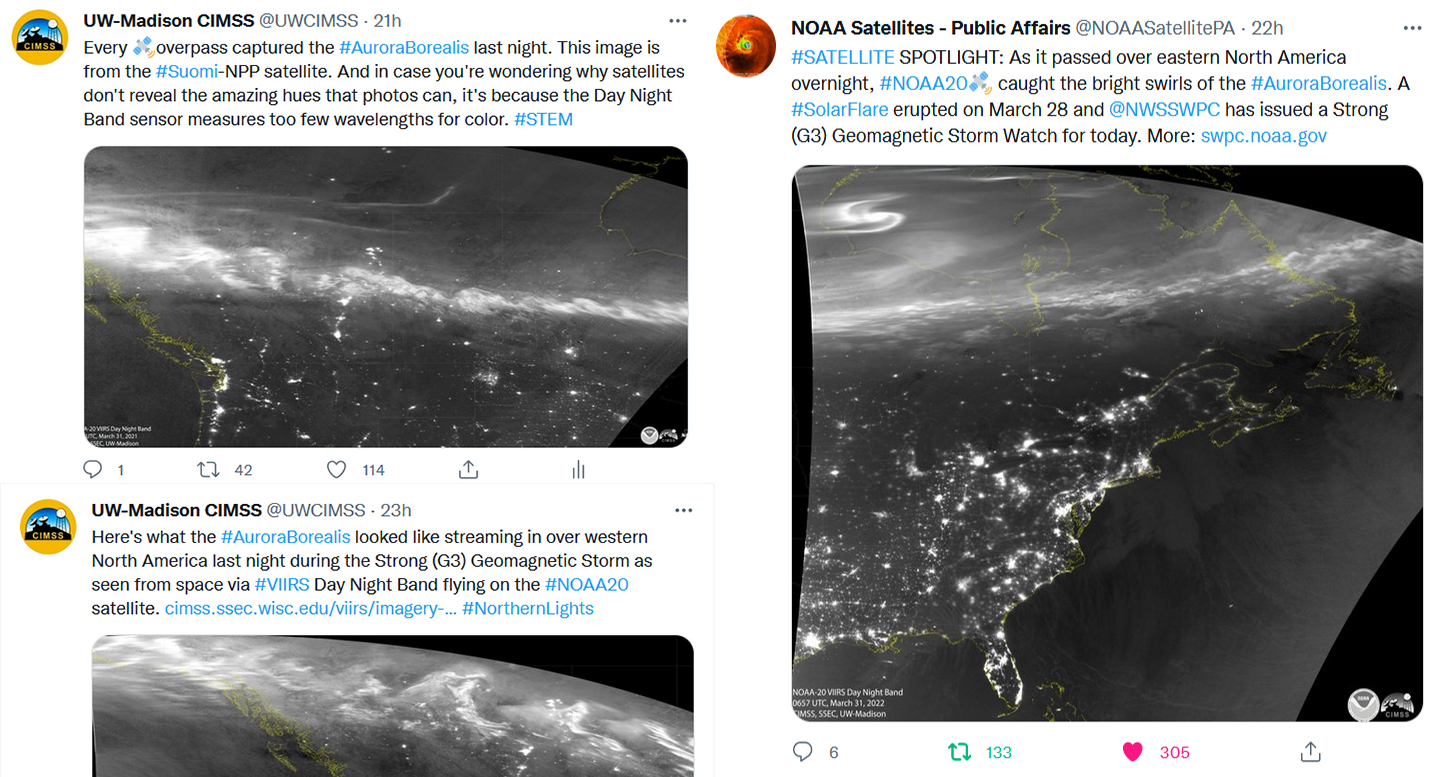
Raising Awareness of NOAA Space Weather via Satellite Images and Social Media: Satellite images of the Aurora Borealis captured by the Visible Infrared Imaging Radiometer Suite (VIIRS) were shared on social media this week in tandem with information about a Geomagnetic Storm Watch issued by NOAA Space Weather Prediction Center. Analytics showed that over one hundred thousand people (> 100,000) viewed or shared the imagery via NOAA Satellites Public Affairs twitter account (@NOAASatellitePA) and NOAA's Cooperative Institute for Meteorological Satellite Studies (CIMSS) social media channels. (M. Mooney, CIMSS, margaret.mooney@ssec.wisc.edu, John Bateman, NOAA Satellite and Information Service)
 (Click image to enlarge)
Figure: VIIRS DNB imagery shared on Twitter.
SSEC and CIMSS Scientists in the News: Scientists at the University of Wisconsin-Madison (UW) Space Science and Engineering Center (SSEC) and the Cooperative Institute for Meteorological Satellite Studies (CIMSS) provide expert interviews, imagery and case studies to promote science. This week: CIMSS Satellite Blog contributors Scott Lindstrom and Scott Bachmeier published these case studies: "Polar Hyperspectral modeling of Severe Weather" (Mar. 30), "Blowing dust from northern Mexico to the Southern Plains" (Mar. 29), "GOES-16 views of snow squalls associated with a multi-vehicle fatal crash in Schuylkill County, Pennsylvania" (Mar. 28), "Crittenburg Complex of wildfires in North Texas" (Mar. 27), "Convective snow shower possibility over Wisconsin/Illinois" (Mar. 25). Read more at the CIMSS Satellite Blog: https://cimss.ssec.wisc.edu/satellite-blog/. (S. Lindstrom, CIMSS, S. Bachmeier, CIMSS, J. Phillips, SSEC, 608-262-8164)
 (Click image to enlarge)
Figure: GOES-16 imagery highlighted the development of widespread blowing dust (brighter shades of pink/magenta) across northern Chihuahua, Mexico and parts of Texas, New Mexico and Oklahoma on Mar. 29, 2022. Read more at the CIMSS Satellite Blog: https://cimss.ssec.wisc.edu/satellite-blog/archives/45479. Credit: CIMSS, NOAA.
PUBLICATIONS:
OTHER:
| Archived Weeklies Page | Submit a report item |