[ Archive ]
| CIMSS-NOAA Weekly Report [ Archive ] |
CIMSS AND ASPB WEEKLY HIGHLIGHTS FOR THE WEEK ENDING APRIL 8, 2022
DATA, INFORMATION, AND USE-INSPIRED SCIENCE:
FUTURE OUTLOOK:
AWARDS AND RECOGNITION:
TRAVEL AND MEETINGS:
TRAINING AND EDUCATION:
New training on ProbSevere Version 3 for the Hazardous Weather Testbed: Scott Lindstrom from the Cooperative Institute for Meteorological Satellite Studies (CIMSS) created a 12-minute training video on the NOAA/CIMSS ProbSevere product (version 3) using information provided by John Cintineo and Justin Sieglaff (CIMSS). ProbSevere (and ProbHail, ProbWind and ProbTor) probabilistically determine (using Multi-Radar Multi-Sensor (MRMS) Radar output, Earth Networks Total Lightning, data from GOES-16's Geostationary Lightning Mapper (GLM) and Advanced Baseline Imager (ABI), and numerical model output as predictors) whether an identified radar object will produce severe weather (or hail, or severe wind, or a tornado) within the next 60 minutes. It is designed to help a forecaster warn with greater confidence and with more lead time. This third version of the product uses a new machine-learning paradigm, and is in general more accurate than previous versions. The recorded version of the training, designed to remind and inform users at the Hazardous Weather Testbed, is available here: https://cimss.ssec.wisc.edu/training/TrainingVideos/ProbSevereV3Recording.mp4. (M. Pavolonis, NOAA/STAR/CIMSS; J. Cintineo, CIMSS; J. Sieglaff, CIMSS; S. Lindstrom, CIMSS, 608 263 4425)
MEDIA INTERACTIONS AND REQUESTS:
SOCIAL MEDIA AND BLOG Posts:
SSEC and CIMSS Scientists in the News: Scientists at the University of Wisconsin-Madison (UW) Space Science and Engineering Center (SSEC) and the Cooperative Institute for Meteorological Satellite Studies (CIMSS) provide expert interviews, imagery and case studies to promote science. This week: 1) The CIMSS Tropical Cyclone Group, in collaboration with the NOAA National Hurricane Center, upgraded the Advanced Dvorak Technique (ADT) ahead of the 2022 Atlantic hurricane season. SSEC News published this story: https://www.ssec.wisc.edu/news/articles/14330. 2) Graduate student research experiences are central to the Polar Radiant Energy in the Far InfraRed Experiment led by CIMSS Director Tristan L'Ecuyer. SSEC News featured three PREFIRE students in different fields who are investigating climate questions: https://www.ssec.wisc.edu/news/articles/14332. 3) CIMSS Satellite Blog contributors Alexa Ross, Scott Lindstrom and Scott Bachmeier published these case studies: "Instrument Flight Rules (IFR) Probability from GOES-17" (April 7), "Grass fire in the Oklahoma Panhandle" (April 5), "Severe weather in South Carolina" (April 5), "Turbulence over the Pacific Ocean northeast of Hawai’i" (April 5), "Deep tropospheric waves over the Gulf of Mexico" (April 4), "Tropical Disturbance south of Guam" (April 4), "Satellite signatures of a SpaceX rocket launch" (April 1), and "Using Polar2Grid and NOAA CLASS VIIRS data to create imagery" (April 1). Read more at the CIMSS Satellite Blog: https://cimss.ssec.wisc.edu/satellite-blog/. (E. Verbeten, SSEC, C. Velden, CIMSS, T. Olander, CIMSS, C. Bloch, T. L'Ecuyer, CIMSS, A. Ross, SSEC, S. Bachmeier, CIMSS, S. Lindstrom, CIMSS, J. Phillips, SSEC, 608-262-8164)
(Click image to enlarge)
Figure: GOES-16 visible imagery showed the development of a tornadic cell near the Georgia/South Carolina border on April 5, 2022. Read more at the CIMSS Satellite Blog: https://cimss.ssec.wisc.edu/satellite-blog/archives/45609. Credit: CSPP Geosphere, CIMSS, NOAA.
PUBLICATIONS:
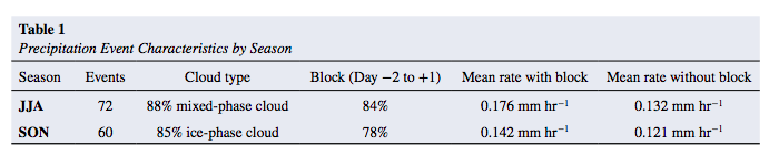
Paper on Greenland Snowfall Published: A new paper demonstrating the connection between atmospheric blocking in the Euro-Atlantic region and snowfall processes over Greenland was published in the Journal of Geophysical Research: Atmospheres titled, "The Critical Role of Euro-Atlantic Blocking in Promoting Snowfall in Central Greenland". The key findings are: 1) The vast majority of enhanced snowfall events observed in central Greenland coincide with Euro-Atlantic blocking. 2) In summer, snowfall is linked to blocking anticyclones over southern Greenland and the advection of warm, moist air from the west. 3) In autumn, snowfall is linked to blocking anticyclones in the Nordic Seas, which steer storms toward southeast Greenland. Co-authors include: Claire Pettersen (University of Michigan/SSEC Honorary Fellow/formerly SSEC/CIMSS), Stephanie Henderson (UW AOS), Kyle Mattingly (SSEC/CIMSS), Ralf Bennartz (SSEC/CIMSS), and Melissa Breeden (NOAA CIRES/formerly SSEC/CIMSS). The paper is available at https://agupubs.onlinelibrary.wiley.com/doi/epdf/10.1029/2021JD035776. Citation: Pettersen, C., Henderson, S. A., Mattingly, K. S., Bennartz, R., & Breeden, M. L. (2022). The critical role of Euro-Atlantic blocking in promoting snowfall in central Greenland. Journal of Geophysical Research: Atmospheres, 127, e2021JD035776, https://doi.org/10.1029/2021JD035776. (C. Pettersen, SSEC)
 (Click image to enlarge)
Figure: Table 1: Precipitation Event Characteristics by Season.
OTHER:
| Archived Weeklies Page | Submit a report item |