[ Archive ]
| CIMSS-NOAA Weekly Report [ Archive ] |
CIMSS AND ASPB WEEKLY HIGHLIGHTS FOR THE WEEK ENDING APRIL 15, 2022
DATA, INFORMATION, AND USE-INSPIRED SCIENCE:
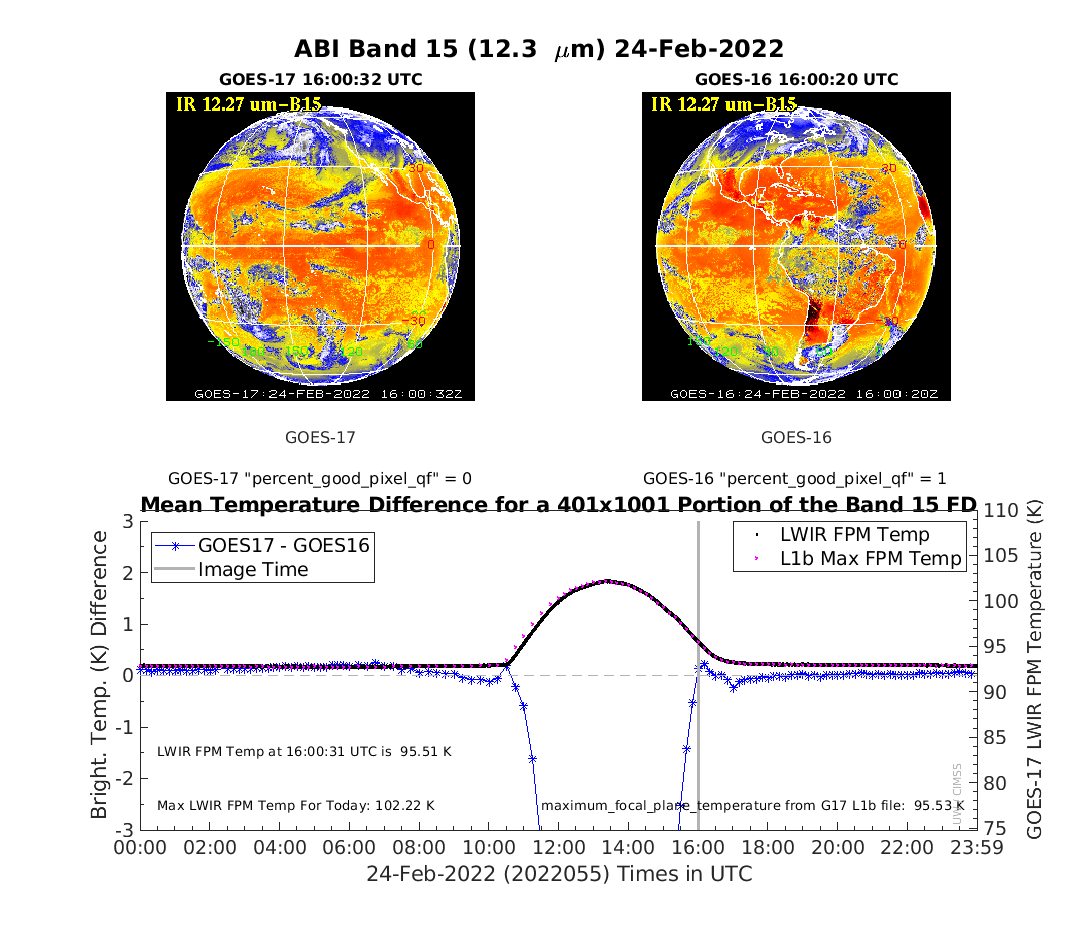
GOES-17 ABI Data Quality Flags Updated for Band 15: Researchers at the Cooperative Institute for Meteorological Satellite Studies (CIMSS) proposed changes to the Advanced Baseline Imager (ABI) Focal Plane Module (FPM) temperature thresholds for Band 15, which were implemented by NESDIS on April 08, 2022. The change was needed for the current GOES-17 warm season where the ABI is being operated at elevated temperatures to minimize the peak temperatures reached during April. Analysis performed by CIMSS in February on test data demonstrated that the data from this band was suitable for both quantitative and qualitative use while the FPM temperature was kept at 93K, similar to the plans for April 2022. Raising the threshold temperature means good, usable data will be noted as such, via Data Quality Flags (DQFs). Had the flags been unchanged band 15 data would have been flagged as unusable for most of the day during the period from April 11-18. More information is available at https://www.ospo.noaa.gov/data/messages/2022/MSG098141504.html. (M. Gunshor, CIMSS, 608-263-1146, T. Schmit, E/RA2, 608-263-0291, tim.j.schmit@noaa.gov)
 (Click image to enlarge)
Figure: GOES-17 minus GOES-16 ABI (GEO-GEO) Band 15 temperature differences show good, stable results through most of the day while operating at a 93 K Focal Plane Module (FPM) setpoint on 24 February 2022.
FUTURE OUTLOOK:
AWARDS AND RECOGNITION:
TRAVEL AND MEETINGS:
TRAINING AND EDUCATION:
Training Created for PHSnABI Modeling Effort for Hazardous Weather Testbed: Scott Lindstrom from the Cooperative Institute for Meteorological Satellite Studies (CIMSS) created a 10-minute training video on the Polar Hyperspectral Sounding and Advanced Baseline Imager (PHSnABI) modeling system that has been developed by Bill Smith, Sr. of CIMSS and Hampton University and by Qi Zhang of Hampton University. This product will be evaluated at the Hazardous Weather Testbed in May and June. Output from this modeling system includes fields of Lifted Index, Significant Tornado Parameter and Convective Available Potential Energy (CAPE), products that a forecaster can use to anticipate where severe convection is most likely to develop. The modeling system uses Data Fusion to combine JPSS Hyperspectral Sounder data with GOES-16 ABI data, taking advantage of the excellent spectral resolution from CrIS/IASI and the excellent temporal/spatial resolution from ABI. A recent example is shown at https://cimss.ssec.wisc.edu/satellite-blog/archives/45745. The training is available online at this YouTube link: https://www.youtube.com/watch?v=ImxooujzHII. (S. Lindstrom, CIMSS, 608 263 4425)
VISIT Training on NUCAPS Profiles: Scott Lindstrom from the Cooperative Institute for Meteorological Satellite Studies (CIMSS) led a Virtual Institute for Satellite Integration Training (VISIT) session on NOAA-Unique Combined Atmospheric Processing System (NUCAPS) profiles in AWIPS. The NUCAPS algorithm combines data from the Cross-track Infrared Sounder (CrIS) and Advanced Technology Microwave Sounder (ATMS) instruments on NOAA-20 to create thermodynamic profiles useful for situational awareness. The training was presented to a member of the Radar Operations Center (ROC) in Norman, OK. (Scott Lindstrom, CIMSS, 608 263 4425)
MEDIA INTERACTIONS AND REQUESTS:
SOCIAL MEDIA AND BLOG Posts:
PUBLICATIONS:
Paper on Changes in Arctic Sea Ice Published: A paper titled, “A New Perspective on Four Decades of Changes in Arctic Sea Ice from Satellite Observations” was published in Remote Sensing. The paper, which was co-authored by Xuanji Wang (University of Wisconsin-Madison), Yinghui Liu (NOAA/NESDIS/STAR), Jeff Key (NOAA/NESDIS/STAR), and Richard Dworak (University of Wisconsin-Madison), introduces a new perspective on the past four decades of changes in Arctic sea ice concentration, extent, thickness, and volume. The paper demonstrates that the loss of the perennial sea ice-covered area is a major factor in the total sea ice loss in all seasons, and that if the current rates of change in ice extent, concentration, and thickness continue, the Arctic is expected to have ice-free summers by the early 2060s. Citation: Wang, X., Y. Liu, J. Key, and R. Dworak, 2022, A new perspective on four decades of changes in Arctic sea ice from satellite observations, Remote Sens., 14, 1846, https://doi.org/10.3390/rs14081846. (Xuanji Wang, UW-Madison, 608-261-1390, xuanjiwang@wisc.edu)
 (Click image to enlarge)
Figure: Monthly mean Arctic sea ice volume in March, 2020.
OTHER:
| Archived Weeklies Page | Submit a report item |