[ Archive ]
| CIMSS-NOAA Weekly Report [ Archive ] |
CIMSS AND ASPB WEEKLY HIGHLIGHTS FOR THE WEEK ENDING APRIL 22, 2022
DATA, INFORMATION, AND USE-INSPIRED SCIENCE:
FUTURE OUTLOOK:
AWARDS AND RECOGNITION:
TRAVEL AND MEETINGS:
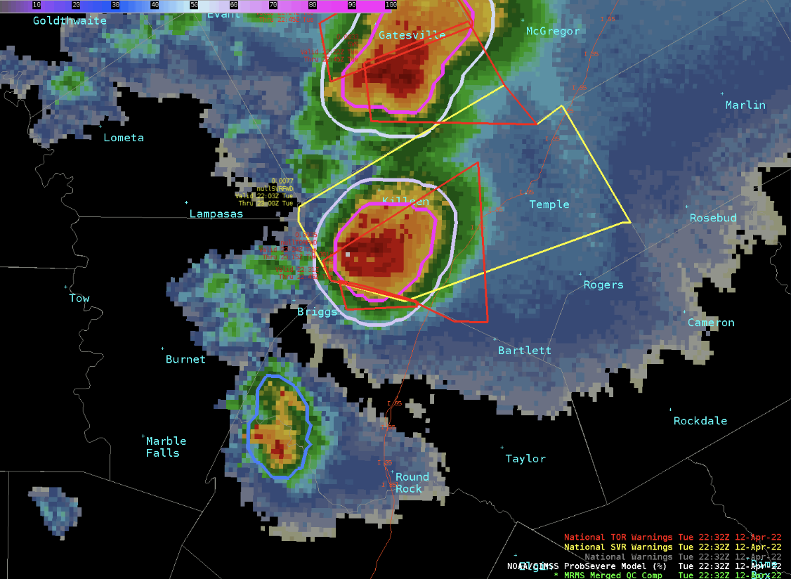
Severe Weather Discussion with NWS Science and Operations Officers: The ProbSevere project team participated in the April 19, 2022 session of the National Weather Service (NWS) Southern Region Science Circle. ProbSevere is an operational tool, developed by NESDIS/STAR and the Cooperative Institute for Meteorological Satellite Studies (CIMSS), that frequently enables NWS forecasters to improve the timeliness and accuracy of severe thunderstorm and tornado warnings. The Science Circle discussion, which started with an interactive briefing on the status of ProbSevere, primarily focused on identifying scenarios that are currently most challenging for severe weather warning operations. The discussion with the more than 70 NWS Science and Operations Officers in (virtual) attendance generated key insights that will help guide the development of ProbSevere v3, which is the latest experimental version. ProbSevere v3 products, which will be evaluated at the 2022 Hazardous Weather Testbed, are available in near-real time at https://cimss.ssec.wisc.edu/severe_conv/psv3.html. (J. Cintineo, CIMSS, M. Pavolonis, E/RA2, 608-263-9597, Mike.Pavolonis@noaa.gov, J. Sieglaff, CIMSS)
 (Click image to enlarge)
Figure: An image of ProbSevere (v3) severe weather probability contours (blue to pink), radar reflectivity, and National Weather Service severe thunderstorm and tornado warnings (yellow and red polygons, respectively) for a storm near Salado, TX, on 12 April 2022. This storm produced a damaging tornado. Learn more about this case at https://goesrhwt.blogspot.com/2022/04/salado-tornado.html.
TRAINING AND EDUCATION:
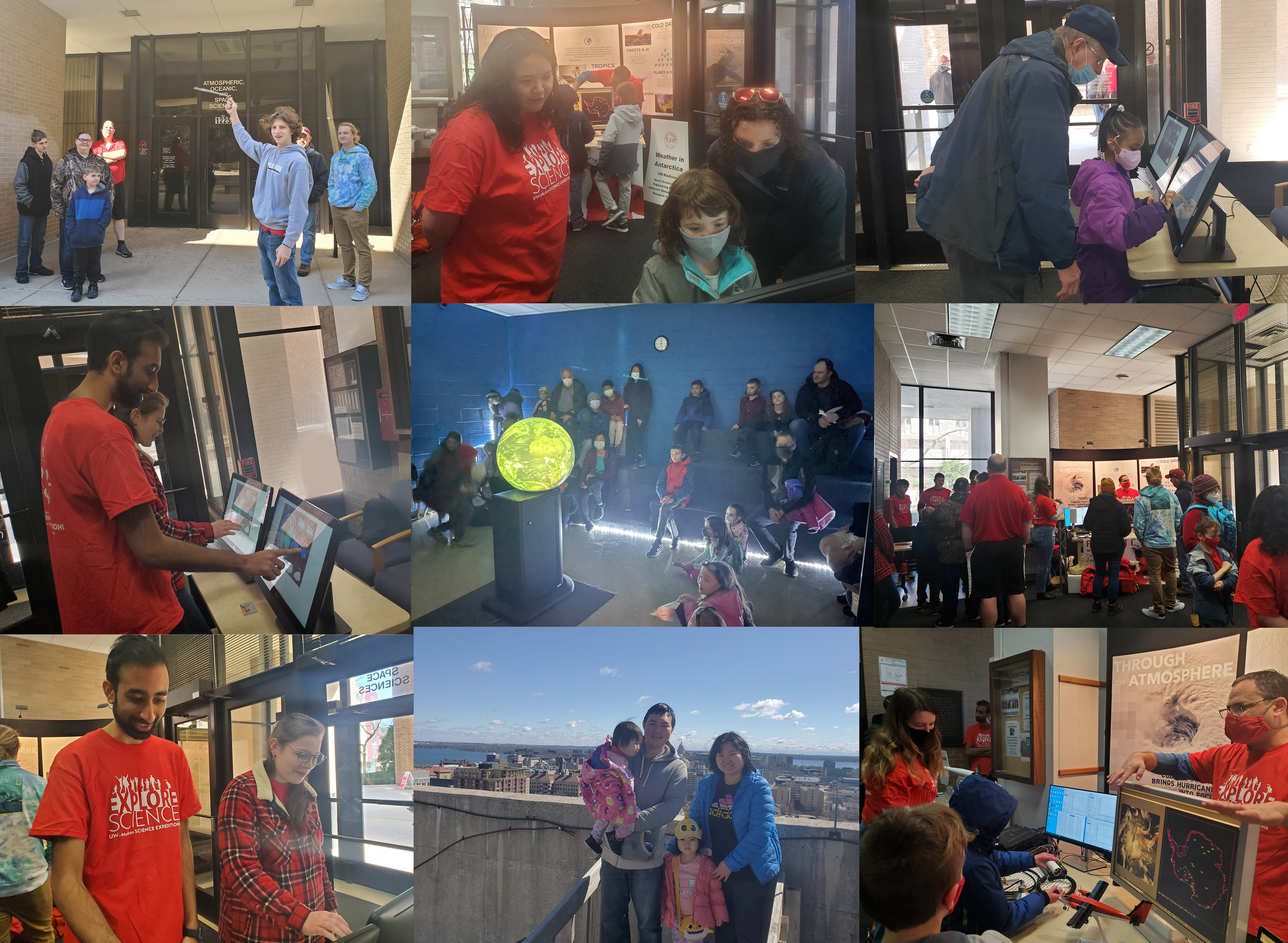
Open House at the Birthplace of Satellite Meteorology: NOAA’s Cooperative Institute for Meteorological Satellite Studies (CIMSS) collaborated with the University of Wisconsin-Madison (UW) Space Science and Engineering Center (SSEC) and Department of Atmospheric and Oceanic Sciences (AOS) to host an open house on Saturday April 9, 2022. Over 300 science-interested individuals attended, young and old. Maintaining a pipeline to the future workforce in geosciences remains a top priority in Madison, Wisconsin. (M. Mooney, CIMSS, A. Ross, SSEC, R. Kohrs, SSEC, J. Mineau, AOS)
 (Click image to enlarge)
Figure: Scenes from the CIMSS/SSEC/AOS Open House.
VISIT Training on LightningCast Probability: Scott Lindstrom from the Cooperative Institute for Meteorological Satellite Studies (CIMSS) gave a Virtual Institute for Satellite Integration Training (VISIT) presentation on LightningCast Probability to two forecasters and the Science and Operations Officer (SOO) at the Buffalo, NY, forecast office (WFO BUF). LightningCast Probability (which will be demonstrated at the Hazardous Weather Testbed, and is available online at this RealEarth-powered website: https://cimss.ssec.wisc.edu/severe_conv/pltg.html) determines the probability of lightning occurring and being observed by the GOES-R Geostationary Lightning Mapper (GLM) in the next 60 minutes based on information from four GOES-16 Advanced Baseline Imager (ABI) channels. (S. Lindstrom, CIMSS, 608 263 4425)
MEDIA INTERACTIONS AND REQUESTS:
SOCIAL MEDIA AND BLOG Posts:
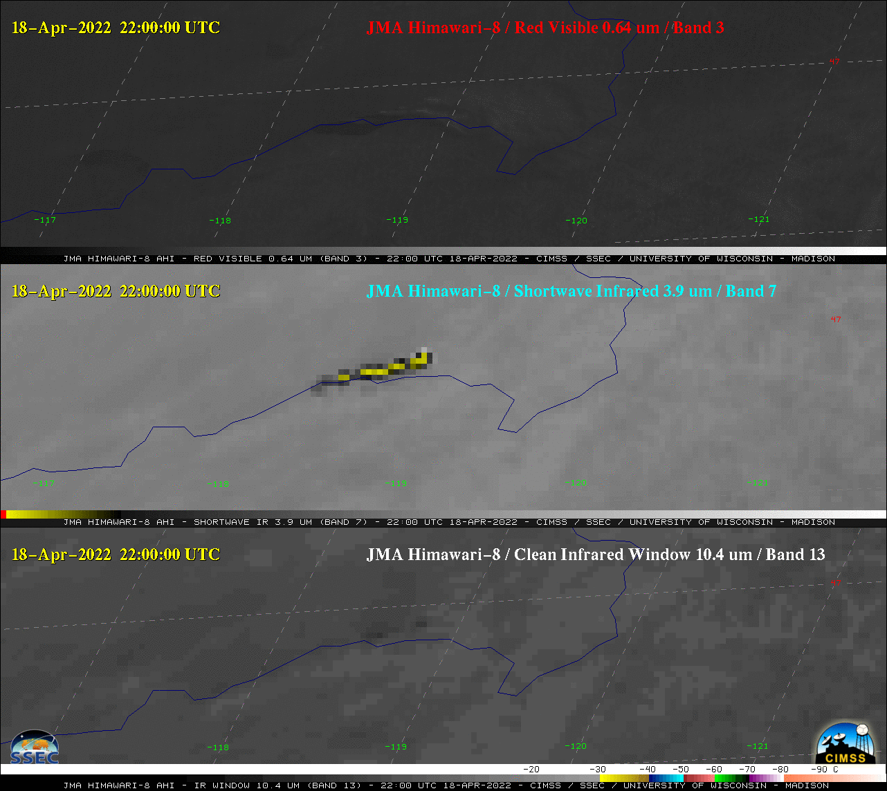
SSEC and CIMSS Scientists in the News: Scientists at the University of Wisconsin-Madison (UW) Space Science and Engineering Center (SSEC) and the Cooperative Institute for Meteorological Satellite Studies (CIMSS) provide expert interviews, imagery and case studies to promote science. This week: 1) The CIMSS Tropical Cyclone Group, in collaboration with NOAA/NESDIS, is operationalizing an upgraded version of the Advanced Dvorak Technique (ADT) in time for the 2022 Atlantic hurricane season. UW News picked up the SSEC story and CNN Weather interviewed CIMSS scientist Tim Olander for a story set to run on April 23, 2022: https://news.wisc.edu/uw-hurricane-application-gets-upgrade-in-time-for-2022-hurricane-season/. 2) "Spring Fire on the Steppe" of eastern Mongolia by NASA Earth Observatory further explains a blog post by CIMSS scientist Scott Bachmeier about the fire and the pyrocumulonimbus cloud it produced. Read more: https://earthobservatory.nasa.gov/images/149741/spring-fire-on-the-steppe. 3) A New York Times story on the Tonga Volcano eruption includes a link to a GOES-17, mid-level water vapor animation of the shockwave it produced. NOAA scientist Tim Schmit provided the animation. Read more at NYT: https://www.nytimes.com/interactive/2022/04/14/upshot/tonga-pressure-wave.html. See the animation at https://go.wisc.edu/8urni8. 4) CIMSS Satellite Blog contributors Scott Lindstrom and Scott Bachmeier published these case studies: "Parallax with GOES-R and VIIRS Fire Detection" (April 21), "Tunnel Fire in Arizona" (April 20), "Grassland fire in Mongolia generates a pyrocumulonimbus cloud" (April 19), "GOES-17 imagery and a cooler Set Point temperature" (April 19), "NUCAPS fields over American Samoa" (April 19), "A month of Himawari imagery over Guam" (April 18), "Severe thunderstorms move from southern Missouri into northeastern Arkansas" (April 15), "Blowing snow across the North Slope of Alaska" (April 15),"ACSPO SSTs from Himawari-8 in AWIPS" (April 15), and "GOES-17 Image Degradation due to a warmer Set Point temperature" (April 15). Read more at the CIMSS Satellite Blog: https://cimss.ssec.wisc.edu/satellite-blog/. (E. Verbeten, SSEC, C. Velden, CIMSS, T. Olander, CIMSS, S. Bachmeier, CIMSS, T. Schmit, E/RA2, S. Lindstrom, CIMSS, J. Phillips, SSEC, 608-262-8164)
 (Click image to enlarge)
Figure: JMA Himawari-8 images of a grassland fire in eastern Mongolia that produced a pyrocumulonimbus cloud. Read more at the CIMSS Satellite Blog and NASA Earth Observatory: https://cimss.ssec.wisc.edu/satellite-blog/archives/45845, https://earthobservatory.nasa.gov/images/149741/spring-fire-on-the-steppe. Credit: JMA, CIMSS.
PUBLICATIONS:
OTHER:
| Archived Weeklies Page | Submit a report item |