[ Archive ]
| CIMSS-NOAA Weekly Report [ Archive ] |
CIMSS AND ASPB WEEKLY HIGHLIGHTS FOR THE WEEK ENDING MAY 6, 2022
DATA, INFORMATION, AND USE-INSPIRED SCIENCE:
FUTURE OUTLOOK:
AWARDS AND RECOGNITION:
TRAVEL AND MEETINGS:
Presentation on SAR Wind observations at the Great Lakes Operational Meteorology Workshop (GLOMW): Scott Lindstrom from the Cooperative Institute for Meteorological Satellite Studies (CIMSS) gave a talk on the utility of Synthetic Aperture Radar (SAR) wind observations (that are mostly from Canada's RADARSAT Constellation Mission (RCM)'s three satellites) at the Great Lakes Operational Meteorology Workshop (GLOMW), a joint NOAA/NWS and Environment and Climate Change Canada (ECCC)-sponsored remote workshop. The 20-minute talk highlighted examples of SAR data from the CIMSS Satellite Blog (https://cimss.ssec.wisc.edu/satellite-blog/?s=SAR+Winds) and was the final talk on the first day of the 4-day workshop. (S. Lindstrom, CIMSS, 608 263 4425)
CIMSS Participation in Pacific International Training Desk webinar: Scott Lindstrom from the Cooperative Institute for Meteorological Satellite Studies (CIMSS) and Wm. Brandon Aydlett, the Science and Operations Officer (SOO) at the National Weather Service forecast office in Guam, jointly gave a presentation titled "Application of the NOAA-Unique Combined Atmospheric Processing System (NUCAPS) to the Tropical Pacific" for a monthly seminar series coordinated by the Pacific International Training Desk (PITD) at the University of Hawai'i -- Manoa. Scott gave background information on hyperspectral soundings, starting with data from the Atmospheric Infrared Sounder (AIRS) on Aqua, and proceeding to the Infrared Atmospheric Sounding Interferometer (IASI) on the Metop series of polar orbiters and then the Cross-Track Infrared Sounder (CrIS) on Suomi-NPP/NOAA-20, and discussed how NUCAPS profiles are created. Brandon then showed examples for NUCAPS uses over the tropical Pacific in both northern and southern Hemispheres, with an especial focus on moisture. The presentation was streamed via both Zoom and Facebook Live; a recorded version is available at the Pacific Desk. (S. Lindstrom, CIMSS, 608 263 4425)
TRAINING AND EDUCATION:
MEDIA INTERACTIONS AND REQUESTS:
SOCIAL MEDIA AND BLOG Posts:
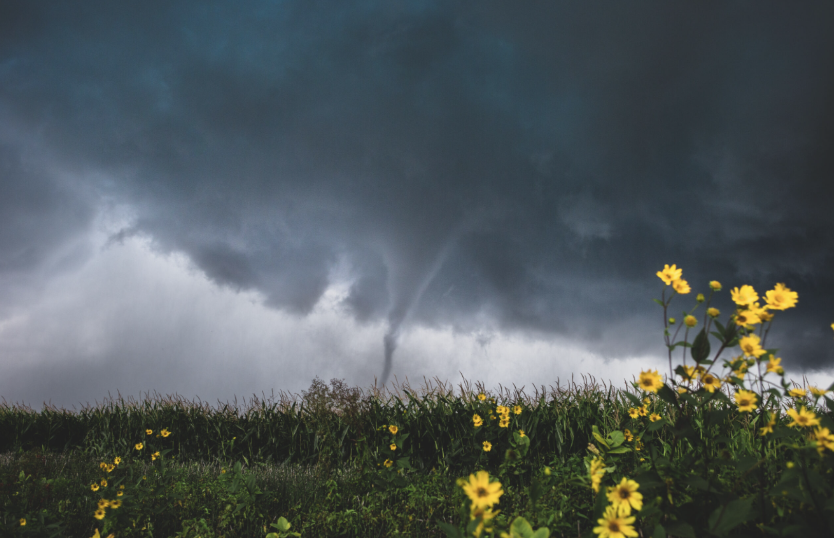
SSEC and CIMSS Scientists in the News: Scientists at the University of Wisconsin-Madison (UW) Space Science and Engineering Center (SSEC) and the Cooperative Institute for Meteorological Satellite Studies (CIMSS) provide expert interviews, imagery and case studies to promote science. This week: 1) Results of the 2022 Atmospheric, Oceanic and Space Sciences Photo Contest are in: Department of Atmospheric and Oceanic Sciences student Isaac Schluesche won first place with a photograph of the formation of a tornado near Greene, Iowa. SSEC News published this story: https://www.ssec.wisc.edu/news/articles/14487/. 2) CIMSS Satellite Blog contributors Alexa Ross, Scott Lindstrom and Scott Bachmeier published these case studies: "Calf Canyon and Hermits Peak Fires continue in New Mexico" (May 5), "SAR data over Hawai’i" (May 5), "SAR Observations of Red River of the North Flooding" (May 5), "First thunderstorm of the season in the Anchorage, Alaska area" (May 4), "Comparisons of LIS and GLM Lightning observations" (May 4), "Persistent fog/stratus across eastern Virginia" (May 3), "Ongoing flooding along the Red River of the North" (May 3), "GOES-16 and GOES-17 Full-Disk IFR/Low IFR Probability fields are now available in RealEarth" (May 3), "Preview of Coming Attractions: the new CSPP Geosphere site" (May 2), and "Hermits Peak / Calf Canyon Fire in New Mexico generates a pyrocumulonimbus cloud" (May 1). Read more at the CIMSS Satellite Blog: https://cimss.ssec.wisc.edu/satellite-blog/. (E. Verbeten, SSEC, K. Johnson, SSEC, A. Ross, SSEC, S. Lindstrom, CIMSS, S. Bachmeier, CIMSS, J. Phillips, SSEC, 608-262-8164)
 (Click image to enlarge)
Figure: 2022 AOSS Photo Contest 1st place entry: EF1 @ F/4.5, Greene, Iowa, Aug. 27, 2021 by Isaac Schluesche, photographer. Read more: https://www.ssec.wisc.edu/news/articles/14487/.
(Click image to enlarge)
Figure: With an anticipated release of Summer 2022, the new CSPP Geosphere site — being tested now at CIMSS — includes GOES-17 data and will later include GOES-18 data. Users will be able to create imagery over the Pacific Ocean, including Hawaii, as in this animation. Read more at the CIMSS Satellite Blog: https://cimss.ssec.wisc.edu/satellite-blog/archives/46062. Credit: CIMSS, NOAA.
PUBLICATIONS:
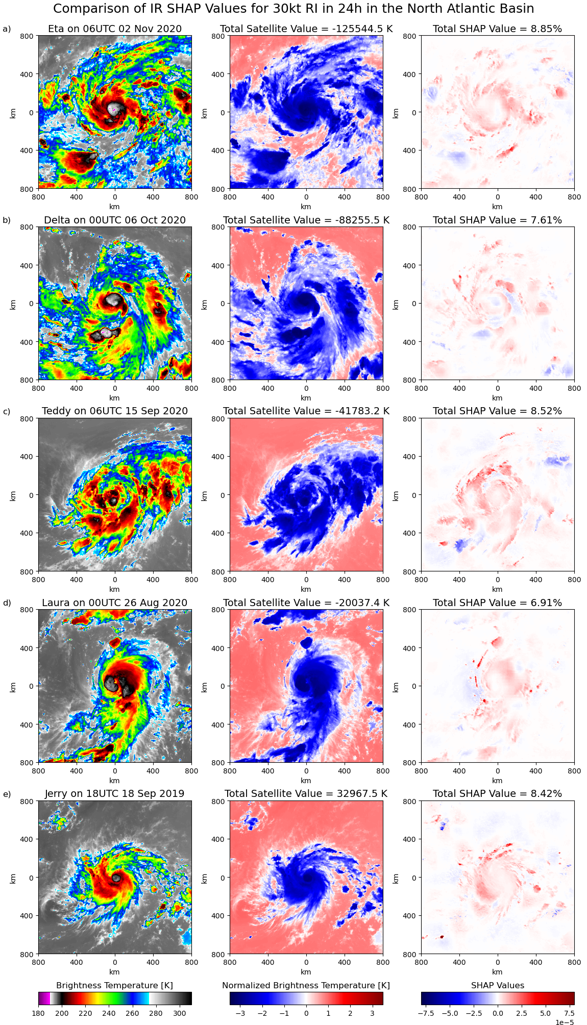
Accepted Paper Predicting Tropical Cyclone Rapid Intensification using AI: A paper predicting tropical cyclone (TC) rapid intensification (RI) by Sarah Griffin, Tony Wimmers, and Chris Velden has been accepted for publication in Weather and Forecasting. This paper uses satellite data and environmental scalar predictors available from the National Hurricane Center (NHC) in a convolutional neural network, coined AI-RI. In a 2019 and 2020 North Atlantic TCs, AI-RI was more skillful than the operational RI models for three out of eight RI thresholds, while averaging the Ri probability from AI-RI with the operational RI models increased the forecast skill for two additional RI thresholds. In 2019 and 2020 eastern North Pacific TCs, AI-RI was more skillful than the operational RI models for only 1 RI threshold, but was more skillful for 5 RI thresholds for TCs north of 15 degrees latitude. In addition, SHapley Additive exPlanation (SHAP) values are used to identify the impact of different inputs (called features) into AI-RI on the probability of RI. It was found that satellite features had the highest impact on the RI probability. The highest SHAP values in the satellite features are associated with isolated cold brightness temperatures, with texture clearly indicating convection. (S. Griffin, CIMSS)
 (Click image to enlarge)
Figure: IR data for a given RI forecast, normalized IR data for AI-RI, and corresponding SHAP values for 5 TCs which underwent 30-kt RI in the North Atlantic Basin.
OTHER:
| Archived Weeklies Page | Submit a report item |