[ Archive ]
| CIMSS-NOAA Weekly Report [ Archive ] |
CIMSS AND ASPB WEEKLY HIGHLIGHTS FOR THE WEEK ENDING MAY 13, 2022
DATA, INFORMATION, AND USE-INSPIRED SCIENCE:
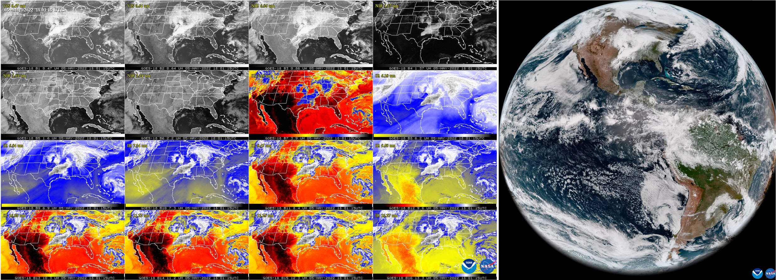
GOES-18 ABI First Light: The GOES-R Algorithm Working Group (AWG) Imagery Team provided imagery and image animations for the NOAA GOES-18 Advanced Baseline Imager (ABI) first light imagery debut, which appeared as an Earth From Orbit video on May 11, 2022 (https://www.nesdis.noaa.gov/news/earth-orbit-noaa-debuts-first-imagery-goes-18) completing a major team milestone. These images were generated using data primarily from May 5 in a collaborative effort between the Cooperative Institute for Meteorological Satellite Studies (CIMSS), the Cooperative Institute for Research in the Atmosphere (CIRA), and NOAA/NESDIS/STAR scientists collocated at the cooperative institutes. GOES-18 imagery appears in several CIMSS Satellite Blog entries (https://cimss.ssec.wisc.edu/satellite-blog/archives/category/goes-18). The images and animations were widely featured on social media. (M. Gunshor, CIMSS, 608-263-1146, T. Schmit, E/RA2, 608-263-0291, tim.j.schmit@noaa.gov)
 (Click image to enlarge)
Figure: The GOES-R Advanced Baseline Imager (ABI) First Light Images from the NOAA GOES-18 Image Debut with all 16 bands of the ABI shown over the Contiguous United States (CONUS) in the 16 panel on the left (credit CIMSS) and the GeoColor” full disk image on the right (credit CIRA).
FUTURE OUTLOOK:
AWARDS AND RECOGNITION:
TRAVEL AND MEETINGS:
TRAINING AND EDUCATION:
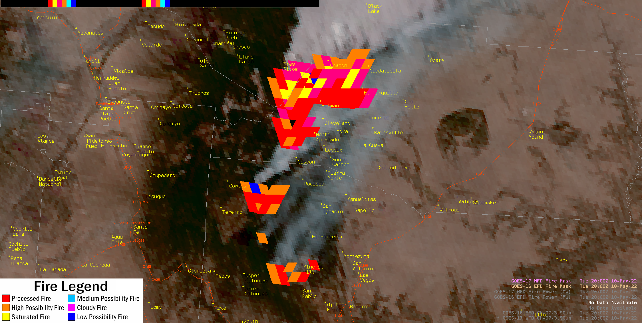
GOES-16/-17 Fires Presentation at the Satellite Book Club Seminar Series: Chris Schmidt of the Cooperative Institute for Meteorological Satellite Studies (CIMSS) discussed the use and interpretation of the Geostationary Operational Environmental Satellite (GOES) Advanced Baseline Imager (ABI) Fire Detection and Characterization Algorithm (FDCA) product at the Satellite Book Club (SBC) Seminar Series. The SBC is hosted by the Total Operational Weather Readiness-Satellites (TOWR-S) Team from the National Weather Weather Service (NWS) Office of Observations. "Making Use and Sense of the ABI Fire Detection and Characterization Algorithm Data" addressed issues raised by forecasters as they have used the FDCA product, such as why GOES-16 and GOES-17 see fires differently, quirks in the Advanced Weather Interactive Processing System (AWIPS) presentation of the FDCA data, the impact of terrain on perceived fire location, why some fires don't appear, and the causes of common false positives detections. The figure below is an AWIPS screenshot of GOES-16 and GOES-17 FDCA fires in New Mexico on 10 May 2022 overlaid on the GeoColor product. The offsets in the fire masks are not errors in navigation, but rather they reflect the effects of terrain on the perceived location of the fires, an issue that users such as NWS forecasters must take into account when interpreting imagery. Paradoxically, the GOES-17 fires appear shifted to the east from their true locations, and GOES-16 fires appear shifted to the west. Corrections for the terrain offsets are in development. The presentation was recorded and can be found on the SBC's Youtube page at https://youtu.be/vjxliyRNfyk. (C. Schmidt, CIMSS, 608-262-7973)
 (Click image to enlarge)
Figure: AWIPS screenshot of GOES-16 and GOES-17 FDCA fires in New Mexico on 10 May 2022 overlaid on the GeoColor product.
CIMSS Satellite Training for the Green Bay Weather Forecast Office: Scott Lindstrom from the Cooperative Institute for Meteorological Satellite Studies (CIMSS) provided a 1-hour live (but remote) training for forecasters and the Science and Operations Officer (SOO) at the Green Bay forecast office of the National Weather Service (WFO GRB). This was a Spring Severe Season reminder training session. The topics included NOAA-Unique Combined Atmospheric Processing System (NUCAPS) Profiles, Geostationary Lightning Mapper (GLM) data, NOAA/CIMSS ProbSevere (versions 2 and 3) and LightningCast Probabilities. The training was done at the request of the SOO in Green Bay. (S. Lindstrom, CIMSS, 608 263 4425)
MEDIA INTERACTIONS AND REQUESTS:
SOCIAL MEDIA AND BLOG Posts:
SSEC and CIMSS Scientists in the News: Scientists at the University of Wisconsin-Madison (UW) Space Science and Engineering Center (SSEC) and the Cooperative Institute for Meteorological Satellite Studies (CIMSS) provide expert interviews, imagery and case studies to promote science. This week: 1) SSEC News published, "GOES-18: First images of Earth from newest weather satellite." Read more: https://www.ssec.wisc.edu/news/articles/14497/. 2) CIMSS Satellite Blog contributors Tim Schmit, Alexa Ross, Scott Lindstrom, Scott Bachmeier and John Cintineo published these case studies: "GOES-18 ABI Imagery Comparisons" (May 13), "GOES-16 GLM Lightning detection over Minnesota" (May 12), "Early ABI Images from GOES-18" (May 12), "Severe thunderstorms across the Upper Midwest" (May 11), "Wildfire signatures viewed by GOES-17, GOES-18 and GOES-16" (May 11), "Using the Night Microphysics RGB and LightningCast probabilities to anticipate nighttime convection and Lightning" (May 11), "Calf Canyon Fire produces a pyrocumulonimbus cloud" (May 10), "Day Night Band Imagery of fires in New Mexico" (May 10), "Bolt out of the blue" (May 10), "Hail in Portland OR" (May 9), and "Wildfires and blowing dust in New Mexico" (May 8). Read more at the CIMSS Satellite Blog: https://cimss.ssec.wisc.edu/satellite-blog/. (T. L'Ecuyer, CIMSS, T. Schmit, E/RA2, A. Ross, SSEC, S. Lindstrom, CIMSS, S. Bachmeier, CIMSS, J. Cintineo, CIMSS, J. Phillips, SSEC, 608-262-8164)
(Click image to enlarge)
Figure: A true color composite image, along with all 16 spectral bands from the preliminary, non-operational GOES-18 Advanced Baseline Imager on May 5, 2022. Read more at the CIMSS Satellite Blog: https://cimss.ssec.wisc.edu/satellite-blog/archives/46085. Credit: CIMSS, NOAA.
(Click image to enlarge)
Figure: The GOES-16 Geostationary Lightning Mapper detected lightning extent density over parts of South Dakota, Iowa and Wisconsin during a storm that struck the region on May 11, 2022. Read more at the CIMSS Satellite Blog: https://cimss.ssec.wisc.edu/satellite-blog/archives/46280. Credit: RealEarth, SSEC, CIMSS, NOAA.
PUBLICATIONS:
OTHER:
| Archived Weeklies Page | Submit a report item |