[ Archive ]
| CIMSS-NOAA Weekly Report [ Archive ] |
CIMSS AND ASPB WEEKLY HIGHLIGHTS FOR THE WEEK ENDING MAY 20, 2022
DATA, INFORMATION, AND USE-INSPIRED SCIENCE:
FUTURE OUTLOOK:
AWARDS AND RECOGNITION:
TRAVEL AND MEETINGS:
Presentation at EUMETSAT Convection Group Workshop: A paper entitled "Recent Enhancements, Applications and Validation of CIMSS NearCasts" by Ralph A. Petersen and Lee M. Cronce was presented virtually at the EUMETSAT Convection Working Group (CWG) Workshop held between 16-20 May 2022 in Budapest Hungary. The talk included a new approach for reducing satellite moisture product biases using existing ground-truth Total Precipitable Water for validation. (R. Petersen, CIMSS, 262-763-2583, L. Cronce, CIMSS, 608-265-6282).
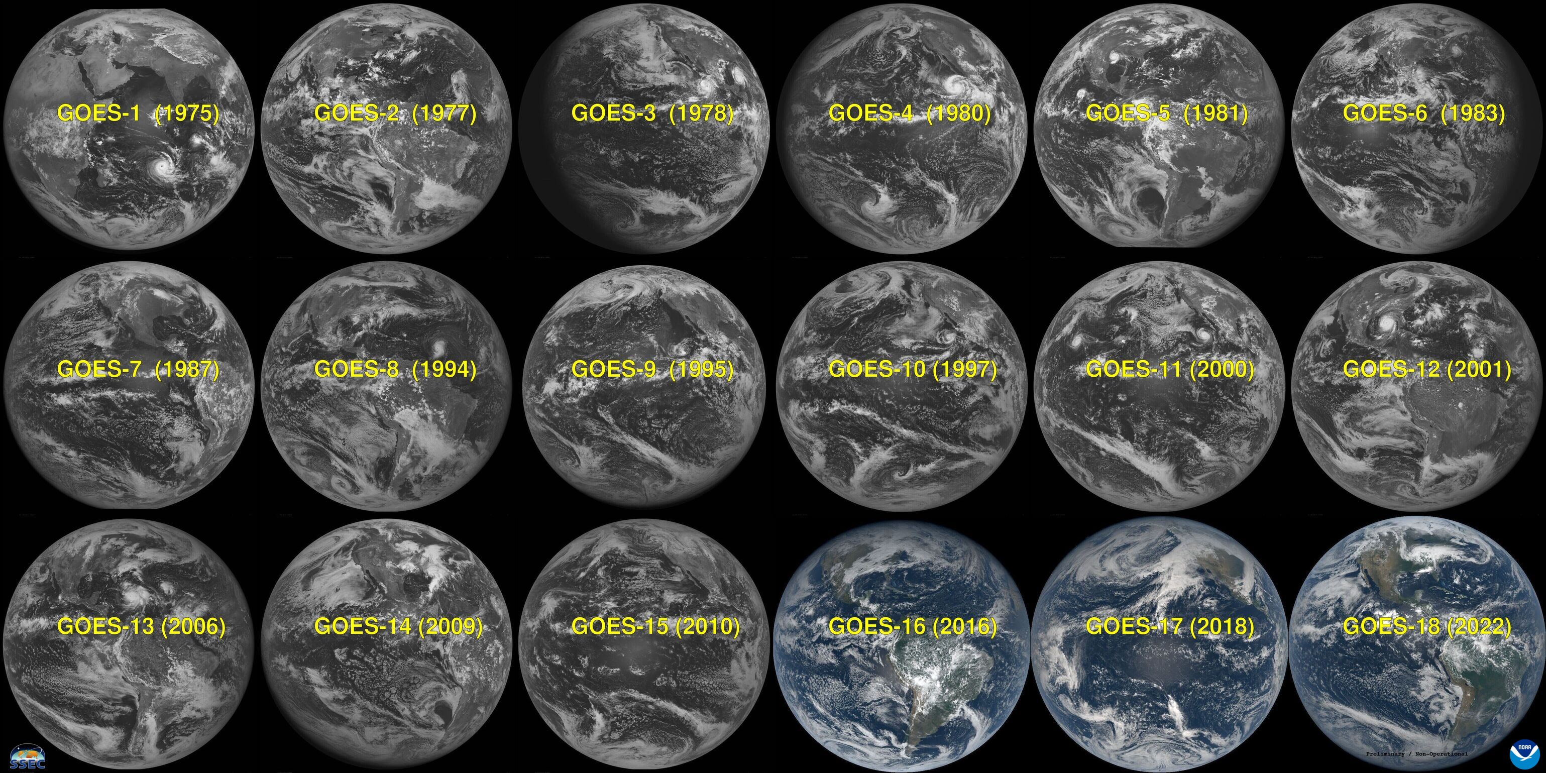
GOES-18 Imagery Presentation at a Satellite Book Club Seminar: T. Schmit of the NOAA/NESDIS Advanced Satellite Products Branch (ASPB) showcased Geostationary Operational Environmental Satellite (GOES)-18 Advanced Baseline Imager (ABI) images at the virtual Satellite Book Club (SBC) Seminar Series. The SBC is hosted by the Total Operational Weather Readiness-Satellites (TOWR-S) Team from the National Weather Weather Service (NWS) Office of Observations. The presentation included an update on the status of the GOES-18 ABI, along with first light (preliminary, non-operational) imagery (single bands and composites, as well as many side-by-side comparisons). The plans for the second part of the post-launch test of GOES-18 was covered, and plans for operations. Many of the imagery comparisons can be found in this CIMSS Satellite Blog post at https://cimss.ssec.wisc.edu/satellite-blog/archives/46087. (T. Schmit, E/RA2, 608-263-0291)
 (Click image to enlarge)
Figure: GOES-18 (Preliminary, non-operational) joins the GOES family, which started in 1975 with GOES-1. GOES-16/18 have both a ‘blue’ visible band and ‘vegetation’ band, and hence those images are shown in color.
TRAINING AND EDUCATION:
CIMSS Graduate Student Anthony Bernal Ayala Completes NOAA Internship: University of Wisconsin - Madison Atmospheric Oceanic Sciences (AOS) and Cooperative Institute for Meteorological Satellite Studies (CIMSS) PhD graduate student Anthony Bernal Ayala, completed a NOAA National Weather Service Office of Observations internship during 2021-2022. Michelle Mainelli, Acting Director of the Office of Observations, sent a letter to him stating "Your geostationary satellite parallax research demonstrated your focus and attention to detail, a willingness to learn and explore new areas in operational meteorology, and strong, clear communication and presentation skills. Developing new satellite applications is an important role of the Office of Observations to serve our field offices." The letter also congratulated him with his ability to adapt to the virtual work environment and to consider a physical scientist position in NOAA as a career. (T. L'Ecuyer, CIMSS Director, 608-890-2107, W. Feltz, CIMSS, 608-265-6283)
MEDIA INTERACTIONS AND REQUESTS:
SOCIAL MEDIA AND BLOG Posts:
SSEC and CIMSS Scientists in the News: Scientists at the University of Wisconsin-Madison (UW) Space Science and Engineering Center (SSEC) and the Cooperative Institute for Meteorological Satellite Studies (CIMSS) provide expert interviews, imagery and case studies to promote science. This week: CIMSS Satellite Blog contributors Scott Lindstrom, Mathew Gunshor, Scott Bachmeier and Tim Schmit published these case studies: "SAR wind data off the Pacific coast" (May 19), "GOES World" (May 18), "Fog in and around the Aleutians" (May 18), "Another pyrocumulonimbus cloud spawned by the Calf Canyon Fire in New Mexico" (May 14), "Polar hyperspectral modeling for a narrow line of convection" (May 13) and "GOES-18 ABI Imagery Comparisons" (May 13). Read more at the CIMSS Satellite Blog: https://cimss.ssec.wisc.edu/satellite-blog/. (S. Lindstrom, CIMSS, M. Gunshor, CIMSS, S. Bachmeier, CIMSS, T. Schmit, E/RA2)
 (Click image to enlarge)
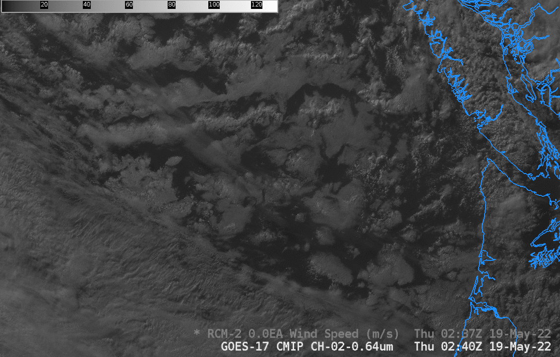
Figure: Synthetic Aperture Radar winds and GOES-17 imagery over the Pacific Ocean on May 19, 2022 highlighting advantages of using SAR imagery to provide high-resolution observations of winds in regions where those observations might otherwise be sparse or non-existent. Read more at the CIMSS Satellite Blog: https://cimss.ssec.wisc.edu/satellite-blog/archives/46427. Credit: CIMSS, NOAA, RCM2.
 (Click image to enlarge)
Figure: CIMSS natural color image at local noon on May 15, 2022 incorporates Advanced Baseline Imager data from GOES-17, GOES-18 (Preliminary/non-operational) and GOES-16. Read more at the CIMSS Satellite Blog: https://cimss.ssec.wisc.edu/satellite-blog/archives/46413. Credit: R. Kohrs, SSEC, CIMSS, NOAA.
PUBLICATIONS:
OTHER:
| Archived Weeklies Page | Submit a report item |