[ Archive ]
| CIMSS-NOAA Weekly Report [ Archive ] |
CIMSS AND ASPB WEEKLY HIGHLIGHTS FOR THE WEEK ENDING MAY 27, 2022
DATA, INFORMATION, AND USE-INSPIRED SCIENCE:
Report on GOES-18 Post Launch Test Submitted: A report was submitted to the GOES-R Program on the GND-006 GOES-18 post launch test. The test involved sending products from multiple GOES-R Series satellites in a single “interleaved” data stream relayed via GOES-18. Interleaving is planned in the GOES-West GOES Rebroadcast (GRB) stream starting on August 1, with GOES-18 Advanced Baseline Imager (ABI) data replacing GOES-17 ABI during periods of quality degradation. During the test, Cooperative Institute for Meterological Satellite Studies (CIMSS) received the data on a local antenna, providing live feedback to the Ground System Team, and tested CSPP (Community Satellite Processing Package) Geo ingestor software, which is developed and maintained at CIMSS for direct broadcast users. The report concluded that GND-006 had been a successful demonstration of GOES-18 GRB capabilities and the interleaving approach, and that the current version of the CSPP Geo ingestor package is capable of processing an interleaved data stream. (G. Martin, CIMSS, T. Jasmin, CIMSS, N. Bearson, CIMSS, D. Forrest, SSEC, D. Schumacher, SSEC)
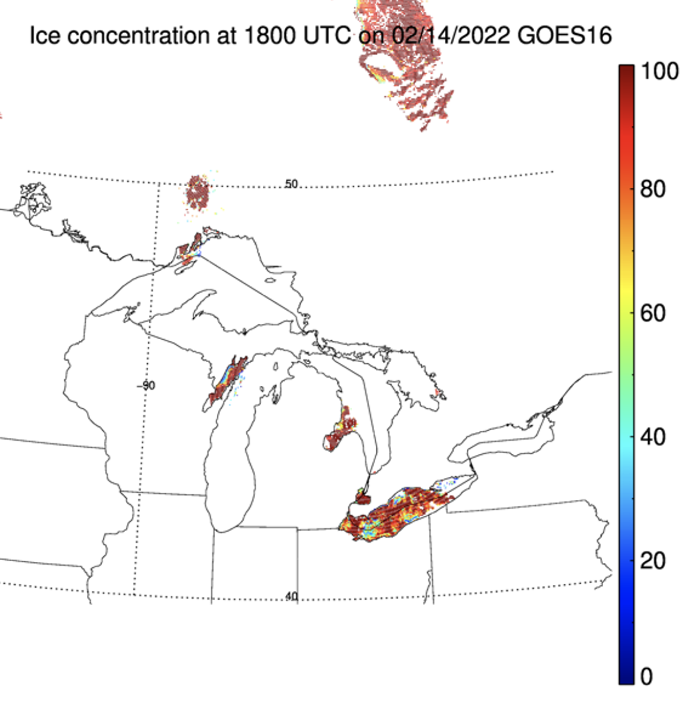
GOES-R Enterprise Ice Concentration Review: A GOES-R Enterprise Algorithm Review (GEAR) was held for the Advanced Baseline Imager (ABI) Enterprise Ice Concentration product on 26 May 2022. These reviews are held for each Enterprise (not Baseline) algorithm prior to implementation in the Operational Environment (OE). The reviews address the science code and processing differences, output parameter and quality flag differences, and algorithm performance specifications. Yinghui Liu (STAR) presented the Ice Concentration analysis. No significant problems where found, so the product will move forward to operations in the coming months. (J. Key, E/RA2, 608-263-2605, jeff.key@noaa.gov)
 (Click image to enlarge)
Figure: ABI ice concentration on 14 February 2022.
FUTURE OUTLOOK:
AWARDS AND RECOGNITION:
TRAVEL AND MEETINGS:
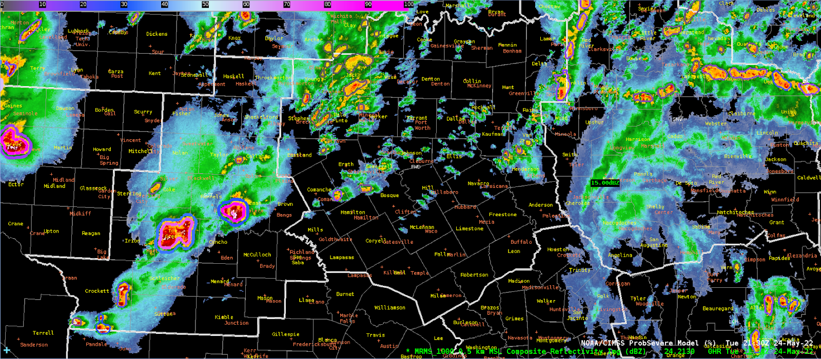
CIMSS Participation during Week 1 of the Hazardous Weather Testbed at SPC: John Cintineo, Justin Sieglaff and Scott Lindstrom, all from the Cooperative Institute for Meteorological Satellite Studies (CIMSS), participated in the Hazardous Weather Testbed (HWT) during the week of 23-27 May. HWT is a simulated forecasting exercise sponsored by the Storm Prediction Center (SPC) for NWS forecasters that is designed to showcase new products useful for decision support during times of severe weather. Forecasters can offer direct feedback to product developers, and product developers can directly guide forecasters on best practices for the new products' use. CIMSS-developed products being showcased at HWT include ProvSevere (version 3), ProbSevere LightningCast, and Polar Hyperspectral Soundings/ABI forecast (i.e. PHSnABI) model results. (S. Lindstrom, 608 263 4425; J. Cintineo, J. Sieglaff, CIMSS)
 (Click image to enlarge)
Figure: AWIPS display from a HWT Participant including ProbSevere over the San Angelo Forecast area, Late Tuesday 24 May 2022
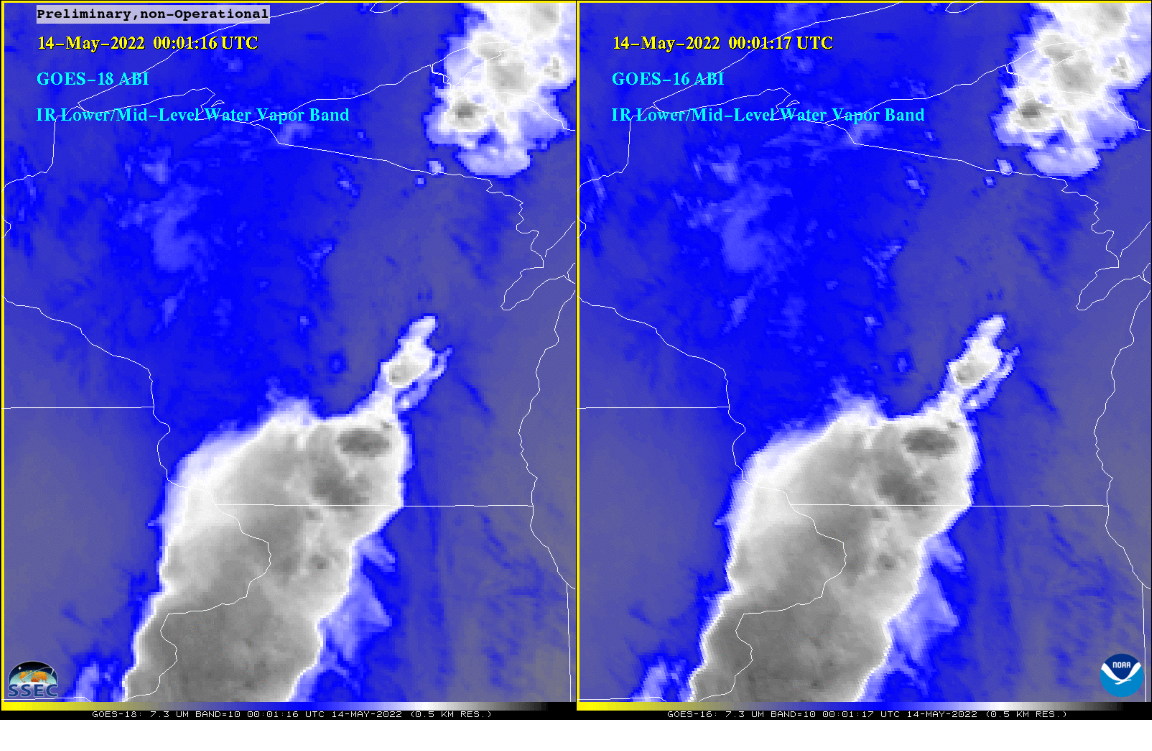
Briefing on Satellites to Local NWS Offices: On May 23, 2022, S. Lindstrom (CIMSS) and T. Schmit (ASPB) provided a virtual presentation to the NWS staff at the Milwaukee (NWS MKX), Chicago (NWS LOT) and LaCrosse (NWS ARX) weather forecast offices. Topics included: NOAA-Unique Combined Atmospheric Processing System (NUCAPS) profiles, GLM (Geostationary Lightning Mapper), ProbSevere (version 2 and version 3), LightningCast; RGB and Level 2 readouts in AWIPS; customizing colortables; GOES (Geostationary Operational Environmental Satellite)-18 ABI (Advanced Baseline Imager) status and comparisons; and the new Weighting Function web page at https://cimss.ssec.wisc.edu/goes-wf/ and how that information can be used to foster better interpretation of water vapor imagery. (S. Lindstrom, CIMSS, T. Schmit, E/RA2, 608-263-0291)
 (Click image to enlarge)
Figure: A band 10 (low-level water vapor) GOES-18 (preliminary, non-operational) ABI comparison to GOES-16 over Wisconsin on May 14, 2022 at 00 UTC. Images are shown in the same projection. Very good qualitative agreement is seen.
TRAINING AND EDUCATION:
MEDIA INTERACTIONS AND REQUESTS:
SOCIAL MEDIA AND BLOG Posts:
SSEC and CIMSS Scientists in the News: Scientists at the University of Wisconsin-Madison (UW) Space Science and Engineering Center (SSEC) and the Cooperative Institute for Meteorological Satellite Studies (CIMSS) provide expert interviews, imagery and case studies to promote science. This week: 1) Three products from SSEC/CIMSS/NOAA tested at this year's Hazardous Weather Testbed. SSEC News published this story: https://www.ssec.wisc.edu/news/articles/14513/. 2) CIMSS Satellite Blog contributors Alexa Ross, Scott Lindstrom and Scott Bachmeier published these case studies: "View and animate GOES-16 and GOES-17 Full-Disk IFR/Low IFR Probability fields in RealEarth" (May 25), "Severe thunderstorms in Texas" (May 24), "Severe thunderstorms in New Mexico and Texas" (May 23), "Tropical Invest 90L in the Gulf of Mexico" (May 22), "Severe thunderstorms in Michigan produce a fatal EF-3 tornado in Gaylord" (May 20), "ProbSevere (and NUCAPS) with the Gaylord Tornado" (May 20), "Long-lived MCV crossing the United States" (May 20) and "Bore features over Lake Michigan" (May 20). Read more at the CIMSS Satellite Blog: https://cimss.ssec.wisc.edu/satellite-blog/. (E. Verbeten, SSEC, S. Lindstrom, CIMSS, M. Pavolonis, E/RA2, A. Ross, SSEC, S. Bachmeier, CIMSS, J. Phillips, SSEC, 608-262-8164)
 (Click image to enlarge)
Figure: Three SSEC/CIMSS/NOAA products tested at the NOAA Hazardous Weather Testbed. Read more: https://www.ssec.wisc.edu/news/articles/14513/. Credit: SSEC, CIMSS, NOAA.
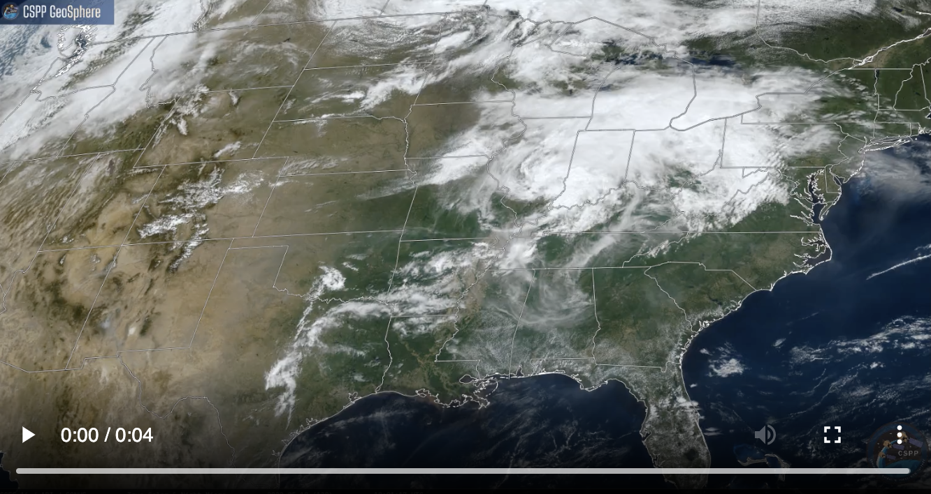 (Click image to enlarge)
Figure: Daytime and nighttime GOES-16 images processed with CSPP GeoSphere captured a mesoscale convective system over the High Plains late on May 18, 2022. It developed into a mesoscale convective vortex that persisted into May 20, 2022 over the mid-Atlantic States. Read more at the CIMSS Satellite Blog: https://cimss.ssec.wisc.edu/satellite-blog/archives/46439. Credit: CIMSS, CSPP GeoSphere, NOAA.
PUBLICATIONS:
OTHER:
| Archived Weeklies Page | Submit a report item |