[ Archive ]
| CIMSS-NOAA Weekly Report [ Archive ] |
CIMSS AND ASPB WEEKLY HIGHLIGHTS FOR THE WEEK ENDING JUNE 10, 2022
DATA, INFORMATION, AND USE-INSPIRED SCIENCE:
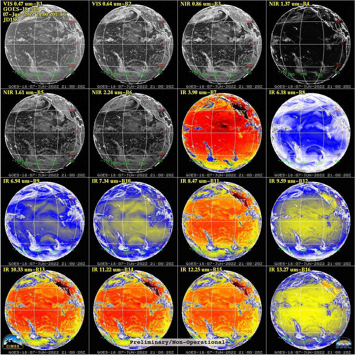
GOES-18 ABI PLT Resumes: The GOES-18 Advanced Baseline Imager (ABI) Post Launch Test (PLT) continued this week as GOES-18 reached the GOES-West location at 136.8 West longitude. Researchers at the Cooperative Institute for Meteorological Satellite Studies (CIMSS) and Space Science & Engineering Center (SSEC) resumed activities collecting ABI data and generating imagery on the web. NESDIS plans to release an Earth From Orbit video highlighting the first GOES-18 imagery from West and CIMSS researchers, in coordination with NOAA Center for Satellite Applications and Research (STAR) and Cooperative Institute for Research in the Atmosphere (CIRA) colleagues, provided multiple animations of interesting meteorological phenomena for the video. (M. Gunshor, CIMSS, 608-263-1146, T. Schmit, E/RA2, 608-263-0291, tim.j.schmit@noaa.gov, J. Nelson, CIMSS, S. Bachmeier, CIMSS)
 (Click image to enlarge)
Figure: 16 panel image showing all 16 bands of the GOES-18 ABI Full Disk sector at 2100 UTC (local satellite noon) on June 7, 2022. Preliminary, Non-Operational realtime images can be found at the CIMSS webpage: http://cimss.ssec.wisc.edu/goes-r/abi-/static_and_timediff_imagery.html.
FUTURE OUTLOOK:
AWARDS AND RECOGNITION:
TRAVEL AND MEETINGS:
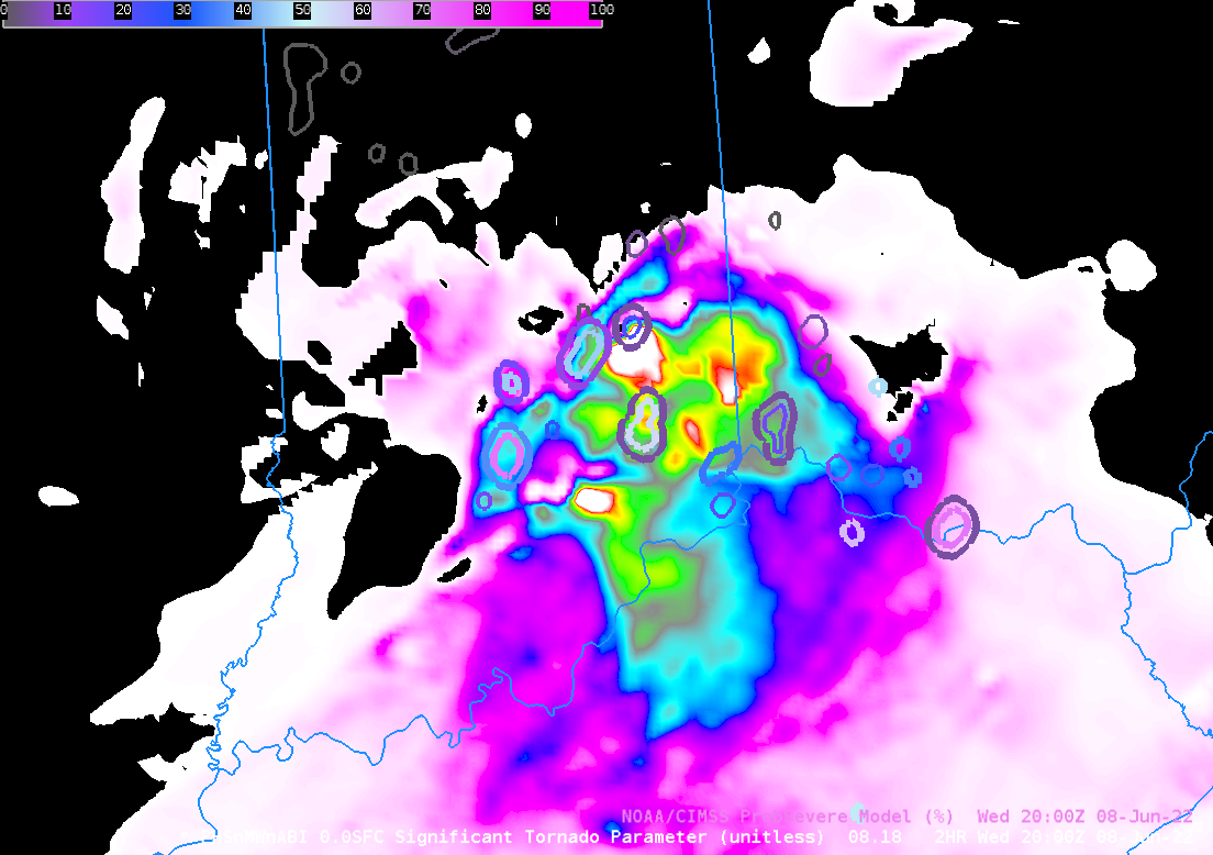
CIMSS Participation during Week 2 of the Hazardous Weather Testbed at SPC: John Cintineo, Justin Sieglaff and Scott Lindstrom, all from the Cooperative Institute for Meteorological Satellite Studies (CIMSS), participated in the Hazardous Weather Testbed (HWT) during the week of 6-10 June. HWT is a simulated forecasting exercise sponsored by the Storm Prediction Center (SPC) for NWS forecasters. HWT is designed to showcase new products useful for decision support during times of severe weather. Forecasters can offer direct feedback to product developers, and product developers can directly guide forecasters on best practices for the new products' use. In other words, there are discussions between developers and forecasters in real time that are simultaneously enlightening and entertaining. CIMSS-developed products being showcased at HWT include ProvSevere (version 3), ProbSevere LightningCast, and Polar Hyperspectral Soundings/ABI forecast (i.e. PHSnABI) model results. (S. Lindstrom, 608 263 4425; J. Cintineo, J. Sieglaff, CIMSS)
 (Click image to enlarge)
Figure: PHSnMWnABI model depiction of Significant Tornado Parameter (STP) at 2000 UTC (a 2-h forecast) on 8 June 2022, overlain with ProbSevere (v3) shapefiles at the same time.
TRAINING AND EDUCATION:
Summer Interns at CIMSS: A group of undergraduate computer science students have begun summer internships at the Cooperative Institute for Meteorological Satellite Studies (CIMSS). NOAA projects they will be working on include the GOES-R Algorithm Working Group (AWG) Imagery and Fire Detection Teams. Other interns will be working on related remote-sensing projects funded by NASA. Their work will include Python programming, web page design, machine learning, and high speed imagery generation. (M. Gunshor, CIMSS, 608-263-1146, C. Schmidt, CIMSS).
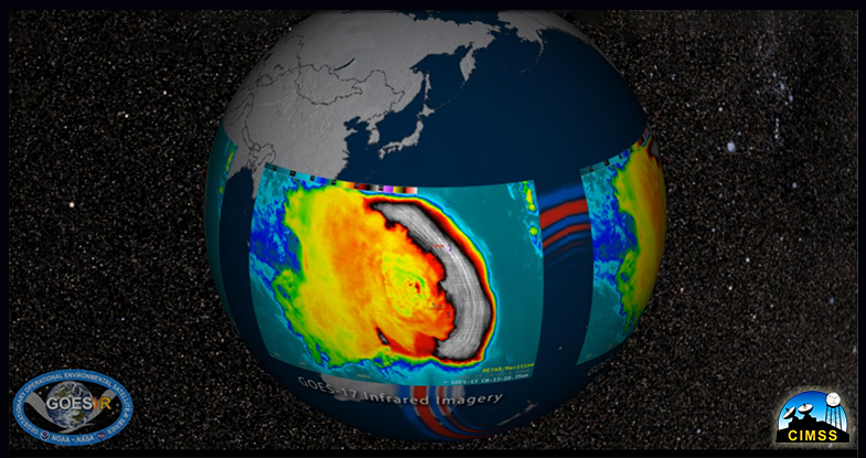
New Hunga Tonga video for NOAA Science On a Sphere: A new educational video on the Hunga Tonga-Hunga Ha’apai Volcano Eruption was released for NOAA Science On Sphere (SOS) this week, providing a succinct update summarizing insights on the explosive and historic event. The movie features satellite data from NOAA's Geostationary Operational Environmental Satellites (GOES) 17 and 16, Europe's Meteosat-Prime and IODC, and Japan's Himawari-8 satellite. The final product was a collaborative effort between NOAA’s Cooperative Institute for Meteorological Satellite Studies (CIMSS), the Space Science and Engineering Center (SSEC), and NOAA’s Advanced Satellite Product Branch (ASPB) with support from NOAA's GOES-R program. A YouTube version of the dataset can be viewed at https://sphere.ssec.wisc.edu/hunga-tonga2022/. (M. Mooney, CIMSS, R. Kohrs, SSEC, M. Gunshor, CIMSS, T. Schmit, NOAA)
 (Click image to enlarge)
MEDIA INTERACTIONS AND REQUESTS:
SOCIAL MEDIA AND BLOG Posts:
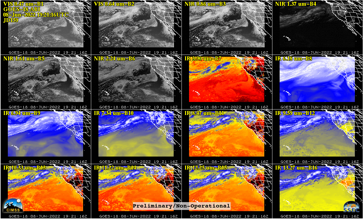
SSEC and CIMSS Scientists in the News: Scientists at the University of Wisconsin-Madison (UW) Space Science and Engineering Center (SSEC) and the Cooperative Institute for Meteorological Satellite Studies (CIMSS) provide expert interviews, imagery and case studies to promote science. This week: 1) NOAA Scientist Tim Schmit supports the case for hyperspectral sounders on future geostationary satellites in "Why NOAA Wants Its Sounders," published by Aerospace America. Read more: https://aerospaceamerica.aiaa.org/features/why-noaa-wants-its-sounders/. 2) CIMSS Satellite Blog contributors Tim Schmit, Scott Bachmeier, Alexa Ross and Scott Lindstrom published these case studies: "GOES-18 (Prelim/Non-Op) ABI 16-panels" (June 8), "GOES-18 imagery resumes, from its position over the Pacific Ocean" (June 7), "GOES-17 IFR, Low IFR, and MVFR Probability fields over South Alaska" June 7", "Bore feature in SAR winds over Lake Michigan" (June 6), "Tropical Storm Alex" (June 5), "Comparing IFR Probability with NDBC BuoyCam imagery" (June 2). Read more at the CIMSS Satellite Blog: https://cimss.ssec.wisc.edu/satellite-blog/. (T. Schmit, E/RA2, S. Bachmeier, CIMSS, A. Ross, SSEC, S. Lindstrom, CIMSS, J. Phillips, 608-262-8164)
 (Click image to enlarge)
Figure: Sixteen panels from the GOES-18 Advanced Baseline Imager over the Pacific US sector. Images are considered preliminary, non-operational. Read more at the CIMSS Satellite Blog: https://cimss.ssec.wisc.edu/satellite-blog/archives/46698. Credit: CIMSS, NOAA.
 (Click image to enlarge)
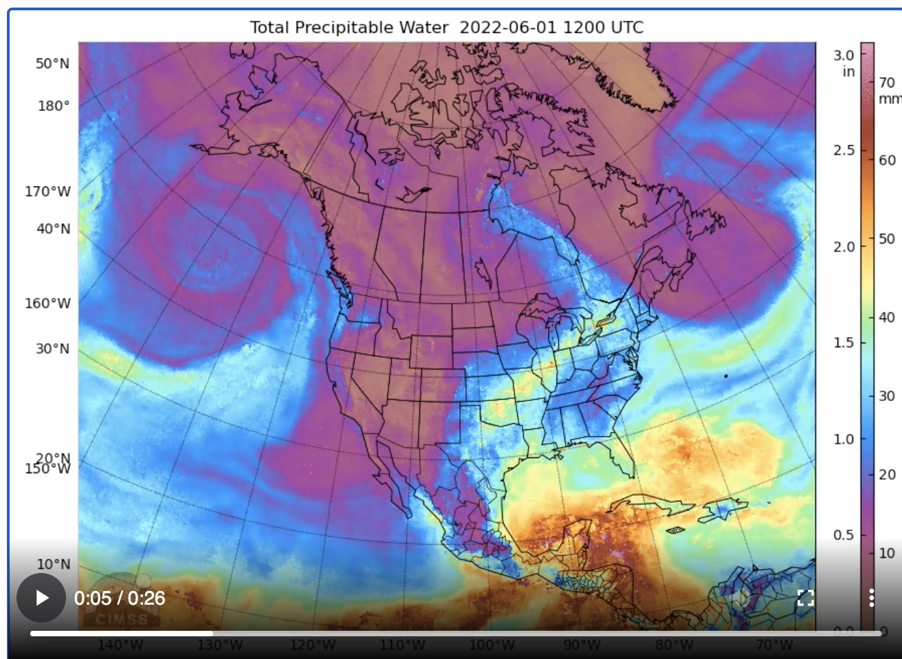
Figure: A Morphed Integrated Microwave Imagery at CIMSS - Total Precipitable Water (MIMIC-TPW) animation showing Pacific Hurricane Agatha, its landfall, and the resulting moisture incorporated into Tropical Storm Alex, May 28 - June 7, 2022. Read more at the CIMSS Satellite Blog: https://cimss.ssec.wisc.edu/satellite-blog/archives/46713. Credit: CIMSS.
PUBLICATIONS:
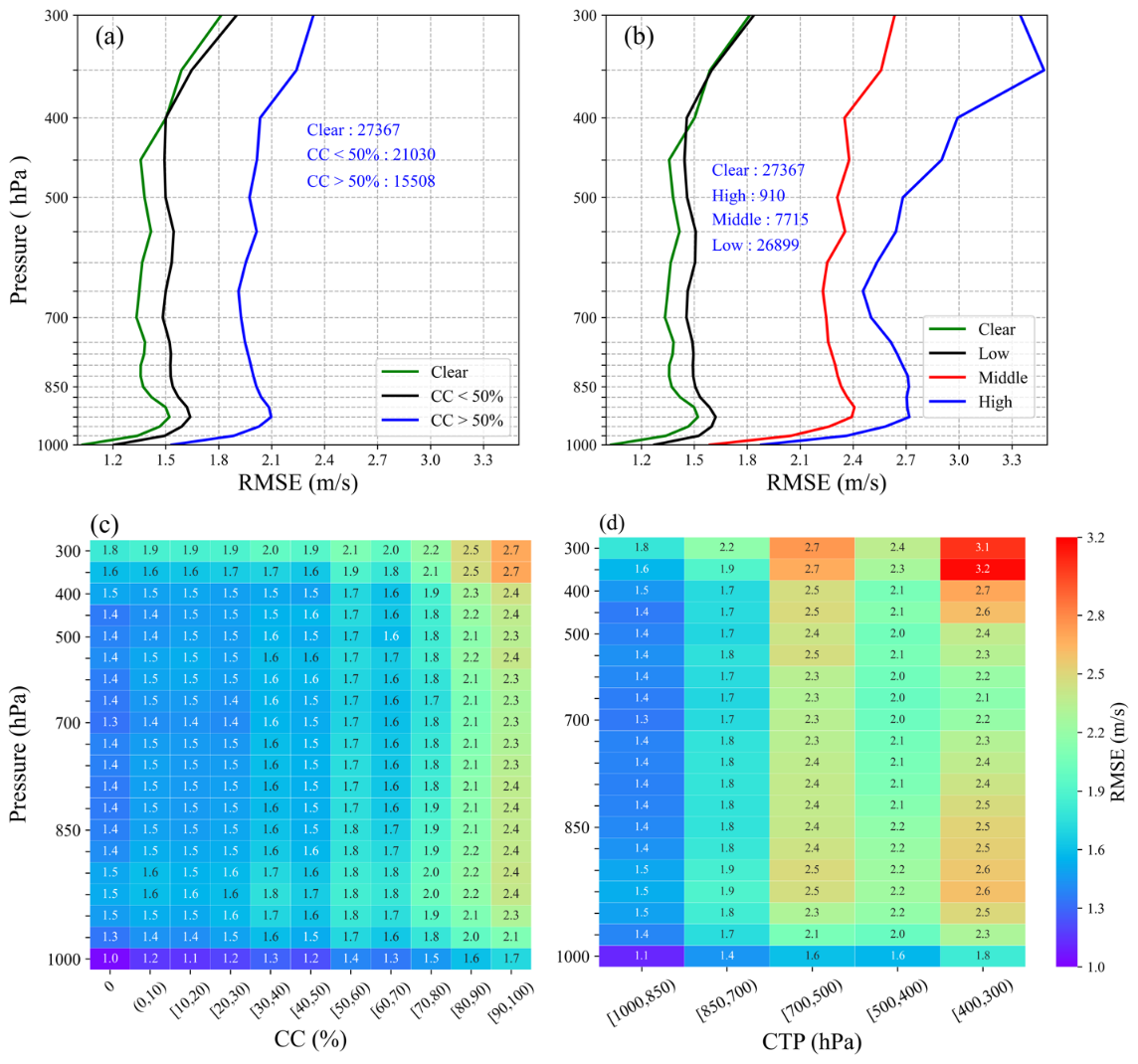
3D Winds Paper published in GRL: Using the collocated high spatial, spectral, and temporal resolution cloud information from Advanced Geostationary Radiation Imager (AGRI) and Geostationary Interferometric Infrared Sounder (GIIRS) onboard the same experimental geostationary satellite FengYun-4A, 3D horizontal wind fields are derived under both clear and partially cloudy skies. It is found that sub-footprint cloudiness has a substantial influence on wind retrievals that needs to be considered in quantitative applications. Higher/lower and thicker/thinner clouds have more/less influence on the 3D horizontal wind product. Placing a high spatial resolution imager and a hyperspectral infrared sounder on the same geostationary platform enables quantifying the sounder sub-footprint cloudiness better and thus improves retrieval and application of the 3D winds. Citation: Li, J., Zhang, Y., Di, D., Ma, Z., Li, Z., Schmit, T. J., & Menzel, W. P. (2022), The influence of sub-footprint cloudiness on three-dimensional horizontal wind from geostationary hyperspectral infrared sounder observations, Geophysical Research Letters, 49, e2022GL098460, https://doi.org/10.1029/2022GL098460. (W.P. Menzel, CIMSS, 608-263-4930)
 (Click image to enlarge)
Figure: Left: RMSE of wind (U and V together) under clear skies, thin cloud cover (CC<50%) and thick cloud cover (CC>50%) for all CTP situations. Right: RMSE of wind (U and V together) under clear skies, low, middle, and high clouds for all CC situations.
OTHER:
| Archived Weeklies Page | Submit a report item |