[ Archive ]
| CIMSS-NOAA Weekly Report [ Archive ] |
CIMSS AND ASPB WEEKLY HIGHLIGHTS FOR THE WEEK ENDING JUNE 24, 2022
DATA, INFORMATION, AND USE-INSPIRED SCIENCE:
FUTURE OUTLOOK:
AWARDS AND RECOGNITION:
TRAVEL AND MEETINGS:
GOES-16/-17 Fires at AMS Broadcast Meteorology Conference: Chris Schmidt of the Cooperative Institute for Meteorological Satellite Studies (CIMSS) discussed the use and interpretation of the Geostationary Operational Environmental Satellite (GOES) Advanced Baseline Imager (ABI) Fire Detection and Characterization Algorithm (FDCA) product at the American Meteorological Society (AMS)’s 49th Conference on Broadcast Meteorology/Sixth Conference on Weather Warnings and Communication. The Conference on Broadcast Meteorology provides a unique opportunity to bring awareness of GOES products and capabilities to the set of users most directly connected to the public, users who are generally restricted to the products that commercial vendors make available to them and what they can find online. “On Using GOES to Monitor Wildfires” discussed the basic capabilities of the ABI with respect to monitoring fires as well as the Fire Detection and Characterization Algorithm product. These users have a great deal of interest in fire data and visualizations but have no direct access to the fire products and limited access to the raw ABI data that best shows fires, so feedback was collected as to what they would like to have available to present to the public. That feedback will inform the new fire efforts at CIMSS and NOAA. The animations from the presentation can be found at https://go.wisc.edu/4m0u61. (C. Schmidt, CIMSS, 608-262-7973)
TRAINING AND EDUCATION:
MEDIA INTERACTIONS AND REQUESTS:
SOCIAL MEDIA AND BLOG Posts:
SSEC and CIMSS Scientists in the News: Scientists at the University of Wisconsin-Madison (UW) Space Science and Engineering Center (SSEC) and the Cooperative Institute for Meteorological Satellite Studies (CIMSS) provide expert interviews, imagery and case studies to promote science. This week: 1) SSEC News published, "Flash drought — A multivariable approach to understanding drought impacts," highlighting CIMSS scientist Jason Otkin's continuing research, recently funded by the NOAA Climate Program Office. Read more: https://www.ssec.wisc.edu/news/articles/14559/. 2) CIMSS Satellite Blog contributors Scott Bachmeier, Scott Lindstrom, Alexa Ross and Tim Schmit published these case studies: "Alaskan wildfire smoke" (June 22), "Cross-sections using gridded NUCAPS data in AWIPS" (June 21), "VIIRS composite flood products over Bangladesh and India" (June 21), "Can Geostationary Imagers See Noctilucent Clouds?" (June 20), and "30-second GOES-18 images of the SpaceX SARah-1 launch" (June 18). Read more at the CIMSS Satellite Blog: https://cimss.ssec.wisc.edu/satellite-blog/. (J. Otkin, CIMSS, E. Verbeten, SSEC, S. Bachmeier, CIMSS, S. Lindstrom, CIMSS, A. Ross, SSEC, T. Schmit, E/RA2, J. Phillips, 608-262-8164)
 (Click image to enlarge)
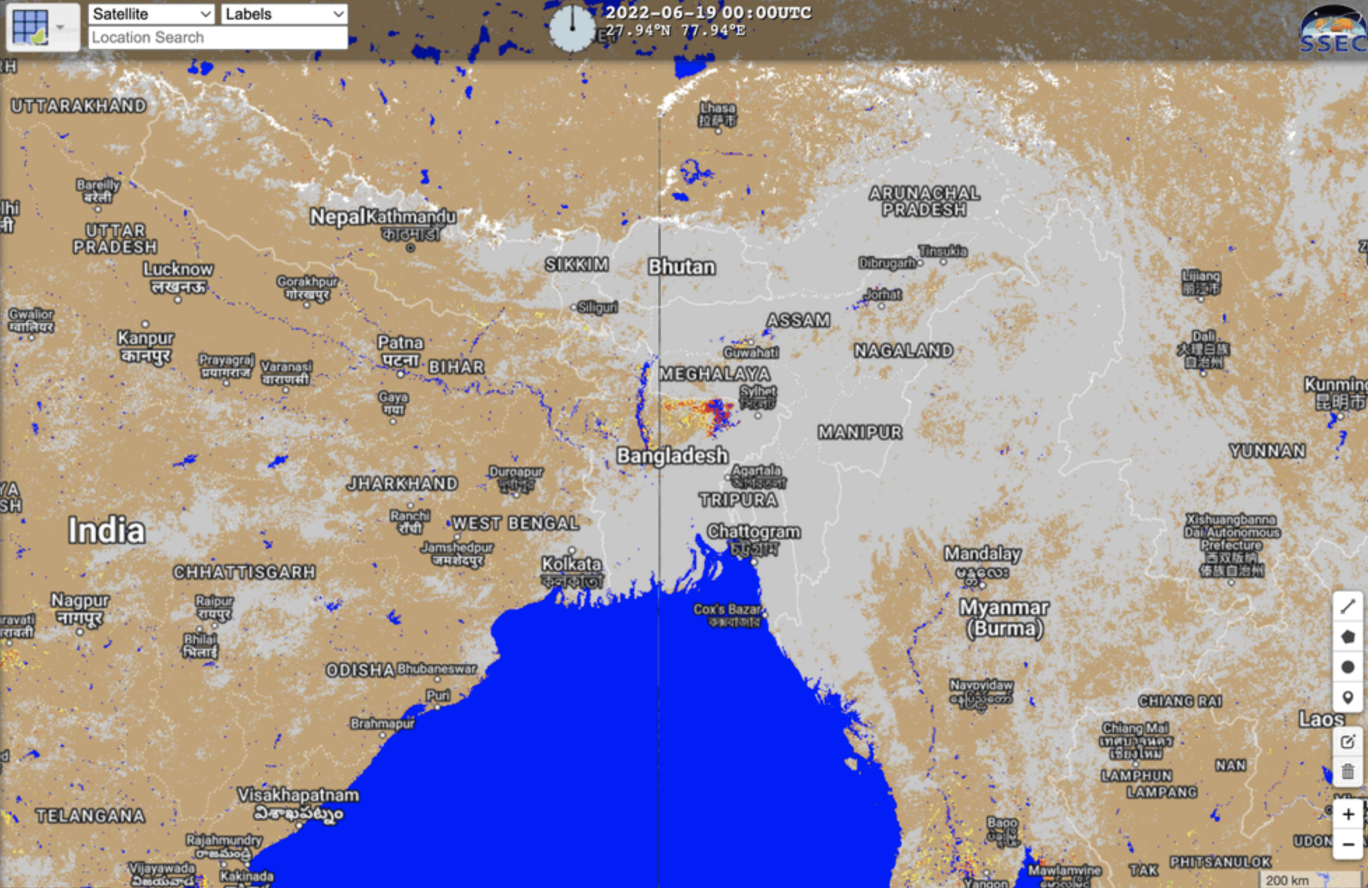
Figure: The Visible Infrared Imaging Radiometer Suite (VIIRS) five-day flood product composite highlighted flooding in Bangladesh and northwest India, June 15-22, 2022. Read more at the CIMSS Satellite Blog: https://cimss.ssec.wisc.edu/satellite-blog/archives/46919. Credit: CIMSS, George Mason University, SSEC RealEarth, NOAA.
 (Click image to enlarge)
Figure: GOES-18 images captured smoke from Alaskan wildfires as it was transported over Kodiak Island and the northern Gulf of Alaska on June 22, 2022. Read more at the CIMSS Satellite Blog: https://cimss.ssec.wisc.edu/satellite-blog/archives/46963. Credit: CIMSS, Geo2Grid, NOAA.
PUBLICATIONS:
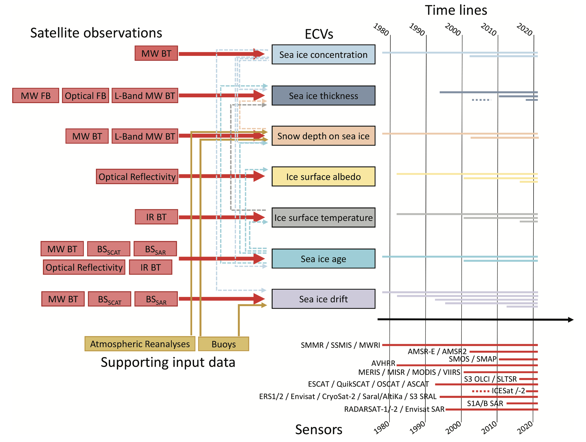
Manuscript Published on Sea Ice Essential Climate Variables: The Global Climate Observing System (GCOS), a body of the World Meteorological Organization (WMO), assesses the maturity of the global observing system and gives guidance for its development. The Essential Climate Variables (ECVs) are central to GCOS. Currently, a single sea ice ECV encapsulates all aspects of the sea ice environment. A paper was just published in the Bulletin of the American Meteorological Society (BAMS), which argues that GCOS should consider a set of seven ECVs for sea ice: concentration, thickness, snow depth, surface temperature, surface albedo, age, and drift. These seven ECVs are critical and cost effective to monitor with existing satellite Earth observation capability. J. Key (STAR) was a co-author. Citation: Lavergne, T., S. Kern, and others, 2022, A New Structure for the Sea Ice Essential Climate Variables of the Global Climate Observing System, Bull. Amer. Meteor. Soc., E1502-E1521, https://doi.org/10.1175/BAMS-D-21-0227.1. (J. Key, E/RA2, 608-263-2605, jeff.key@noaa.gov)
 (Click image to enlarge)
Figure: Overview of the seven ECVs and their potential temporal coverage based on available satellite observations. See Lavergne et al. (https://doi.org/10.1175/BAMS-D-21-0227.1) for details.
Paper Published in Atmospheric Chemistry and Physics: Scott Lindstrom from the Cooperative Institute for Meteorological Satellites Studies (CIMSS) is second author on a paper published on 21 June 2022 in Atmospheric Chemistry and Physics (https://acp.copernicus.org/articles/22/7995/2022/; https://doi.org/10.5194/acp-22-7995-2022). The paper, titled "The formation and composition of the Mount Everest plume in winter" (lead author: Edward E Hindman, retired from the City College of New York), uses MODIS imagery, GOES-9 imagery, and Himawari-8 imagery to investigate plumes that form down wind of Mt Everest in clear skies. MODIS imagery was created using Polar2Grid, and Himawari-8 imagery was created using Geo2Grid, two software display packages developed and maintained at CIMSS. (S. Lindstrom, CIMSS,608 263 4425)
Paper on Sensor Impact on Arctic Cloud Radiative Forcing Published: A paper titled, "Impacts of Active Satellite Sensors’ Low-level Cloud Detection Limitations on Cloud Radiative Forcing in the Arctic", was published in Atmospheric Chemistry and Physics. This study uses radiative transfer models to investigate the limitations in low-level cloud detection by the space-based active sensors, and the impact of these limitations on the radiation fluxes at the surface and the top of the atmosphere (TOA). The results show cloud detection limitations from combined sensors lead to uncertainties in the monthly mean cloud radiative forcing (CRF), with maximum absolute monthly mean values of 2.5 Wm-2 and 3.4 Wm-2 at the surface and TOA, respectively. Cloud from individual sensor leads to larger cloud detection uncertainties and larger CRF uncertainties with absolute monthly means larger than 10.0 Wm-2 at the surface and TOA. The uncertainties for individual cases are larger – up to 30 Wm-2. This study suggests these uncertainties need to be considered when radiation flux products from space-based sensors are used in climate and weather studies. Citation: Liu, Y.: Impacts of active satellite sensors' low-level cloud detection limitations on cloud radiative forcing in the Arctic, Atmos. Chem. Phys., 22, 8151–8173, https://doi.org/10.5194/acp-22-8151-2022, 2022.
![]() (Click image to enlarge)
(Click image to enlarge)
Figure: (a) CRF with a 20 d running average of daily means at the surface for longwave (LW) and shortwave (SW) with clouds from surface observations collected during the SHEBA experiment and (b) CRF differences with clouds identified by the combined CloudSat and CALIPSO (CC) and all clouds from surface observations.
OTHER:
| Archived Weeklies Page | Submit a report item |