[ Archive ]
| CIMSS-NOAA Weekly Report [ Archive ] |
CIMSS AND ASPB WEEKLY HIGHLIGHTS FOR THE WEEK ENDING JULY 15, 2022
DATA, INFORMATION, AND USE-INSPIRED SCIENCE:
Assistance provided to Joint Typhoon Warning Center on Super Typhoon Rai: In response to a special request from the Joint Typhoon Warning Center (JTWC) in Hawai`i, Derrick Herndon and Scott Bachmeier of the Cooperative Institute for Meteorological Satellite Studies (CIMSS) provided high-resolution Atmospheric Motion Vectors (AMVs) and Himawari-8 Infrared and Water Vapor imagery of Super Typhoon RAI, which moved toward the Philippines in December 2021. JTWC was using this additional information to complete their detailed storm review. (D. Herndon, CIMSS, S. Bachmeier, CIMSS)
FUTURE OUTLOOK:
AWARDS AND RECOGNITION:
TRAVEL AND MEETINGS:
TRAINING AND EDUCATION:
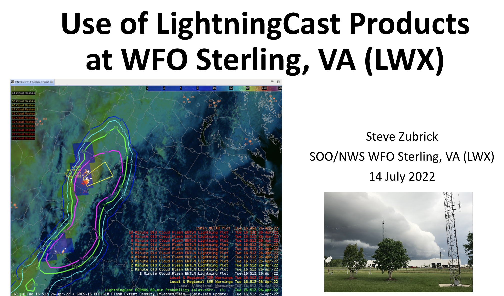
Panel discussion on ProbSevere LightningCast at the GOES-R Satellite Book Club Seminar Series: John Cintineo of the Cooperative Institute for Meteorological Satellite Studies (CIMSS) participated in a panel discussion regarding National Weather Service (NWS) feedback of the ProbSevere LightningCast model during the GOES-R Satellite Book Club seminar on July 14, 2022. LightningCast is an experimental model that uses GOES-R Advanced Baseline Imager (ABI) images to predict the probability of lightning in the next hour at any given location. NWS forecasters from the Dallas-Fort Worth and Baltimore-Washington D.C. offices were also panelists, and discussed how LightningCast has helped their offices during operations. (J. Cintineo, CIMSS, cintineo@wisc.edu; M. Pavolonis, E/RA2, 608-263-9597, michael.pavolonis@noaa.gov; Justin Sieglaff, CIMSS, justin.sieglaff@ssec.wisc.edu; Lee Cronce, CIMSS, lee.cronce@ssec.wisc.edu).
 (Click image to enlarge)
Figure: Title slide for Steve Zubrick's (NWS Baltimore/Washington D.C.) presentation regarding his office's use of LightningCast output.
MEDIA INTERACTIONS AND REQUESTS:
SOCIAL MEDIA AND BLOG Posts:
SSEC and CIMSS Scientists in the News: Scientists at the University of Wisconsin-Madison (UW) Space Science and Engineering Center (SSEC) and the Cooperative Institute for Meteorological Satellite Studies (CIMSS) provide expert interviews, imagery and case studies to promote science. This week: 1) CIMSS hurricane researcher Derrick Herndon did a one-hour, live interview that was broadcast during the National Topical Weather Conference on Wednesday, July 13, 2022. 2) CIMSS Satellite Blog contributors Scott Lindstrom and Scott Bachmeier published these case studies: "Himawari-8 and NUCAPS observations of an upper-level feature in the western Pacific" (July 13), "Pyrocumulonimbus cloud in northwestern Canada" (July 12), "Dry (and dusty) air over the Caribbean" (July 12), "Hurricane Darby in the East Pacific Ocean" (July 11), "SAR Winds over the tropical Pacific Ocean" (July 11), "30-second imagery of severe thunderstorms across Montana" (July 9) and "NUCAPS Cross Sections over the south Pacific" (July 8). Read more at the CIMSS Satellite Blog: https://cimss.ssec.wisc.edu/satellite-blog/. (D. Herndon, CIMSS, S. Lindstrom, CIMSS, S. Bachmeier, CIMSS, J. Phillips, SSEC, 608-262-8164)
 (Click image to enlarge)
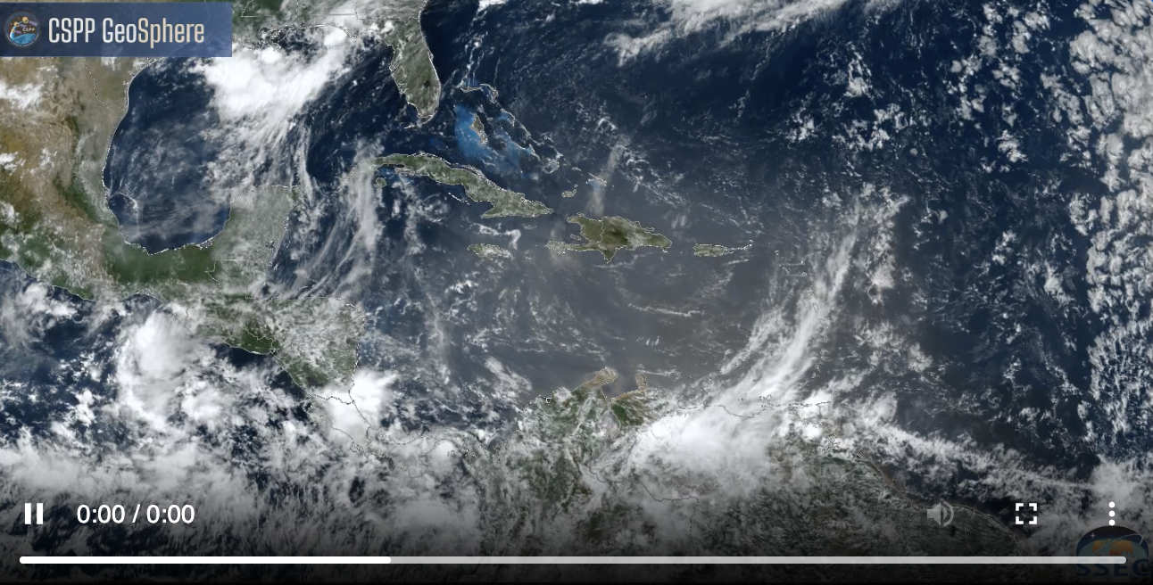
Figure: GOES-16 imagery visualized on the CSPP GeoSphere website suggests dust over the eastern Caribbean Sea on July 12, 2022 that persists even as the region of sun glint fades. Suspended dust in the tropical Atlantic is known to suppress convection. Read more at the CIMSS Satellite Blog: https://cimss.ssec.wisc.edu/satellite-blog/archives/47176. Credit: CIMSS, CSPP GeoSphere and Geo2Grid, NOAA.
 (Click image to enlarge)
Figure: GOES-17 images captured the evolution of Hurricane Darby's eye as it traveled westward across the East Pacific Ocean on July 11, 2022. Read more at the CIMSS Satellite Blog: https://cimss.ssec.wisc.edu/satellite-blog/archives/47155. Credit: CIMSS, NOAA.
PUBLICATIONS:
OTHER:
| Archived Weeklies Page | Submit a report item |