[ Archive ]
| CIMSS-NOAA Weekly Report [ Archive ] |
CIMSS AND ASPB WEEKLY HIGHLIGHTS FOR THE WEEK ENDING JULY 22, 2022
DATA, INFORMATION, AND USE-INSPIRED SCIENCE:
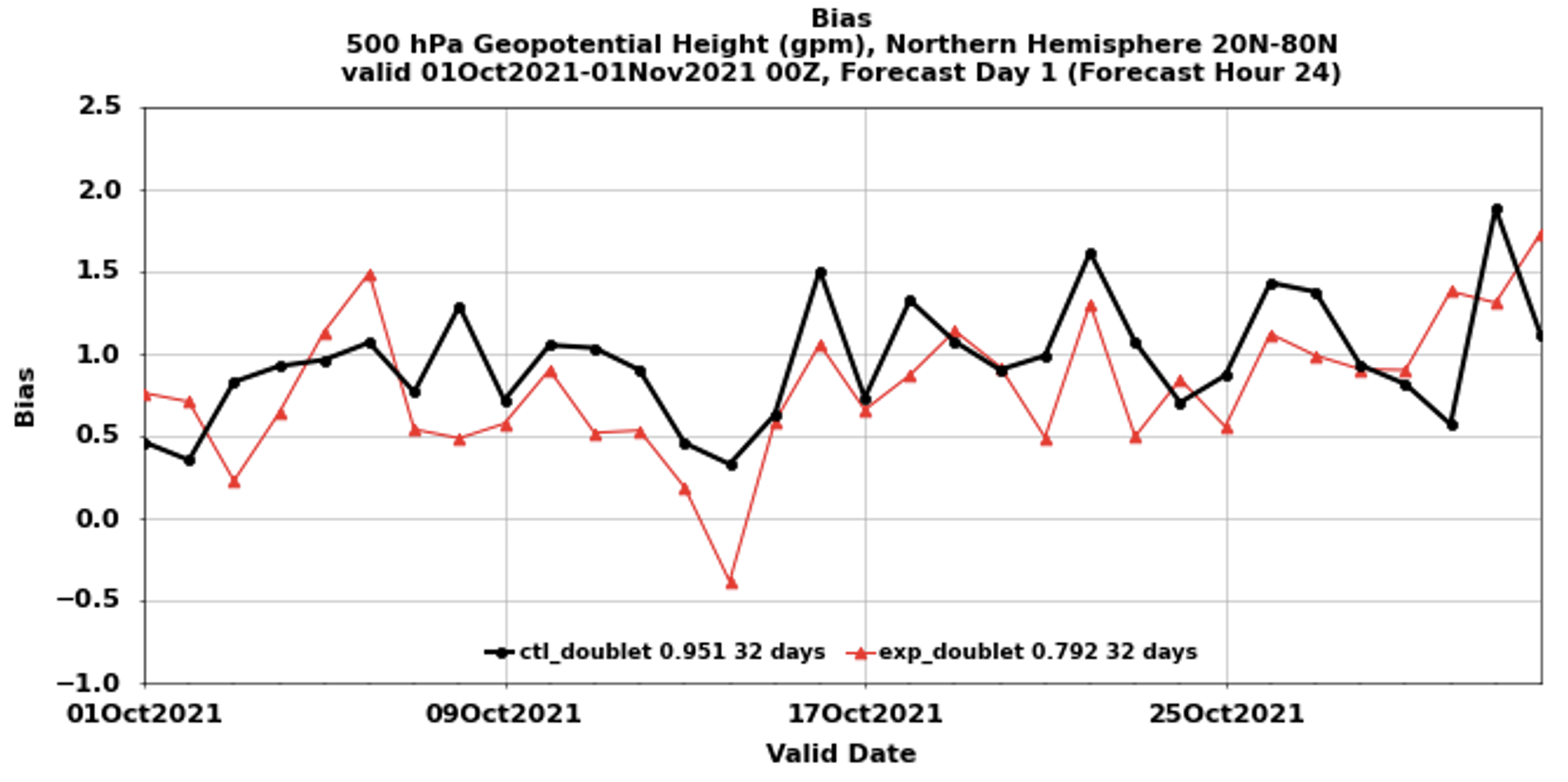
VIIRS Tandem Winds Assimilation and Forecast Impact: An experimental product was developed by the NOAA/CIMSS (Cooperative Institute for Meteorological Satellite Studies) polar winds team that uses a doublet (pair) of images from two satellites for deriving wind information rather than the traditional triplet of successive images/orbits from a single satellite. The product is termed ‘tandem winds’ as it uses orbits of Visible Infrared Imaging Radiometer Suite (VIIRS) images from two alternating satellites that are flying in tandemand separated by ½ orbit: Suomi-NPP and NOAA-20. The result is significant overlap in the two VIIRS swaths, allowing for daily global coverage of satellite winds from polar satellites. A six-week time period was selected to derive the winds and assimilate into the Global Data Assimilation System/Global Forecast System (GDAS/GFS) to quantify the impact on the model analysis and forecast. Using the current version of the GDAS/GFS on the S4 supercomputer at CIMSS, a control and an experiment were run, where the experiment includes the doublet winds. There was a significant improvement the Northern Hemisphere geopotential height bias throughout the troposphere at the 24-hr forecast. The figure below shows, for example, that at the 500 hPa level the red curve (experiment) is generally nearer the 0.0 bias line compared to the control (black). The reduction of the bias from 0.95 (control) to 0.79 (experiment) is statistically significant at the 95% level. (D. Santek, CIMSS, 608-263-7410, R. Dworak, CIMSS, T. Olander, CIMSS, D. Stettner, CIMSS, S. Nebuda, CIMSS, J. Key, E/RA2, 608-263-2605, jeff.key@noaa.gov)
 (Click image to enlarge)
Figure: The 24-hour forecast of GFS 500 hPa geopotential height bias over the Northern Hemisphere from 01 October to 01 November 2021. Control (black), experiment (red).
CSPP Geo Software Package Released to Support GOES-18 Processing: A new version of the Community Satellite Processing Package for Geostationary Data (CSPP Geo) AIT Framework software package was released, adding preliminary support for GOES-18 processing. The software allows direct broadcast users to process data from the Advanced Baseline Imager (ABI) on GOES-R series satellites, generating Level 2 geophysical products in near real-time. The update will allow direct broadcast users who are currently processing the GOES-West data stream to continue generating products after August 1, when GOES-17 ABI data will be replaced by GOES-18 ABI in the GOES-West data stream during periods of quality degradation in GOES-17 ABI. Also included in this release are science updates, as well as bug fixes and other improvements resulting from community feedback. The package was developed at the Cooperative Institute for Meteorological Satellite Studies (CIMSS), and incorporates product algorithms developed by the GOES-R Algorithm Working Group and a core processing system developed by the ASSISTT group at NOAA NESDIS. (G. Martin, CIMSS)
FUTURE OUTLOOK:
Fire Program Takes First Steps: Following a productive Spring Planning Meeting discussion, the NESDIS Executive Council approved the formation of a NESDIS Fire Program, led by Mike Pavolonis (NESDIS/STAR). The next step is to develop and brief a Terms of Reference at the next Executive Council meeting on September 14. In the meantime, Pavolonis and others have been focused on obligating funds for fire projects from the FY22 Disaster Relief Supplemental Act (DRSA) and Infrastructure Investment & Jobs Act (IIJA) via grants and contracts ahead of deadlines. NESDIS also briefed the U.S. Group on Observations (USGEO) Subcommittee on the NOAA response to a recent wildland fire observation gap assessment. For more details on what's happening in wildfire, see our June-July fire program updates (https://docs.google.com/document/d/1xWb-Vtr_alQ-1nfYL4yef2Af5N0IKSxsIYLIunW3KA0/edit?usp=sharing). (M. Pavolonis, E/RA2, 608-263-9597, Mike.Pavolonis@noaa.gov, R. Lana, NESDIS/OSAAP)
AWARDS AND RECOGNITION:
TRAVEL AND MEETINGS:
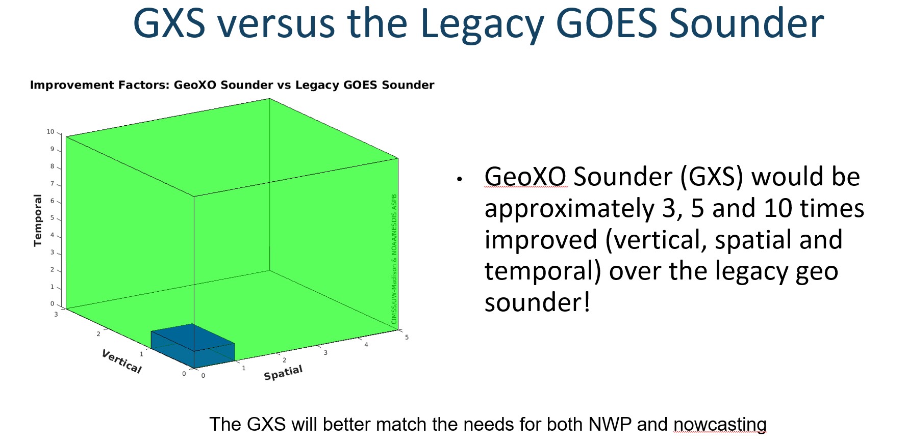
SSEC/CIMSS and ASPB Participation in IGARSS 2022: Several talks (some invited) by Space Science and Engineering Center (SSEC), Cooperative Institute for Meteorological Satellite Studies (CIMSS), and NESDIS/STAR Advanced Satellite Products Branch (ASPB) personnel were given virtually at the 2022 International Geoscience and Remote Sensing Symposium (IGARSS) which was held in Kuala Lumpur, Malaysia. The titles of the presentations are: “Next Generation Earth Satellite Measurement Opportunities – Lessons Learned From Current Satellite Research Applications”, “JPSS imagery and microwave capabilities as a vital cog in Typhoon forecasting”, "Satellite Fire Products: More Valuable Now Than Ever With Longer Fire Seasons", "The Big Picture: New IR Science Drivers, Key Observing Physics, and Proven Building Blocks Should Define The Next Generation Us Sounding System", "Critical Characteristics Of Future Leo Infrared Sounders" and "U.S. Plans For Geostationary Hyperspectral Infrared Sounders". The sessions were recorded. Details can be found in the technical program at https://igarss2022.org/technical_program.php. (T. Schmit, E/RA2, 608-263-0291, tim.j.schmit@noaa.gov; S. Lindstrom, W. Straka, CIMSS; 608 263 4425)
 (Click image to enlarge)
Figure: The information content between the legacy Geostationary Operational Environmental Satellite (GOES) sounder and that planned from the sounder on the Geostationary Extended Observations (GeoXO) constellation.
TRAINING AND EDUCATION:
Satellite Data Talk at ESIP Teacher Workshop: On July 21, 2022 Margaret Mooney from NOAA’s Cooperative Institute for Meteorological Satellite Studies (CIMSS) presented on Satellite Data and Satellite Virtual Science Fairs for 30 educators participating in the annual Earth Science Information Partners (ESIP) Teacher Workshop. Science Fair details are online at https://cimss.ssec.wisc.edu/education/sciencefairs.html. (M. Mooney, CIMSS, margaret.mooney@ssec.wisc.edu)
MEDIA INTERACTIONS AND REQUESTS:
SOCIAL MEDIA AND BLOG Posts:
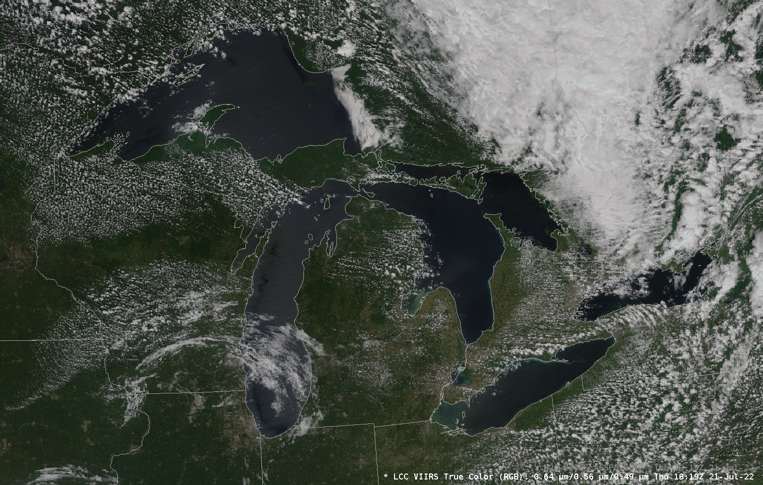
SSEC and CIMSS Scientists in the News: Scientists at the University of Wisconsin-Madison (UW) Space Science and Engineering Center (SSEC) and the Cooperative Institute for Meteorological Satellite Studies (CIMSS) provide expert interviews, imagery and case studies to promote science. This week: 1) CIMSS scientist Jason Otkin and SSEC Director Brad Pierce were interviewed for a NASA press release on Great Lakes air quality including their research aimed at estimating meteorological conditions that influence ozone concentrations in the region. Read more: https://www.nasa.gov/feature/great-air-quality-for-the-great-lakes-region. 2) CIMSS scientist Derrick Herndon joined Weather Geeks host Marshall Shepherd to discuss the Dvorak technique and latest improvements. Listen to the podcast: https://twitter.com/WeatherGeeks/status/1549709433726541827. 3) CIMSS Satellite Blog contributors Scott Lindstrom, Alexa Ross and Scott Bachmeier published these case studies: "Clear skies over the Great Lakes" (July 21), "SAR Winds over Tropical Cyclone Estelle in the Eastern Pacific" (July 20), "Anomalously-deep upper low brings light snow to northwestern Alaska" (July 19), "Pyrocumulonimbus clouds in Manitoba" (July 19), "Testing an interpolation technique for building a continuous GOES-17 data series" (July 19), "ACSPO SSTs over Lake Michigan and over the Pacific Ocean" (July 18), and "Mesoscale Convective Vortex over southern Nevada" (July 17). Read more at the CIMSS Satellite Blog: https://cimss.ssec.wisc.edu/satellite-blog/. (J. Otkin, CIMSS, B. Pierce, SSEC, D. Herndon, CIMSS, S. Lindstrom, CIMSS, A. Ross, SSEC, S. Bachmeier, CIMSS, J. Phillips, SSEC, 608-262-8164)
 (Click image to enlarge)
Figure: Mostly clear skies over the Great Lakes as seen from NOAA-20 on July 20, 2022. Clear conditions allowed for production of sea surface temperatures from the Advanced Clear-Sky Processor for Oceans (ACSPO) System. Read more at the CIMSS Satellite Blog: https://cimss.ssec.wisc.edu/satellite-blog/archives/47297. Credit: CIMSS, NOAA.
PUBLICATIONS:
OTHER:
| Archived Weeklies Page | Submit a report item |