[ Archive ]
| CIMSS-NOAA Weekly Report [ Archive ] |
CIMSS AND ASPB WEEKLY HIGHLIGHTS FOR THE WEEK ENDING JULY 29, 2022
DATA, INFORMATION, AND USE-INSPIRED SCIENCE:
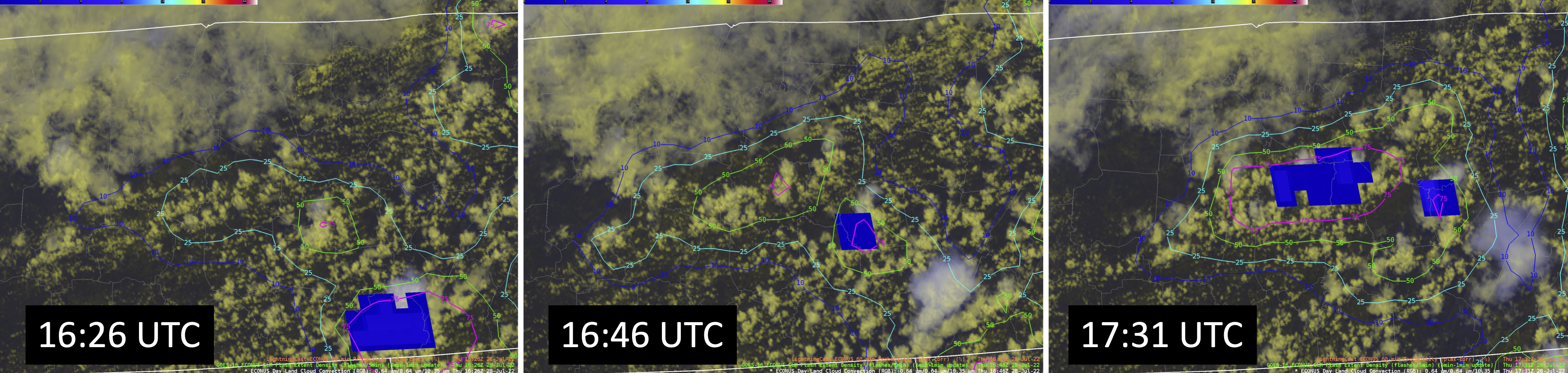
CIMSS supports the 2022 World Games with ProbSevere LightningCast: The Cooperative Institute for Meteorological Satellite Studies (CIMSS) supported the National Weather Service (NWS) in Birmingham, AL, with the experimental ProbSevere LightningCast model during the 2022 World Games from 7-17 July 2022, held in Birmingham, AL. The World Games are an international multi-sport event comprising sports that are not contested in the Olympic Games. They are usually held every four years, one year after the Summer Olympic Games. The games drew 500,000 attendees from over 100 countries. LightningCast uses GOES-R ABI images to predict the probability of lightning in the next hour at any given location. Despite LightningCast being an experimental product, early results were promising enough that the NWS in Birmingham asked CIMSS to provide tailored products and support during the games. The games experienced a number of thunderstorms affecting their operations, which resulted in the postponement of some events. In a post-games debrief, the NWS in Birmingham shared that LightningCast was very helpful in identifying areas of concern for lightning initiation. Forecasters said that they will keep using experimental near-real time LightningCast output during their normal operations. (J. Cintineo, CIMSS, cintineo@wisc.edu; M. Pavolonis, E/RA2, 608-263-9597, michael.pavolonis@noaa.gov; J. Sieglaff, CIMSS, justin.sieglaff@ssec.wisc.edu)
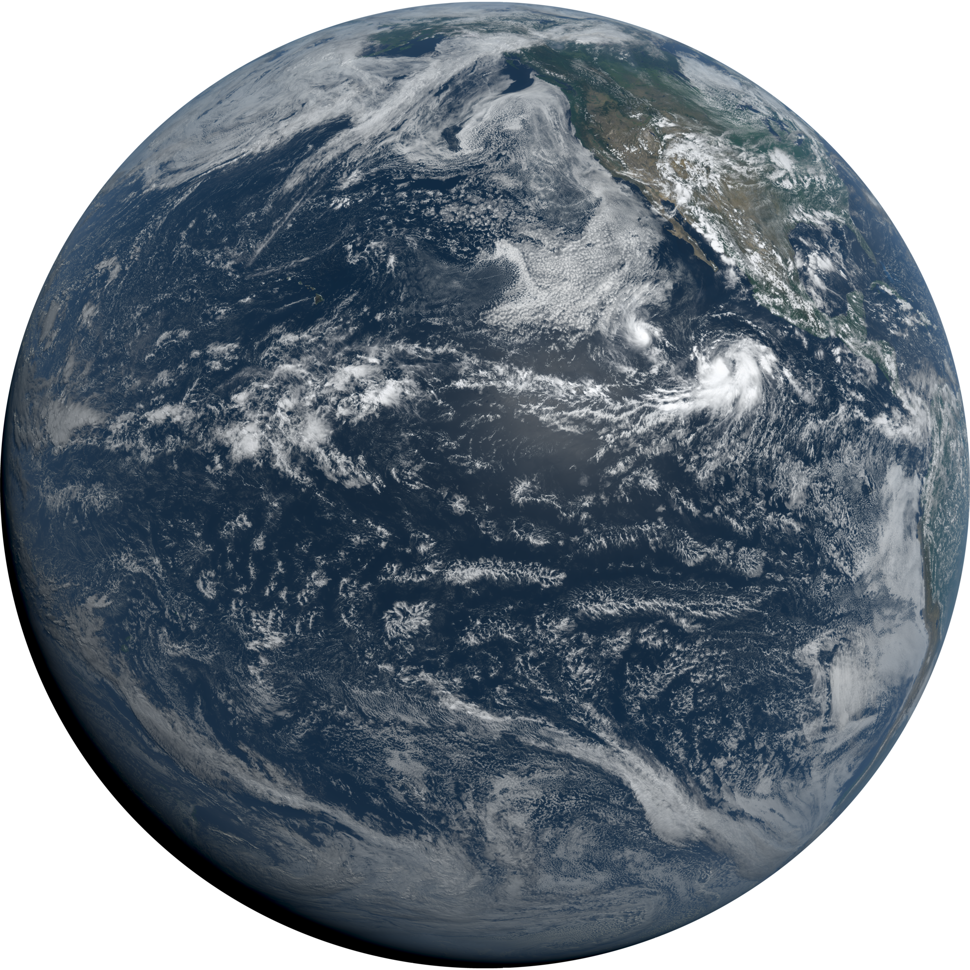
Milestone: GOES-18 ABI Imagery Reaches Provisional Maturity: Researchers from the Cooperative Institute for Meteorological Satellite Studies (CIMSS) and NOAA on the GOES-R Algorithm Working Group (AWG) Imagery team presented at the GOES-18 Advanced Baseline Imager (ABI) Provisional Peer Stakeholder-Product Validation Review (PS-PVR) on July 28, 2022. The Imagery Team is responsible for reporting the ABI Cloud and Moisture Imagery Product (CMIP) quality. Primary provisional status tests for imagery are that the GOES-18 ABI perform as well or better than comparable instruments, such as ABI on GOES-16 and GOES-17, and that there is computational consistency between the Level-1b radiances and the CMIP values (reflectance factor for visible/near-infrared bands and brightness temperature for the infrared bands). The GOES-18 ABI is performing well with few artifacts heading into August 2022 when GOES-18 imagery will temporarily replace GOES-17 ABI as the operational GOES-West for radiances and imagery (though not for any other level-2 products). GOES-18 Imagery and Radiances were declared provisional status after the review, which is a major Imagery Team milestone. More information will be posted at https://www.noaasis.noaa.gov/GOES/PS_PVR_GOES18.html. (M. Gunshor, CIMSS, T. Schmit, E/RA2, 608-263-0291, tim.j.schmit@noaa.gov)
 (Click image to enlarge)
Figure: GOES-18 ABI (Preliminary/Non-Operational) CIMSS Natural Color full disk image on July 28, 2022 at 20:00 UTC, just after the Provisional Status review. Larger image available: https://go.wisc.edu/bc25p1.
 (Click image to enlarge)
Figure: A sequence of images showing increasing probability of lightning from LightningCast (contours) before lightning is observed from the GOES-16 Geostationary Lightning Mapper (blue regions).
FUTURE OUTLOOK:
AWARDS AND RECOGNITION:
CubeSat OSSE study paper won best paper award: The 2019 paper "The alternative of CubeSat-based advanced infrared and microwave sounders for high impact weather forecasting" published in Atmospheric and Oceanic Science Letters and led by Zhenglong Li (Cooperative Institute for Meteorological Satellite Studies, CIMSS), won one of the six Best Paper Award 2022. The award is based on the number of Web of Science citations in the past three years. The paper carried out Observing Simulation Study Experiment (OSSE) studies for two CubeSat sensors: the Micro-sized Microwave Atmospheric Satellite-2 and the CubeSat Infrared Atmospheric Sounder (CIRAS). Their potential impacts on local severe storm forecasting was evaluated. The results show that larger spatial coverage from more CubeSats is more beneificial and they can potentially be used to mitigate the loss of conventional microwave or hyperspectral infrared sounders. (Z. Li, CIMSS, 608-890-1982; T. Schmit, E/RA2, 608-263-0291, tim.j.schmit@noaa.gov; P. Wang, CIMSS; A. Lim, CIMSS, 608-265-8620; Jinlong Li, CIMSS, 608-263-1555)
TRAVEL AND MEETINGS:
TRAINING AND EDUCATION:
VISIT Teletraining on Mesoscale Convective Vortices: Scott Lindstrom from the Cooperative Institute for Meteorological Satellite Studies (CIMSS) gave a Virtual Institute for Satellite Integration Training (VISIT) presentation to Patrick Chan of the National Hurricane Center on Mesoscale Convective Vortices (MCVs). The review/training helps to remind forecasters of the environment that supports the presence of MCVs, and helps them anticipate how forecast changes might be needed should an MCV appear where one if not forecast. (S. Lindstrom, CIMSS, 608 263 4425)
MEDIA INTERACTIONS AND REQUESTS:
SOCIAL MEDIA AND BLOG Posts:
PUBLICATIONS:
OTHER:
| Archived Weeklies Page | Submit a report item |