[ Archive ]
| CIMSS-NOAA Weekly Report [ Archive ] |
CIMSS AND ASPB WEEKLY HIGHLIGHTS FOR THE WEEK ENDING SEPTEMBER 30, 2022
DATA, INFORMATION, AND USE-INSPIRED SCIENCE:
CIMSS Tropical Cyclones Team Supports Hurricane Ian Forecasting: On Hurricane Ian's approach towards a landfall in Cuba, the NOAA National Hurricane Center (NHC) relied on up-to-the-minute, satellite-derived intensity estimates during a break in aircraft reconnaissance missions to upgrade the storm to Major Hurricane status. These estimates were provided by automated algorithms developed by the CIMSS Tropical Cyclones team at the University of Wisconsin-Madison. NHC Hurricane Ian Discussion Number 17, issued on Sept. 27, 2022 at 5:00 a.m. EDT, estimated Ian's landfall intensity and initial intensity at 110 knots: https://go.wisc.edu/dub62h. (C. Velden, CIMSS, T. Olander, CIMSS, D. Herndon, CIMSS, S. Griffin, CIMSS)
.png) (Click image to enlarge)
(Click image to enlarge)
Figure: Hurricane Ian Discussion Number 17. Credit: NWS, National Hurricane Center.
ProbSevere LightningCast created for American Samoa domain: John Cintineo from the Cooperative Institute for Meteorological Satellite Studies (CIMSS) has created a sector showing ProbSevere LightningCast Probability contours for a domain centered on American Samoa. The request for the domain came from Pacific Region Headquarters in Honolulu, and was created because limited computer resources prohibit the creation of GOES-17 Full Disk imagery of the product. The LightningCast sector for American Samoa is available at the RealEarth-powered display here: https://cimss.ssec.wisc.edu/severe_conv/pltg.html. At that site, select 'American Samoa' under the GOES-West sector. (J. Cintineo, CIMSS; S. Lindstrom CIMSS; M. Pavolonis, NOAA/NESDIS)
GOES-18 Provisional Reviews for Cloud Products: Scientists from the University of Wisconsin-Madison Cooperative Institute for Meteorological Satellite Studies (CIMSS) and NOAA/NESDIS/Center for Satellite Applications and Research (STAR) formally evaluated the Enterprise Cloud Mask (ECM), Enterprise Cloud Top Phase (ECP), and Baseline Cloud Top Pressure/Pressure/Temperature (CTP) products during a recent GOES-18 Provisional Review. All products were evaluated by using a multi-week dataset of GOES-18 observations from August 2022 to assess their performance against both co-located GOES-17 products and products derived from independent sensors. The GOES-18 ECM, ECP, and CTP products compared favorably against their respective evaluation datasets and passed established performance metrics. The ECM product passed the Provisional Review and was therefore deemed ready for operational use. An operational declaration for ECP and CTP products, however, was deferred until the source of an ECP cloud typing issue in the operational product generation system is identified and rectified. (M. Kulie, E/RA2, 608-263-6583, mark.kulie@noaa.gov)
FUTURE OUTLOOK:
AWARDS AND RECOGNITION:
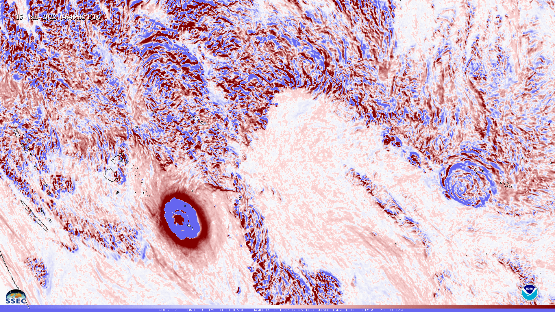
GOES-17 Animation Cool UW Science Winner: The GOES-R Series Algorithm Working Group (AWG) Imagery Team at the Cooperative Institute for Meteorological Satellite Studies (CIMSS), in partnership with the NESDIS Advanced Satellite Products Branch (ASPB), were named among the winners in the University of Wisconsin–Madison’s annual Cool Science Image Contest (https://news.wisc.edu/the-2022-winners-cool-science-image-contest/) for a time difference Geostationary Operational Environmental Satellite (GOES)-17 Advanced Baseline Imager (ABI)loop of the eruption of the Hunga Tonga volcano using McIDAS-X software. (Loop: http://cimss.ssec.wisc.edu/goes/YouTube_Tonga.html). The contest was sponsored by Madison’s Promega Corp., with additional support from UW–Madison’s office of University Communications. The winning entries are being exhibited through December at the McPherson Eye Research Institute's gallery on the ninth floor in the Wisconsin Institutes for Medical Research, 111 Highland Ave, Madison, Wisconsin. (T. Schmit, E/RA2, 608-263-0291)
 (Click image to enlarge)
Figure: A GOES-17 ABI band 9 (7.0 micrometers) time difference image showing the rings due to the eruption of the Hunga Tonga volcano.
TRAVEL AND MEETINGS:
TRAINING AND EDUCATION:
MEDIA INTERACTIONS AND REQUESTS:
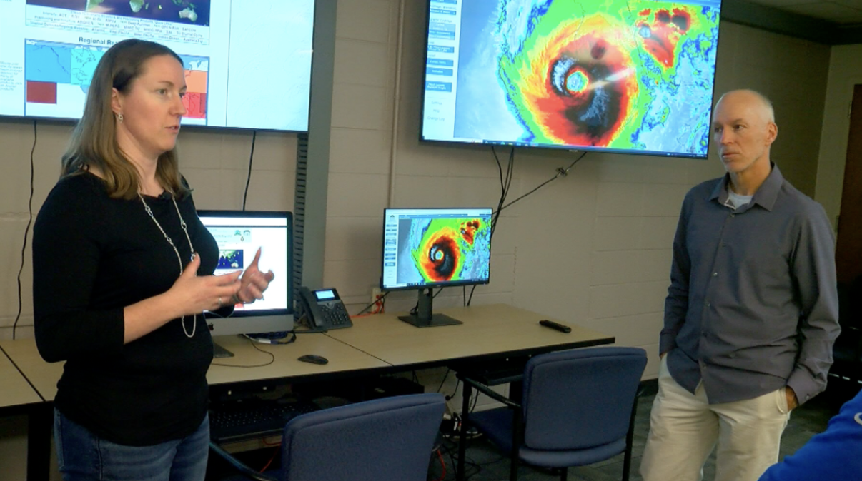
CIMSS tropical cyclone researcher interviews: Cooperative Institute for Meteorological Satellite Studies (CIMSS) tropical cyclone researcher Sarah Griffin was the UW News featured expert available to talk with reporters about Hurricane Ian. She spoke with hosts of WORT-FM Radio's 8 O'Clock Buzz-Thursday, Sept. 29 (https://archive.wortfm.org/, starts at 17:25), was joined by CIMSS researcher Derrick Herndon for an interview with Milwaukee's WTMJ-TV (https://go.wisc.edu/8946pj), and was interviewed by WMTV, NBC15 in Madison as well as WISN-12 in Milwaukee (https://go.wisc.edu/q68383). In addition, she worked with UW News to record a video for distribution by the Associated Press. Derrick Herndon will be a guest on Wisconsin Public Radio's Central Time on Friday, Sept. 30, 2022 (https://www.wpr.org/predicting-hurricane-paths-and-intensification).
 (Click image to enlarge)
Figure: WTMJ-TV Milwaukee interviewed CIMSS scientists Sarah Griffin and Derrick Herndon about Hurricane Ian and analyses provided to the National Hurricane Center by the CIMSS Tropical Cyclones team to support forecasts for the storm. Credit: TMJ4.
SOCIAL MEDIA AND BLOG Posts:
SSEC and CIMSS Scientists in the News: Scientists at the University of Wisconsin-Madison (UW) Space Science and Engineering Center (SSEC) and the Cooperative Institute for Meteorological Satellite Studies (CIMSS) provide expert interviews, imagery and case studies to promote science. This week:
 (Click image to enlarge)
Figure: Overlapping one-minute mesoscale domain sectors provided 30-second interval GOES-16 infrared and visible images during a seven-hour period that included the landfall of Hurricane Ian along the Southwest coast of Florida on Sept. 28, 2022. Credit: NOAA, CIMSS.
PUBLICATIONS:
OTHER:
| Archived Weeklies Page | Submit a report item |