[ Archive ]
| CIMSS-NOAA Weekly Report [ Archive ] |
CIMSS AND ASPB WEEKLY HIGHLIGHTS FOR THE WEEK ENDING NOVEMBER 18, 2022
DATA, INFORMATION, AND USE-INSPIRED SCIENCE:
FUTURE OUTLOOK:
AWARDS AND RECOGNITION:
Schmit and Heidinger Receive NOAA Awards: Tim Schmit (STAR) and Andy Heidinger (GeoXO) were part of a group that received the 2022 Department of Commerce Bronze Medal "For ensuring that NOAA’s next generation geostationary satellite system will meet the most critical observing needs for our nation and partners." The award recognizes federal employees for superior performance and is awarded to individuals, groups (or teams), and organizations. Heidinger also received the NOAA Administrator's Award "For developing and providing satellite cloud fields for solar energy applications, including the siting of solar collectors in North and South America." The Administrator's Award recognizes employees who have demonstrated exceptional leadership, skill, and ingenuity in their significant, unique, and original contributions that bring unusual credit to NOAA, DOC, and the Federal Government. (J. Key, E/RA2, 608-263-2605, jeff.key@noaa.gov)
TRAVEL AND MEETINGS:
GOES-R program scientist visits CIMSS: Dr. Dan Lindsey, the GOES-R program scientist, visited the Cooperative Institute for Meteorological Satellite Studies (CIMSS) on 18 November 2022. Dr. Lindsey provided updates on the GOES-R and GeoXO programs, and discussed recent progress with CIMSS scientists on their NOAA/NASA ROSES projects. (J. Key, E/RA2, 608-263-2605, jeff.key@noaa.gov)
CIMSS presentations at 12th AOMSUC in Tokyo: Scott Lindstrom from the Cooperative Institute for Meteorological Satellite Studies (CIMSS) gave two oral presentations at the 12th Asia-Oceania Meteorological Satellite Users' Conference (AOMSUC-12) held 15-17 November 2022 in Tokyo Japan, and remotely. The first presentation detailed ProbSevere LightningCast Probability as used in the forecast office on Guam (available at https://cimss.ssec.wisc.edu/severe_conv/pltg.html), and the second presentation discussed efforts at CIMSS to repackage Altimetric Heights, Advanced Scatterometer (ASCAT) winds, and Advanced Microwave Scanning Radiometer-2 (AMSR-2) Wind Speeds at the NESDIS/STAR manati website (https://manati.star.nesdis.noaa.gov/) into a format that shows larger domains over longer time periods. The recorded ten-minute presentations were followed by live Q&A from conference participants. (S. Lindstrom, CIMSS, 608 263 4425)
TRAINING AND EDUCATION:
Satellite Training at WSO Pago Pago: Scott Lindstrom from the Cooperative Institute for Meteorological Satellite Studies (CIMSS) was at the Weather Service Office (WSO) in Pago Pago, American Samoa, on 11 November 2022, and from 14-18 November to provide in-person training. Part of the training was solely on Satellite Meteorology and products for a new hire, and part of the training (for the entire staff) was a refresher on various satellite products available in the office. The all-office training also included tips on how to prepare for flooding events, on what products to use during the upcoming tropical cyclone season, and on satellite imagery (and websites) that could be useful during Volcanic eruptions, and how various RGB products can be useful for convective monitoring. Incorporation of GOES-17 Level 2 products into the forecast process and into AWIPS procedures was also demonstrated and discussed. The training was at the request of Pacific Region and WSO Pago Pago management. (S. Lindstrom, CIMSS, 608 263 4425)
AOMSUC-12 Training on NOAA flood products: William Straka participated in the training course at the 12th Asia Oceania Meteorological Satellite Users’ Conference (AOMSUC-12) on 14 November 2022 (UTC/Japan time), presenting on the NOAA Flood Products and their usage for response to flood events, which often occur in the Asia Oceania region, especially in South East Asia. This included a formal presentation with questions for the audience as well as a hands on demonstration of the NOAA Flood website (https://www.ssec.wisc.edu/flood-map-demo/). This training resulted in several interactions with other meteorological agencies in the Asia Oceania interested in utilizing the NOAA Flood products for their applications, including a WMO initiative in Indonesia. (W. Straka III, CIMSS)
UW AOS Lecture on GOES: T. Schmit gave a lecture in the University of Wisconsin-Madison Atmospheric and Oceanic Sciences (AOS) Department's course Weather Satellite Applications (AOS-745). The title was "Geostationary Operational Environmental Satellite (GOES): How It Started and How It’s Going". Both geostationary imagers and sounders were covered. (T. Schmit, E/RA2, 608-263-0291, tim.j.schmit@noaa.gov)
 (Click image to enlarge)
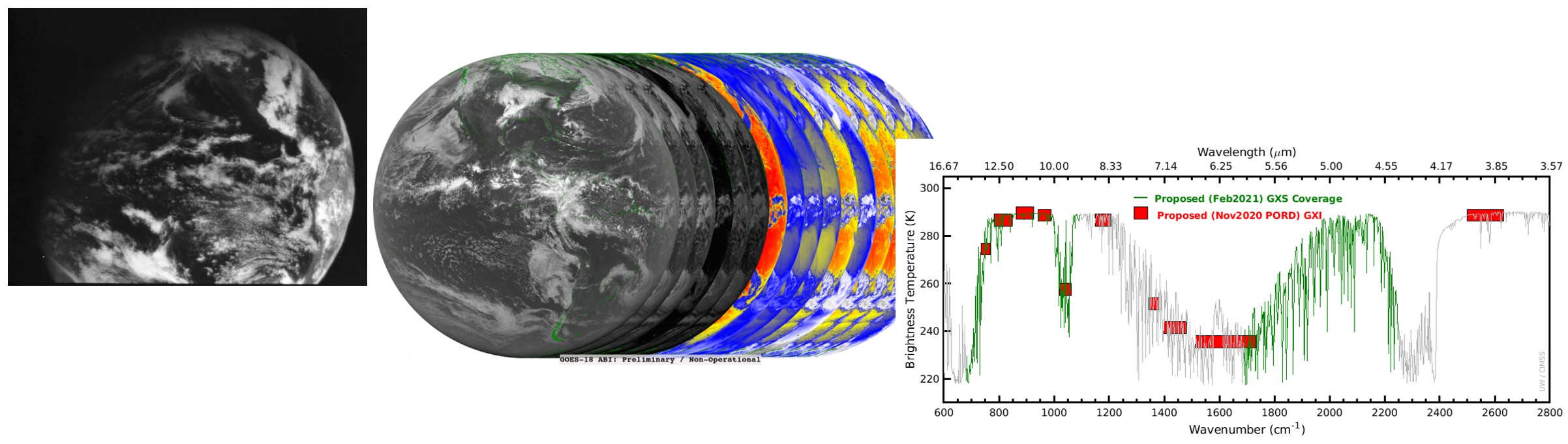
Figure: A 3-panel image showing the progression from the single channel ATS-1 to the 16-panel Advanced Baseline Imager to the spectral coverage of the planned GeoXO Imager and Sounder.
MEDIA INTERACTIONS AND REQUESTS:
SOCIAL MEDIA AND BLOG Posts:
SSEC and CIMSS Scientists in the News: Scientists at the University of Wisconsin-Madison (UW) Space Science and Engineering Center (SSEC) and the Cooperative Institute for Meteorological Satellite Studies (CIMSS) provide expert interviews, imagery and case studies to promote science. This week:
 (Click image to enlarge)
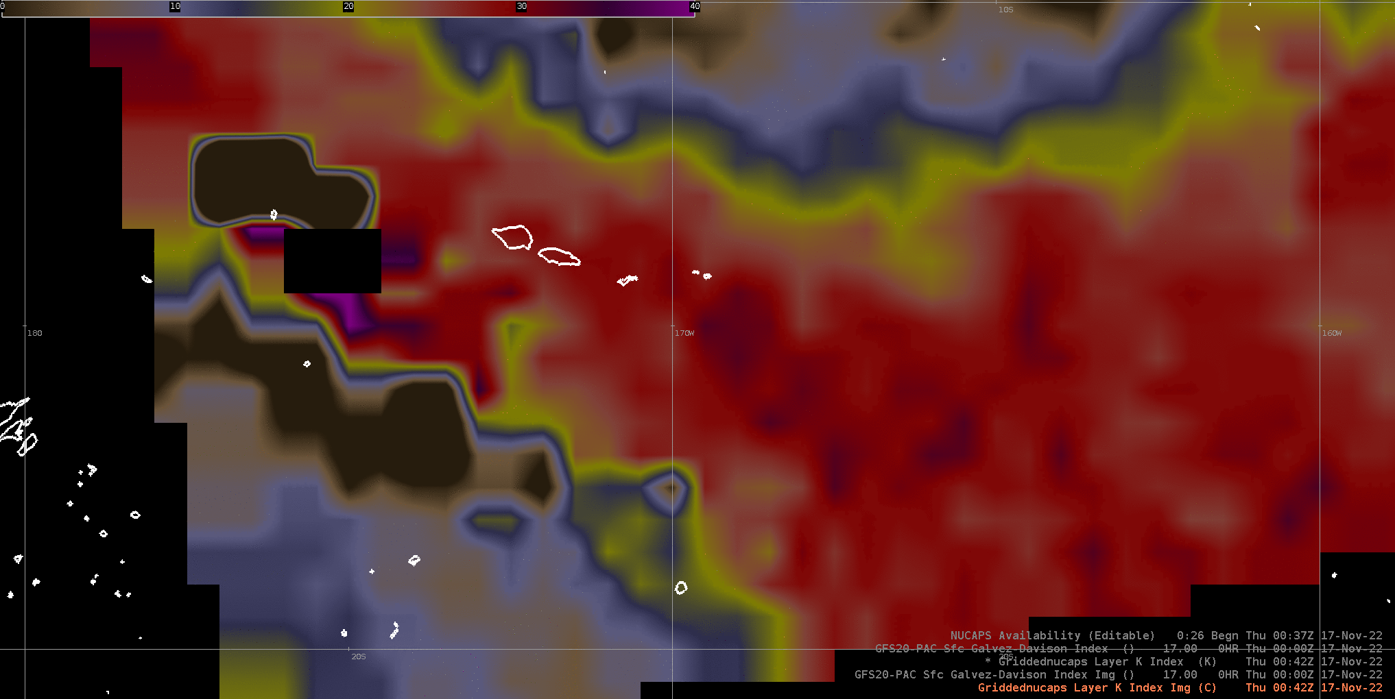
Figure: Comparing the Galvez-Davison Index with K-Index derived from NOAA Unique Combined Atmospheric Processing System (NUCAPS) data shows good spatial correlation between the GDI and the diagnosed stability on Nov. 17, 2022. Read more at the CIMSS Satellite Blog: https://cimss.ssec.wisc.edu/satellite-blog/archives/48755. Credit: CIMSS, NOAA.
 (Click image to enlarge)
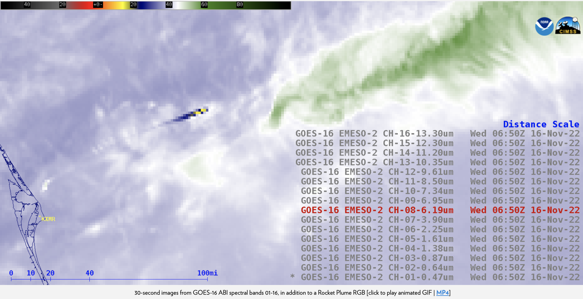
Figure: Visible reflectance and/or thermal signatures of NASA's Artemis Space Launch System rocket booster were seen in all 16 of the GOES-16 Advanced Baseline Imager spectral bands as well as the RGB imagery on Nov. 16, 2022. Read more at the CIMSS Satellite Blog: https://cimss.ssec.wisc.edu/satellite-blog/archives/48732. Credit: CIMSS, NOAA.
PUBLICATIONS:
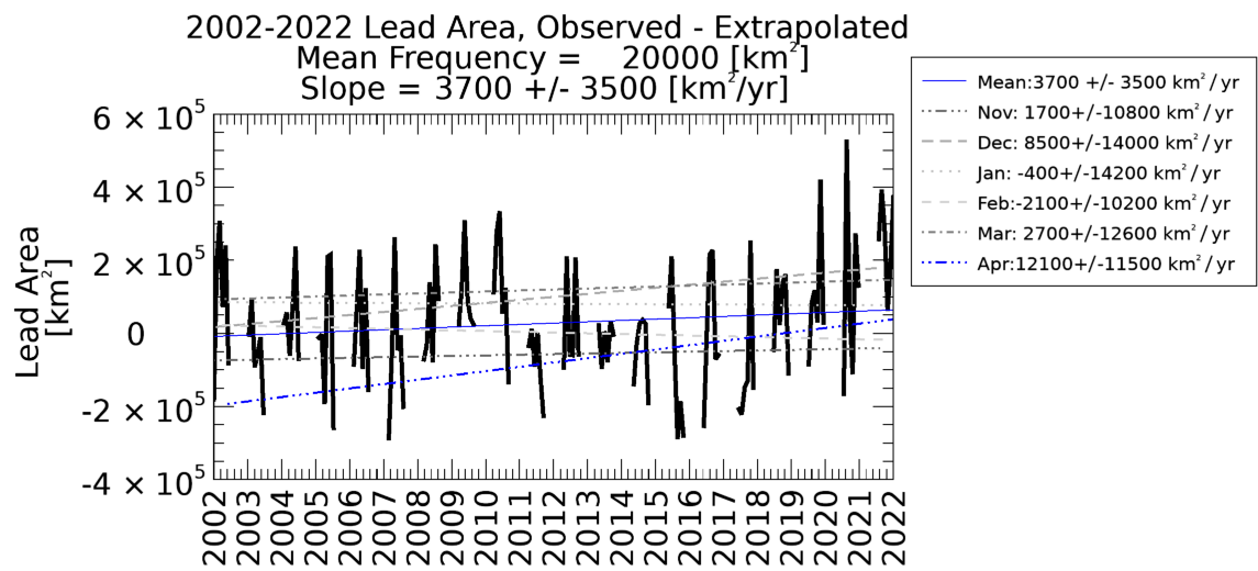
Manuscript on Sea Ice Leads Climatology Published: A manuscript "A 20-Year Climatology of Sea Ice Leads Detected in Infrared Satellite Imagery Using a Convolutional Neural Network", has been published in the journal Remote Sensing. The authors Jay Hoffman (CIMSS), Steve Ackerman (CIMSS), Yinghui Liu (ASPB), and Jeff Key (ASPB) suggest that although leads are becoming increasingly difficult to detect due to increasing clouds, a small increase in lead area has been identified. More information on the project is available at https://www.ssec.wisc.edu/leads. Citation: Hoffman, J., S.A. Ackerman, Y. Liu, and J. Key, 2022, A 20-Year Climatology of Sea Ice Leads Detected in Infrared Satellite Imagery Using a Convolutional Neural Network, Remote Sens., 4(22), 5763; https://doi.org/10.3390/rs14225763. (J. Hoffman, CIMSS, 608-890-1690)
 (Click image to enlarge)
Figure: The difference between observed and extrapolated leads area as a function of clear sky percentage, showing that lead detections are decreasing more than would be expected based only on increasing clouds.
OTHER:
| Archived Weeklies Page | Submit a report item |