[ Archive ]
| CIMSS-NOAA Weekly Report [ Archive ] |
CIMSS AND ASPB WEEKLY HIGHLIGHTS FOR THE WEEK ENDING DECEMBER 16, 2022
DATA, INFORMATION, AND USE-INSPIRED SCIENCE:
VIIRS and LEO-GEO Winds are Operational at NCEP: The VIIRS polar winds and the LEO-GEO winds are now actively assimilated in NCEP's Global Forecast System (GFS). The VIIRS winds provide tropspheric wind information poleward of about 65 degrees latitude. The LEO-GEO winds combine polar-orbiting and geostationary satellites to extend the coverage further equatorward and fill the gap between the typical geostationary and polar winds coverage, approximately 55-65 degrees latitude. NCEP experiments have shown that the LEO-GEO winds have a positive impact on forecasts, especially in the Southern Hemisphere. The impact of the VIIRS winds is largely neutral, though it was found that not assimilating them resulted in forecast degradations for some weather events. (We note that some other numerical weather prediction centers, such as the Naval Research Laboratory, have shown an overall positive impact of the VIIRS winds.) (J. Key, E/RA2, 608-263-2605, jeff.key@noaa.gov; D. Santek, CIMSS, 608-263-7410; Iliana Genkova, NCEP)
FUTURE OUTLOOK:
AWARDS AND RECOGNITION:
TRAVEL AND MEETINGS:
CIMSS Satellite Blog Imagery on the Australian VLab COE Regional Focus Group Year in Review: Scott Lindstrom from the Cooperative Institute for Meteorological Satellite Studies (CIMSS) was one of the presenters at this month's Regional Focus Group, organized by Mr. Bodo Zeschke at the Australian VLab Center of Excellence, that focused on the most interesting satellite imagery of the year. Scott's presentations highlighted Synthetic Aperture Radar observations near Guam (as discussed here: https://cimss.ssec.wisc.edu/satellite-blog/archives/48916); the use of Nighttime Microphysics RGB to monitor convective initiation over the south Pacific (as discussed here: https://cimss.ssec.wisc.edu/satellite-blog/archives/48722); LightningCast Probabilities around Guam (as discussed here: https://cimss.ssec.wisc.edu/satellite-blog/archives/48218); and comparing the sizes of Hurricanes Charley (2004) and Ian (2022) at landfall (as discussed here: https://cimss.ssec.wisc.edu/satellite-blog/archives/48129). Other presenters were from JMA, the Met Service of New Zealand, and NOAA. The presentation was recorded and will be available at http://www.virtuallab.bom.gov.au/archive/regional-focus-group-recordings/. (S. Lindstrom, CIMSS, 608 263 4425)
TRAINING AND EDUCATION:
MEDIA INTERACTIONS AND REQUESTS:
SOCIAL MEDIA AND BLOG Posts:
SSEC and CIMSS Scientists in the News: Scientists at the University of Wisconsin-Madison (UW) Space Science and Engineering Center (SSEC) and the Cooperative Institute for Meteorological Satellite Studies (CIMSS) provide expert interviews, imagery and case studies to promote science. This week: 1) CIMSS Scientist Tom Greenwald is improving the spatial resolution of Arctic sea ice imagery to paint a clearer picture of environmental change. SSEC News published this story: https://www.ssec.wisc.edu/news/articles/14907/. 2) CIMSS Satellite Blog contributors Scott Lindstrom and Scott Bachmeier published these case studies: "IntenseStormNet with severe weather in the deep south" (Dec. 14), "Launch of EUMETSAT MTG-I1" (Dec. 13), "Comparing AGRI, AMI and AHI imagery with geo2grid version 1.1" (Dec. 13), "True-color imagery with FY4A and Himawari-9 data using geo2grid version 1.1" (Dec. 12), "Satellite signature of strong surface winds over the West Atlantic Ocean" (Dec 12), "Hurricane Force low in the North Atlantic Ocean" (Dec. 10), "How to make Brightness Temperature Difference fields with Geo2grid" (Dec. 9) and "Lake effect cloud plume in northeastern Montana" (Dec. 8). Read more at the CIMSS Satellite Blog: https://cimss.ssec.wisc.edu/satellite-blog/. (T. Greenwald, CIMSS, L. Avila, CIMSS, S. Lindstrom, CIMSS, S. Bachmeier, J. Phillips, SSEC, 608-262-8164)
 (Click image to enlarge)
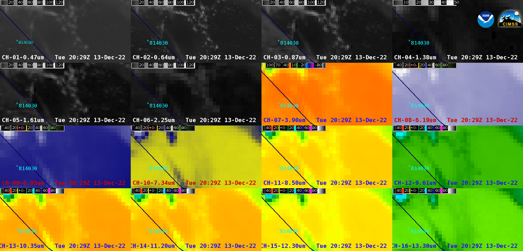
Figure: 16-panel images showing all GOES-16 ABI spectral bands showed signatures of the launch of EUMETSAT's MTG-I1. Read more at the CIMSS Satellite Blog: https://cimss.ssec.wisc.edu/satellite-blog/archives/49206. Credit: CIMSS, NOAA.
 (Click image to enlarge)
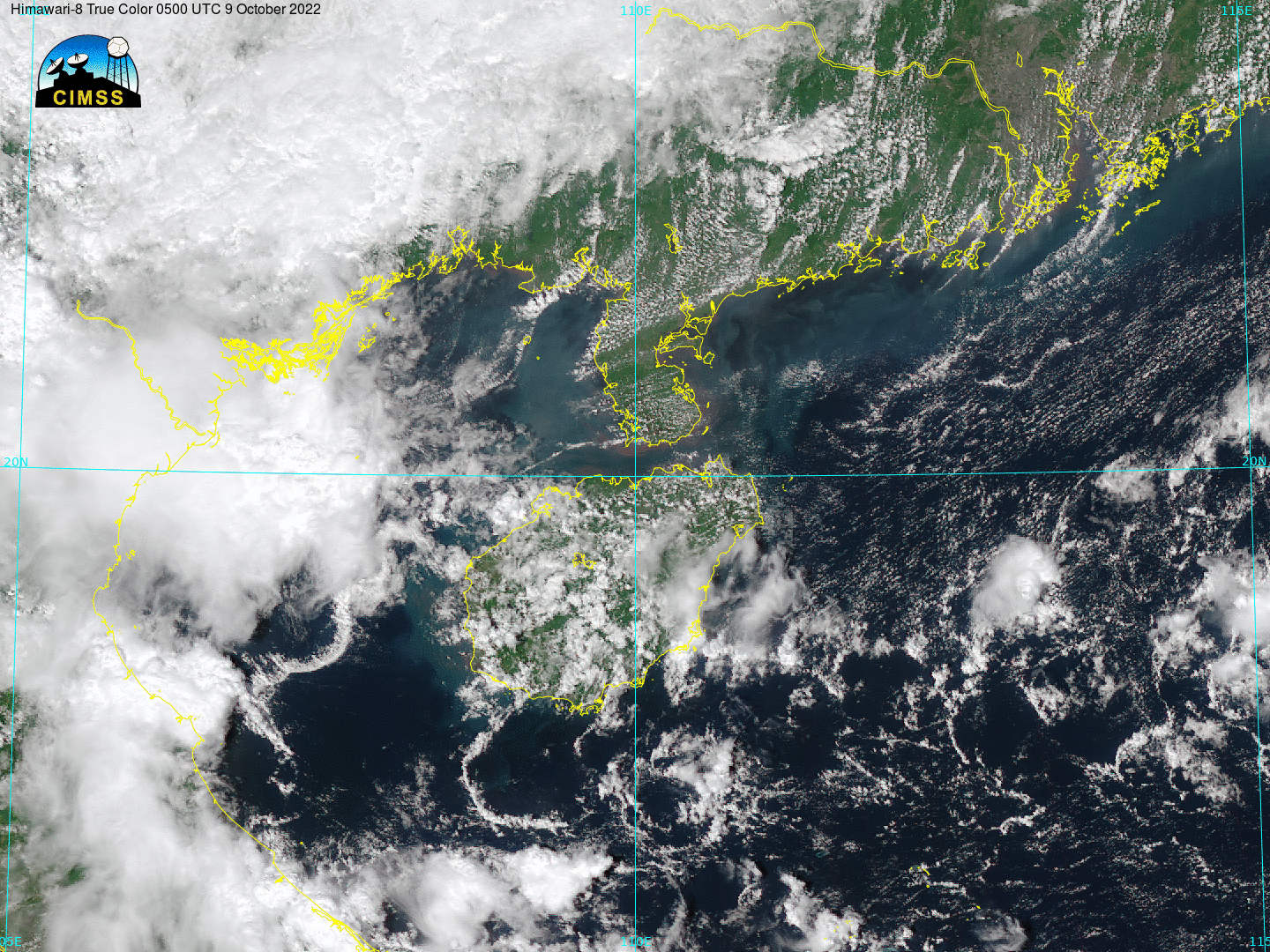
Figure: Geo2Grid, developed at CIMSS, supports the comparison of imagery from the Advanced Meteorological Imager (KMA), Advanced Himawari Imager (JMA) and the Advanced Geostationary Radiation Imager (CMA) as seen in this animation over Hainan Island and the Gulf of Tonkin on Dec. 13, 2022. Read more at the CIMSS Satellite Blog: https://cimss.ssec.wisc.edu/satellite-blog/archives/49213. Credit: CIMSS, KMA, JMA, CMA.
PUBLICATIONS:
OTHER:
| Archived Weeklies Page | Submit a report item |