[ Archive ]
| CIMSS-NOAA Weekly Report [ Archive ] |
CIMSS AND ASPB WEEKLY HIGHLIGHTS FOR THE WEEK ENDING JANUARY 6, 2023
DATA, INFORMATION, AND USE-INSPIRED SCIENCE:
FUTURE OUTLOOK:
AWARDS AND RECOGNITION:
TRAVEL AND MEETINGS:
TRAINING AND EDUCATION:
MEDIA INTERACTIONS AND REQUESTS:
SOCIAL MEDIA AND BLOG Posts:
SSEC and CIMSS Scientists in the News: Scientists at the University of Wisconsin-Madison (UW) Space Science and Engineering Center (SSEC) and the Cooperative Institute for Meteorological Satellite Studies (CIMSS) provide expert interviews, imagery and case studies to promote science. This week: 1. The National Weather Service Forecast Office in Sioux Falls, South Dakota picked up a GOES-16 animation created by CIMSS Scientist Scott Bachmeier, including it in their analysis of recent, record-setting snowfall that was enhanced by thundersnow: https://www.weather.gov/fsd/20230103-HeavySnow-CWA. 2. CIMSS Satellite Blog contributors Tim Schmit, Alexa Ross, Scott Bachmeier and Scott Lindstrom published these case studies: "The Pantheon of GOES" (Jan. 5), "California Gets Rain: a GOES view" (Jan. 5), "Rapidly intensifying Hurricane Force low off the US West Coast" (Jan. 4), "GOES-18 IFR Probability Fields now operational" (Jan. 4), "Thundersnow in the Upper Midwest, and 30-second imagery of severe thunderstorm across the Deep South" and "There GOES 2022" (Dec. 31). Read more at the CIMSS Satellite Blog: https://cimss.ssec.wisc.edu/satellite-blog/. (S. Bachmeier, CIMSS, A. Ross, SSEC, T. Schmit, E/RA2, 608-263-0291,S. Lindstrom, SSEC, J. Phillips, SSEC, 608-262-8164)
 (Click image to enlarge)
Figure: GOES-18 became operational as GOES-West on Jan. 4, 2023. This retrospective shows all of the satellites in the series, dating to 1975 and represents the importance of continuity for NOAA operational satellites. Read more at the CIMSS Satellite Blog: https://cimss.ssec.wisc.edu/satellite-blog/archives/46161. Credit: CIMSS, NOAA.
(Click image to enlarge)
Figure: GOES-16 mid-level water vapor images along with Geostationary Lightning Mapper flash extent density showed a widespread winter storm that produced thundersnow in parts of Nebraska, Iowa, South Dakota and Minnesota on Jan. 3, 2023. Read more at the CIMSS Satellite Blog: https://cimss.ssec.wisc.edu/satellite-blog/archives/49673. Credit: CIMSS, NOAA.
PUBLICATIONS:
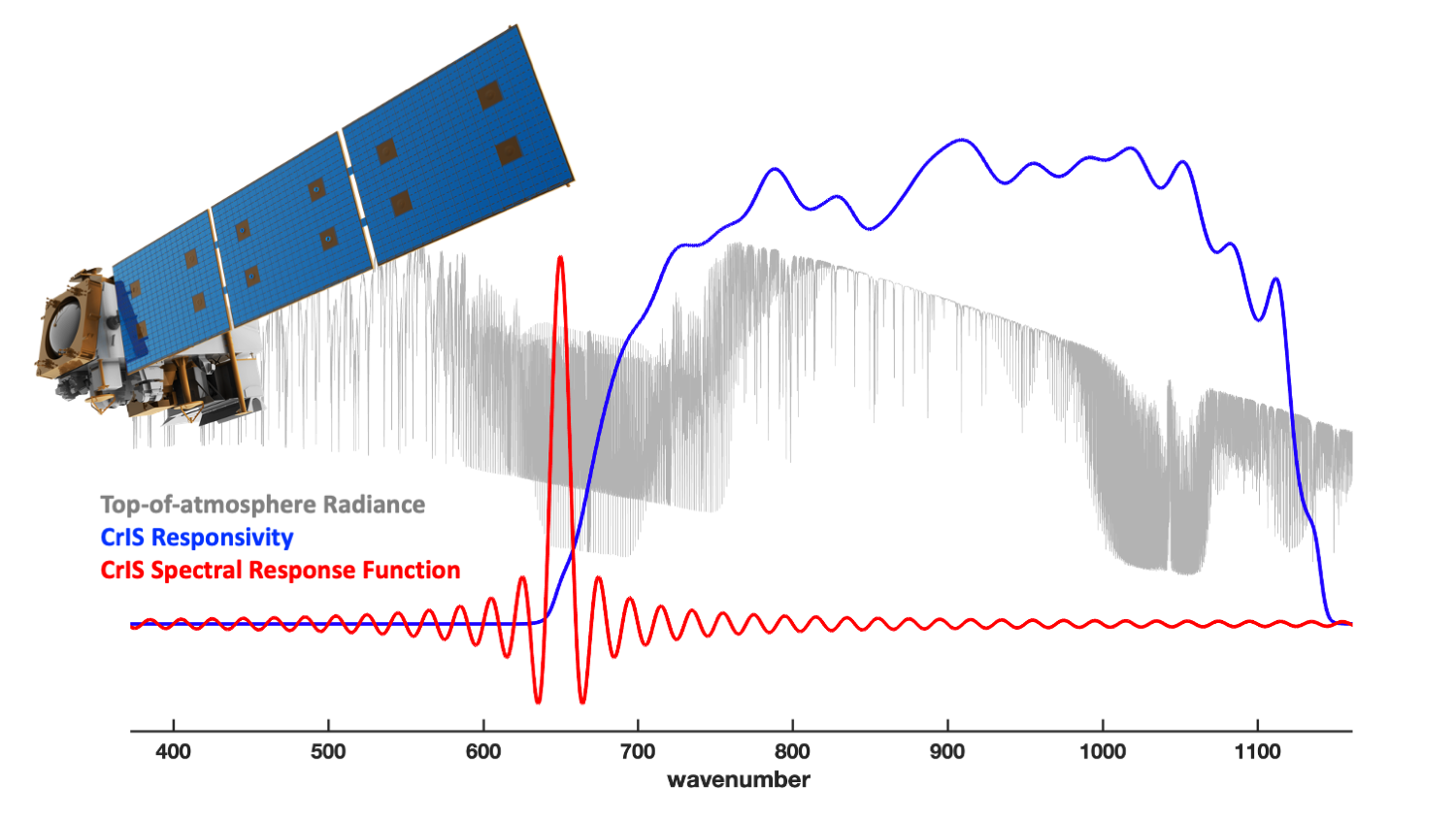
Paper on Simulation of CrIS Radiances Published: A paper titled “Simulation of CrIS [Cross-track Infrared Sounder) Radiances Accounting for Realistic Properties of the Instrument Responsivity That Result in Spectral Ringing Features” by authors Lori Borg, Michelle Loveless, Robert Knuteson, Hank Revercomb, Joe Taylor, Yong Chen, Flavio Iturbide-Sanchez, and David Tobin, was published in Remote Sensing as part of the Special Issue on Satellite Data Application, Validation, and Calibration for Atmospheric Observation II. The paper provides a procedure for the simulation of radiances from the NOAA Cross-track Infrared Sounder (CrIS) Fourier Transform Spectrometer to include spectral ringing effects caused by the finite-band, non-flat instrument spectral response to incident radiation. Users of CrIS radiances should consider whether this effect is important for their application. Citation: Borg L., M. Loveless, R. Knuteson, H. Revercomb, J. Taylor, Y. Chen, F. Iturbide-Sanchez, and D. Tobin, 2023, Simulation of CrIS Radiances Accounting for Realistic Properties of the Instrument Responsivity That Result in Spectral Ringing Features, Remote Sensing, 15(2):334. https://doi.org/10.3390/rs15020334. (D. Tobin, CIMSS, 608-265-6281, dave.tobin@ssec.wisc.edu)
 (Click image to enlarge)
Figure: Graphical abstract for Borg et al. (2023).
OTHER:
| Archived Weeklies Page | Submit a report item |