[ Archive ]
| CIMSS-NOAA Weekly Report [ Archive ] |
CIMSS AND ASPB WEEKLY HIGHLIGHTS FOR THE WEEK ENDING FEBRUARY 3, 2023
DATA, INFORMATION, AND USE-INSPIRED SCIENCE:
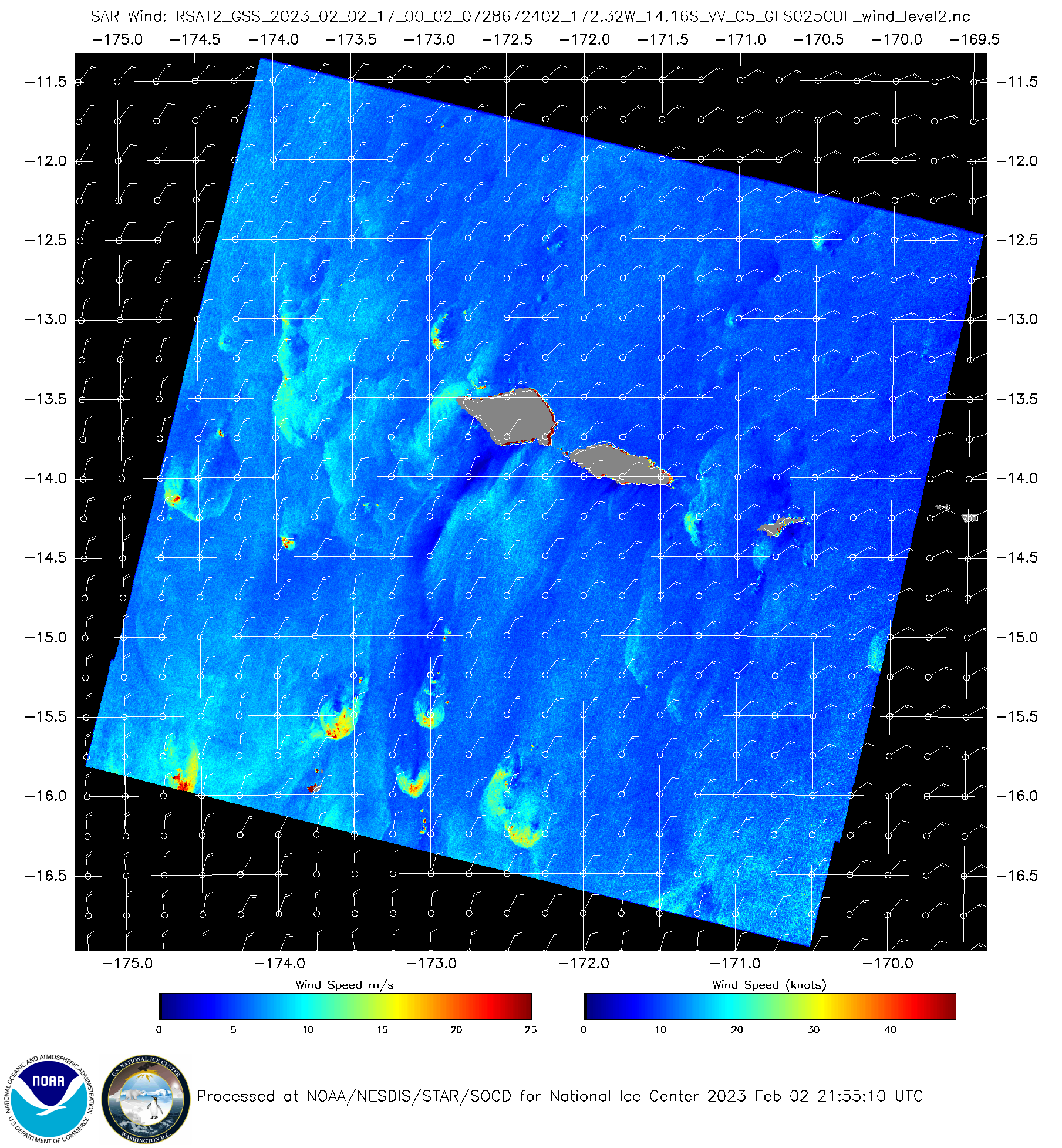
SAR Wind Observations over American Samoa begin: At the request of the NOAA NWS Office of Observations, members of the Water Surface Conditions / Synthetic Aperture Radar (WSC/SAR) Science Team (WSC/SAR) have tasked Radarsat-2 to acquire SAR imagery over American Samoa between 30 January and 5 March 2023 (19 collections over 9 dates). The WSC/SAR team converts these collection into maps of high resolution (500m) ocean surface wind speed. (Images are available at: https://coastwatch.noaa.gov/SAR/sar_winds_rcm.html.) Scott Lindstrom from the Cooperative Institute for Meteorological Satellite Studies (CIMSS) presented a short webinar on the advanced capabilities of SAR wind observations to forecasters at the NWS office in Pago Pago on 31 January 2023 and also published on the CIMSS Satellite Blog an initial blog post on those SAR observations (https://cimss.ssec.wisc.edu/satellite-blog/archives/50095). (S. Lindstrom, CIMSS, 608 263 4425; J. Gerth, NWS/OBS; Christopher Jackson, Tyler Ruff, and Jessie Moore Torres, WSC/SAR)
 (Click image to enlarge)
Figure: RADARSAT-2 derived Synthetic Aperture Radar (SAR) Winds at 1700 UTC on 2 February 2023 over the Samoan Islands.
FUTURE OUTLOOK:
AWARDS AND RECOGNITION:
TRAVEL AND MEETINGS:
TRAINING AND EDUCATION:
MEDIA INTERACTIONS AND REQUESTS:
SOCIAL MEDIA AND BLOG Posts:
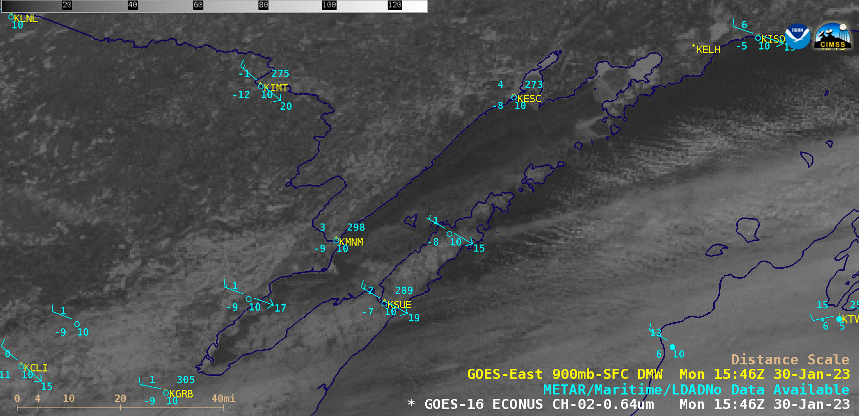
SSEC and CIMSS Scientists in the News: Scientists at the University of Wisconsin-Madison (UW) Space Science and Engineering Center (SSEC) and the Cooperative Institute for Meteorological Satellite Studies (CIMSS) provide expert interviews, imagery and case studies to promote science. This week: 1) CIMSS Satellite Blog contributors Scott Lindstrom, Alexa Ross and Scott Bachmeier published these case studies: "Global mean values of ABI Bands" (Feb. 2), "LIS observations just east of Japan" (Feb. 1), "Eruption of the East Epi submarine volcano" (Fewb. 1), "Using VIIRS and ABI to Monitor Northern California Flooding in RealEarth" (Jan. 31), "Transport of ice floes from Green Bay into Lake Michigan" (Jan. 30), "Lake effect Bands and one Convergence Band over Lake Superior" (Jan. 30), "Flooding in Auckland New Zealand" (Jan. 30) and "Flash flooding across parts of Hawai’i" (Jan. 28). Read more at the CIMSS Satellite Blog: https://cimss.ssec.wisc.edu/satellite-blog/. (S. Lindstrom, CIMSS, S. Bachmeier, CIMSS, A. Ross, SSEC, J. Phillips, SSEC, 608-262-8164)
 (Click image to enlarge)
Figure: GOES-16 images, along with plots of GOES-16 derived motion winds, showed the eastward transport of several ice floes from the northern Green Bay into Lake Michigan on Jan. 30, 2023. Read more at the CIMSS Satellite Blog: https://cimss.ssec.wisc.edu/satellite-blog/archives/50094. Credit: CIMSS, NOAA.
PUBLICATIONS:
OTHER:
| Archived Weeklies Page | Submit a report item |