[ Archive ]
| CIMSS-NOAA Weekly Report [ Archive ] |
CIMSS AND ASPB WEEKLY HIGHLIGHTS FOR THE WEEK ENDING FEBRUARY 24, 2023
DATA, INFORMATION, AND USE-INSPIRED SCIENCE:
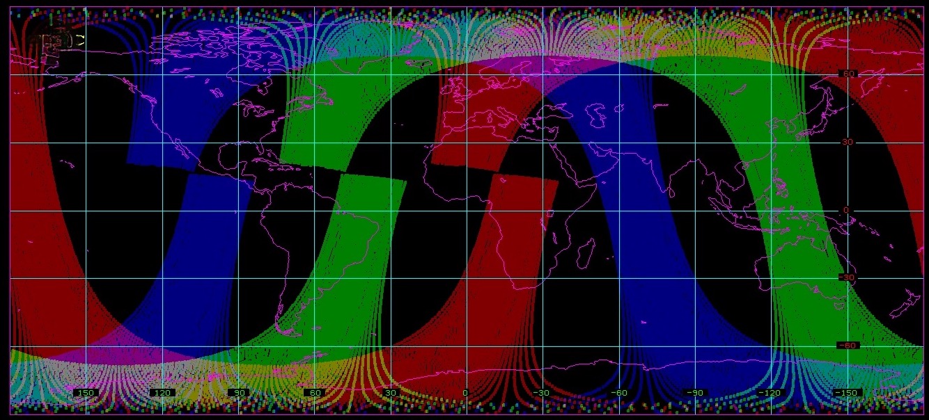
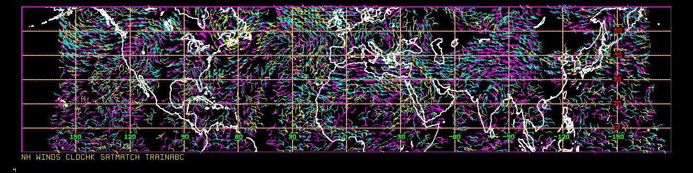
The Generation of Simulated AMVs from Future Satellite Configurations: A configurable and modular system is in development at the Cooperative Institute for Meteorological Satellite Studies (CIMSS) to generate 3D atmospheric motion vectors (AMVs) for use in Observing System Simulation Experiments (OSSEs) and to aid in making informed decisions for future satellite missions. The AMVs are derived by tracking humidity features on pressure surfaces from model output grids (e.g., a Nature Run (NR)). The next two steps filter the winds based on instrument type and orbit. For instance, to simulate winds from tracking features in hyperspectral IR humidity retrievals, the NR cloud top grid is used to retain only those AMVs that are in clear-sky or above-cloud. The final step discards AMVs that are not viewable from the satellite, using satellite orbit information and instrument scanning characteristics. This system was used to generate AMVs for June and July 2016 with this scenario: Three low earth orbit (LEO) constellations of satellites with hyperspectral IR sensors, in orbits offset by four hours (first figure). The European Centre for Medium-Range Weather Forecasts (ECMWF) Cubic Octahedral grid Nature Run (ECO1280) was used to generate the AMVs, filter the AMVs based on the cloud-top grid, and then the winds were sampled using the NOAA-20 orbit and the Cross-track Infrared Sounder (CrIS) scanning geometry. An example of the northern hemisphere AMV coverage in a three-hour time window is depicted in the second figure, which indicates that the above configuration using SmallSats with hyperspectral IR sounders will result in continuous global 3D winds coverage for data assimilation applications (D. Santek, CIMSS, 608-263-7410, T. Olander, CIMSS, S. Reiner, SSEC)
 (Click image to enlarge)
Figure: Polar-orbiting satellite swath coverage for a single orbit (100 minutes) from three satellite constellations at local equator crossing times of 0530 (red), 0930 (green), and 1330 (blue). The 1330 orbit is for NOAA-20 and the swath width is based on the CrIS instrument. The other two orbits were computed by modifying the right ascension of the ascending node of the NOAA-20 orbit.
 (Click image to enlarge)
Figure: AMVs derived from the ECO1280 in a three-hour time window covering latitudes from the equator to 60N. Yellow AMVs are below 700 hPa; cyan 400-700 hPa; and magenta above 400 hPa.
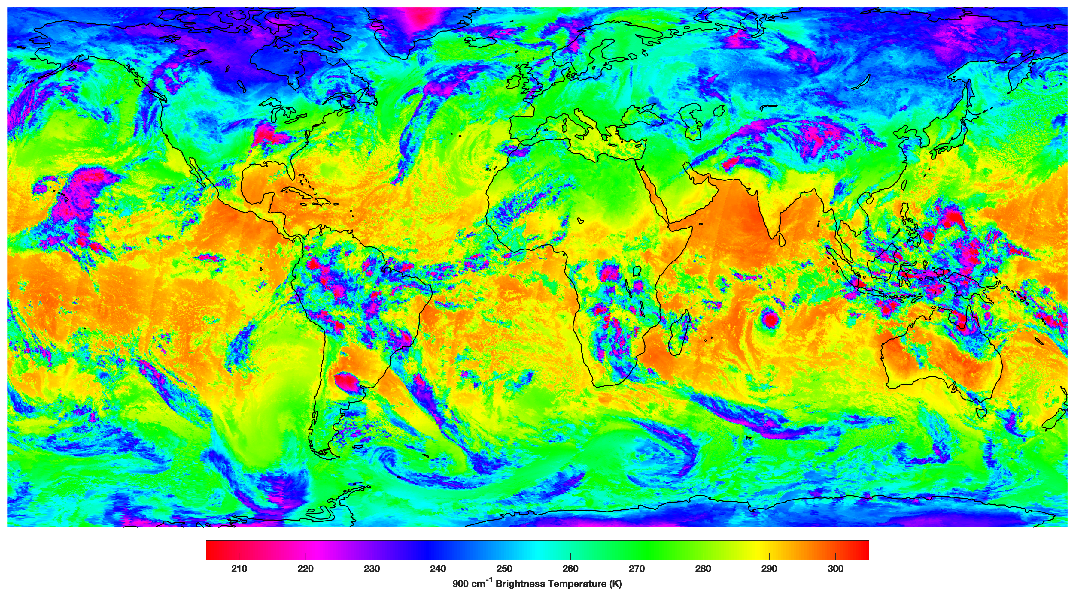
CIMSS Contributions to NOAA-21 CrIS Early Orbit Checkout: The Cross-track Infrared Sensor (CrIS) on NOAA-21 started collecting data on February 10, 2023 and the Science Data Record (SDR) Beta Maturity Review was conducted on February 23, 2023. Cooperative Institute for Meteorological Satellite Studies (CIMSS) members of the SDR Cal/Val team performed a variety of assessments and calibration activities which contributed to the review. The data is already of high quality with low and well characterized noise, spectral calibration accuracy on the few ppm level, and radiometric accuracy on the tenths of a Kelvin level. Data is expected to be provided to NWP centers soon. Assessments and optimization will continue with the Provisional Maturity Review planned for early April. (D. Tobin, CIMSS, 608-265-6281)
 (Click image to enlarge)
Figure: Composite of longwave window region brightness temperatures from NOAA-21 and NOAA-20 CrIS for descending orbits on February 16, 2023. Disclaimer: NOAA-21 Preliminary, Non-Operational Data.
FUTURE OUTLOOK:
AWARDS AND RECOGNITION:
TRAVEL AND MEETINGS:
Participation in 9th International Conference on Flood Management (ICFM9): William Straka, Cooperative Institute for Meteorological Satellite Studies (CIMSS), attended the 9th International Conference on Flood Management (ICFM9), held in Tsukuba, Japan, at the suggestion of the NEDSIS Chief Scientist, Mitch Goldberg. He presented on the CEOS Disaster Working group Flood Pilot project, which CIMSS is involved in with regarding the near-real-time production of the NOAA flood products and interactions with the NOAA Flood team. ICFM provided an opportunity to interact with experts and policymakers around the world to discuss and exchange ideas and experiences about a broad range of flood-related issues. This included interacting with flood modelers who were extremely interested in utilizing the NOAA flood products as validation for their flood models. Also, field trips to various flood management projects were informative how data and models are used "on the ground". (W. Straka III, CIMSS)
CIMSS Participation in Australian VLab Centre of Excellence Regional Focus Group: Scott Lindstrom from the Cooperative Institute for Meteorological Satellite Studies (CIMSS) was a joint presenter (along with Chris Webster, Met Service New Zealand and Bodo Zeschke, Australian Bureau of Meteorology) on a 21 February 2023 webinar that explored flooding in Auckland, New Zealand in January 2023. Scott talked about microwave-related moisture and rainfall estimates; these products were also detailed in a blog post on the CIMSS Satellite Blog about the event: https://cimss.ssec.wisc.edu/satellite-blog/archives/50063. A recording of the presentation is available here: http://www.virtuallab.bom.gov.au/archive/regional-focus-group-recordings/. (S. Lindstrom, CIMSS, 608 263 4425)
CIMSS Presentation at JPSS Science Seminar: Scott Lindstrom from the Cooperative Institute for Meteorological Satellite Studies (CIMSS) gave this month's Joint Polar Satellite System (JPSS) Science Seminar, on 22 February 2023. The talk title was "Training Forecasters to use Satellite data Worldwide". The presentation detailed his work in the past decade on training forecasters (and others) on the use of Satellite Imagery, with a special focus on Tropical Meteorology. The talk was followed by discussion. The PowerPoint presentation is available here: https://cimss.ssec.wisc.edu/training/PowerPoints/Lindstrom_JPSS_22February_TrainingForecastersWorldwide.pptx. (S. Lindstrom, CIMSS, 608 263 4425)
TRAINING AND EDUCATION:
MEDIA INTERACTIONS AND REQUESTS:
SOCIAL MEDIA AND BLOG Posts:
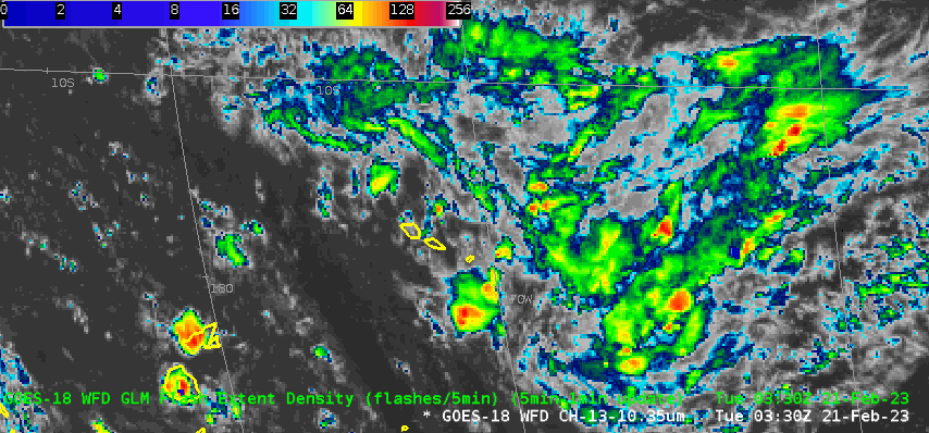
SSEC and CIMSS Scientists in the News: Scientists at the University of Wisconsin-Madison (UW) Space Science and Engineering Center (SSEC) and the Cooperative Institute for Meteorological Satellite Studies (CIMSS) provide expert interviews, imagery and case studies to promote science. This week: CIMSS Satellite Blog contributors Scott Lindstrom and Scott Bachmeier published these case studies: "Record daily snowfall in Portland Oregon" (Feb. 23), "Blowing dust in New Mexico, Texas and Oklahoma" (Feb. 22), "Long loops of Cyclone Freddy from Himawari-9 and from Polar Orbiters" (Feb. 22), "Cyclone Freddy makes landfall in Madagascar" (Feb. 21), "Heavy Rain over American Samoa" (Feb. 21), "Extensive SAR imagery over Freddy" (Feb. 20), "Kona Low flooding event in Hawai’i" (Feb. 19), "Tehuano gap wind event" (Feb. 18), "Wind feature off the mouth of the Rio Grande" (Feb. 18), and "Extended JPSS ATMS/VIIRS imagery at the CIMSS Direct Broadcast site" (Feb. 17). Read more at the CIMSS Satellite Blog: https://cimss.ssec.wisc.edu/satellite-blog/. (S. Lindstrom, CIMSS, S. Bachmeier, CIMSS, J. Phillips, SSEC, 608-262-8164)
 (Click image to enlarge)
Figure: True color RGB images from GOES-18, GOES-17 and GOES-16 showed a signature of blowing dust across parts of New Mexico, Texas and Oklahoma on Feb. 22, 2023. Read more at the CIMSS Satellite Blog: https://cimss.ssec.wisc.edu/satellite-blog/archives/50695. Credit: CIMSS, Geo2Grid, NOAA.
 (Click image to enlarge)
Figure: Flash Extent Density observations from the Geostationary Lightning Mapper (GLM) on GOES-18 showed abundant lightning with the convection around the Samoan Islands on Feb. 21, 2023. Read more at the CIMSS Satellite Blog: https://cimss.ssec.wisc.edu/satellite-blog/archives/50652. Credit: CIMSS, NOAA.
PUBLICATIONS:
Paper on Parallax Published : On February 16, a paper titled "Parallax Shift in GOES ABI Data" was published in the Journal of Operational Meteorology. The authors are: A. C. Bernal Ayala, J. J. Gerth, T. J. Schmit, S. S. Lindstrom, and J. P. Nelson III. The lead author, a student in the University of Wisconsin-Madison's Atmospheric and Oceanic department, completed much of this work during an internship with the NWS Office of Observations. Citation: A. C. Bernal Ayala, J. J. Gerth, T. J. Schmit, S. S. Lindstrom, and J. P. Nelson III, 2023: Parallax shift in GOES ABI data. J. Operational Meteor., 11 (2), 14-23, doi: https://doi.org/10.15191/nwajom.2023.1102. (T. Schmit, E/RA2, 608-263-0291, tim.j.schmit@noaa.gov)
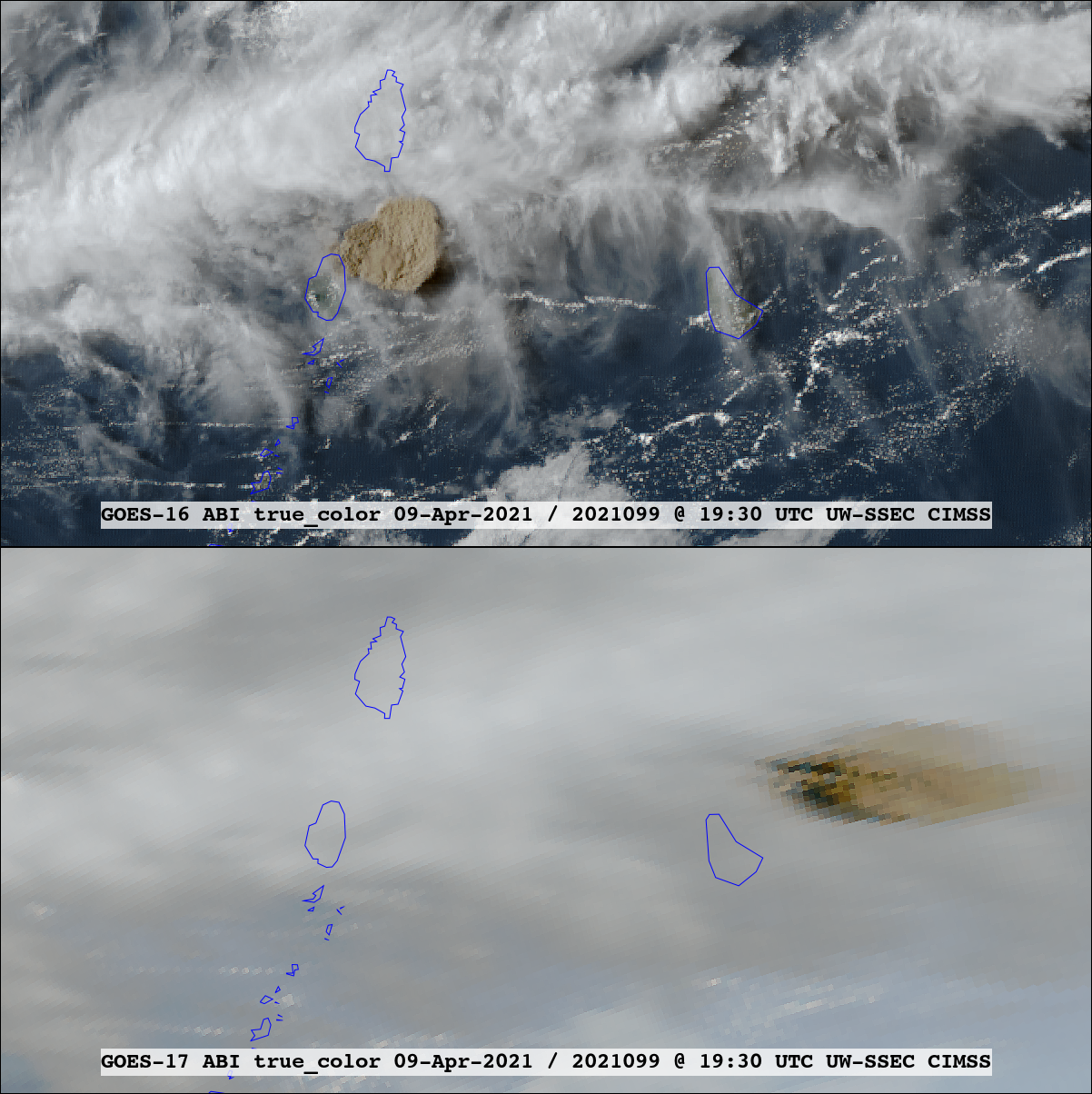 (Click image to enlarge)
Figure: True color RGB imagery from GOES-16 (top panel) and GOES-17 (lower panel) images in the same projection at 1930 UTC 9 April 2021 showing the ash cloud from the La Soufrière volcanic eruption. Note the large difference in parallax displacement from each satellite’s perspective.
Paper Describing Global Changes in Drought Characteristics Accepted for Publication: A manuscript entitled “A global transition to flash droughts under climate change” by Xing Yuan et al. has been accepted for publication in Science. J. Otkin, Cooperative Institute for Meteorological Satellite Studies (CIMSS), is a co-author of this study that used model reanalyses to examine if drought intensification rates have changed in recent decades. The results showed that droughts are intensifying more quickly over subseasonal time scales and that there has been a transition toward more flash droughts during the past six decades over most of the global IPCC SREX regions (Intergovernmental Panel on Climate Change Special Report on EXtreme events). The transition toward faster developing droughts is associated with amplified anomalies of evapotranspiration and precipitation deficits. (J. Otkin, CIMSS, 608-265-2476)
OTHER:
| Archived Weeklies Page | Submit a report item |