[ Archive ]
| CIMSS-NOAA Weekly Report [ Archive ] |
CIMSS AND ASPB WEEKLY HIGHLIGHTS FOR THE WEEK ENDING MARCH 3, 2023
DATA, INFORMATION, AND USE-INSPIRED SCIENCE:
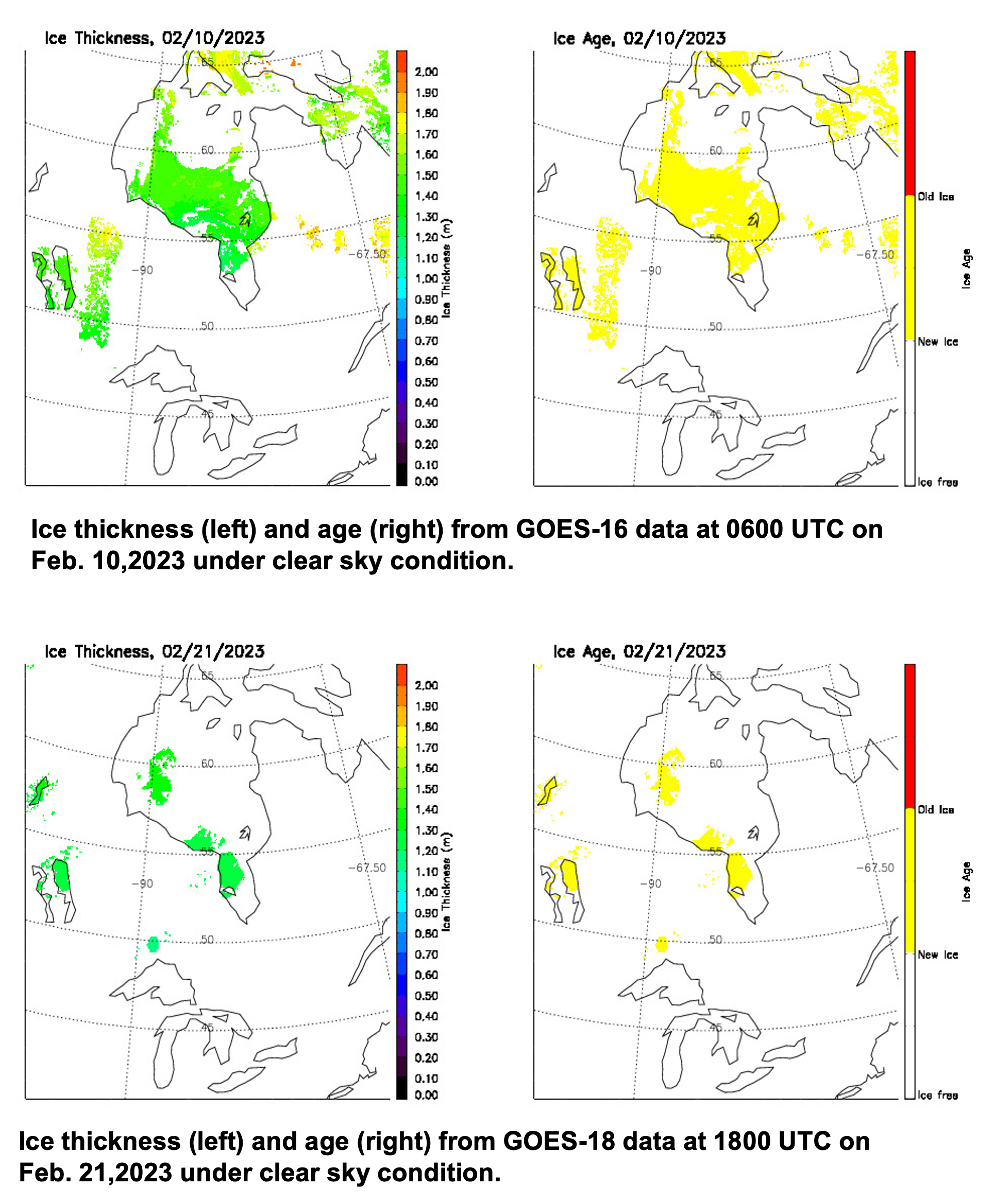
GOES-16/18 Ice Age/Thickness GEAR Review: Scientists from the University of Wisconsin-Madison Cooperative Institute for Meteorological Satellite Studies (CIMSS) and the NOAA/NESDIS/Center for Satellite Applications and Research (STAR) presented to the GOES-R Enterprise Algorithm Review (GEAR) review team the Enterprise Ice Age and Thickness products for the Advanced Baseline Imager (ABI) on GOES-16 and GOES-18. It was concluded that the products meet the mission requirements and perform as well or better than the Baseline version of the products. The Product Research to Operation (PRO) team also presented their work. Both teams showed the evidence to demonstrate that GOES-16/18 Enterprise ice age/thickness products are ready for operations. (X. Wang, CIMSS, 6082611390, Y. Liu, E/RA2, 608-8901893, J. Key, E/RA2, 608-2632605)
 (Click image to enlarge)
Figure: Ice Thickness and Age from GOES-16 (top) and GOES-18 (bottom) over Hudson Bay on two days in February 2023.
FUTURE OUTLOOK:
AWARDS AND RECOGNITION:
TRAVEL AND MEETINGS:
TRAINING AND EDUCATION:
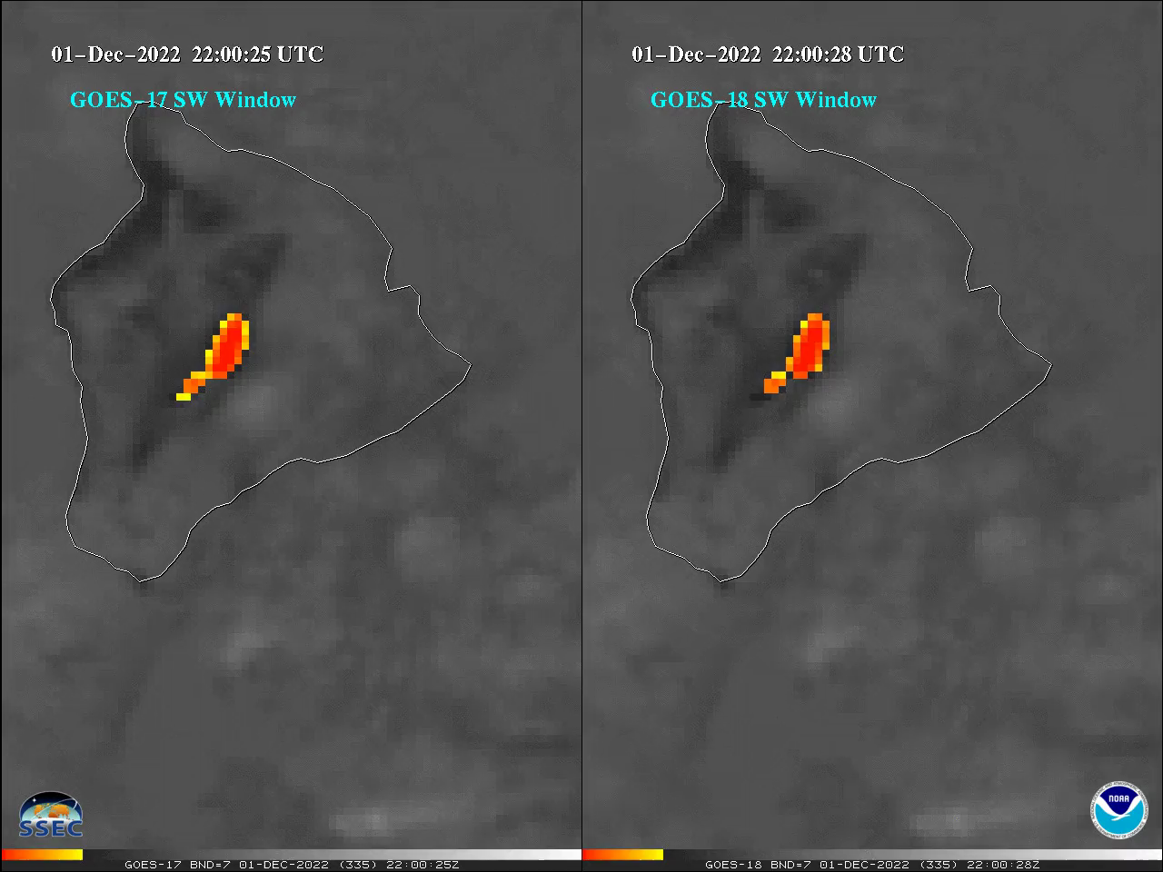
Satellite Book Club Presentation on GOES ABI: M. Gunshor, Cooperative Institute for Meteorological Satellite Studies (CIMSS), gave a presentation to the National Weather Service (NWS) Satellite Book Club (SBC) on March 2, 2023 titled, "GOES-18 versus GOES-17 ABI" (coauthors W. Line and T. Schmit of NESDIS/STAR, J. Nelson and S. Bachmeier of CIMSS). For the first time ever there were co-located geostationary imagers during the GOES-18 checkout, for approximately 6 months, and this was a unique opportunity to do satellite inter-comparisons. During this time, CIMSS measured the consistency between the two Advanced Baseline Imagers (ABI). The presentation highlighted the calibration consistency between GOES-17 and -18 ABI (at times when GOES-17 was performing well) and ended with a lively discussion including topics such as GOES-17 data quality, GOES-17 data at the 105 West longitude storage location, and how CIMSS is monitoring the GOES-18 barcode anomaly. (M. Gunshor, CIMSS, 608-263-1146, T. Schmit, E/RA2, 608-263-0291, tim.j.schmit@noaa.gov).
 (Click image to enlarge)
Figure: Mauna Loa eruption on 1 December 2022 at ~22:00 UTC, as seen by GOES-17 ABI (left) and GOES-18 ABI (right) in the 3.9um (band 7) shortwave (SW) infrared window. This still image was part of an animation that showed how similar the two satellites are and the animation can be seen in the recording of the SBC talk here: https://youtu.be/SB7HTTvIznw?t=4.
MEDIA INTERACTIONS AND REQUESTS:
SOCIAL MEDIA AND BLOG Posts:
SSEC and CIMSS Scientists in the News: Scientists at the University of Wisconsin-Madison (UW) Space Science and Engineering Center (SSEC) and the Cooperative Institute for Meteorological Satellite Studies (CIMSS) provide expert interviews, imagery and case studies to promote science. This week:
 (Click image to enlarge)
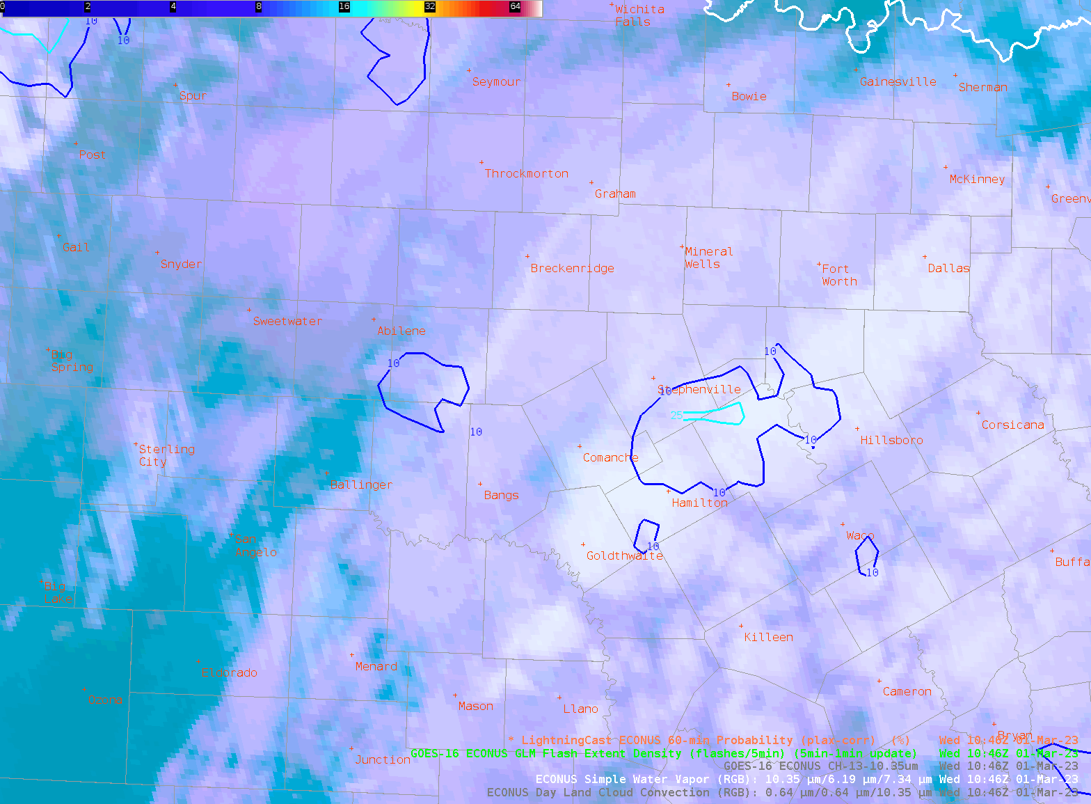
Figure: ProbSevere LightningCast, an image-based AI model, indicated rapidly growing convection in central Texas on March 1, 2023 about 15-20 minutes before lightning initiation. LightningCast predicts the probability of lightning in the next 60 minutes at any location using GOES-R ABI reflectance and brightness temperature data. Read more at the CIMSS Satellite Blog: https://cimss.ssec.wisc.edu/satellite-blog/archives/50835. Credit: CIMSS, NOAA.
PUBLICATIONS:
OTHER:
| Archived Weeklies Page | Submit a report item |