[ Archive ]
| CIMSS-NOAA Weekly Report [ Archive ] |
CIMSS AND ASPB WEEKLY HIGHLIGHTS FOR THE WEEK ENDING MARCH 17, 2023
DATA, INFORMATION, AND USE-INSPIRED SCIENCE:
FUTURE OUTLOOK:
AWARDS AND RECOGNITION:
TRAVEL AND MEETINGS:
TRAINING AND EDUCATION:
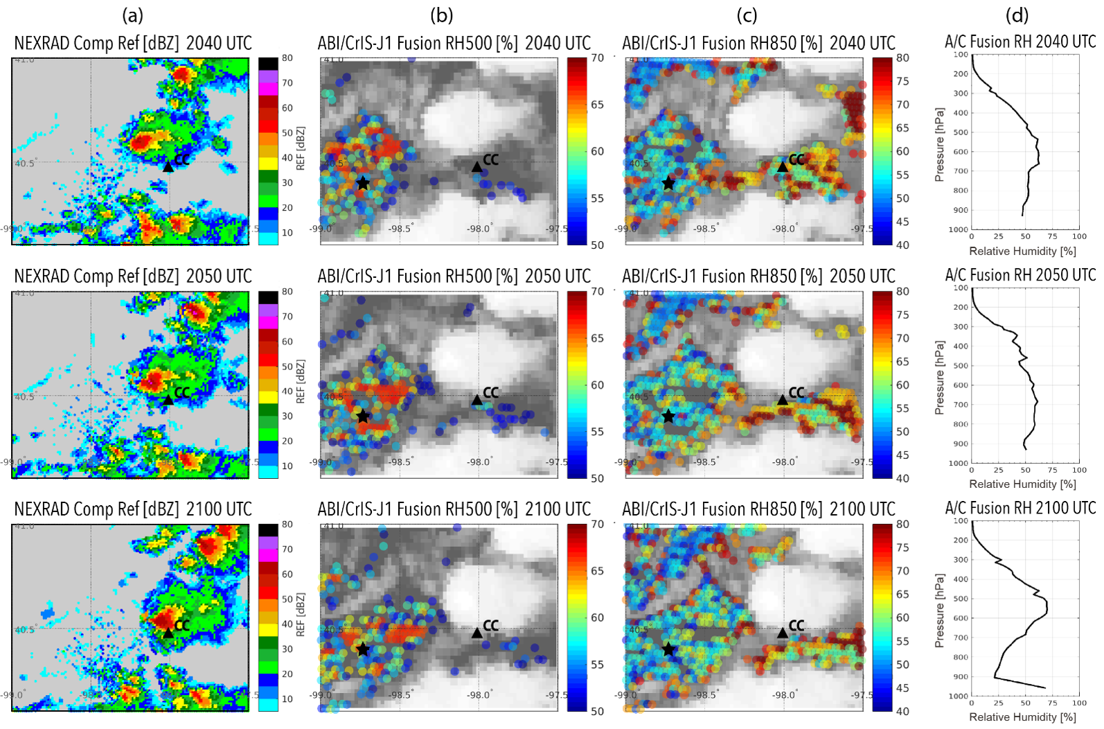
Geo Sounder Seminar at the University of Arizona in Tucson: On 15 March 2023 P. Menzel gave a seminar on “Looking forward to a GEO Hyperspectral IR Sounder - Creating LEO Sounder Products at GEO Imager Spatial and Temporal Resolution" as part of the weekly colloquium series in the Department of Hydrology and Atmospheric Sciences at the University of Arizona. The talk explained the sounder and imager data fusion process, wherein sounder products (e.g. clear sky temperature and moisture layers, atmospheric stability, and cloud top pressures) can be created at imager resolution (through spatial fusion). When connecting low earth orbiting (LEO) sounder products to time sequences of geostationary (GEO) imager radiances, a GEO sounder-like perspective of atmospheric changes in time emerges (through spatial-temporal fusion). In his talk, Dr Menzel demonstrated the spatial-temporal fusion of Cross track Infrared Sounder profile retrievals (and also Tropospheric Monitoring Instrument trace gas observations) with Advanced Baseline Imager infrared radiances (see example in figure below). This GEO/LEO fusion work is providing an early look at the remote sensing capabilities that will be routinely available with the advent of GEO hyperspectral infrared sounders (and GEO visible - near infrared spectrometers). Approximately 40 faculty and graduate students attended. Subsequent discussions with Professor Xubin Zeng and others centered on evaluating information content of infrared measurements with a fractal approach. (P. Menzel, CIMSS, 608-263-4930, paulm@ssec.wisc.edu)
 (Click image to enlarge)
Figure: Depiction of atmospheric conditions preceding a tornado in Clay Center at 2130 UTC. (a) Regional NEXRAD composite reflectivity; (b) ABI/CrIS fusion RH [%] at 500 hPa; (c) ABI/CrIS fusion RH [%] at 850 hPa; and (d) ABI/CrIS fusion RH profiles for the location marked by a black asterisk in panels (b,c), about 60 km west of Clay Center (CC) at 2040 UTC (top row), 2050 UTC (middle row), and 2100 UTC (bottom row) on 5 May 2021. (From Weisz and Menzel, doi.org/10.3390/rs14215327)
CIMSS Presentation for ECCC Stay Connected Seminar Series: Scott Lindstrom from the Cooperative Institute for Meteorological Satellite Studies (CIMSS) gave a presentation as part of the Stay Connected Seminar Series through the Training Development Division of Environment and Climate Change Canada (ECCC). The talk showed GOES Satellite Imagery for some of the top weather-related events that affected Canada in 2022, as listed here https://www.canada.ca/en/environment-climate-change/services/top-ten-weather-stories/2022.html. The talk also included the latest information on the GeoXO satellite system planned for the 2030s and beyond. About 60 people were dialed into the webinar. The PowerPoint is available here: https://cimss.ssec.wisc.edu/training/PowerPoints/Lindstrom_ECCC_GOES_views_Canada_2023.pptx. (S. Lindstrom, CIMSS, 608 263 4425)
MEDIA INTERACTIONS AND REQUESTS:
SOCIAL MEDIA AND BLOG Posts:
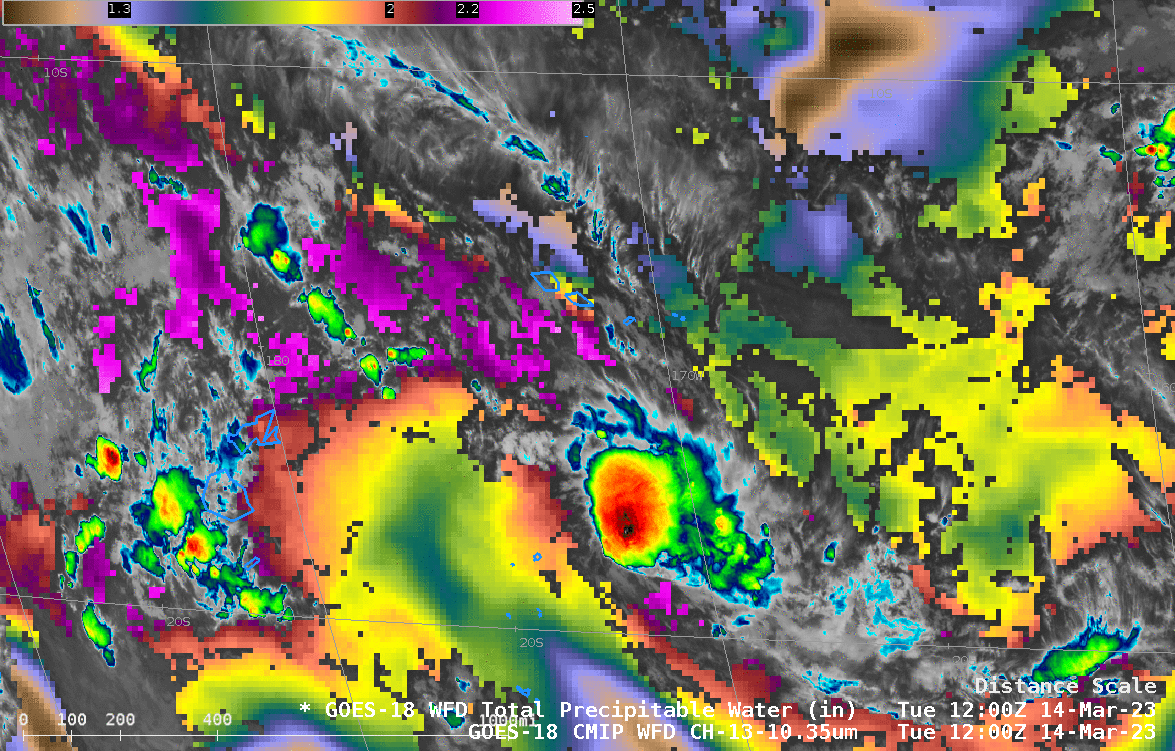
SSEC and CIMSS Scientists in the News: Scientists at the University of Wisconsin-Madison (UW) Space Science and Engineering Center (SSEC) and the Cooperative Institute for Meteorological Satellite Studies (CIMSS) provide expert interviews, imagery and case studies to promote science. This week: CIMSS Satellite Blog contributors Scott Lindstrom and Scott Bachmeier published these case studies: "Standing waves downwind of Oahu" (March 15), "Late season Nor’easter" (March 14), "Using Polar2Grid (version 3.0) to create single-channel VIIRS images from NOAA CLASS data" (March 14), "Tropical Invest 91P south of American Samoa" (March 14), "SAR wind observations near Samoa on 13 March" (March 13), and "Severe thunderstorms in the Central Valley of California" (March 11). Read more at the CIMSS Satellite Blog: https://cimss.ssec.wisc.edu/satellite-blog/. (S. Bachmeier, CIMSS, S. Lindstrom, CIMSS, J. Phillips, SSEC)
(Click image to enlarge)
Figure: GOES-16 Air Mass RGB images with surface analyses of pressure and fronts showed the progression of a late-season Nor’easter, March 13-15, 2023. The storm produced heavy snowfall across much of the Northeast US. Read more at the CIMSS Satellite Blog: https://cimss.ssec.wisc.edu/satellite-blog/archives/51098. Credit: CIMSS, NOAA.
 (Click image to enlarge)
Figure: GOES-18 infrared imagery and derived Total Precipitable Water, showed Tropical Invest 91P several hundred miles south of American Samoa within a corridor of moisture associated with the South Pacific Convergence Zone (SPCZ). Read more at the CIMSS Satellite Blog: https://cimss.ssec.wisc.edu/satellite-blog/archives/51088. Credit: CIMSS, NOAA.
PUBLICATIONS:
OTHER:
| Archived Weeklies Page | Submit a report item |