[ Archive ]
| CIMSS-NOAA Weekly Report [ Archive ] |
CIMSS AND ASPB WEEKLY HIGHLIGHTS FOR THE WEEK ENDING APRIL 7, 2023
DATA, INFORMATION, AND USE-INSPIRED SCIENCE:
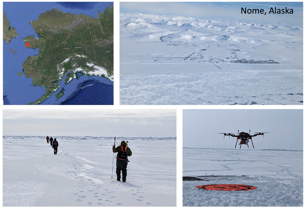
UAS and Surface Measurements Over Sea Ice at Nome, Alaska: Four STAR scientists participated in the second phase of the UAS (Uncrewed Aircraft System) Sea Ice Retrieval for Calibration/Validation Experiment (USIR-CV EX) on the sea ice at Nome, Alaska, March 27 – March 31, 2023: Jeff Key, Yinghui Liu, Sean Helfrich, and Larry Connor. For the STAR scientists, the goal was to collect a robust dataset for validation of AMSR2 sea ice thickness and VIIRS sea ice products. This fieldwork was a follow-on to similar work done in the Straits of Mackinac, Michigan, in February 2022. The Michigan experiment was a pilot study to test UAS cold-weather capabilities and coordinate surface, UAS, and satellite observations. At Nome, surface measurements of sea ice thickness, snow properties (depth, weight/volume, and grain size), and basic meteorology were made while the UAS and satellites were overhead. Most of the surface observations were made over relatively level shore-fast ice, with some of the measurements taken over the more dynamically formed ice further from the shore that was characterized by rubble and ridges. The UAS used at Nome (Harris H6) was a larger and more capable vehicle than the one used in Mackinaw (M600 Matrix Pro). Both vehicles carried a Tetracam Macaw+Tau six-band visible/near-IR plus one thermal IR band imager and multiple GoPro cameras for context. The Nome aircraft also carried a Thermal Imager (FLIR Vue PRO) and Atmospheric Sensor (InterMet Systems). Integration, testing, data collection, planning/execution, and piloting of the platform and payload were supported by GeoThinkTank LLC and the University of Maryland UAS Research and Operations Center (UROC). On March 31, Key, Helfrich, and Liu traveled to Anchorage to meet with Scott Lindsey, Director of NWS Alaska Region. The following day the team visited the NWS Alaska Sea Ice Program (ASIP) ice analysts at their Sand Lake office and had in-depth discussions on their operations and use of satellite imagery and products. (J. Key, E/RA2, 608-263-2605, jeff.key@noaa.gov; Y. Liu, E/RA2, 608-890-1893, yinghui.liu@noaa.gov; S. Helfrich, sean.helfrich@noaa.gov; L. Connor, laurence.connor@noaa.gov)
 (Click image to enlarge)
Figure: Collage of pictures from Nome. Additional pictures are available at https://photos.app.goo.gl/ruN1APSvcNRj9cSY8.
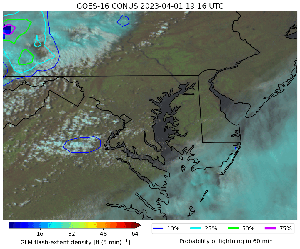
CIMSS supports NWS for LightingCast case study: John Cintineo of the Cooperative Institute for Meteorological Satellite Studies (CIMSS), at the request of Luis Rosa of the National Weather Service (NWS) in Sterling, VA, created an animation illustrating the development of a squall line as observed by GOES-16 ABI data in the Mid-Atlantic. Mr. Rosa plans to use this case to illustrate LightningCast's utility at a local severe weather workshop. ProbSevere LightningCast is an image-based machine-learning model that predicts next-hour probabilities of lightning using GOES-R ABI images. The animation showed the evolution of LightingCast probabilities along the developing line, which produced numerous severe weather reports in the region. (J. Cintineo, CIMSS, cintineo@wisc.edu; M. Pavolonis, NOAA/NESDIS/STAR, michael.pavolonis@noaa.gov)
 (Click image to enlarge)
Figure: Evolution of a squall line in the Mid-Atlantic, as observed by GOES-16 ABI. Background is GOES-16 Day-Land-Cloud RGB; contours are probabilities of next-hour lightning from ProbSevere LightningCast (blue=10%, cyan=25%, green=50%, magenta=75%); blue-to-maroon pixels are GOES-16 GLM flash-extent density observations.
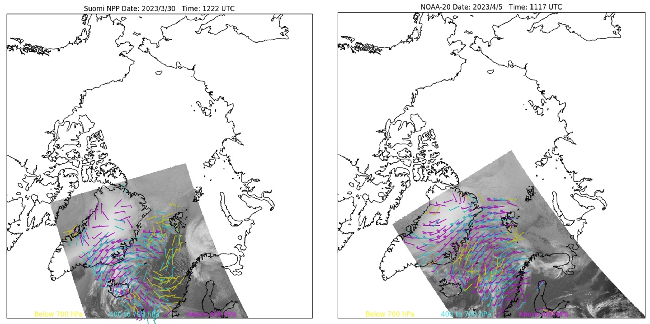
VIIRS Polar Winds from Sodankylä, Finland Direct Broadcast Data: As of 30 March 2023, S-NPP and NOAA-20 VIIRS polar winds are being generated in near-real time from direct broadcast (DB) data acquired at Sodankylä, Finland. The winds are produced using the Enterprise winds algorithm. Some years ago, VIIRS and MODIS winds were generated on site at Soldankylä using a computer supplied by the Cooperative Institute for Meteorological Satellite Studies (CIMSS)/Space Science and Engineering Center (SSEC) in 2007. That computer reached the end of its life and was not replaced. In recent years the Internet bandwidth from Soldankylä improved substantially, so it is now feasible to bring the VIIRS data to CIMSS and generate the wind data there. Polar wind production at the University of Alaska-Fairbanks has a similar history, and the same procedure has been employed for the past few years. The benefit of the DB winds is that they are available in about half the time compared to the operational wind products. Therefore, more wind data can be assimilated in model analyses and have a larger impact on forecasts. Examples of VIIRS polar winds over the Scandinavian region from Soldankylä direct broadcast data are shown in the figure below. (R. Dworak, CIMSS, 608-265-8620; J. Key, E/RA2, 608-263-2605, jeff.key@noaa.gov; D. Santek, CIMSS, 608-263-7410)
 (Click image to enlarge)
Figure: Examples of direct broadcast VIIRS polar winds from NPP (left) at 12:22 UTC on 30 March 2023 and NOAA-20 (right) 11:17 UTC on 04 April 2023.
FUTURE OUTLOOK:
AWARDS AND RECOGNITION:
TRAVEL AND MEETINGS:
Presentation at the Joint Typhoon Warning Center Tropical Cyclone Conference: Current and In-progress products from the Cooperative Institute for Meteorological Satellite Studies (CIMSS) Tropical Cyclone (TC) group were presented at the annual Tropical Cyclone Conference hosted by the Joint Typhoon Warning Center (JTWC) by Sarah Griffin in Honolulu, HI. These products included the new machine learning based products to estimate current TC intensity, including Advanced (AI-enhanced) Dvorak Technique (AiDT), as well as Deep Multi INTensity (D-MINT) and DeeP IR INTensity (D-PRINT) and future products to estimate the 2-dimensional TC wind field and short-term TC intensity. After attending the conference, Sarah was able to spend a day visiting JTWC. While there, she received a briefing on how forecasters used the current intensity products in day-to-day operations. In addition, she was able to talk with forecasters about areas where they would like to see additional products. (Sarah Griffin, CIMSS)
TRAINING AND EDUCATION:
MEDIA INTERACTIONS AND REQUESTS:
SOCIAL MEDIA AND BLOG Posts:
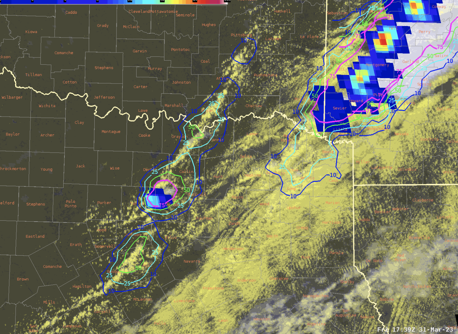
SSEC and CIMSS Scientists in the News: Scientists at the University of Wisconsin-Madison (UW) Space Science and Engineering Center (SSEC) and the Cooperative Institute for Meteorological Satellite Studies (CIMSS) provide expert interviews, imagery and case studies to promote science. This week: CIMSS Satellite Blog contributors Scott Lindstrom, Elisabeth Weisz, Scott Bachmeier and John Cintineo published these case studies: "Recent results from a numerical model input with Polar Hyperspectral Soundings fused with ABI data (Convective Weather edition)" (April 6), "An airmass change at Guam" (April 6), "Using Data Fusion to create 5.15 micrometer imagery" (April 5), "Severe thunderstorms across Iowa and Illinois" (April 4), "Accessing and displaying historical ATMS imagery and products with Polar2Grid (version 3.0)" (April 4), "SAR Winds around Kaua’i" (April 4), "49th anniversary of the 1974 Super Outbreak" (April 3), "Widespread outbreak of severe thunderstorms across the Midwest and South" (March 31), "Predicting lightning initiation with AI" (March 31), "Using Level 2 Products to anticipate convective development in the south Pacific ocean" (March 31), and "Bore features in the Day Night Band over Minnesota and Iowa" (March 31). Read more at the CIMSS Satellite Blog: https://cimss.ssec.wisc.edu/satellite-blog/. (S. Lindstrom, CIMSS, E. Weisz, CIMSS, S. Bachmeier, CIMSS, J. Cintineo, CIMSS, J. Phillips, SSEC, 608-262-8164)
 (Click image to enlarge)
Figure: GOES-16 mesoscale sector with Day-Cloud-Convection RGB from ABI (background), GOES-16 GLM flash-extent density (blue-to-orange pixels), and LightningCast probabilities of lightning in the next 60 min (blue=10%; cyan=25%; green=50%; magenta=75%) over Texas on March 23, 2023. Read more at the CIMSS Satellite Blog: https://cimss.ssec.wisc.edu/satellite-blog/archives/51431. Credit: CIMSS, NOAA.
PUBLICATIONS:
OTHER:
| Archived Weeklies Page | Submit a report item |