[ Archive ]
| CIMSS-NOAA Weekly Report [ Archive ] |
CIMSS AND ASPB WEEKLY HIGHLIGHTS FOR THE WEEK ENDING APRIL 14, 2023
DATA, INFORMATION, AND USE-INSPIRED SCIENCE:
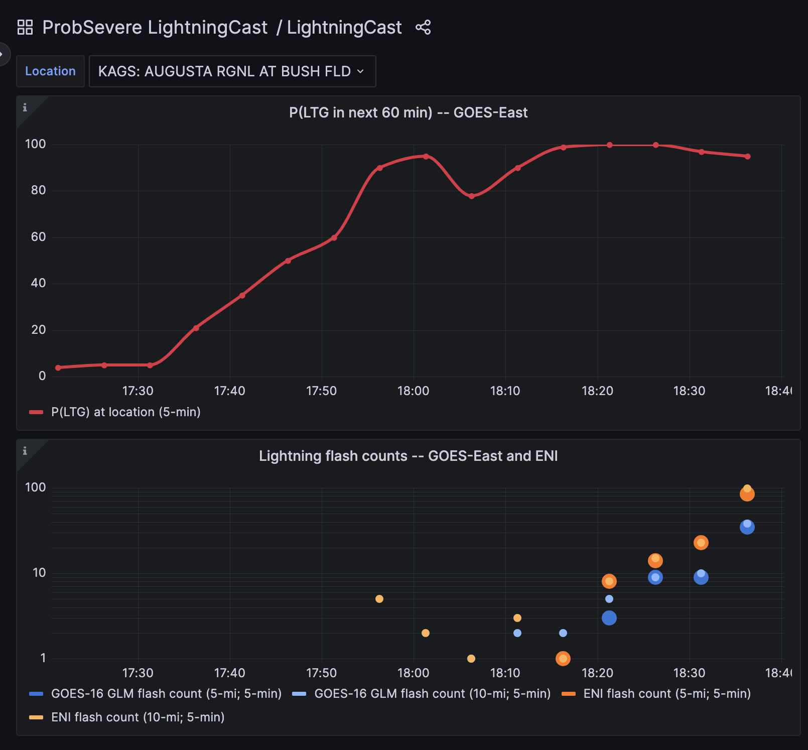
New Interface for LightningCast AI Model: The ProbSevere team at the Cooperative Institute for Meteorological Satellite Studies (CIMSS) created a new LightningCast model interface to help forecasters monitor the time tendency of lightning potential at airports. This unique new interactive capability is described in a CIMSS blog post. The new interface was developed in response to feedback from forecasters. LightningCast is currently used by NWS forecasters (in AWIPS), and at air traffic control centers, via an experimental feed. Work to transition LightningCast to NESDIS operations will likely commence later this year. LightningCast is a deep-learning AI model that transforms GOES-R ABI imagery into forecasts of where the GLM will observe lightning up to 60 minutes in the future. Thus, this is a good example of using AI to further increase the value of satellite imagery through automated extraction of human expert-like insights. (J. Cintineo, CIMSS john.cintineo@ssec.wisc.edu; J. Sieglaff, CIMSS, justin.sieglaff@ssec.wisc.edu; Michael Pavolonis, NOAA/NESDIS/STAR, michael.pavolonis@noaa.gov)
 (Click image to enlarge)
Figure: Time series of LightningCast's next-hour probability of lightning and observed lightning flashes from GLM and ground-based networks. The location is the airport in Augusta, GA, and the time was the afternoon of April 7, when lightning was threatening the nearby Master's Golf Tournament, a major sporting event with tens of thousands of spectators.
FUTURE OUTLOOK:
AWARDS AND RECOGNITION:
TRAVEL AND MEETINGS:
TRAINING AND EDUCATION:
Satellite Training Telecons at WFO Guam: Scott Lindstrom from the Cooperative Institute for Meteorological Satellite Studies (CIMSS) has started a series of regularly-scheduled every-other-week telecons to WFO Guam. The purpose of the telecons is to advocate for the use of Satellite Imagery in the Decision Making and Situational Awareness, and to learn how satellite data are being used in the Guam forecast office. This telecon series is similar to the ongoing weekly telecons between CIMSS and the forecast office in Pago Pago. The products discussed this week included Scatterometry, MIMIC Total Precipitable Water and SAR Winds. Special attention was given to Invest 90W that is moving into the Philippines. (Scott Lindstrom, CIMSS, 608 263 4425)
CIMSS VISIT Training on GOES-R IFR Probability: Scott Lindstrom from the Cooperative Institute for Meteorological Satellite Studies (CIMSS) gave a Virtual Institute for Satellite Integration Training (VISIT) presentation to a forecaster from WFO Pittsburgh (WFO PBZ) on GOES-R Instrument Flight Rules (IFR) Probability, the GOES-R Level-2 product for Fog Detection. Particular emphasis was given to detection of fog in narrow river valleys. (S. Lindstrom, CIMSS, 608 263 4425)
MEDIA INTERACTIONS AND REQUESTS:
SOCIAL MEDIA AND BLOG Posts:
SSEC and CIMSS Scientists in the News: Scientists at the University of Wisconsin-Madison (UW) Space Science and Engineering Center (SSEC) and the Cooperative Institute for Meteorological Satellite Studies (CIMSS) provide expert interviews, imagery and case studies to promote science. This week: CIMSS Satellite Blog contributors Scott Bachmeier, Scott Lindstrom and John Cintineo published these case studies: "Cyclone Ilsa makes landfall in Australia" (April 13), "VIIRS True-Color Imagery over the Clear Great Lakes" (April 12), "Indiana recycling plant fire" (April 11), "Sentinel-1A SAR Observations over Hawai’i late on 10 April" (April 11), "Eruption of Bezymianny on Kamchatka" (April 7), "A new tool for monitoring lightning" (April 7) and "Satellite signatures of the Intelsat IS-40e / TEMPO Mission launch" (April 7). Read more at the CIMSS Satellite Blog: https://cimss.ssec.wisc.edu/satellite-blog. (S. Bachmeier, CIMSS, S. Lindstrom, CIMSS, J. Cintineo, CIMSS, J. Phillips, SSEC, 608-262-8164)
 (Click image to enlarge)
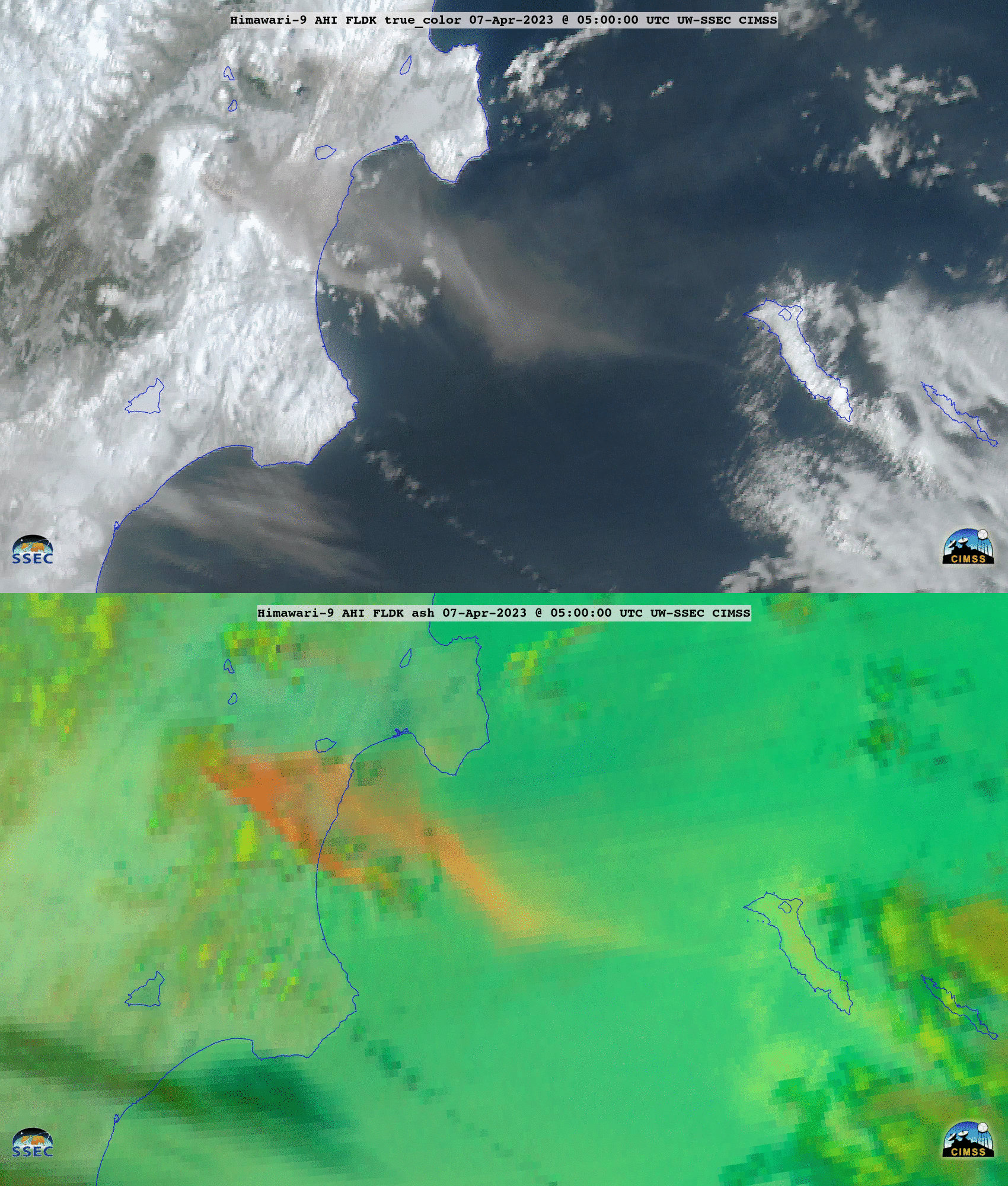
Figure: JMA Himawari-9 true color RGB and ash RGB images provided a closer view of the volcanic cloud produced by the eruption of Bezymianny Volcano on the Kamchatka Peninsula of Russia on April 6-7, 2023. Read more at the CIMSS Satellite Blog: https://cimss.ssec.wisc.edu/satellite-blog/archives/51596. Credit: JMA, CIMSS.
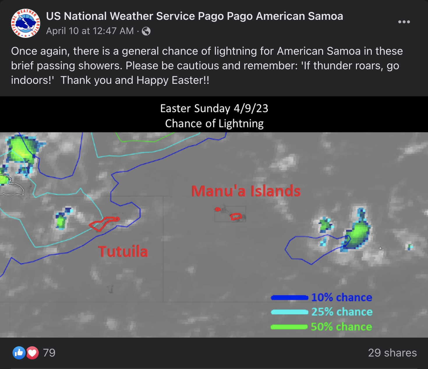
NWS in American Samoa use LightningCast data in social media graphic: The Cooperative Institute for Meteorological Satellite Studies (CIMSS) continues to support NWS Pago Pago, American Samoa, with ProbSevere LightningCast data. LightningCast is an artificial-intelligence model that uses images of GOES-R Advanced Baseline Imager (ABI) data to create next-hour probabilistic predictions of lightning. The NWS in Pago Pago can view the LightningCast output through a website, currently. This week, the office showed an image of LightningCast's probability of lightning contours around American Samoa, highlighting showers with a chance of lightning. Also this week, personnel at CIMSS assisted forecasters in NWS Pago Pago by providing animations of images with LightningCast, ABI, and GLM (Geostationary Lightning Mapper) data displayed, for use in a conference presentation. (J. Cintineo, CIMSS, cintineo@wisc.edu; J. Sieglaff, CIMSS, justin.sieglaff@ssec.wisc.edu; S. Lindstrom, CIMSS, scottl@ssec.wisc.edu; M. Pavolonis, NOAA/NESDIS/STAR, michael.pavolonis@noaa.gov).
 (Click image to enlarge)
PUBLICATIONS:
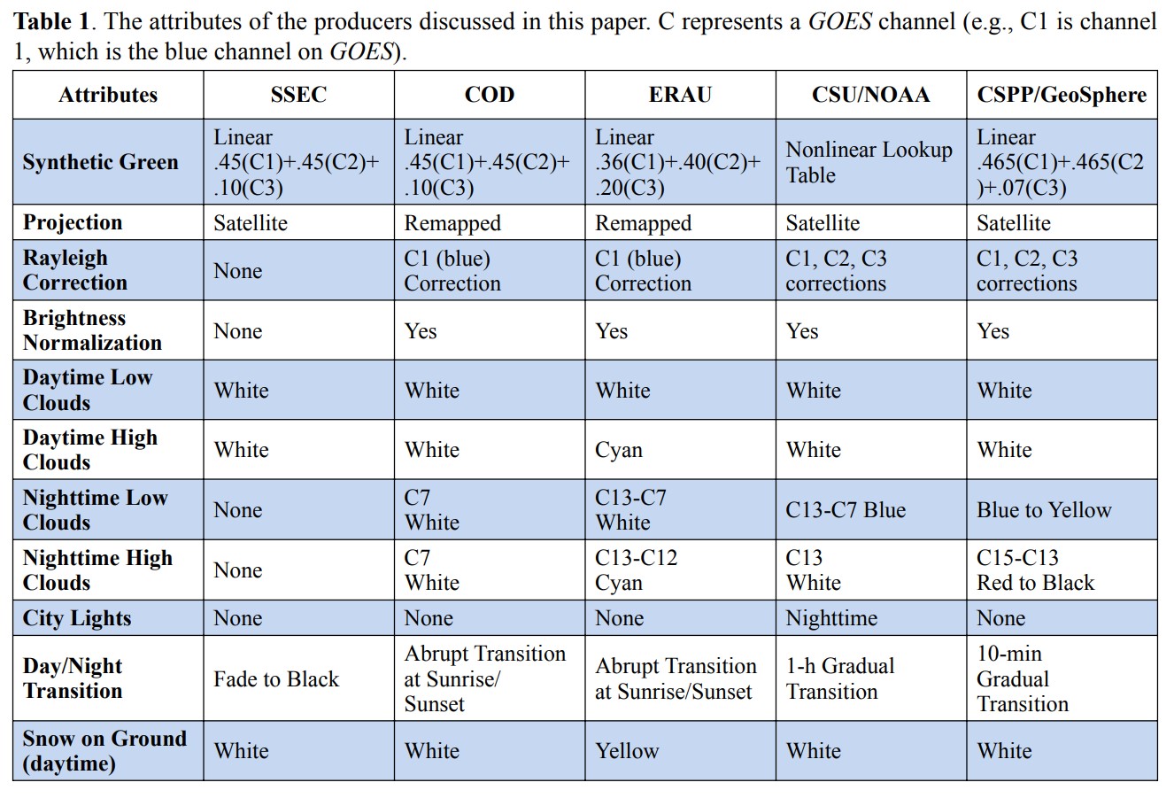
Paper Published on True-Color Imagery: A paper was published in the National Weather Association (NWA) Journal of Operational Meteorology on GOES (Geostationary Operational Environmental Satellite) true-color imagery. The paper compares various versions of GOES true-color imagery available on the web, including the GOES Viewer (https://www.star.nesdis.noaa.gov/GOES/index.php). Citation: Mosher, F. R., and Coauthors, 2023: True-color imagery from GOES—A synopsis of past and present. J. Operational Meteor., 11 (4), 33–48, doi: https://doi.org/10.15191/nwajom.2023.1104. (T. Schmit, E/RA2, 608-263-0291, tim.j.schmit@noaa.gov; J. P. Nelson, CIMSS)
 (Click image to enlarge)
Figure: Table 1 of Mosher et al., comparing some of the versions of GOES true-color imagery available on the web.
OTHER:
| Archived Weeklies Page | Submit a report item |