[ Archive ]
| CIMSS-NOAA Weekly Report [ Archive ] |
CIMSS AND ASPB WEEKLY HIGHLIGHTS FOR THE WEEK ENDING MAY 12, 2023
DATA, INFORMATION, AND USE-INSPIRED SCIENCE:
FUTURE OUTLOOK:
AWARDS AND RECOGNITION:
TRAVEL AND MEETINGS:
TRAINING AND EDUCATION:
Training by CIMSS at the Honolulu NWS Forecast Office: Scott Lindstrom from the Cooperative Institute for Meteorological Satellite Studies was at the National Weather Service forecast in Honolulu Hawaii from 9-11 May 2023 to give training to the forecast staff. This in-person training (the first since before COVID) was designed to remind forecasters of the use of various satellite products that can be critical to diagnosing the state of the atmosphere over the Pacific Ocean where other data sources are very sparse. These in-person training events also strengthen the relationship between trainers and NWS forecasters; that relationship fosters exchanges of information that streamlines the adoption of satellite products in the forecast workflow. Topics covered included CIMSS Turbulence Probability fields, ProbSevere LightningCast probabilities, NOAA-Unique Combined Atmospheric Processing System (NUCAPS) vertical profiles and gridded products, Microwave Data (very important at Hawaii given their Direct Broadcast capabilities), and satellite-derived winds (both DMWs from GOES-18 and Scatterometry/SAR winds). Training was supplied to about a dozen forecasters, less than half the staff, but the sessions were recorded for the use of forecasters on leave or on overnight shifts. The training was funded by the JPSS Office and was done at the request of NWS Pacific Region (S. Lindstrom, CIMSS, 608 263 4425)
 (Click image to enlarge)
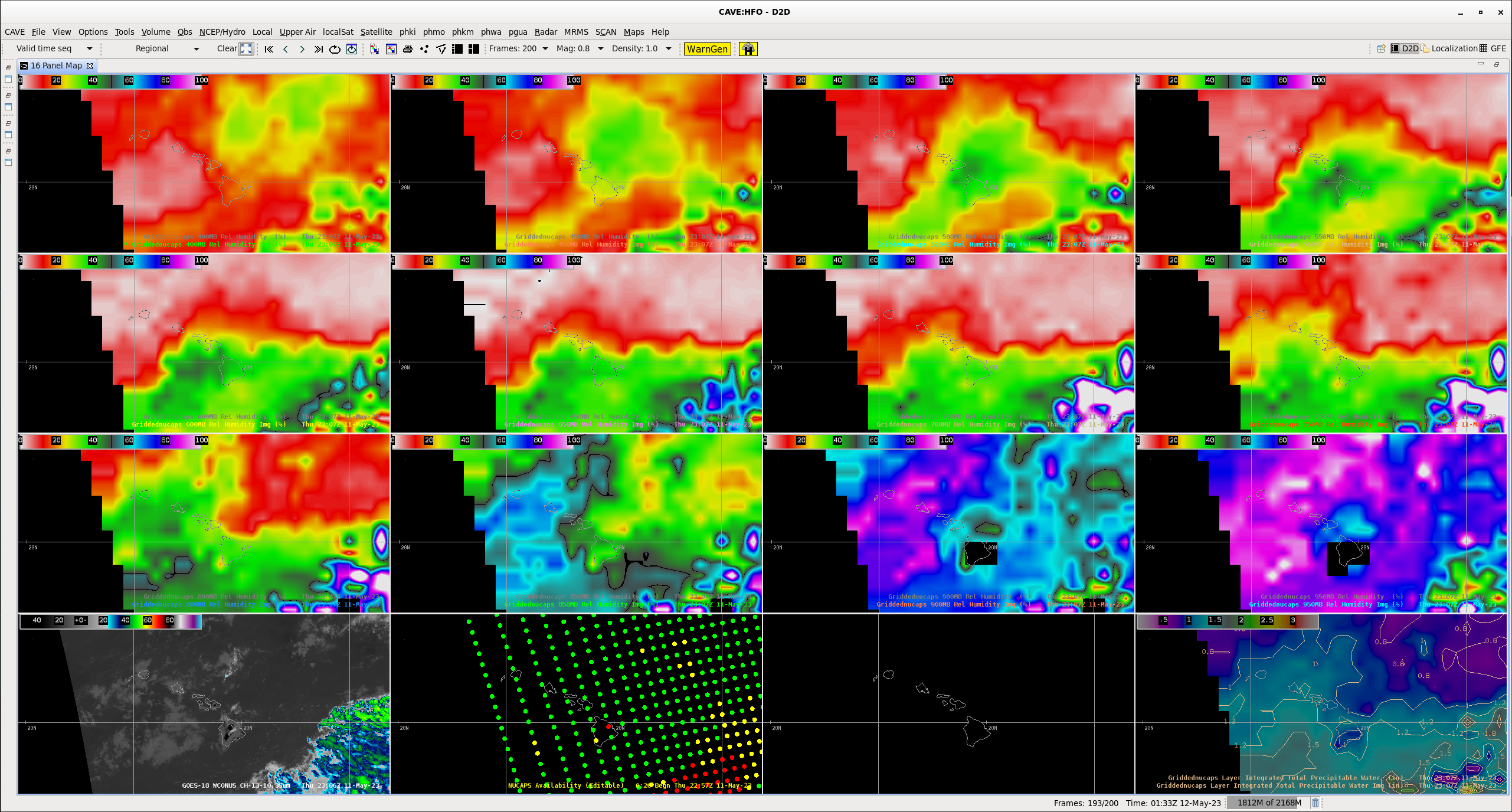
Figure: Gridded NUCAPS fields (ca. 1200 UTC on 11 May 2023) of relative humidity at 50 mb intervals from 400 mb to 550 mb (Top Row, left to right), 600 to 750 mb (row 2, left to right), 800 to 950 mb (row 3, left to right), along with GOES-18 PACUS field of Band 18 (bottom 4, left), NUCAPS Sounding Availability points (bottom 4, column 2) and NUCAPS Total Precipitable Water. Image Procedure created by and courtesy off NWS HFO Science and Operations Office Bob Ballard.
MEDIA INTERACTIONS AND REQUESTS:
SOCIAL MEDIA AND BLOG Posts:
SSEC and CIMSS Scientists in the News: Scientists at the University of Wisconsin-Madison (UW) Space Science and Engineering Center (SSEC) and the Cooperative Institute for Meteorological Satellite Studies (CIMSS) provide expert interviews, imagery and case studies to promote science. This week: CIMSS and SSEC scientists John Cintineo and Alexa Ross, along with CIMSS Satellite Blog contributors Scott Lindstrom and Scott Bachmeier published these case studies: "Tropical Storm Mocha in the Bay of Bengal" (May 11, 2023), "Lightning at the Flying Pig Marathon" (May 08, 2023), "Severe thunderstorms in Missouri and Nebraska" (May 06, 2023) "Gap Winds west of the Hawai’ian Islands" (May 05, 2023). Read more at the CIMSS Satellite Blog: https://cimss.ssec.wisc.edu/satellite-blog/. (S. Lindstrom, CIMSS, S. Bachmeier, CIMSS, J. Cintineo, CIMSS, 608-890-0619, A. Ross, CIMSS, 608-263-6765, E. Verbeten, SSEC.)
 (Click image to enlarge)
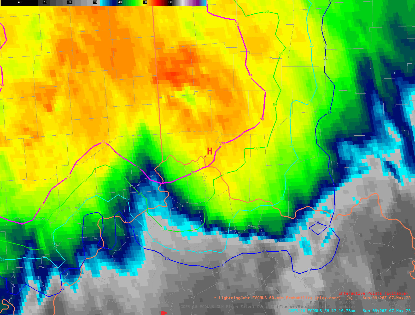
Figure: LightningCast probability contours (blue=10%, cyan=25%, green=50%; magenta=75%) and GOES-16 10.3 µm brightness temperature, prior to the and during the first 50 minutes of the race. The point marked “H” is Cincinnati Municipal Airport — Lunken Field, which is just a few miles east of downtown Cincinnati, the location of the marathon route.
PUBLICATIONS:
OTHER:
| Archived Weeklies Page | Submit a report item |