[ Archive ]
| CIMSS-NOAA Weekly Report [ Archive ] |
CIMSS AND ASPB WEEKLY HIGHLIGHTS FOR THE WEEK ENDING MAY 19, 2023
DATA, INFORMATION, AND USE-INSPIRED SCIENCE:
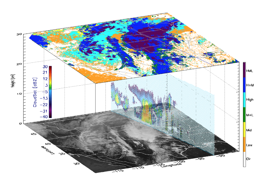
GOES-18 Cloud Cover Layers Provisional Maturity Review: STAR Cloud Science Team members comprised of scientists from Colorado State University’s Cooperative Institute for Research in the Atmosphere (CIRA), the University of Wisconsin-Madison Cooperative Institute for Meteorological Satellite Studies (CIMSS), and STAR provided a GOES-18 Cloud Cover Layers (CCL) product evaluation at a Provisional Peer/Stakeholder - Product Validation Review (PS-PVR) held on 16 May 2023. The PS-PVR assessed the state of the CCL product and its suitability for operational use. GOES-18 CCL products period were generated by the Algorithm Scientific Software Integration and System Transition Team (ASSISTT) on the NESDIS/STAR Algorithm Processing Framework (SAPF or “Framework”) and by the GOES-R Product Readiness and Operations (PRO) Team on the Development Environment (DE) of the operational Ground System (GS). A retrospective GOES-16 dataset was also created by ASSISTT to accommodate comparisons to CALIPSO and CloudSat spaceborne lidar and radar observations. Quantitative comparisons against CloudSat, CALIPSO, and Department of Energy Atmospheric Radiation Measurement ground-based active sensors all indicated that CCL accuracy values exceeded the 60% threshold needed to reach Provisional Maturity status. The only issue noted by the team's visual analysis was a GOES-18 CCL striping artifact that was located in the Southern Hemisphere. This artifact was limited to DE-generated CCL Full Disk products. Based on the quantitative validation analyses, the GOES-18 CCL product passed its Provisional Maturity Review. An Algorithm Discrepancy Report will be created to rectify the DE CCL product striping issue. (M. Kulie, E/RA2, 608-263-6583, mark.kulie@noaa.gov)
 (Click image to enlarge)
Figure: A GOES Advanced Baseline Imager (ABI) scene overlaid with a CloudSat radar profile and Cloud Cover Layers (CCL) product. CloudSat was used as a primary validation dataset in the recent CCL Provisional Maturity Review.
 (Click image to enlarge)
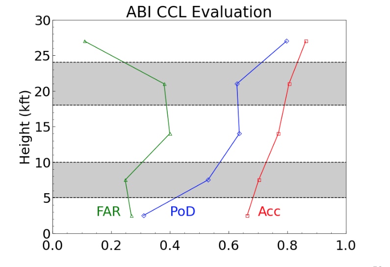
Figure: CCL accuracy (Acc; red), probability of detection (PoD; blue), and false alarm ratio (FAR; green) statistics when compared against co-located CloudSat observations. Note that CCL accuracy exceeds the 60% validation threshold for all five flight layers.
FUTURE OUTLOOK:
AWARDS AND RECOGNITION:
TRAVEL AND MEETINGS:
CIMSS Participation in the IWW16: The 16th International Winds Workshop was held in Montreal, Canada from 8-12 May 2023. The biennial International Winds Workshops are the forums used by the International Winds Working Group (IWWG) for cooperation in the operational and research community, and have strongly contributed to the improvement in quality of the derived wind fields and their use in Numerical Weather Prediction (NWP). Steve Wanzong, Cooperative Institute for Meteorological Satellite Studies (CIMSS), worked with the local organizers, Environment and Climate Change Canada (ECCC) and the Université du Québec à Montréal (UQAM), for the overall logistics and content of the meeting. Dave Santek led a Plenary discussion on the 4th Atmospheric Motion Vector (AMV) Intercomparison study. Rich Dworak presented his work titled "Experimental VIIRS AMV Products: Expanding Beyond the use of a Single Satellite", remotely. The IWW16 completes Steve Wanzong's term as a co-chair of the IWWG and as a representative of the Coordination Group for Meteorological Satellites (CGMS) Working Group II. CIMSS will continue to provide the email and web support for the IWWG. (S. Wanzong, CIMSS, 608-265-5355, D Santek, CIMSS, 608-263-7410, R. Dworak, CIMSS, 608-265-8620).
WMO Meetings on Cryosphere Observing Requirements: Over the past few years the World Meteorological Organization (WMO) has been developing high-level guidance on the evolution of the observing system. Part of that effort is an assessment of observational requirements (needs), capabilities, and gaps. Recommendations for filling those gaps are to be presented in a Statement of Guidance for each of WMO's six Earth System Application Categories (ESAC). Jeff Key (STAR) is the Coordinator for the Cryosphere ESAC, and leads a team for the WMO Global Cryosphere Watch (GCW) that will create a Cryosphere Statement of Guidance. He recently participated in two meetings relevant to this task. On May 9, he participated remotely in a collaborative meeting with the WMO Expert Team on Met-Ocean Requirements (ET-MOR), given that both teams are concerned with sea ice requirements. On May 17, he participated remotely in the WMO First Rolling Review of Requirements (RRR) workshop, which brought together the Coordinators for the six ESACs and the Points of Contact for the Application Areas within each ESAC. (J. Key, E/RA2, 608-263-2605, jeff.key@noaa.gov)
TRAINING AND EDUCATION:
G6-12 JPSS VIIRS VIIRS Virtual Science Fair Top Projects Announced: The second annual JPSS VIIRS Virtual Science Fair for Grades 6-12 has concluded and the top projects were announced this week. A high school student from New Jersey earned a perfect score in a solo project on "Forecasting Rapid Intensification of Hurricanes" and a team of 2 middle school students from Virginia took first place with a project on "The Impact of Climate Change on Water Bodies". Honorable mentions were also awarded at both levels. Project posters and an impressive poster presentation video of the top high school project can be found online at https://cimss.ssec.wisc.edu/education/jpss/TopProjects2023.html. (Margaret Mooney, CIMSS, 608-265-2123, margaret.mooney@ssec.wisc.edu, Kathy Strabala, CIMSS)
MEDIA INTERACTIONS AND REQUESTS:
SOCIAL MEDIA AND BLOG Posts:
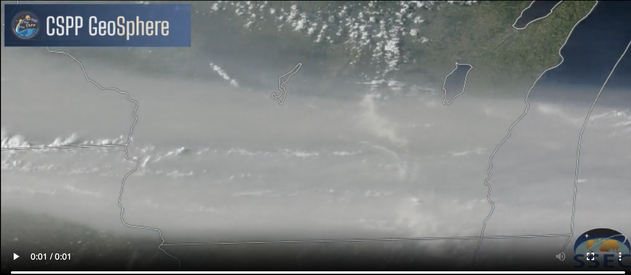
SSEC and CIMSS Scientists in the News:: Scientists at the University of Wisconsin-Madison (UW) Space Science and Engineering Center (SSEC) and the Cooperative Institute for Meteorological Satellite Studies (CIMSS) provide expert interviews, imagery and case studies to promote science. This week: CIMSS Satellite Blog contributors Alexa Ross, Scott Lindstrom and Scott Bachmeier published these case studies: "SAR winds with cloud lines north of Hawai’i" (May 17, 2023), "Wildfire smoke, a cold front and a “Pnuemonia Front” (May 16, 2023), "Geosphere views of Smoke over Canada and the northern USA" (May 16, 2023), "TROPICS views of Cyclone Mocha" (May 16, 2023), "LightningCast Probabilities over the tropical Pacific Ocean" (May 16, 2023), " Cyclone Mocha reaches Category 5 intensity" (May 14, 2023), "Large hail and heavy rainfall in the St. Louis area" (May 13, 2023). Read more at the CIMSS Satellite Blog: https://cimss.ssec.wisc.edu/satellite-blog/. (S. Lindstrom, CIMSS, S. Bachmeier, CIMSS, A. Ross CIMSS, E. Verbeten, SSEC)
 (Click image to enlarge and animate)
Figure: (1) the arrival of a dense band of smoke aloft — transported southward from wildfires in Alberta and Saskatchewan — which reduced incoming solar radiation, (2) a southward-moving cold front and (3) the inland surge of a lake breeze (or “Pneumonia Front“) from Lake Michigan. Signatures of all 3 features were evident in GOES-16 (GOES-East) True Color RGB images, with the cold front and lake breeze marked by broken lines of cumulus clouds that could be seen through the thick veil of smoke.
PUBLICATIONS:
Ammonia study using Collocated Sounder/Imager Product published: The following paper has been published: White, E.; Shephard, M.W.; Cady-Pereira, K.E.; Kharol, S.K.; Ford, S.; Dammers, E.; Chow, E.; Thiessen, N.; Tobin, D.; Quinn, G.; O’Brien, J.; Bash, J. Accounting for Non-Detects: Application to Satellite Ammonia Observations. Remote Sens. 2023, 15, 2610. https://doi.org/10.3390/rs15102610. This paper introduces a methodology to explicitly identify and account for cloud-free satellite measurements below a sensor’s measurement detection level, and applies it to gridded ammonia products derived from Cross-track Infrared Sounder (CrIS). Not accounting for non-detects can result in significant high-bias averaged measurements in locations that exhibit conditions below the sensor detection limit, resulting in reduced capability to accurately characterize emission sources. This approach relies on use of the official mission length University of Wisconsin collocated CrIS Visible Infrared Imaging Radiometer Suite (VIIRS) Sounder/Imager IMG product suite, which contains statistics of the VIIRS products within each CrIS footprint. (D. Tobin, CIMSS, 608-265-6281)
OTHER:
| Archived Weeklies Page | Submit a report item |