[ Archive ]
| CIMSS-NOAA Weekly Report [ Archive ] |
CIMSS AND ASPB WEEKLY HIGHLIGHTS FOR THE WEEK ENDING MAY 26, 2023
DATA, INFORMATION, AND USE-INSPIRED SCIENCE:
FUTURE OUTLOOK:
AWARDS AND RECOGNITION:
TRAVEL AND MEETINGS:
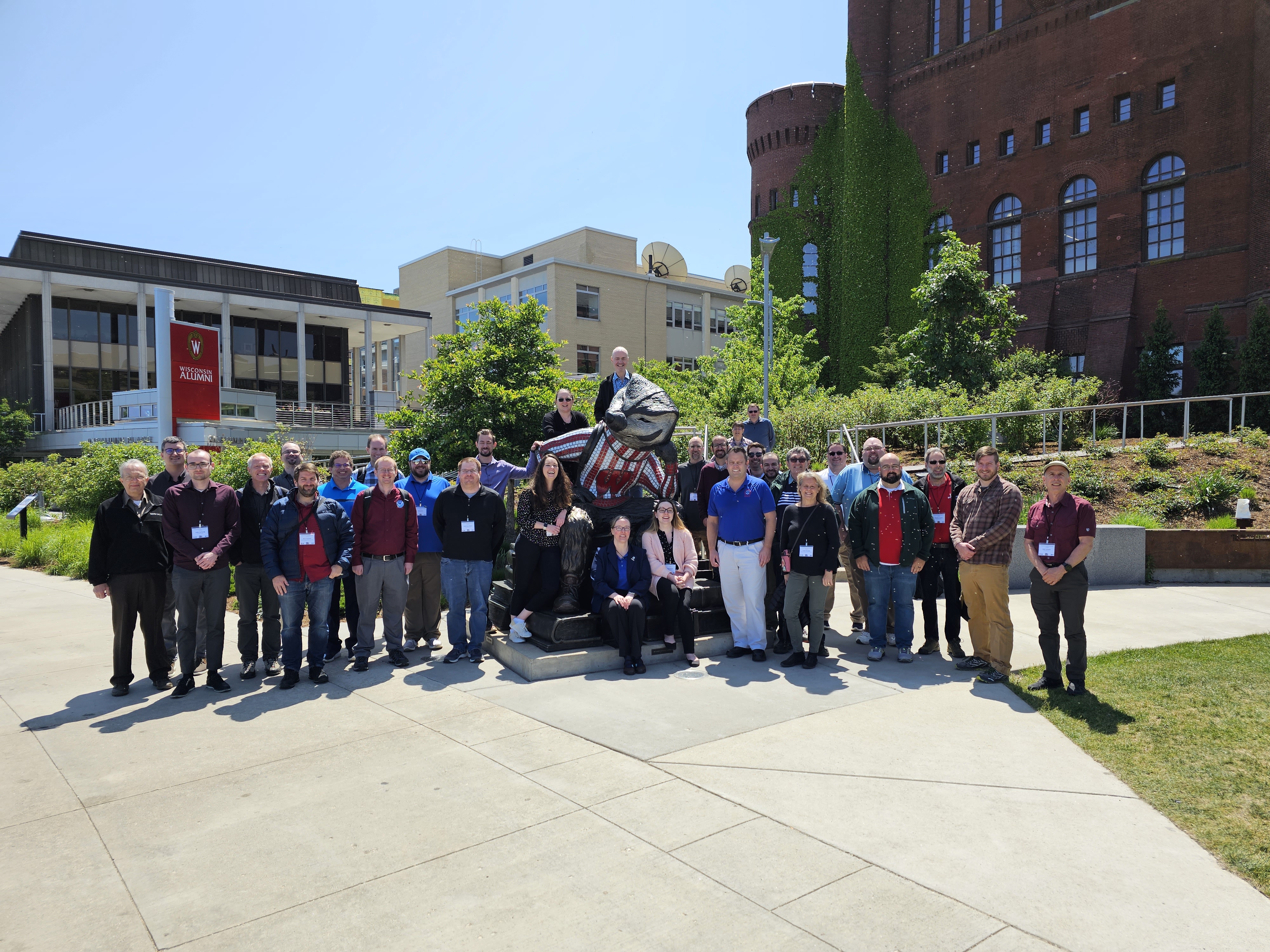
CIMSS Participation in the 29th Great Lakes Operational Meteorology Workshop (GLOMW): The 29th Great Lakes Operational Meteorology Workshop (GLOMW), an annual gathering of Great Lakes forecasters from the National Weather Service (US) and ECCC (Canada), was held this year on the UW-Madison campus 24-25 May 2023 in a collaboration between the Cooperative Institute for Meteorological Satellite Studies (CIMSS), the National Weather Service forecast office in Sullivan WI (WFO MKX) (John Gagan, SOO) and the National Weather Service Office of Observations (NWS/OBS), represented by Jordan Gerth. This meeting brings together forecasters and Science and Operations Officers (SOOs) from offices stretching from Duluth to Buffalo, and ECCC forecasters/analysts from Ontario with presentations and discussions focused on events that are near, or influenced by, the Great Lakes. CIMSS and STAR presentations included uses and sources of GOES-R ABI Data (T. Schmit), Enterprise Cloud Products around the Great Lakes (M. Kulie), SAR Imagery around the Great Lakes (S. Lindstrom), Prob Severe products (J. Sieglaff), RealEarth products relevant over the Great Lakes (S. Batzli), and the History of Satellite Meteorology and SSEC (J. Phillips, SSEC). The GLOMW 2023 website is here: https://www.ssec.wisc.edu/meetings/glomw/2023-meeting/. (T. Schmit, M. Kulie, NOAA/STAR; S. Batzli, J. Phillips, J. Sieglaff, S. Lindstrom, CIMSS)
 (Click image to enlarge)
Figure: GLOMW Participants on 25 May 2023 on the UW-Madison Campus. (Photo credit: S. Lindstrom)
TRAINING AND EDUCATION:
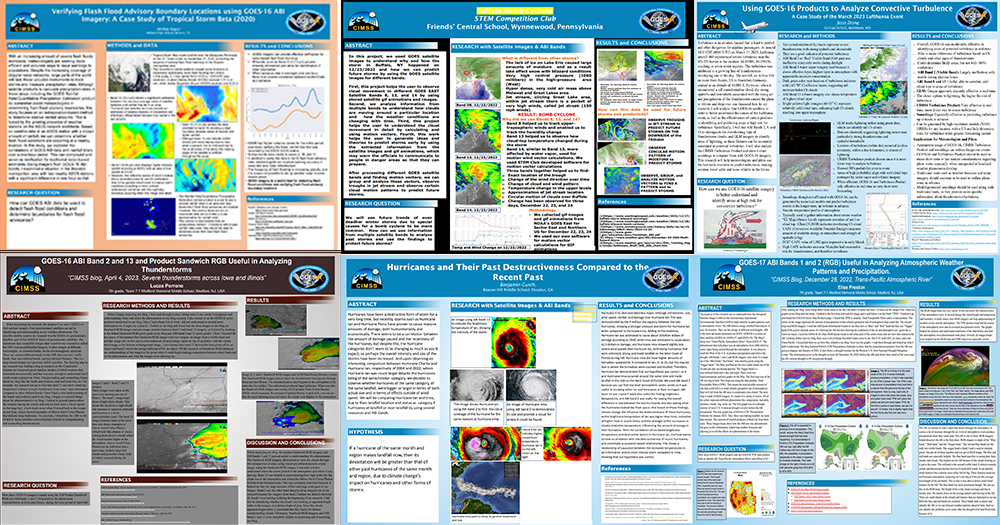
GOES Virtual Science Fair Top Projects: The GOES Virtual Science Fair for Grades 6-12 top projects were announced this week with entries from seven different states. The top High School project came from Texas on "Verifying Flash Flood Advisory Boundary Locations using GOES-16 ABI Imagery: A Case Study of Tropical Storm Beta (2020)". The top Middle School project was from New Jersey and titled "GOES-16 ABI Band 2 and 13 and Product Sandwich RGB Useful in Analyzing Thunderstorms". Honorable mentions were also awarded at both levels. These tops project posters and presentations can be found online at http://cimss.ssec.wisc.edu/education/goesr/1stPlace2023.html. (Margaret Mooney, CIMSS, 608-265-2123, T. Schmit, E/RA2, M. Gunshor, CIMSS)
 (Click image to enlarge)
Figure: GOES VSF Poster Collage.
CIMSS Participation at the First week of the Hazardous Weather Testbed: The first week at the Hazardous Weather Testbed -- in person for the first time since 2019 -- occurred the week of 22-26 May 2023 in Norman. The Cooperative Institute for Meteorological Satellite Studies (CIMSS) provided products and subject matter experts for three of the products demonstrated. ProbSevere version 3 and LightningCast Probability products were guided by John Cintineo (who was on site at HWT to answer forecaster questions) and Lee Cronce (supporting remotely from CIMSS). Feedback from HWT helps to guide future directions of ProbSevere and LightningCast development. Polar Hyperspectral Sounding with Microwave and ABI model output (PHSnMWnABI, PHS for short) was guided by Bill Smith, Sr. (on-site) and Scott Lindstrom (remotely from CIMSS). PHS model output was used to help forecasters focus on locations where convection might be occurring in the next 2-6 hours. HWT continues -- 100% remotely -- on June 5th. Forecaster reactions/evaluations on these (and other products) can be read at this blog: https://inside.nssl.noaa.gov/ewp/. (J. Cintineo, L. Cronce, W. Smith Sr., S. Lindstrom, CIMSS, 608 263 4425)
MEDIA INTERACTIONS AND REQUESTS:
SOCIAL MEDIA AND BLOG Posts:
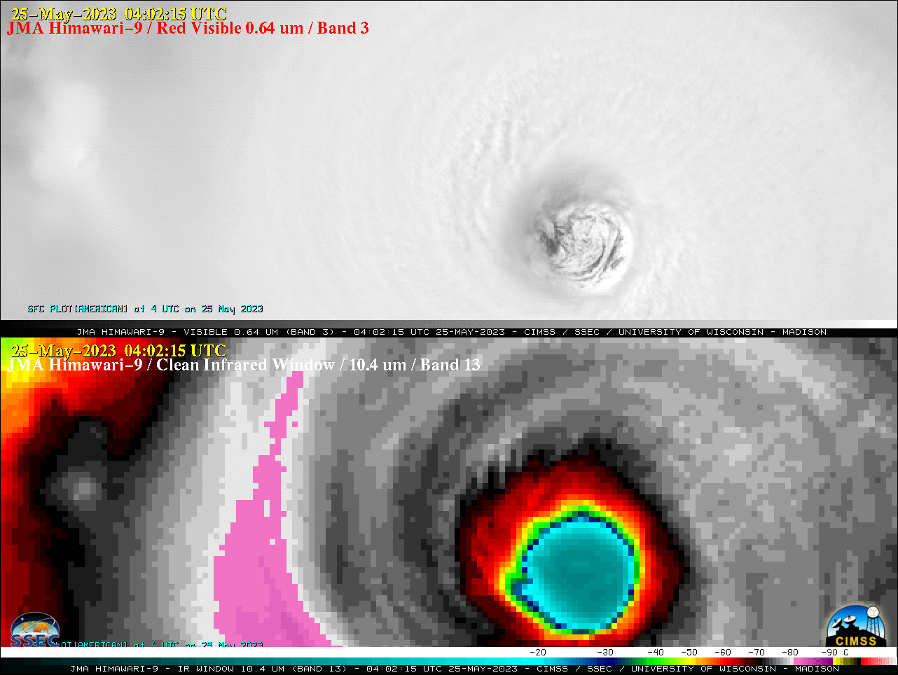
SSEC and CIMSS Scientists in the News: Scientists at the University of Wisconsin-Madison (UW) Space Science and Engineering Center (SSEC) and the Cooperative Institute for Meteorological Satellite Studies (CIMSS) provide expert interviews, imagery and case studies to promote science. This week: CIMSS Satellite Blog contributors Scott Lindstrom and Scott Bachmeier published these case studies: “Super Typhoon Mawar reaches Category 5 intensity” (May 25, 2023), “Typhoon Mawar moves through the Rota Channel” (May 24, 2023), “Polar Hyperspectral Soundings in numerical model output at the Hazardous Weather Testbed” (May 23, 2023), “NUCAPS Profiles near Typhoon Mawar (added: And Day Night Band imagery with Mesospheric Gravity Waves)” (May 23, 2023), “Super Typhoon Mawar” (May 23, 2023), “Typhoon Mawar reaches Category 4 intensity” (May 22, 2023), “Increases in Mawar’s winds diagnosed from SAR data” (May 22, 2023), “SAR Winds over Tropical Storm Mawar to the southeast of Guam” (May 21, 2023), “1-minute imagery of wildfires and pyrocumulonimbus clouds in British Columbia” (May 20, 2023), “Tropical Storm Mawar in the West Pacific Ocean” (May 20, 2023), “British Columbia wildfire produces a pyrocumulonimbus cloud” (May 19, 2023), “Heavy rain over Kona, Hawai’I” (May 19, 2023), “Tropical Disturbance in the Federated States of Micronesia” (May 19, 2023). Read more at the CIMSS Satellite Blog: https://cimss.ssec.wisc.edu/satellite-blog/. (S. Lindstrom, CIMSS, S. Bachmeier, CIMSS, E. Verbeten, SSEC)
 (Click image to enlarge)
Figure: JMA Himawari-9 Visible and Infrared images covered the period +/- 2 hours when Super Typhoon Mawar reached Category 5 intensity at 0600 UTC on 25 May 2023.
PUBLICATIONS:
Article Awarded Editor's Choice Status: The 2021 Remote Sensing article "Application of a Convolutional Neural Network for the Detection of Sea Ice Leads" (https://doi.org/10.3390/rs13224571), has been selected as an Editor's Choice Article. This distinction is only given to small number of recently published articles that the journal editors highlight as some of the most exciting work published in the journal. Authors are Jay Hoffman (CIMSS), Steve Ackerman (CIMSS), Yinghui Liu (ASPB), Jeff Key (ASPB), and Iain McConnell (SSEC). More information on the project is available at https://www.ssec.wisc.edu/leads. (J. Hoffman, CIMSS 608-890-1690)
Paper published on enhanced Storm Warning and Nowcasting Model in Pre-Convection Environments: A manuscript titled "An Enhanced StormWarning and Nowcasting Model in Pre-Convection Environments” was published in the journal Remote Sensing. This study presents an enhanced storm tracking and nowcasting model where continuous tracking was introduced. The model uses ABI and NWP forecast as input and focuses on early warnings for local severe storms associated with heavy precipitations over the CONUS. Evaluations show that ABI has much higher impact than NWP forecasts. Larger storms are easier to nowcast than smaller ones. A case study demonstrated that the model successfully provides warnings with a lead time 1-2 hours before heavy precipitation. Citation: Ma, Z.; Li, Z.; Li, J.; Min, M.; Sun, J.; Wei, X.; Schmit, T.J.; Cucurull, L. An Enhanced Storm Warning and Nowcasting Model in Pre-Convection Environments. Remote Sens. 2023, 15, 2672. https://doi.org/10.3390/rs15102672. (Z. Li, CIMSS, 608-890-1982)
OTHER:
| Archived Weeklies Page | Submit a report item |