[ Archive ]
| CIMSS-NOAA Weekly Report [ Archive ] |
CIMSS AND ASPB WEEKLY HIGHLIGHTS FOR THE WEEK ENDING JUNE 2, 2023
DATA, INFORMATION, AND USE-INSPIRED SCIENCE:
CIMSS-developed SIFT tool used for EUMETSAT demonstration/training on MTG/FCI imagery: An introductory training session from EUMETSAT on Flexible Combined Imager (FCI) imagery from the recently-launched Meteosat Third Generation (MTG) satellite used the Satellite Information Familiarization Tool (SIFT) to demonstrate some of the capabilities of multispectral iamgery. SIFT was originally developed at the Cooperative Institute for Meteorological Satellite Studies (CIMSS) in 2015/2016 for NWS Satellite training on Himawari and GOES-R Imagery. The original funding for this development was through NWS/STI. Starting in 2022, scientists at (or associated with) EUMETSAT, and its contractor Innovative Visualisierungslösungen GmbH in Germany, in collaboration with CIMSS scientists and software developers, have amended and improved the SIFT tool to better incorporate the multispectral FC1 data and to improve performance. A YouTube video of the demonstration is available here: https://www.youtube.com/watch?v=ilUmKkJVtqw. (J. Gerth, NWS/OBS; D. Hoese, R. Garcia, S. Lindstrom, CIMSS, 608 263 4425)
FUTURE OUTLOOK:
AWARDS AND RECOGNITION:
TRAVEL AND MEETINGS:
WDNR Air Management Advisory Group: Brad Pierce attended the Wisconsin Department of Natural Resources (DNR) Air Management Advisory Group Meeting on June 1, 2023 in Madison WI. The Air Management Advisory Group is a stakeholder working group that provides the Air Program with constructive feedback on policy and technical issues. He presented an overview of plans for the NASA/NOAA airborne field campaigns and Tropospheric Emissions: Monitoring of Pollution (TEMPO) validation that will be conducted during July-August, 2023. The NOAA Coastal Urban Plume Dynamics Study (CUPiDS) and Atmospheric Emissions and Reactions Observed from Megacities to Marine Areas (AEROMMA) and the NASA Synergistic TEMPO Air Quality Science (STAQS) will bring an unprecedented amount of airborne and ground based measurements to the Chicago/Lake Michigan area to help improve our understanding of ozone formation in Wisconsin. Measurements collected this summer will be used to validate TEMPO retrievals so that they can be used to further improve our understanding of diurnal variations in ozone precursors in the Chicago/Lake Michigan region. TEMPO is a NASA Earth Venture mission similar to the NOAA Geostationary Extended Observations (GeoXO) Atmospheric Composition instrument (ACX). TEMPO will serve as a valuable proxy to develop capabilities to utilize ACX measurements within NOAA operational air quality forecasting. (R.B. Pierce, SSEC, 608-890-1892)
TRAINING AND EDUCATION:
MEDIA INTERACTIONS AND REQUESTS:
SOCIAL MEDIA AND BLOG Posts:
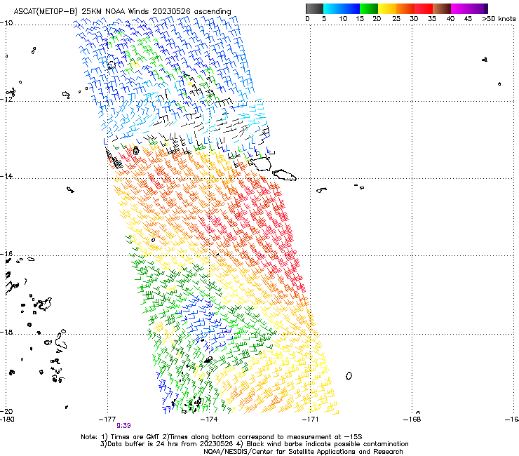
CIMSS Blog Post on Rain/Wind event in Pago Pago: As a result of a discussions during a weekly satellite training telecon with members of the National Weather Service office in Pago Pago, Scott Lindstrom from the Cooperative Institute for Meteorological Satellite Studies (CIMSS) created a blog post on the heavy rain (4+ inches) and wind (30-40 knots gusts) event that occurred on/around the island of Tutuila, American Samoa, on 26 May 2023. The NWS forecast office in Pago Pago issued Flood, Wind and Small Craft Advisories before/during the event, and Flash Flood warnings during the event. For more information on this event, see https://cimss.ssec.wisc.edu/satellite-blog/archives/52730. (S. Lindstrom, CIMSS, 608 263 4425)
 (Click image to enlarge)
Figure: MetopB Advanced Scatterometer (ASCAT) winds from ca. 0930 UTC on 26 May 2023. Very strong winds are indicated to the south of the Samoan Islands.
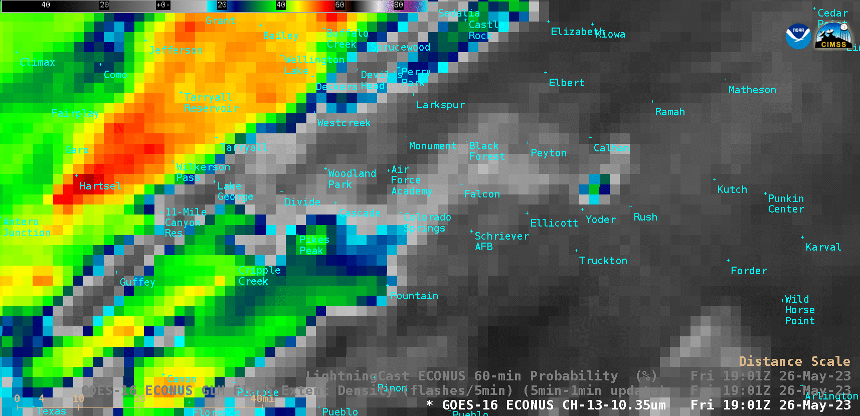
SSEC and CIMSS Scientists in the News: Scientists at the University of Wisconsin-Madison (UW) Space Science and Engineering Center (SSEC) and the Cooperative Institute for Meteorological Satellite Studies (CIMSS) provide expert interviews, imagery and case studies to promote science. This week: CIMSS Satellite Blog contributors Scott Lindstrom, Scott Bachmeier, and Margaret Mooney published these case studies: “Tropical Depression Two develops in the Gulf of Mexico” (June 01, 2023), "Wildfires in Nova Scotia" (May 31, 2023), "Satellite Data in STEM Education" (May 31, 2023), "Long animations of Typhoon Mawar in the western Pacific" (May 29, 2023), "Anomalously low ice concentration in Canada’s Amundsen Gulf" (May 29, 2023), "2 people struck by lightning on a Colorado Springs golf course; LightningCast lead time" (May 29, 2023), "Launch of two more TROPICS cubesats as viewed (maybe!) by GOES-18" (May 26, 2023), "Eruptive period of Popocatépetl in Mexico" (May 25, 2023). Read more at the CIMSS Satellite Blog: https://cimss.ssec.wisc.edu/satellite-blog/. (S. Lindstrom, CIMSS, S. Bachmeier, CIMSS, M. Mooney, CIMSS/SSEC, 608-265-2123, E. Verbeten, SSEC)
 (Click image to enlarge)
PUBLICATIONS:
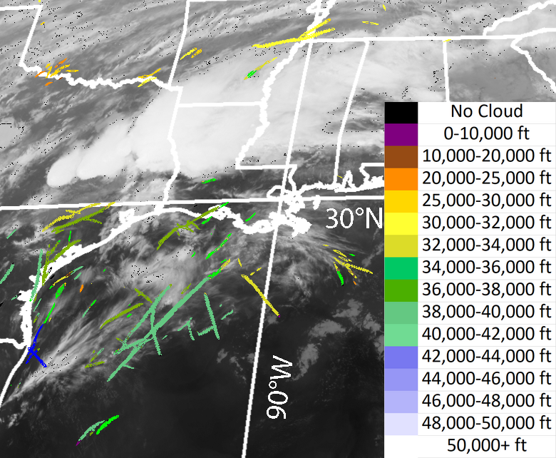
Contrail Detection Paper Published: A paper titled "The Application of a Convolutional Neural Network for the Detection of Contrails in Satellite Imagery" by Jay Hoffman (Cooperative Institute for Meteorological Satellite Studies, CIMSS), Tim Rahmes (Boeing), Tony Wimmers (CIMSS), and Wayne Feltz (CIMSS) has been published in the Deep Learning for Satellite Image Segmentation Special Issue of Remote Sensing. The paper shows that AI that originally developed to detect sea ice leads can be retrained and used to detect contrails. Citation: Hoffman, J., T. Rahmes, T. Wimmers, and W. Feltz, 2023, The Application of a Convolutional Neural Network for the Detection of Contrails in Satellite Imagery, Remote Sensing, 15(11), 2854, https://doi.org/10.3390/rs15112854. (J. Hoffman, CIMSS 608-890-1690)
 (Click image to enlarge)
Figure: Example image of contrails detected by GOES-16 on March 10, 2023 at 0420 UTC. Contrail detections are color-coded by height and overlaid on a 11 µm brightness temperature image.
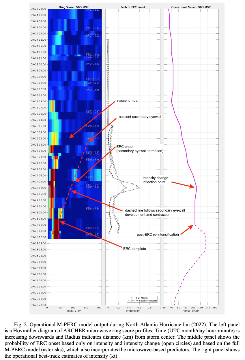
Paper published on satellite-based model to diagnose structure changes in tropical cyclones: A manuscript titled “M-PERC: A New Satellite Microwave-Based Model to Diagnose the Onset of Tropical Cyclone Eyewall Replacement Cycles” was accepted for publication in the AMS journal Weather and Forecasting. The M-PERC model uses passive microwave satellite imagery in the 85-92 GHz frequencies along with storm intensity to produce probabilities of the onset of an eyeyall replacement cycle (ERC) in tropical cyclones. The changes to the internal structure of the storm from these ERCs can impact the short-term intensity change of the storm and is used as both an analysis diagnostic tool and short-term (less than 36 hours) forecast aid to adjust the forecast storm intensity. The algorithm has been used by forecasters at agencies such as the National Hurricane Center, Australia Bureau of Meteorology and the Joint Typhoon Warning Center. Citation: Kossin, J. P., D. C. Herndon, A. J. Wimmers, X. Guo, and E. S. Blake, 2023: M-PERC: A New Satellite Microwave-Based Model to Diagnose the Onset of Tropical Cyclone Eyewall Replacement Cycles. Wea. Forecasting, https://doi.org/10.1175/WAF-D-22-0178.1, in press.
 (Click image to enlarge)
OTHER:
| Archived Weeklies Page | Submit a report item |