[ Archive ]
| CIMSS-NOAA Weekly Report [ Archive ] |
CIMSS AND ASPB WEEKLY HIGHLIGHTS FOR THE WEEK ENDING JULY 14, 2023
DATA, INFORMATION, AND USE-INSPIRED SCIENCE:
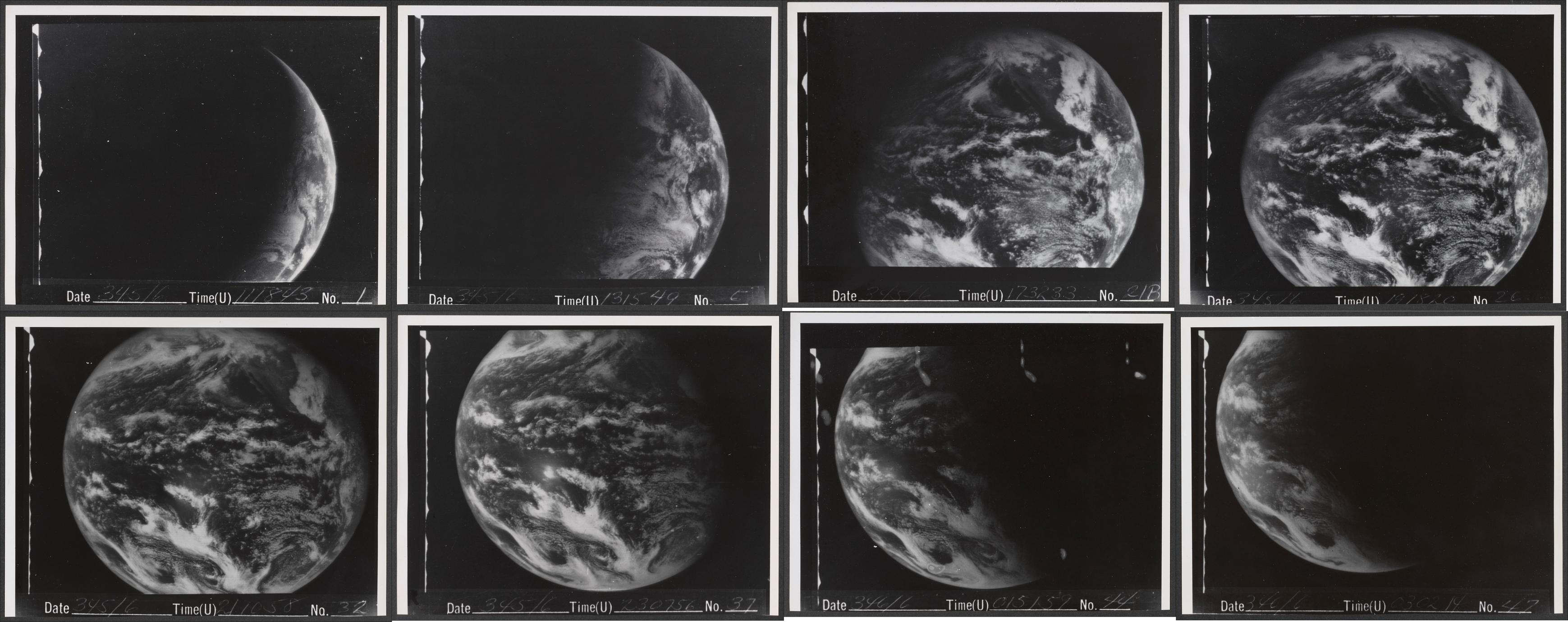
Select ATS-1/3 Images in UW-Madison Digital Collections: Via internal funding, the University of Wisconsin-Madison/SSEC has digitized over 66,000 Applications Technology Satellite (ATS)-1/3 images from the late 1960s to early 1970s. ATS were experimental NASA geostationary satellites, with UW's Spin Scan Cloud Camera. A small subset of these images have been placed into a permanent collection as part of the UW-Madison Digital Collections. More information see https://search.library.wisc.edu/digital/AATSimg. Much work remains to prepare the larger dataset for use. (J. Phillips, SSEC; J. Robaidek, SSEC; T. Schmit, E/RA2, 608-263-0291)
 (Click image to enlarge)
Figure: A time series of the first geostationary visible images from the Spin Scan Cloud Camera on December 11, 1966 from NASA's ATS-1.
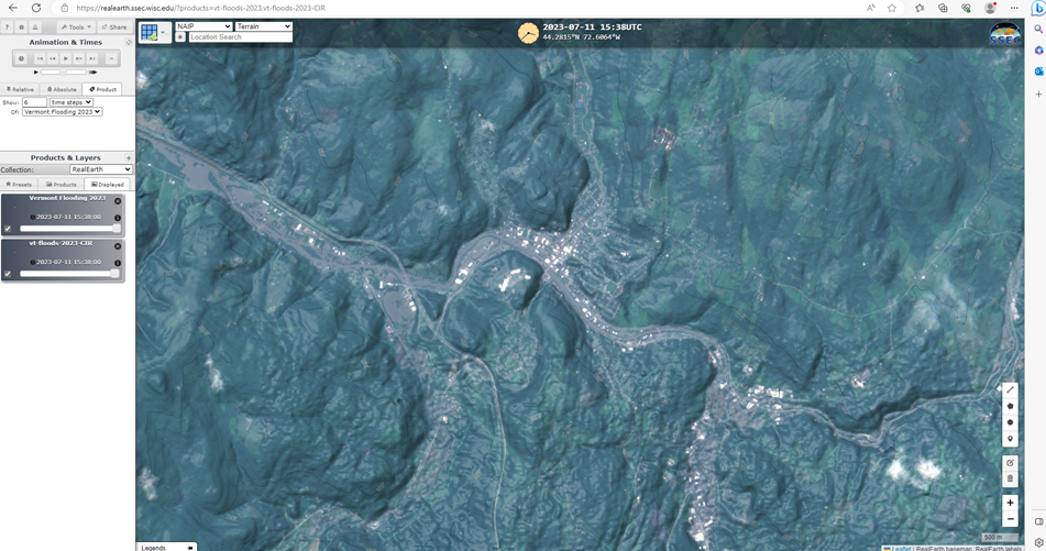
SSEC Responds to Vermont Flooding Imagery Request: The State of Vermont experienced historical flooding on July 11-12, 2023. Nearly all parts of the state were affected. Jarlath O’Neil-Dunne, Director of the Spatial Analysis Laboratory of the University of Vermont and US Forest Service affiliate sent out a help request to the AmericaView.org network of which the University of Wisconsin Space Science and Engineering Center (SSEC) is a member through the WisconsinView program and PI Sam Batzli. Dr. Batzli in-turn enlisted the help of William Straka and Danielle Losos (also of SSEC and the Cooperative Institute for Meteorological Satellite Studies (CIMSS)). While S. Batzli identified and downloaded and processed Sentinel-2a imagery into 4-band GeoTIFF composites and RealEarth products, W. Straka identified relevant flood mapping products from the JPSS Flood Initiative, and D. Losos generated a Sentinel-2 10m resolution before/after flood water map for the cloud-free lower two-thirds of the state using a creatively modified normalized burn ratio algorithm she implemented in Google Earth Engine. Within hours of the request SSEC/CIMSS had contributed five significant, and in some cases unique, satellite imagery-derived maps and map services. (S. Batzli, SSEC/ERSC)
 (Click image to enlarge)
Figure: This animated GIF toggles a Google Earth Engine-derived before/after flood map of surface water (dark blue) from Sentinel-2 satellite images representing June 11, 2023 (before) and July 11, 2023 (after) centered on Montpelier, VT. https://re.ssec.wisc.edu/s/42Gvzu. Credit: D. Losos SSEC/CIMSS
 (Click image to enlarge)
Figure: True color Sentinel-2 satellite image with terrain overlay from July 11, 2023 15:38UTC centered on Montpelier, VT and displayed in RealEarth to support request for assistance from the Spatial Analysis Lab at the University of Vermont during historic flooding. Credit: S. Batzli SSEC/CIMSS
FUTURE OUTLOOK:
AWARDS AND RECOGNITION:
TRAVEL AND MEETINGS:
TRAINING AND EDUCATION:
MEDIA INTERACTIONS AND REQUESTS:
SOCIAL MEDIA AND BLOG Posts:
SSEC and CIMSS Scientists in the news: Scientists at the University of Wisconsin-Madison (UW) Space Science and Engineering Center (SSEC) and the Cooperative Institute for Meteorological Satellite Studies (CIMSS) provide expert interviews, imagery and case studies to promote science. This week: 1) CIMSS scientist Jason Otkin conducted an interview with Wisconsin Public Radio The Morning Show to discuss the recent impacts flash droughts have been having on Wisconsin Farms. Jason's segment begins at 21:10 https://www.wpr.org/shows/drought-affecting-wisconsin-farms-understanding-flash-droughts. 2) CIMSS Satellite Blog contributors Tim Schmit, Scott Lindstrom, Scott Bachmeier and Alexa Ross published these case studies: "CIMSS Anniversary" (June 14), "Using NODD and Polar2Grid to create Day Night Band imagery anywhere" (July 13), "Geo-Browser Adds SUVI Images" (July 13), "Hail damage swath in Wyoming" (July 12), "Tropical Storm Calvin forms in the eastern Pacific" (July 12) "Sentinel 2A views Vermont Flooding" (July 11), "Pallet Fire near Coloma in central Wisconsin" (July 11), "SAR Data with a severe thunderstorm off the coast of Florida" (July 09), and "Using microwave data to distinguish between rain and just cloudy underneath clouds" (July 09). Read more at the CIMSS Satellite Blog: https://cimss.ssec.wisc.edu/satellite-blog/. (S. Lindstrom, CIMSS, A. Ross, SSEC, S. Bachmeier, CIMSS, T. Schmit, E/RA2, 608-263-0291, tim.j.schmit@noaa.gov, E. Verbeten, SSEC, 608-263-4206
 (Click image to enlarge)
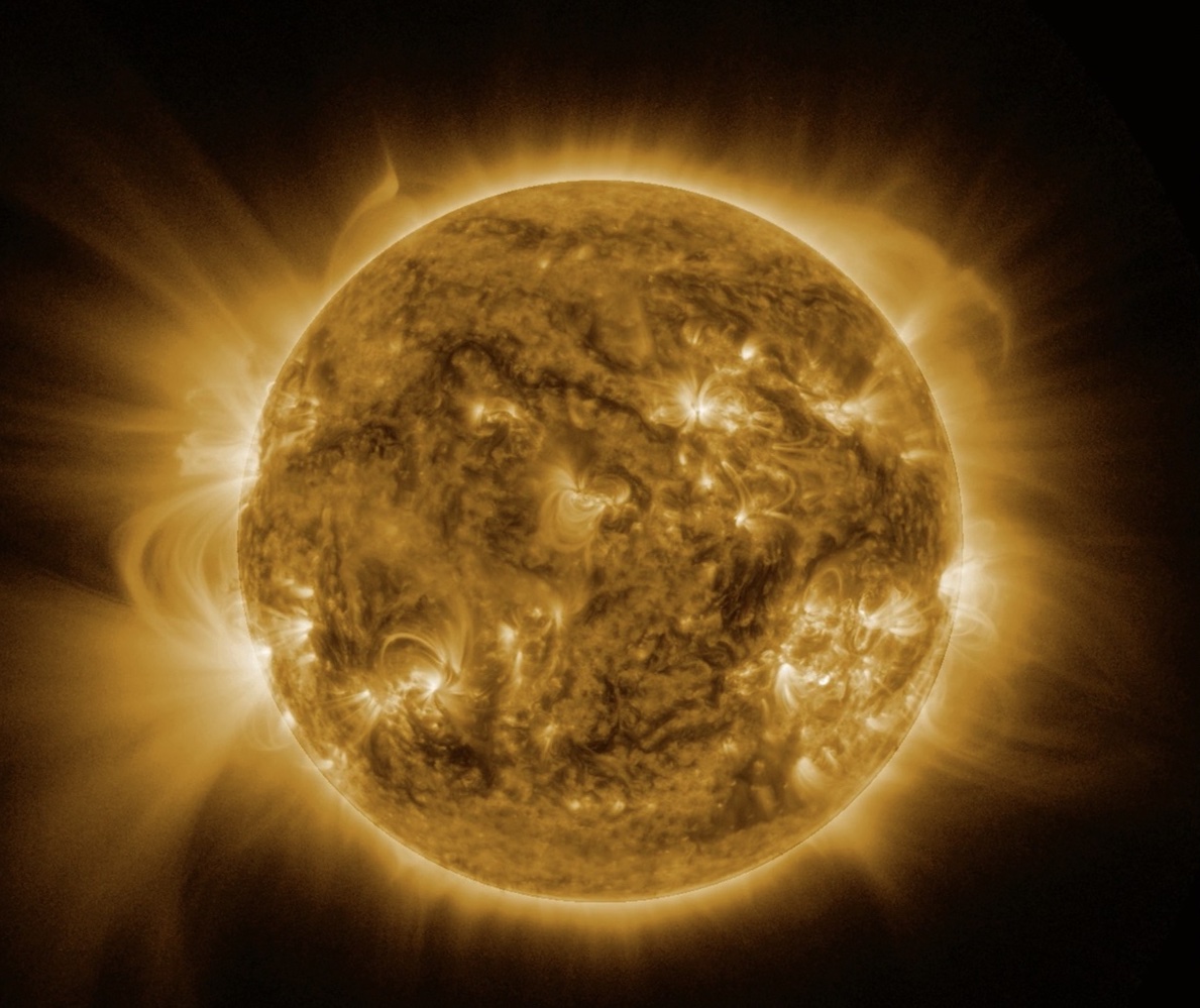
Figure: There are six spectral bands on the SUVI; this table from the Volume 3 PUG shows the various uses. These images, built from the GRB data stream, include the six spectral bands.
PUBLICATIONS:
Infrared Hyperspectral Observation Inter-calibration paper published: The following paper by Michelle Loveless et. al. has been published: Loveless, M., Knuteson, R., Revercomb, H., Borg, L., DeSlover, D., Martin, G., Taylor, J., Iturbide-Sanchez, F., Tobin, D., (2023). Comparison of the AIRS, IASI, and CrIS Infrared Sounders using Simultaneous Nadir Overpasses: Novel Methods applied to data from 1 October 2019 to 1 October 2020. Earth and Space Science, 10, e2023EA002878. https://doi.org/10.1029/2023EA002878. This study was performed under NOAA (CIMSS) Grant Number: NA20NES4320003, and demonstrates the very good calibration accuracy of today's infrared hyperspectral sounders required for atmospheric sounding, climate studies, and other applications. (D. Tobin, CIMSS, 608-265-6281)
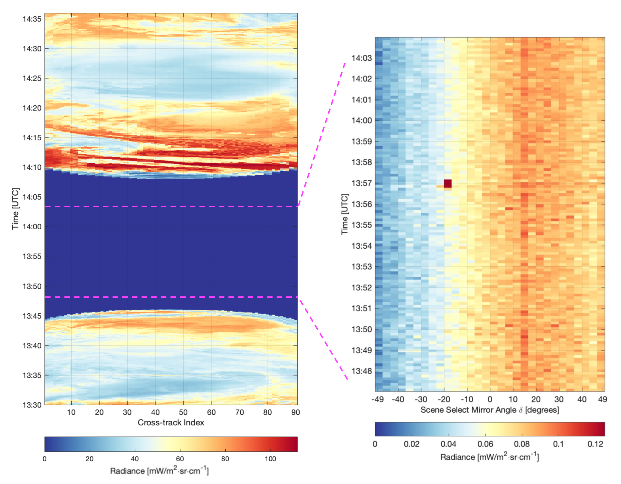
NOAA-21 CrIS Polarization Characterization and Correction Coefficients: Using special pitch maneuver data collected early in the mission, the polarization effects and associated calibration correction coefficients for the NOAA-21 Cross-track Infrared Sounder (CrIS) sensor have been determined and made available to NOAA for inclusion in the operational calibration algorithm, with results available for the Validated Maturity Review scheduled for September 2023. The analysis follows the same approach as used for S-NPP and NOAA-20 CrIS sensors as described in: Taylor, J.K.; Revercomb, H.E.; Tobin, D.C.; Knuteson, R.O.; Loveless, M.L.; Malloy, R.; Suwinski, L.; Iturbide-Sanchez, F.; Chen, Y.; White, G.; et al. Assessment and Correction of View Angle Dependent Radiometric Modulation due to Polarization for the Cross-Track Infrared Sounder (CrIS). Remote Sens. 2023, 15, 718. https://doi.org/10.3390/rs15030718. This work was funded in part by NOAA (CIMSS) Grant Number NA20NES4320003. (J. Taylor, CIMSS, 608-263-4494; D. Tobin, CIMSS, 608-265-6281)
 (Click image to enlarge)
Figure: Example time series of CrIS Longwave band radiances during a pitch maneuver (Left panel) and a ~5 minute period when all footprints were viewing deep space (Right panel), demonstrating the view angle dependence of the calibration without polarization correction in place.
OTHER:
| Archived Weeklies Page | Submit a report item |