[ Archive ]
| CIMSS-NOAA Weekly Report [ Archive ] |
CIMSS AND ASPB WEEKLY HIGHLIGHTS FOR THE WEEK ENDING AUGUST 11, 2023
DATA, INFORMATION, AND USE-INSPIRED SCIENCE:
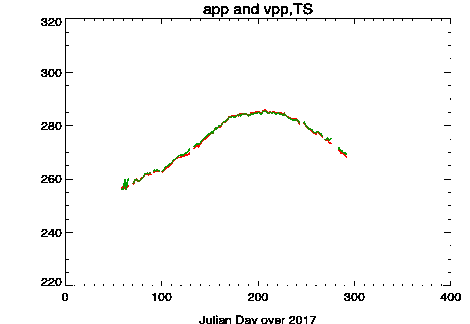
Using VIIRS data in long-term climate data records: With JPSS Visible Infrared Imaging Radiometer Suite (VIIRS) data being available starting from 2012, we employ VIIRS Global Area Coverage (VGAC) data to create VIIRS Polar Pathfinder (VPP) and Extended VIIRS Polar Pathfinder (VPP-x) CDRs, being matched with the current APP and APP-x CDRs both spatially and temporarily to extend current CDRs into VIIRS era for climate study. Figure 1 shows the time series of the surface skin temperature from NOAA-19 AVHRR (red curve) and VIIRS (green curve) over the year 2017 at 14:00 local solar time for the Arctic region north of 60 degrees. There is good agreement between APP and VPP, and between APP-x and VPP-x, not just for surface temperature but for all the geophysical variables in APP-x. The VPP and VPP-x CDRs are delivered to NCEI for wide use by the public. (X. Wang, CIMSS, 608-261-1390)
 (Click image to enlarge)
Figure: Time series of surface skin temperature from NOAA-19 AVHRR (red) and VIIRS (green) over the year 2017 at 14:00 local solar time for the Arctic region north of 60 degrees latitude.
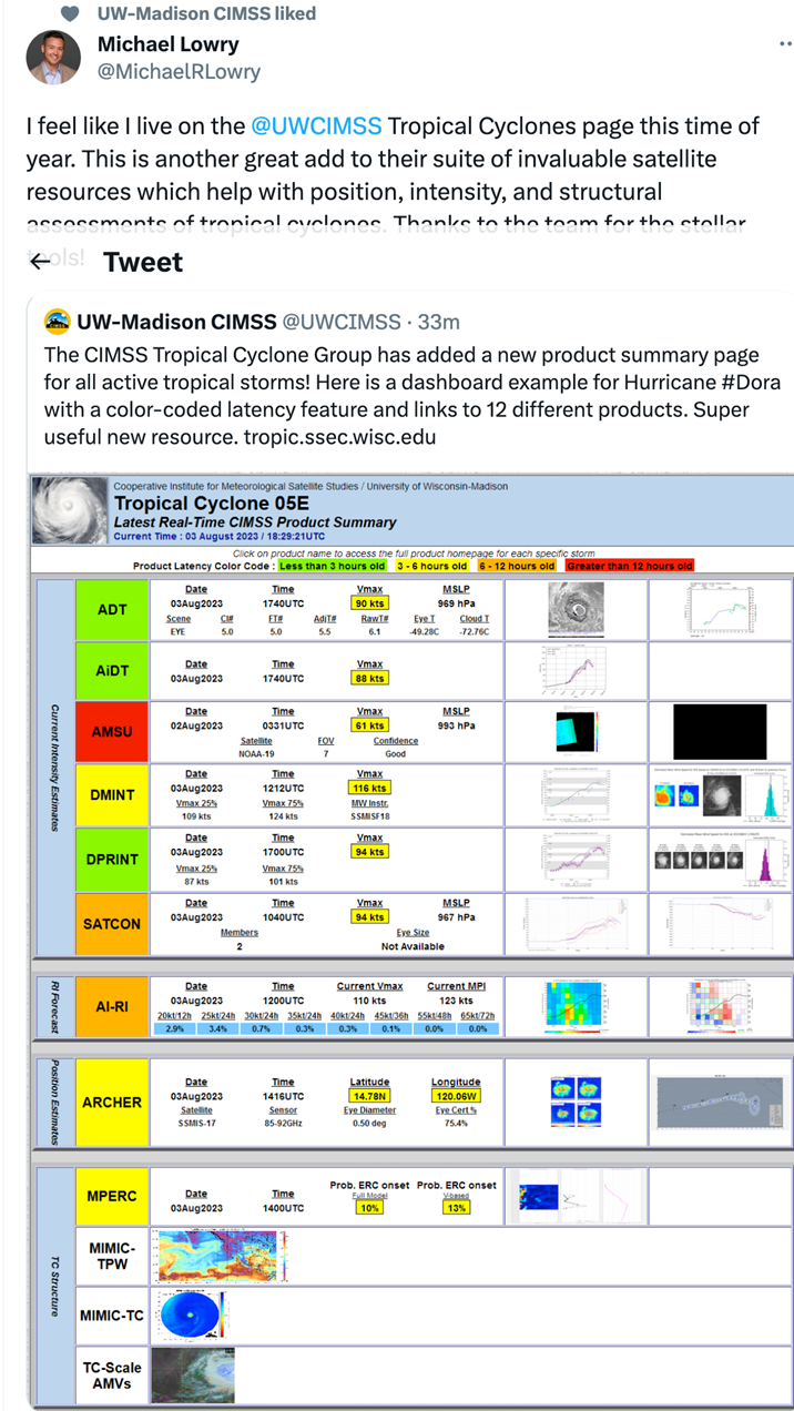
New product summary on CIMSS Tropical Cyclone webpage: The Cooperative Institute for Meteorological Satellite Studies (CIMSS) Tropical Cyclone group has introduced a new product summary page for active storms on their popular website (https://tropic.ssec.wisc.edu/). This new page provides a summary of all of the CIMSS storm-specific intensity, structure, and positioning products in one place, for every active tropical cyclone around the globe, to allow quick access to forecasters who rely on these products to do their job effectively. These new summary pages were positively received by forecasters and tropical cyclone enthusiasts who provided feedback via email, X (formerly Twitter), and other social media sites. (T. Olander, CIMSS, 608-265-8005, C. Velden, CIMSS, 608-262-9168, J. Hawkins, CIMSS).
 (Click image to enlarge)
Figure: Initial CIMSS post and reaction on X to the release of the storm-specific product summary pages.
FUTURE OUTLOOK:
AWARDS AND RECOGNITION:
TRAVEL AND MEETINGS:
TRAINING AND EDUCATION:
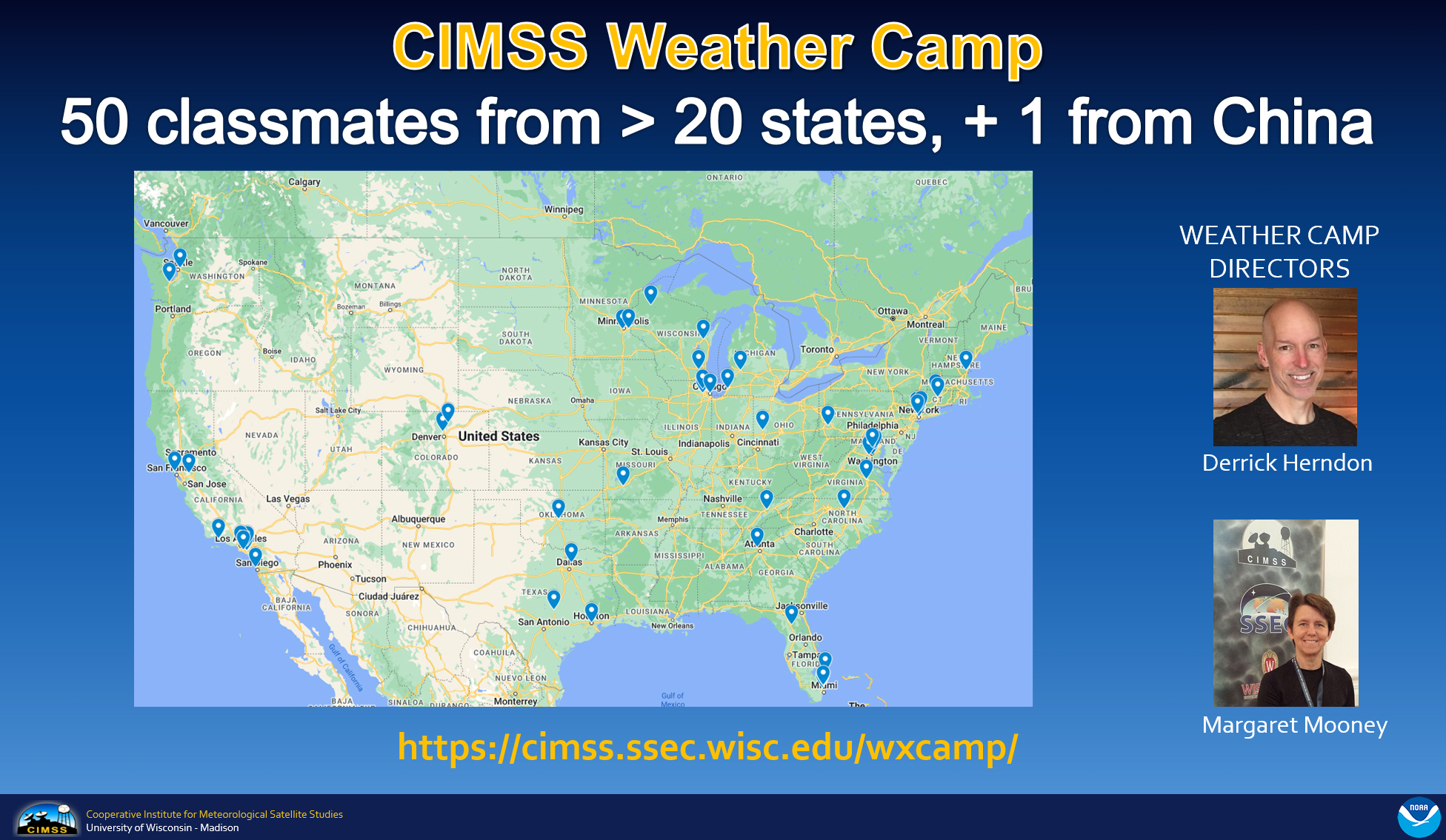
CIMSS Weather Camp: NOAA's Cooperative Institute for Meteorological Satellite Studies (CIMSS) conducted an on-line Weather Camp this week (August 7-11), co-directed by Derrick Herndon and Margaret Mooney, hosting 50 high school students from more than 20 states, including 1 participant from China. Students were enthusiastic and engaged, interacting via the chat, live polls, and word clouds, with a notable explosion in interest and engagement around Artificial Intelligence (AI) and Machine Learning (ML). Numerous researchers shared their expertise throughout the week and students learned about a different "weather job" daily, including NOAA's National Weather Service. The camp culminated with a forecast challenge and student presentations. A detailed agenda is available for download via https://cimss.ssec.wisc.edu/wxcamp/. (M. Mooney, CIMSS/SSEC, 608-265-2123; D. Herndon, CIMSS, 608-262-6741)
 (Click image to enlarge)
MEDIA INTERACTIONS AND REQUESTS:
SOCIAL MEDIA AND BLOG Posts:
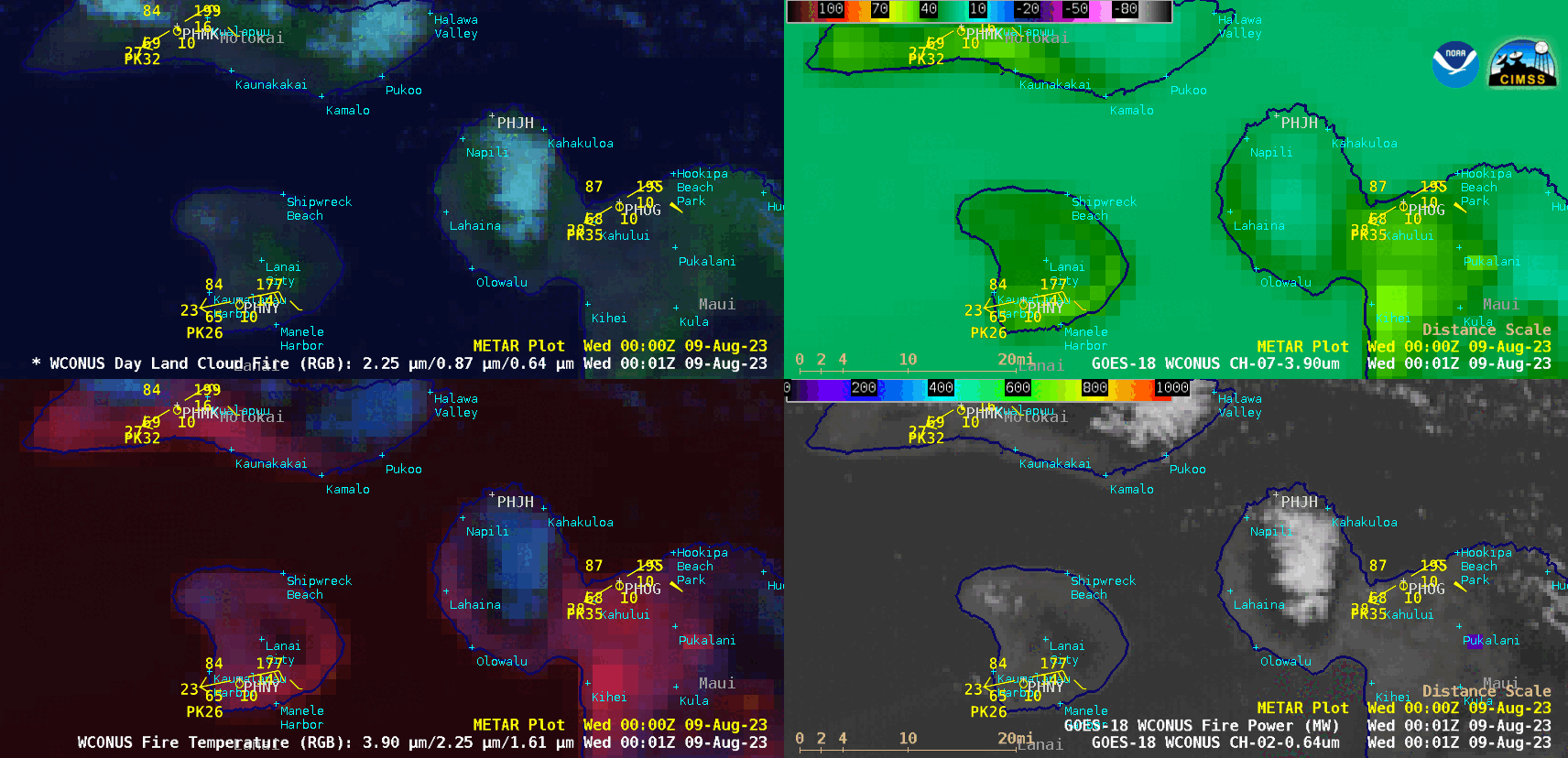
SSEC and CIMSS Scientists in the news: Scientists at the University of Wisconsin-Madison (UW) Space Science and Engineering Center (SSEC) and the Cooperative Institute for Meteorological Satellite Studies (CIMSS) provide expert interviews, imagery and case studies to promote science. This week: 1) CIMSS Satellite Blog contributors Scott Lindstrom and Scott Bachmeier published these case studies: "Wildfires on the island of Maui in Hawai`i" (August 08), "Using satellite data to describe a fire-prone environment" (August 08), "Yukon wildfire produces a pyrocumulonimbus cloud" (August 06), "Eruption of Mount Shishaldin in the Aleutian Islands" (August 04). Read more at the CIMSS Satellite Blog: https://cimss.ssec.wisc.edu/satellite-blog/. (S. Lindstrom, CIMSS, S. Bachmeier, CIMSS, E. Verbeten, SSEC)
 (Click image to enlarge)
Figure: Image toggle showing VIIRS Day Night Band before and during the fires on western Maui.
 (Click image to enlarge)
Figure: GOES-West Day Land Cloud Fire RGB, Shortwave Infrared, Fire Temperature RGB and “Red” Visible images with an overlay of Fire Power derived product showed signatures associated with wildfires on the island of Maui in Hawai`i late in the day on 08 August 2023 — particularly near Lahaina, where a large wildfire caused extensive damage and forced evacuations, with at least 55 fatalities being reported.
PUBLICATIONS:
OTHER:
| Archived Weeklies Page | Submit a report item |